Milford, New Hampshire

Last updated

Milford, New Hampshire
Town
MilfordNH Oval.jpg
The center oval and town hall
Flag of Milford, New Hampshire.svg
Milford, NH Town Seal.png
Hillsborough-Milford-NH.png
Coordinates: 42°50′07″N71°38′56″W / 42.83528°N 71.64889°W / 42.83528; -71.64889
Country United States
State New Hampshire
County Hillsborough
Incorporated 1794
Government
   Board of Selectmen
  • Gary Daniels, Chair
  • Chris Labonte
  • Paul Dargie
  • Tim Finan
  • Dave Freel
[1]
  Town AdministratorLincoln Daley
Area
[2]
  Total25.47 sq mi (65.96 km2)
  Land25.41 sq mi (65.82 km2)
  Water0.05 sq mi (0.14 km2)  0.22%
Elevation
259 ft (79 m)
Population
 (2020) [3]
  Total16,131
  Density635/sq mi (245.1/km2)
Time zone UTC-5 (Eastern)
  Summer (DST) UTC-4 (Eastern)
ZIP code
03055
Area code 603
FIPS code 33-48020
GNIS feature ID0873666
Website www.milford.nh.gov

Milford is a town in Hillsborough County, New Hampshire, United States, on the Souhegan River. The population was 16,131 at the 2020 census, [3] up from 15,115 at the 2010 census. [4] It is the retail and manufacturing center of a multi-town area known informally as the Souhegan Valley.

Contents

The town center, where 9,212 people lived at the 2020 census, is defined as the Milford census-designated place (CDP), and is located at the junction of New Hampshire routes 13 and 101A.

History

Lithograph of Milford from 1886 by L.R. Burleigh with list of landmarks Milford, N.H. (2675825826).jpg
Lithograph of Milford from 1886 by L.R. Burleigh with list of landmarks

Milford separated from neighboring Amherst in 1794. Like most towns named Milford in the United States, its name comes from the fact that it grew around a mill built on a ford—in this case on the Souhegan River. [5]

Milford was once home to numerous granite quarries, which produced a stone that was used, among other things, to make the pillars for the U.S. Treasury in Washington, D.C.—pillars that can be seen on the back of the American $10 bill. [6] [7] Its nickname remains "The Granite Town", although only one small quarry is in operation as of 2017.

Like many New England riverside towns, Milford developed several thriving textile mills in the 19th century. That industry left New England by World War II, but Milford remains the commercial and retail center for surrounding towns. Major employers included casting company Hitchiner Manufacturing Co., [8] a metal cable manufacturer, Hendrix Wire and Cable Inc., [9] and a contract manufacturing solutions company, Cirtronics Corporation. [10] In 2018, local firm Alene Candles became one of the first companies in the state to implement a "conscious leadership" program in a manufacturing production setting. [11]

Milford is home to the Milford State Fish Hatchery. [12] The town also holds the Souhegan Valley Boys & Girls Club, built on the former home of the now-bankrupt private theater American Stage Festival.

Milford was a stop on the Underground Railroad for escaped slaves.[ citation needed ] It was also the home of Harriet E. Wilson, who published the semi-autobiographical novel Our Nig: Or, Sketches in the Life of a Free Black in 1859, making it the first novel by an African-American woman published in the country.

Officially designated "Union Square", the Milford Oval is neither square nor oval in shape, but rather triangular. The "square" name in American parlance denotes a town common irrespective of geometry, and the "oval" name dates from the 19th century, when it was oval in shape. The Oval is the town center, with the Pillsbury Bandstand as its centerpiece and the Souhegan River as the backdrop. The Oval is formed by a modified traffic rotary in which State Highways 13 and 101A intersect, with northbound 13 and eastbound 101A passing straight through and crossing each other at a right angle with a stop sign for traffic on Route 13.

Geography

According to the United States Census Bureau, the town has a total area of 25.5 square miles (66.0 km2), of which 25.4 square miles (65.8 km2) are land and 0.04 square miles (0.1 km2) are water, comprising 0.22% of the town. [2] Milford is drained by the Souhegan River, an eastward-flowing tributary of the Merrimack River. The southwestern part of town is drained by Mitchell Brook and Spaulding Brook, which flow south into Brookline and are part of the Nashua River watershed, another tributary of the Merrimack. The town's highest point is near its western border, on the summit of Boynton Hill, at 814 feet (248 m) above sea level.

Adjacent municipalities

Climate

According to the Köppen Climate Classification system, Milford has a hot-summer humid continental climate, abbreviated "Dfa" on climate maps. The hottest temperature recorded in Milford was 101 °F (38.3 °C) in July 2011, while the coldest temperature recorded was −21 °F (−29.4 °C) in January 1994. [13]

Climate data for Milford, New Hampshire, 1991–2020 normals, extremes 1950–present
MonthJanFebMarAprMayJunJulAugSepOctNovDecYear
Record high °F (°C)69
(21)
76
(24)
88
(31)
95
(35)
95
(35)
99
(37)
101
(38)
100
(38)
96
(36)
87
(31)
77
(25)
71
(22)
101
(38)
Mean maximum °F (°C)54.6
(12.6)
56.2
(13.4)
66.2
(19.0)
80.9
(27.2)
88.3
(31.3)
92.1
(33.4)
93.4
(34.1)
91.7
(33.2)
87.7
(30.9)
77.6
(25.3)
68.0
(20.0)
57.6
(14.2)
95.2
(35.1)
Mean daily maximum °F (°C)33.2
(0.7)
36.2
(2.3)
44.6
(7.0)
58.3
(14.6)
69.2
(20.7)
77.5
(25.3)
83.4
(28.6)
81.2
(27.3)
72.7
(22.6)
60.4
(15.8)
48.9
(9.4)
38.1
(3.4)
58.6
(14.8)
Daily mean °F (°C)23.7
(−4.6)
25.6
(−3.6)
34.0
(1.1)
46.3
(7.9)
57.0
(13.9)
66.1
(18.9)
71.8
(22.1)
69.4
(20.8)
61.3
(16.3)
49.0
(9.4)
38.6
(3.7)
29.1
(−1.6)
47.7
(8.7)
Mean daily minimum °F (°C)14.3
(−9.8)
14.9
(−9.5)
23.5
(−4.7)
34.3
(1.3)
44.9
(7.2)
54.8
(12.7)
60.1
(15.6)
57.6
(14.2)
50.0
(10.0)
37.7
(3.2)
28.4
(−2.0)
20.0
(−6.7)
36.7
(2.6)
Mean minimum °F (°C)−5.1
(−20.6)
−2.6
(−19.2)
4.4
(−15.3)
22.3
(−5.4)
31.8
(−0.1)
41.9
(5.5)
49.8
(9.9)
46.6
(8.1)
35.0
(1.7)
24.7
(−4.1)
15.0
(−9.4)
3.4
(−15.9)
−8.3
(−22.4)
Record low °F (°C)−11
(−24)
−16
(−27)
−6
(−21)
11
(−12)
26
(−3)
34
(1)
43
(6)
41
(5)
25
(−4)
17
(−8)
7
(−14)
−9
(−23)
−16
(−27)
Average precipitation inches (mm)3.03
(77)
2.99
(76)
3.79
(96)
4.15
(105)
3.35
(85)
4.03
(102)
3.73
(95)
3.68
(93)
4.04
(103)
4.88
(124)
3.92
(100)
4.45
(113)
46.04
(1,169)
Average snowfall inches (cm)15.4
(39)
11.5
(29)
14.4
(37)
2.3
(5.8)
0.0
(0.0)
0.0
(0.0)
0.0
(0.0)
0.0
(0.0)
0.0
(0.0)
0.1
(0.25)
1.1
(2.8)
12.6
(32)
57.4
(145.85)
Average precipitation days (≥ 0.01 in)11.28.811.111.813.612.111.110.910.510.211.411.1133.8
Average snowy days (≥ 0.1 in)7.16.15.41.00.00.00.00.00.00.11.45.226.3
Source 1: NOAA [14]
Source 2: National Weather Service [13] [15]

Demographics

Historical population
CensusPop.Note
1800 939
1810 1,11719.0%
1820 1,24311.3%
1830 1,3034.8%
1840 1,45511.7%
1850 2,15948.4%
1860 2,2233.0%
1870 2,60617.2%
1880 2,308−11.4%
1890 3,01430.6%
1900 3,73924.1%
1910 3,9395.3%
1920 3,783−4.0%
1930 4,0687.5%
1940 3,927−3.5%
1950 4,1595.9%
1960 4,86316.9%
1970 6,62236.2%
1980 8,68531.2%
1990 11,79535.8%
2000 13,53514.8%
2010 15,11511.7%
2020 16,1316.7%
U.S. Decennial Census [3] [16]

As of the census of 2010, there were 15,115 people, 5,929 households, and 4,004 families residing in the town. There were 6,295 housing units, of which 366, or 5.8%, were vacant. The racial makeup of the town was 94.8% white, 1.3% African American, 0.2% Native American, 1.3% Asian, 0.01% Native Hawaiian or Pacific Islander, 0.6% some other race, and 1.7% from two or more races. 2.2% of the population were Hispanic or Latino of any race. [17]

Of the 5,929 households, 35.7% had children under the age of 18 living with them, 52.0% were headed by married couples living together, 10.5% had a female householder with no husband present, and 32.5% were non-families. 25.3% of all households were made up of individuals, and 9.4% were someone living alone who was 65 years of age or older. The average household size was 2.53, and the average family size was 3.04. [17]

In the town, 25.0% of the population was under the age of 18, 7.8% was from 18 to 24, 27.0% from 25 to 44, 28.3% from 45 to 64, and 11.9% were 65 years of age or older. The median age was 39.0 years. For every 100 females, there were 95.8 males. For every 100 females aged 18 and over, there were 93.3 males. [17]

For the period 2011–2015, the estimated median annual income for a household was $64,576, and the median income for a family was $80,241. Male full-time workers had a median income of $55,313 versus $38,792 for females. The per capita income for the town was $32,918. 5.8% of the population and 3.7% of families were below the poverty line. 8.2% of the population under the age of 18 and 2.7% of those 65 or older were living in poverty. [18]

Education

Milford High School & Applied Technology Center Milford High School, Milford NH.jpg
Milford High School & Applied Technology Center

The Milford School District operates Jacques Memorial School (K-1), Heron Pond Elementary School (2-5), Milford Middle School (6-8), and Milford High School & Applied Technology Center (9-12). [19]

Culture

The town is known for its "Pumpkin Festival", which is normally held in early October. [20] It is held over a three-day weekend (Friday-Sunday) and attracts more than 35,000 people. The festival has many attractions including food vendors, music stages, craft fair, carved pumpkin lighting, a haunted trail, a beer and wine tasting and a fireworks display around the Oval.

Notable people

See also

Related Research Articles

<span class="mw-page-title-main">Hillsborough County, New Hampshire</span> County in New Hampshire, United States

Hillsborough County is the most populous county in the U.S. state of New Hampshire. As of the 2020 census, the population was 422,937, almost one-third the population of the entire state. Its county seats are Manchester and Nashua, the state's two biggest cities. Hillsborough is northern New England's most populous county as well as its most densely populated.

<span class="mw-page-title-main">Amherst, New Hampshire</span> Town in New Hampshire, United States

Amherst is a town in Hillsborough County in the state of New Hampshire, United States. The population was 11,753 at the 2020 census. Amherst is home to Ponemah Bog Wildlife Sanctuary, Hodgman State Forest, the Joe English Reservation and Baboosic Lake.

<span class="mw-page-title-main">Bennington, New Hampshire</span> Town in New Hampshire, United States

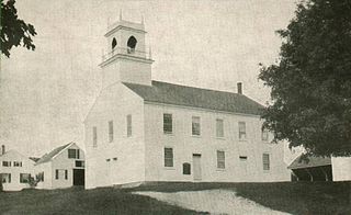
Bennington is a town in Hillsborough County, New Hampshire, United States. The population was 1,501 at the 2020 census.

<span class="mw-page-title-main">Brookline, New Hampshire</span> Town in New Hampshire, United States

Brookline is a town in Hillsborough County, New Hampshire, United States. The population was 5,639 at the 2020 census, up from 4,991 at the 2010 census. Brookline is home to the Talbot-Taylor Wildlife Sanctuary, Potanipo Pond, and the Brookline Covered Bridge.

<span class="mw-page-title-main">Deering, New Hampshire</span> Town in New Hampshire, United States

Deering is a town in Hillsborough County, New Hampshire, United States. The population was 1,904 at the 2020 census.

<span class="mw-page-title-main">Greenfield, New Hampshire</span> Town in New Hampshire, United States

Greenfield is a town in Hillsborough County, New Hampshire, United States. The population was 1,716 at the 2020 census. Greenfield is home to the Crotched Mountain Rehabilitation Center, to Greenfield State Park, and to part of the Wapack Trail.

<span class="mw-page-title-main">Lyndeborough, New Hampshire</span> Town in New Hampshire, United States

Lyndeborough is a town in Hillsborough County, New Hampshire, United States. The population was 1,702 at the 2020 census.

<span class="mw-page-title-main">Mason, New Hampshire</span> Town in New Hampshire, United States

Mason is a town in Hillsborough County, New Hampshire, United States. The population was 1,448 at the 2020 census. Mason, together with Wilton, is home to Russell-Abbott State Forest.

<span class="mw-page-title-main">Merrimack, New Hampshire</span> Town in New Hampshire, United States

Merrimack is a town in Hillsborough County, New Hampshire, United States. The population was 26,632 as of the 2020 census.

<span class="mw-page-title-main">Mont Vernon, New Hampshire</span> Town in New Hampshire, United States

Mont Vernon is a town in Hillsborough County, New Hampshire, United States. The population was 2,584 at the 2020 census, up from 2,409 at the 2010 census.

<span class="mw-page-title-main">New Boston, New Hampshire</span> Town in New Hampshire, United States

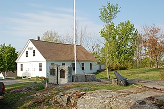
New Boston is a town in Hillsborough County, New Hampshire, United States. The population was 6,108 at the 2020 census, up from 5,321 at the 2010 census. New Boston is home to the annual Hillsborough County Agricultural Fair and the Molly Stark Cannon. The 1743 cannon, which appears on the town seal, was given by General John Stark to the New Boston Artillery Company after the Battle of Bennington.

<span class="mw-page-title-main">New Ipswich, New Hampshire</span> Town in New Hampshire, United States

New Ipswich is a town in Hillsborough County, New Hampshire, United States. The population was 5,204 at the 2020 census. New Ipswich, situated on the Massachusetts border, includes the villages of Bank, Davis, Gibson Four Corners, Highbridge, New Ipswich Center, Smithville, and Wilder, though these village designations no longer hold the importance they did in the past. The Wapack Trail passes through the community.

<span class="mw-page-title-main">Sharon, New Hampshire</span> Town in New Hampshire, United States

Sharon is a town in Hillsborough County, New Hampshire, United States. The population was 359 at the 2020 census. It was the long-time home to the Sharon Arts Center, a nonprofit which has ceased operations.

<span class="mw-page-title-main">Temple, New Hampshire</span> Town in New Hampshire, United States

Temple is a town in Hillsborough County, New Hampshire, United States. The population was 1,382 at the 2020 census. It is home to Temple Mountain State Reservation, formerly the Temple Mountain Ski Area.

<span class="mw-page-title-main">Weare, New Hampshire</span> Town in New Hampshire, United States

Weare is a town in Hillsborough County, New Hampshire, United States. The population was 9,092 at the 2020 census. It is close to two important New Hampshire cities, Manchester and Concord.

<span class="mw-page-title-main">Antrim, New Hampshire</span> Town in New Hampshire, United States

Antrim is a town in Hillsborough County, New Hampshire, United States. The population was 2,651 at the 2020 census. The main village in the town, where 1,395 people lived at the 2020 census, is defined as the Antrim census-designated place (CDP) and is located at the intersection of U.S. Route 202 and New Hampshire Route 31. The town of Antrim also includes the villages of Antrim Center, North Branch, and Clinton Village.

<span class="mw-page-title-main">Greenville, New Hampshire</span> Town in New Hampshire, United States

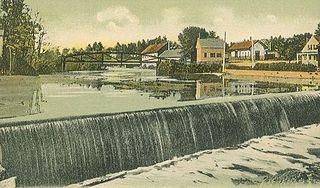
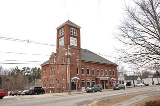
Greenville is a town in Hillsborough County, New Hampshire, United States. The population was 1,974 at the 2020 census, down from 2,105 at the 2010 census. It is located at the junctions of New Hampshire routes 31, 45, and 123.

<span class="mw-page-title-main">Milford (CDP), New Hampshire</span> Census-designated place in New Hampshire, United States

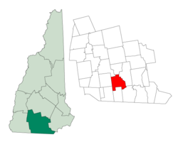
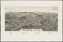
Milford is a census-designated place (CDP) and the main village in the town of Milford, Hillsborough County, New Hampshire, United States. The population of the CDP was 9,212 at the 2020 census, out of 16,131 in the entire town.

<span class="mw-page-title-main">Wilton (CDP), New Hampshire</span> Census-designated place in New Hampshire, United States

Wilton is a census-designated place (CDP) and the main village in the town of Wilton, Hillsborough County, New Hampshire, United States. The CDP extends east into the town of Milford as well. The population of the CDP was 1,324 at the 2020 census, up from 1,163 at the 2010 census.

<span class="mw-page-title-main">Wilton, New Hampshire</span> Town in New Hampshire, United States

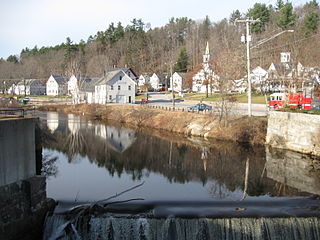
Wilton is a town in Hillsborough County, New Hampshire, United States. The population was 3,896 at the 2020 census. Like many small New England towns, it grew up around water-powered textile mills, but is now a rural bedroom community with some manufacturing and service employment. Wilton is home to the High Mowing School, a private preparatory school.

References

  1. "Board of Selectmen". Town of Milford. Retrieved July 19, 2023.
  2. 1 2 "2021 U.S. Gazetteer Files – New Hampshire". United States Census Bureau. Retrieved December 9, 2021.
  3. 1 2 3 "Milford town, Hillsborough County, New Hampshire: 2020 DEC Redistricting Data (PL 94-171)". U.S. Census Bureau. Retrieved December 9, 2021.
  4. United States Census Bureau, U.S. Census website, 2010 Census figures. Retrieved March 23, 2011.
  5. Coolidge, Austin J.; John B. Mansfield (1859). A History and Description of New England. Boston, Massachusetts: A.J. Coolidge. pp.  580. coolidge mansfield history description new england 1859.
  6. "Milford granite used for treasury building column". Milford Cabinet, April 26, 2012
  7. Milford Cabinet: "Not carved in stone" Feb. 2, 2017
  8. Cote, Mike. "Mike Cote's Business Editor's Notebook: Bringing high-end training to the workplace". Union Leader. Retrieved July 17, 2018.
  9. Seiler, Paul Steven (2013). "Hendrix Covered Conductor Manual" (PDF). Western Power. p. 7.
  10. Veasey, Michelle (May 10, 2017). "Cirtronics Wins Award for Corporate Social Responsibility Practices". MassTLC - Mass Technology Leadership Council. Retrieved July 17, 2018.
  11. Houghton, Kimberly (July 15, 2018). "Milford candle company embraces conscious leadership". Union Leader. Retrieved July 17, 2018.
  12. "New Hampshire Wildlife Management Areas". New Hampshire Fish and Game Department. Retrieved July 17, 2018.
  13. 1 2 "NOAA Online Weather Data – NWS Gray/Portland". National Weather Service. Retrieved March 4, 2023.
  14. "U.S. Climate Normals Quick Access – Station: Milford, NH". National Oceanic and Atmospheric Administration. Retrieved March 4, 2023.
  15. "xmACIS2". National Oceanic and Atmospheric Administration. Retrieved March 4, 2023.
  16. "Census of Population and Housing". Census.gov. Retrieved June 4, 2016.
  17. 1 2 3 "Profile of General Population and Housing Characteristics: 2010 Census Summary File 1 (DP-1): Milford town, Hillsborough County, New Hampshire". American Factfinder. U.S. Census Bureau. Archived from the original on February 13, 2020. Retrieved November 2, 2017.
  18. "Selected Economic Characteristics: 2011-2015 American Community Survey 5-Year Estimates (DP03): Milford town, Hillsborough County, New Hampshire". American Factfinder. U.S. Census Bureau. Archived from the original on February 13, 2020. Retrieved November 2, 2017.
  19. "Home". Milford School District. Retrieved April 24, 2022. - Grade breakdown from National Center for Education Statistics
  20. "Milford Pumpkin Festival 2015". Milford Pumpkin Festival.
  21. "Linda Kasabian biography". Bio.True Story. Retrieved December 14, 2013.