Atkinson, New Hampshire

Last updated

Atkinson, New Hampshire
Main Street, Atkinson NH.jpg
Main Street
Rockingham County New Hampshire incorporated and unincorporated areas Atkinson highlighted.svg
Location in Rockingham County and the state of New Hampshire.
Coordinates: 42°50′18″N71°08′49″W / 42.83833°N 71.14694°W / 42.83833; -71.14694
Country United States
State New Hampshire
County Rockingham
Incorporated 1767 [1]
Government
  TypeSB2
   Board of Selectmen
  • Beth Cacciotti, Chair
  • William Baldwin
  • Gregory Spero
  • David Paquette
  • Robert Worden
  Town AdministratorJohn Apple
Area
[2]
  Total11.4 sq mi (29.4 km2)
  Land11.2 sq mi (28.9 km2)
  Water0.2 sq mi (0.5 km2)  1.61%
Elevation
302 ft (92 m)
Population
 (2020) [3]
  Total7,087
  Density635/sq mi (245.3/km2)
Time zone UTC-5 (Eastern)
  Summer (DST) UTC-4 (Eastern)
ZIP code
03811
Area code 603
FIPS code 33-02340
GNIS feature ID0873535
Website www.town-atkinsonnh.com

Atkinson is a town in Rockingham County, New Hampshire, United States. The population was 7,087 at the 2020 census. [3]

Contents

History

Atkinson's history dates back to the American Revolution. The community was incorporated September 3, [4] [5] 1767, [6] and was named after Colonel Theodore Atkinson, [4] a local landowner. [7]

Atkinson Academy, the second-oldest co-educational school in the country, [8] was founded as a boys' school in 1787 by Reverend Stephen Peabody, General Nathaniel Peabody and Doctor William Cogswell; it began admitting girls in 1791. The school building burned to the ground in 1802, and was rebuilt in 1803 at a cost of $2,500. That building remains a part of the academy, which has since been expanded, with only four classrooms.

The Kimball House Museum occupies a structure that was built in 1772 by the Reverend Stephen Peabody. In April 1907, Rev. Joseph A. Kimball, a summer resident, purchased the building from the Maddocks family in order to create a library for the town. [9]

Atkinson's history can be read about in the book Atkinson Then and Now, which can be purchased at the Atkinson Public Library on Academy Avenue.

Atkinson celebrated its 250th anniversary on Labor Day weekend 2017. [10]

Geography

Atkinson is in southeastern New Hampshire, in the southwestern part of Rockingham County. It is bordered to the south by the city of Haverhill in Essex County, Massachusetts.

According to the United States Census Bureau, the town has a total area of 11.4 square miles (29.4 km2), of which 11.2 square miles (28.9 km2) are land and 0.2 square miles (0.5 km2) are water, comprising 1.61% of the town. [2] The highest point in Atkinson is Hog Hill, north of the town center, at 430 feet (130 m) above sea level. Atkinson is drained to the west by tributaries of the Spicket River and to the east by tributaries of the Little River, both southward-flowing tributaries of the Merrimack River. [11]

In 2011 the New Hampshire Scenic and Cultural Byways program named 3.74 miles (6.02 km) of Main Street the "Stage Coach Byway". [12]

Adjacent municipalities

Demographics

Historical population
CensusPop.Note
1790 479
1800 474−1.0%
1810 55617.3%
1820 5631.3%
1830 555−1.4%
1840 5672.2%
1850 6005.8%
1860 546−9.0%
1870 488−10.6%
1880 5022.9%
1890 483−3.8%
1900 442−8.5%
1910 440−0.5%
1920 413−6.1%
1930 407−1.5%
1940 4346.6%
1950 49213.4%
1960 1,017106.7%
1970 2,291125.3%
1980 4,39791.9%
1990 5,18818.0%
2000 6,17819.1%
2010 6,7519.3%
2020 7,0875.0%
U.S. Decennial Census [3] [13]

As of the census [14] of 2000, there were 6,178 people, 2,317 households, and 1,777 families residing in the town. The population density was 555.2 inhabitants per square mile (214.4/km2). There were 2,431 housing units at an average density of 218.5 per square mile (84.4/km2). The racial makeup of the town was 97.62% White, 0.26% African American, 0.06% Native American, 1.18% Asian, 0.21% from other races, and 0.66% from two or more races. Hispanic or Latino of any race were 0.70% of the population.

There were 2,317 households, out of which 32.5% had children under the age of 18 living with them, 68.8% were married couples living together, 5.7% had a female householder with no husband present, and 23.3% were non-families. 19.0% of all households were made up of individuals, and 6.4% had someone living alone who was 65 years of age or older. The average household size was 2.66 and the average family size was 3.08.

In the town, the population was spread out, with 24.5% under the age of 18, 5.0% from 18 to 24, 28.4% from 25 to 44, 30.7% from 45 to 64, and 11.4% who were 65 years of age or older. The median age was 41 years. For every 100 females, there were 94.9 males. For every 100 females age 18 and over, there were 96.1 males.

The median income for a household in the town was $69,729, and the median income for a family was $77,631. Males had a median income of $53,229 versus $34,760 for females. The per capita income for the town was $30,412. About 2.3% of families and 3.3% of the population were below the poverty line, including 4.5% of those under age 18 and 2.2% of those age 65 or over.

Transportation

Two New Hampshire state routes cross Atkinson.

The nearest airport is Manchester–Boston Regional Airport along the border of Londonderry and Manchester. The nearest rail service is the Haverhill Line of the MBTA Commuter Rail at Haverhill station in Massachusetts, which also serves as the Amtrak station.

Education

Atkinson Public Schools are part of the Timberlane Regional School District. The district serves the communities of Atkinson, Danville, Plaistow and Sandown. The district has five elementary schools, a middle school and a high school. Students in Atkinson attend Atkinson Academy (claimed to be the oldest co-educational school still standing in the United States), Timberlane Regional Middle School, and Timberlane Regional High School. [15] [16]

Notable people

Related Research Articles

<span class="mw-page-title-main">Essex County, Massachusetts</span> County in Massachusetts, United States

Essex County is a county in the northeastern part of the U.S. state of Massachusetts. At the 2020 census, the total population was 809,829, making it the third-most populous county in the state, and the seventy-eighth-most populous in the country. It is part of the Greater Boston area. The largest city in Essex County is Lynn. The county was named after the English county of Essex. It has two traditional county seats: Salem and Lawrence. Prior to the dissolution of the county government in 1999, Salem had jurisdiction over the Southern Essex District, and Lawrence had jurisdiction over the Northern Essex District, but currently these cities do not function as seats of government. However, the county and the districts remain as administrative regions recognized by various governmental agencies, which gathered vital statistics or disposed of judicial case loads under these geographic subdivisions, and are required to keep the records based on them. The county has been designated the Essex National Heritage Area by the National Park Service.

<span class="mw-page-title-main">Rockingham County, New Hampshire</span> County in New Hampshire, United States

Rockingham County is a county in the U.S. state of New Hampshire. As of the 2020 census, the population was 314,176, making it New Hampshire's second-most populous county. The county seat is Brentwood. Rockingham County is part of the Boston-Cambridge-Newton, MA-NH Metropolitan Statistical Area and the greater Boston-Worcester-Providence, MA-RI-NH-CT Combined Statistical Area. Per the 2020 census, it was New Hampshire's fastest growing county from 2010 to 2020.

<span class="mw-page-title-main">Merrimack County, New Hampshire</span> County in New Hampshire, United States

Merrimack County is a county in the U.S. state of New Hampshire. As of the 2020 Census, the population was 153,808, making it the third most populous county in New Hampshire. Its county seat is Concord, the state capital. The county was organized in 1823 from parts of Hillsborough and Rockingham counties, and is named for the Merrimack River. Merrimack County comprises the Concord, NH Micropolitan Statistical Area, which in turn constitutes a portion of the Boston–Worcester–Providence, MA–RI–NH–CT Combined Statistical Area. In 2010, the center of population of New Hampshire was located in Merrimack County, in the town of Pembroke.

<span class="mw-page-title-main">Grafton County, New Hampshire</span> County in New Hampshire, United States

Grafton County is a county in the U.S. state of New Hampshire. As of the 2020 census, the population was 91,118. Its county seat is the town of Haverhill. In 1972, the county courthouse and other offices were moved from Woodsville, a larger village within the town of Haverhill, to North Haverhill.

<span class="mw-page-title-main">Piermont, New Hampshire</span> Town in New Hampshire, United States

Piermont is a town in Grafton County, New Hampshire, United States. The population was 769 at the 2020 census. It is home to Camp Walt Whitman and Kingswood Camp for Boys.

<span class="mw-page-title-main">Pelham, New Hampshire</span> Town in New Hampshire, United States

Pelham is a town in Hillsborough County, New Hampshire, United States. The population was 14,222 at the 2020 census, up from 12,897 at the 2010 census.

<span class="mw-page-title-main">Brentwood, New Hampshire</span> Place in New Hampshire, United States

Brentwood is a town in Rockingham County, New Hampshire, United States. At the 2020 census, its population was 4,490. Brentwood has been the county seat of Rockingham County since 1997.

<span class="mw-page-title-main">Chester, New Hampshire</span> Town in New Hampshire, United States

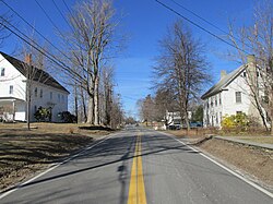
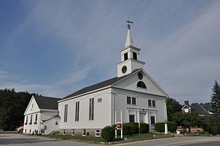
Chester is a town in Rockingham County, New Hampshire, United States. The population was 5,232 at the 2020 census, up from 4,768 at the 2010 census. It was home to the now defunct Chester College.

<span class="mw-page-title-main">Danville, New Hampshire</span> Town in New Hampshire, United States

Danville is a town in Rockingham County, New Hampshire, United States. The population was 4,408 at the 2020 census. Danville is part of the Timberlane Regional School District, with students attending Danville Elementary School, Timberlane Regional Middle School, and Timberlane Regional High School.

<span class="mw-page-title-main">Hampstead, New Hampshire</span> Place in New Hampshire, United States

Hampstead is a town in Rockingham County, New Hampshire, United States. The population was 8,998 at the 2020 census. Hampstead, which includes the village of East Hampstead, is home to a portion of the Rockingham Recreational Trail.

<span class="mw-page-title-main">Kingston, New Hampshire</span> Place in New Hampshire, United States

Kingston is a town in Rockingham County, New Hampshire, United States. The population at the 2020 census was 6,202.

<span class="mw-page-title-main">Newton, New Hampshire</span> Place in New Hampshire, United States

Newton is a town in Rockingham County, New Hampshire, United States. The population was 4,820 at the 2020 census.

<span class="mw-page-title-main">Plaistow, New Hampshire</span> Place in New Hampshire, United States

Plaistow is a town in Rockingham County, New Hampshire, United States. The population was 7,830 at the 2020 census.

<span class="mw-page-title-main">Salem, New Hampshire</span> Town in New Hampshire, United States

Salem is a town in Rockingham County, New Hampshire, United States. The population was 30,089 at the 2020 census and an estimated 30,647 in 2022. Salem is a northern suburb of Boston located on Interstate 93. As the first town along I-93 northbound in New Hampshire, which lacks any state sales tax, Salem has grown into a regional commercial hub for many nearby Massachusetts towns, anchored by the Mall at Rockingham Park and Tuscan Village. Other major sites include Canobie Lake Park, a large amusement park; and America's Stonehenge, a stone structure of disputed origins. It is the former home of Rockingham Park, a horse racetrack. The Sununu political family hails from Salem, including former New Hampshire governor and White House Chief of Staff John H. Sununu, and his sons John E. Sununu, a former U.S. senator, and Chris Sununu, current New Hampshire governor.

<span class="mw-page-title-main">Sandown, New Hampshire</span> Town in New Hampshire, United States

Sandown is a town in Rockingham County, New Hampshire, United States. The population was 6,548 at the 2020 census, up from 5,986 at the 2010 census.

<span class="mw-page-title-main">Epping (CDP), New Hampshire</span> Census-designated place in New Hampshire, United States

Epping is a census-designated place (CDP) and the main village in the town of Epping, Rockingham County, New Hampshire, United States. The population of the CDP was 2,693 at the 2020 census, out of 7,125 in the entire town.

<span class="mw-page-title-main">Londonderry, New Hampshire</span> Town in Rockingham County, New Hampshire, United States of America

Londonderry is a town in western Rockingham County, New Hampshire, United States. It sits between Manchester and Derry, the largest and fourth-largest communities in the state. The population was 25,826 at the 2020 census. Londonderry is known for its apple orchards and is home to the headquarters of Stonyfield Farm and part of Manchester–Boston Regional Airport.

<span class="mw-page-title-main">Derry, New Hampshire</span> Town in New Hampshire, United States

Derry is a town in Rockingham County, New Hampshire, United States. The population was 34,317 at the 2020 census. Although it is a town and not a city, Derry is the most populous community in Rockingham County and the 4th most populous in the state. The town's nickname, "Spacetown", derives from the fact that Derry is the birthplace of Alan Shepard, the first astronaut from the United States in space. Derry was also for a time the home of the poet Robert Frost and his family.

<span class="mw-page-title-main">New Hampshire Route 121</span> State highway in southeastern New Hampshire, US

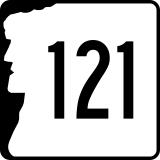
New Hampshire Route 121 is a 22.555-mile-long (36.299 km) north–south state highway in Rockingham and Hillsborough counties in southeastern New Hampshire. The road winds through the communities of Atkinson, Hampstead, Sandown, Derry, Chester, and Auburn. The southern terminus of NH 121 is at the Massachusetts state line in Plaistow, where the road, named Atkinson Depot Road, continues into the city of Haverhill as an unnumbered local road leading to Route 125. The northern terminus is at a traffic circle, where NH 121 meets New Hampshire Route 28 Bypass in eastern Manchester. At this point, the road is known as Manchester Road.

Timberlane Regional High School is located in Plaistow, New Hampshire, and serves as a regional high school for the towns of Atkinson, Danville, Plaistow, and Sandown, New Hampshire. The school was built in 1966 and is a part of the Timberlane Regional School District. Timberlane Regional High School is a co-educational school for grades 9-12. The school has won the 1996, 1997 and 2014 Excellence In Education Award. As of 2005, the school has approximately 1,400 students on roll. The school mascot is the owl. The school is regionally accredited for its award-winning wrestling team, which holds 28 NH State Wrestling Champions titles, as of 2020.

References

  1. "Community Profiles: Atkinson, NH". NH Economic & Labor Market Information Bureau. Retrieved February 2, 2023.
  2. 1 2 "2021 U.S. Gazetteer Files – New Hampshire". United States Census Bureau. Retrieved December 17, 2021.
  3. 1 2 3 "Atkinson town, Rockingham County, New Hampshire: 2020 DEC Redistricting Data (PL 94-171)". U.S. Census Bureau. Retrieved December 17, 2021.
  4. 1 2 Article in Statistics and Gazetteer of New-Hampshire (1875)
  5. Article in Hayward's New England Gazetteer (1839)
  6. "Town of Atkinson New Hampshire". Town of Atkinson New Hampshire. Retrieved November 10, 2012.
  7. "Profile for Atkinson, New Hampshire, NH". ePodunk. Retrieved November 10, 2012.
  8. Montalto, Jim (July 28, 2006). "School to many of Atkinson's own". The Eagle-Tribune . Retrieved December 21, 2009.
  9. "Kimball House Museum/Library History". Atkinson NH Historical Society. Archived from the original on August 12, 2013. Retrieved November 10, 2012.
  10. "Celebrate Atkinson". atkinsonnh250th.com. Retrieved August 30, 2017.
  11. Foster, Debra H.; Batorfalvy, Tatianna N.; Medalie, Laura (1995). Water Use in New Hampshire: An Activities Guide for Teachers. U.S. Department of the Interior and U.S. Geological Survey.
  12. Hogan, Cara (August 3, 2011). "Atkinson's Main Street earns special designation". Eagle Tribune. Retrieved April 24, 2013.
  13. "Census of Population and Housing". Census.gov. Retrieved June 4, 2016.
  14. "U.S. Census website". United States Census Bureau . Retrieved January 31, 2008.
  15. "Timberlane Regional School District". Timberlane Regional School District. Retrieved November 10, 2012.
  16. "Timberlane Regional School District". education.com. Retrieved November 10, 2012.
  17. Pareles, Jon (March 10, 2007). "Brad Delp, 55, Lead Singer for Boston, Dies". The New York Times. ISSN   0362-4331 . Retrieved March 30, 2016.