Kensington, New Hampshire

Last updated

Kensington, New Hampshire
KensingtonNH Library.jpg
The public library, listed on the National Register of Historic Places
Kensington, NH Town Seal.png
Rockingham County New Hampshire incorporated and unincorporated areas Kensington highlighted.svg
Location in Rockingham County and the state of New Hampshire.
Coordinates: 42°55′37″N70°56′38″W / 42.92694°N 70.94389°W / 42.92694; -70.94389
Country United States
State New Hampshire
County Rockingham
Incorporated 1737
Government
   Board of Selectmen
  • Joe Pace, Chair
  • Bob Solomon
  • Bob Gustafson
   Town Administrator Kathleen T. Felch
Area
[1]
  Total11.98 sq mi (31.03 km2)
  Land11.97 sq mi (30.99 km2)
  Water0.02 sq mi (0.04 km2)  0.12%
Elevation
115 ft (35 m)
Population
 (2020)
  Total2,095
  Density175/sq mi (67.6/km2)
Time zone UTC-5 (Eastern)
  Summer (DST) UTC-4 (Eastern)
ZIP code
03833
Area code 603
FIPS code 33-39780
GNIS feature ID0873636
Website www.town.kensington.nh.us

Kensington is a town in Rockingham County, New Hampshire, United States. The population was 2,095 at the 2020 census. [2]

Contents

History

Once a parish of Hampton, Kensington was incorporated in 1737 by New Hampshire governor Jonathan Belcher. Of the 27 towns granted by Governor Belcher, only three were given names, one of which was Kensington, named for Baron Kensington, owner of Kensington Palace in London. [3]

Geography

According to the United States Census Bureau, the town has a total area of 12.0 square miles (31.0 km2), of which 0.02 square miles (0.04 km2) are water, comprising 0.12% of the town. [1] Kensington is home to 16 named hills of glacial drumlin origin; the highest, Indian Ground Hill, located on the town's border with South Hampton, is 305 feet (93 m) above sea level. The majority of Kensington lies within the Piscataqua River watershed, via the Exeter River. The southeast portion of town drains to Hampton Harbor via the Taylor and Hampton Falls rivers, and the southwest corner of the town drains to the Merrimack River. [4]

Adjacent municipalities

Demographics

Historical population
CensusPop.Note
1790 800
1800 776−3.0%
1810 7810.6%
1820 709−9.2%
1830 7171.1%
1840 647−9.8%
1850 7008.2%
1860 672−4.0%
1870 642−4.5%
1880 614−4.4%
1890 547−10.9%
1900 524−4.2%
1910 417−20.4%
1920 383−8.2%
1930 43814.4%
1940 4584.6%
1950 54218.3%
1960 70830.6%
1970 1,04447.5%
1980 1,32226.6%
1990 1,63123.4%
2000 1,89316.1%
2010 2,12412.2%
2020 2,095−1.4%
U.S. Decennial Census [5]

As of the census [6] of 2000, there were 1,893 people, 657 households, and 532 families residing in the town. The population density was 158.4 inhabitants per square mile (61.2/km2). There were 672 housing units at an average density of 56.2 per square mile (21.7/km2). The racial makeup of the town was 98.31% White, 0.11% African American, 0.21% Native American, 0.63% Asian, and 0.74% from two or more races.

There were 657 households, out of which 40.3% had children under the age of 18 living with them, 72.9% were married couples living together, 5.8% had a female householder with no husband present, and 18.9% were non-families. 13.4% of all households were made up of individuals, and 4.9% had someone living alone who was 65 years of age or older. The average household size was 2.88 and the average family size was 3.18.

In the town, the population was spread out, with 27.8% under the age of 18, 5.0% from 18 to 24, 32.0% from 25 to 44, 25.4% from 45 to 64, and 9.8% who were 65 years of age or older. The median age was 39 years. For every 100 females, there were 97.6 males. For every 100 females age 18 and over, there were 100.0 males.

The median income for a household in the town was $67,344, and the median income for a family was $72,679. Males had a median income of $56,023 versus $35,278 for females. The per capita income for the town was $29,265. About 3.4% of families and 4.6% of the population were below the poverty line, including 5.1% of those under age 18 and 4.6% of those age 65 or over.

Notable people

Sites of interest

Related Research Articles

<span class="mw-page-title-main">Rockingham County, New Hampshire</span> County in New Hampshire, United States

Rockingham County is a county in the U.S. state of New Hampshire. As of the 2020 census, the population was 314,176, making it New Hampshire's second-most populous county. The county seat is Brentwood. Rockingham County is part of the Boston-Cambridge-Newton, MA-NH Metropolitan Statistical Area and the greater Boston-Worcester-Providence, MA-RI-NH-CT Combined Statistical Area. Per the 2020 census, it was New Hampshire's fastest growing county from 2010 to 2020.

<span class="mw-page-title-main">Chester, New Hampshire</span> Town in New Hampshire, United States

Chester is a town in Rockingham County, New Hampshire, United States. The population was 5,232 at the 2020 census, up from 4,768 at the 2010 census. It was home to the now defunct Chester College.

<span class="mw-page-title-main">East Kingston, New Hampshire</span> Place in New Hampshire, United States

East Kingston is a town in Rockingham County, New Hampshire, United States. The population was 2,441 at the 2020 census.

<span class="mw-page-title-main">Fremont, New Hampshire</span> American town

Fremont is a town in Rockingham County, New Hampshire, United States. The population was 4,739 at the 2020 census, up from 4,283 at the 2010 census. Fremont is crossed by the Rockingham Recreation Trail and NH Route 107.

<span class="mw-page-title-main">Greenland, New Hampshire</span> Place in New Hampshire, United States

Greenland is a town in Rockingham County, New Hampshire, United States. The population was 4,067 at the 2020 census, up from 3,549 at the 2010 census. It is drained by the Winnicut River and bounded on the northwest by Great Bay.

<span class="mw-page-title-main">Hampton Falls, New Hampshire</span> Place in New Hampshire, United States

Hampton Falls is a town in Rockingham County, New Hampshire, United States. The population was 2,403 at the 2020 census.

<span class="mw-page-title-main">Kingston, New Hampshire</span> Place in New Hampshire, United States

Kingston is a town in Rockingham County, New Hampshire, United States. The population at the 2020 census was 6,202.

<span class="mw-page-title-main">Newfields, New Hampshire</span> Place in New Hampshire, United States

Newfields is a town in Rockingham County, New Hampshire, United States. The population was 1,769 at the 2020 census. The primary village in town, where 378 people resided at the 2020 census, is defined as the Newfields census-designated place (CDP) and is located along New Hampshire Route 85 and the Squamscott River. It is a quaint village of handsome old houses.

<span class="mw-page-title-main">Newton, New Hampshire</span> Place in New Hampshire, United States

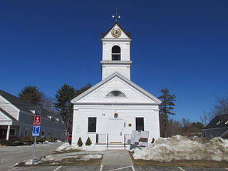
Newton is a town in Rockingham County, New Hampshire, United States. The population was 4,820 at the 2020 census.

<span class="mw-page-title-main">North Hampton, New Hampshire</span> Place in New Hampshire, United States

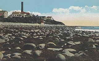
North Hampton is a town in Rockingham County, New Hampshire, United States. The population was 4,538 at the 2020 census. While the majority of the town is inland, North Hampton includes a part of New Hampshire's limited Atlantic seacoast.

<span class="mw-page-title-main">Sandown, New Hampshire</span> Town in New Hampshire, United States

Sandown is a town in Rockingham County, New Hampshire, United States. The population was 6,548 at the 2020 census, up from 5,986 at the 2010 census.

<span class="mw-page-title-main">Seabrook, New Hampshire</span> Town in New Hampshire, United States

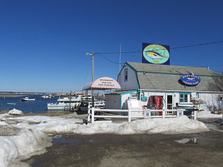
Seabrook is a town in Rockingham County, New Hampshire, United States. The population was 8,401 at the 2020 census. Located at the southern end of the coast of New Hampshire, on the border with Massachusetts, Seabrook is noted as the location of the Seabrook Station Nuclear Power Plant, the third-most recently constructed nuclear power plant in the United States.

<span class="mw-page-title-main">South Hampton, New Hampshire</span> Town in New Hampshire, United States

South Hampton is a town in Rockingham County, New Hampshire, United States. The population was 894 at the 2020 census. South Hampton is home to Cowden State Forest and Powwow River State Forest.

<span class="mw-page-title-main">Stratham, New Hampshire</span> Town in New Hampshire, United States

Stratham is a town in Rockingham County, New Hampshire, United States. The town had a population of 7,669 at the 2020 census. It is bounded on the west by the Squamscott River. The town is the home of the only U.S. Lindt & Sprüngli factory and the headquarters of the Timberland Corporation.

<span class="mw-page-title-main">Epping, New Hampshire</span> Place in New Hampshire, United States

Epping is a town in Rockingham County, New Hampshire, United States. The population was 7,125 at the 2020 census, up from 6,411 at the 2010 census.

<span class="mw-page-title-main">Exeter (CDP), New Hampshire</span> Census-designated place in New Hampshire, United States

Exeter is a census-designated place (CDP) and the main village in the town of Exeter, Rockingham County, New Hampshire, United States. The population of the CDP was 10,109 at the 2020 census, out of 16,049 in the entire town.

<span class="mw-page-title-main">Hampton (CDP), New Hampshire</span> Census-designated place in New Hampshire, United States

Hampton is a census-designated place (CDP) comprising the town center and surrounding developed areas of the town of Hampton, Rockingham County, New Hampshire, United States. The population of the CDP was 9,597 at the 2020 census, out of 16,214 in the entire town.

<span class="mw-page-title-main">Hampton, New Hampshire</span> Place in New Hampshire, United States

Hampton is a town in Rockingham County, New Hampshire, United States. The population was 16,214 at the 2020 census. On the Atlantic coast, Hampton is home to Hampton Beach, a summer tourist destination.

<span class="mw-page-title-main">Newmarket (CDP), New Hampshire</span> Census-designated place in New Hampshire, United States

Newmarket is a census-designated place (CDP) and the main village in the town of Newmarket in Rockingham County, New Hampshire, United States. The population of the CDP was 5,797 at the 2020 census, out of 9,430 in the entire town.

<span class="mw-page-title-main">Seabrook Beach, New Hampshire</span> Census-designated place in New Hampshire, United States

Seabrook Beach is a census-designated place in the town of Seabrook and partially in the town of Hampton in Rockingham County, New Hampshire, United States. It had a population of 1,078 at the 2020 census.

References

  1. 1 2 "2021 U.S. Gazetteer Files – New Hampshire". United States Census Bureau. Retrieved December 29, 2021.
  2. "Census - Geography Profile: Kensington town, Rockingham County, New Hampshire" . Retrieved December 24, 2021.
  3. Heald, Bruce D. (November 1, 2003). Main Street, New Hampshire. Arcadia Publishing. ISBN   978-1-4396-2900-0.
  4. Foster, Debra H.; Batorfalvy, Tatianna N.; Medalie, Laura (1995). Water Use in New Hampshire: An Activities Guide for Teachers. U.S. Department of the Interior and U.S. Geological Survey.
  5. "Census of Population and Housing". Census.gov. Retrieved June 4, 2016.
  6. "U.S. Census website". United States Census Bureau . Retrieved January 31, 2008.