Fremont, New Hampshire

Last updated

Fremont, New Hampshire
Main Street looking East, Fremont, NH.jpg
Main Street in 1909
FremontSeal.png
Rockingham County New Hampshire incorporated and unincorporated areas Fremont highlighted.svg
Location in Rockingham County and the state of New Hampshire.
Coordinates: 42°59′27″N71°08′33″W / 42.99083°N 71.14250°W / 42.99083; -71.14250
Country United States
State New Hampshire
County Rockingham
Incorporated 1764
VillagesFremont
Pages Corner
Government
   Board of Selectmen Gene Cordes, Chair
Neal R. Janvrin
Roger A. Barham
  Town AdministratorHeidi Carlson
Area
[1]
  Total17.4 sq mi (45.1 km2)
  Land17.2 sq mi (44.5 km2)
  Water0.2 sq mi (0.6 km2)  1.30%
Elevation
155 ft (47 m)
Population
 (2020) [2]
  Total4,739
  Density276/sq mi (106.5/km2)
Time zone UTC-5 (Eastern)
  Summer (DST) UTC-4 (Eastern)
ZIP code
03044
Area code 603
FIPS code 33-27940
GNIS feature ID0873602
Website www.fremont.nh.gov

Fremont is a town in Rockingham County, New Hampshire, United States. The population was 4,739 at the 2020 census, [1] up from 4,283 at the 2010 census. [3] Fremont is crossed by the Rockingham Recreation Trail (a rail trail) and NH Route 107.

Contents

History

Settled in the 1720s, Fremont was originally part of Exeter. The area was once famous for its heavy growth of high-quality eastern white pine trees, reserved for use as masts of the Royal Navy. But residents began to use the wood for home construction. When in 1734 David Dunbar, surveyor-general, visited the Copyhold Mill to inspect fallen lumber, local citizens assembled, discharged firearms, and convinced Dunbar to leave. Dunbar returned emboldened with 10 men, but was forced to flee to a local tavern after citizens disguised as Indians attacked them. This insurrection became known as the Mast Tree Riot. [4] [lower-alpha 1]

The town was granted in 1764 by colonial governor Benning Wentworth as "Poplin". In 1853, Poplin petitioned the state legislature to change the name. In 1854, it became "Fremont" after General John C. Frémont, [5] the first candidate of the Republican Party in the presidential election of 1856.

The town is noted for the unspoiled Fremont Meeting House, built in 1800 and listed on the National Register of Historic Places since 1993. The town was once home to the largest brickyard in the state, producing five million bricks a year, and to the downtown Spaulding & Frost Cooperage, established in 1874, one of the oldest operating wooden barrel manufacturers in the country.

B-52 crash

On August 10, 1959, a Boeing B-52 Stratofortress crashed in Fremont. [6] The aircraft, serial number 54-2682, [7] had departed Westover Air Force Base in Chicopee, Massachusetts. [8] During flight at 34,000 feet (10,000 m), the crew heard several loud bangs, the radar system became inoperative, and the plane began to vibrate. As the vibrations became more severe, the plane began to lose altitude, and the pilot ordered the crew to bail out at 14,000 feet (4,300 m). The pilot remained with the aircraft for several additional minutes, then ejected. The plane crashed into Spruce Swamp at 2:50 p.m. local time. The pilot and seven crew members all survived. [9] The crash was attributed to a failure of the radome on the nose of the aircraft. [7]

Geography

According to the United States Census Bureau, the town has a total area of 17.4 square miles (45.1 km2), of which 17.2 square miles (44.5 km2) are land and 0.2 square miles (0.6 km2) are water, comprising 1.30% of the town. [1] The highest point in Fremont is an unnamed summit, with an elevation of 322 feet (98 m) above sea level, near the town's western border. The town is drained by the Exeter River, except for the northernmost part which is drained by headwaters of the Piscassic River. Fremont lies fully within the Piscataqua River (Coastal) watershed. [10]

Adjacent municipalities

Demographics

Historical population
CensusPop.Note
1850 509
1860 57913.8%
1870 527−9.0%
1880 62418.4%
1890 72616.3%
1900 7493.2%
1910 622−17.0%
1920 519−16.6%
1930 57110.0%
1940 63411.0%
1950 69810.1%
1960 78312.2%
1970 99326.8%
1980 1,33334.2%
1990 2,57693.2%
2000 3,51036.3%
2010 4,28322.0%
2020 4,73910.6%
U.S. Decennial Census [11]
Fremont Meeting House Fremont Meeting House, Fremont NH.jpg
Fremont Meeting House

As of the census [12] of 2000, there were 3,510 people, 1,165 households, and 983 families residing in the town. The population density was 204.6 inhabitants per square mile (79.0/km2). There were 1,201 housing units at an average density of 70.0 per square mile (27.0/km2). The racial makeup of the town was 98.15% White, 0.06% African American, 0.06% Native American, 0.34% Asian, 0.51% from other races, and 0.88% from two or more races. Hispanic or Latino of any race were 0.77% of the population.

There were 1,165 households, out of which 44.0% had children under the age of 18 living with them, 74.1% were married couples living together, 5.8% had a female householder with no husband present, and 15.6% were non-families. 10.4% of all households were made up of individuals, and 3.5% had someone living alone who was 65 years of age or older. The average household size was 2.99 and the average family size was 3.20.

The Exeter River at Sand Hill in 1913 Exeter River at Sand Hill, Fremont, NH.jpg
The Exeter River at Sand Hill in 1913

In the town, the population was spread out, with 29.1% under the age of 18, 5.3% from 18 to 24, 38.0% from 25 to 44, 20.5% from 45 to 64, and 7.2% who were 65 years of age or older. The median age was 36 years. For every 100 females, there were 96.4 males. For every 100 females age 18 and over, there were 96.4 males.

The median income for a household in the town was $62,171, and the median income for a family was $63,808. Males had a median income of $45,560 versus $27,964 for females. The per capita income for the town was $24,082. About 3.8% of families and 4.2% of the population were below the poverty line, including 5.1% of those under age 18 and 5.0% of those age 65 or over.

Transportation

Two New Hampshire state routes cross Fremont.

Sites of interest

Notable people

See also

Notes

  1. Not to be confused with the later Pine Tree Riot of 1772, which took place in Weare, New Hampshire.

Related Research Articles

<span class="mw-page-title-main">Rockingham County, New Hampshire</span> County in New Hampshire, United States

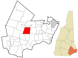
Rockingham County is a county in the U.S. state of New Hampshire. As of the 2020 census, the population was 314,176, making it New Hampshire's second-most populous county. The county seat is Brentwood. Rockingham County is part of the Boston-Cambridge-Newton, MA-NH Metropolitan Statistical Area and the greater Boston-Worcester-Providence, MA-RI-NH-CT Combined Statistical Area. Per the 2020 census, it was New Hampshire's fastest growing county from 2010 to 2020.

<span class="mw-page-title-main">Stewartstown, New Hampshire</span> Town in New Hampshire, United States

Stewartstown is a town in Coös County, New Hampshire, United States. The population was 813 at the 2020 census, down from 1,004 at the 2010 census. It includes the village of West Stewartstown and is part of the Berlin, NH-VT Micropolitan Statistical Area.

<span class="mw-page-title-main">Atkinson, New Hampshire</span> Place in New Hampshire, United States

Atkinson is a town in Rockingham County, New Hampshire, United States. The population was 7,087 at the 2020 census.

<span class="mw-page-title-main">Brentwood, New Hampshire</span> Place in New Hampshire, United States

Brentwood is a town in Rockingham County, New Hampshire, United States. At the 2020 census, its population was 4,490. Brentwood has been the county seat of Rockingham County since 1997.

<span class="mw-page-title-main">Candia, New Hampshire</span> Place in New Hampshire, United States

Candia is a town in Rockingham County, New Hampshire, United States. The population was 4,013 at the 2020 census. The town includes the villages of Candia, Candia Four Corners and East Candia.

<span class="mw-page-title-main">Chester, New Hampshire</span> Town in New Hampshire, United States

Chester is a town in Rockingham County, New Hampshire, United States. The population was 5,232 at the 2020 census, up from 4,768 at the 2010 census. It was home to the now defunct Chester College.

<span class="mw-page-title-main">Danville, New Hampshire</span> Town in New Hampshire, United States

Danville is a town in Rockingham County, New Hampshire, United States. The population was 4,408 at the 2020 census. Danville is part of the Timberlane Regional School District, with students attending Danville Elementary School, Timberlane Regional Middle School, and Timberlane Regional High School.

<span class="mw-page-title-main">Greenland, New Hampshire</span> Place in New Hampshire, United States

Greenland is a town in Rockingham County, New Hampshire, United States. The population was 4,067 at the 2020 census, up from 3,549 at the 2010 census. It is drained by the Winnicut River and bounded on the northwest by Great Bay.

<span class="mw-page-title-main">Hampstead, New Hampshire</span> Place in New Hampshire, United States

Hampstead is a town in Rockingham County, New Hampshire, United States. The population was 8,998 at the 2020 census. Hampstead, which includes the village of East Hampstead, is home to a portion of the Rockingham Recreational Trail.

<span class="mw-page-title-main">Kingston, New Hampshire</span> Place in New Hampshire, United States

Kingston is a town in Rockingham County, New Hampshire, United States. The population at the 2020 census was 6,202.

<span class="mw-page-title-main">Newfields, New Hampshire</span> Place in New Hampshire, United States

Newfields is a town in Rockingham County, New Hampshire, United States. The population was 1,769 at the 2020 census. The primary village in town, where 378 people resided at the 2020 census, is defined as the Newfields census-designated place (CDP) and is located along New Hampshire Route 85 and the Squamscott River. It is a quaint village of handsome old houses.

<span class="mw-page-title-main">Plaistow, New Hampshire</span> Place in New Hampshire, United States

Plaistow is a town in Rockingham County, New Hampshire, United States. The population was 7,830 at the 2020 census.

<span class="mw-page-title-main">Sandown, New Hampshire</span> Town in New Hampshire, United States

Sandown is a town in Rockingham County, New Hampshire, United States. The population was 6,548 at the 2020 census, up from 5,986 at the 2010 census.

<span class="mw-page-title-main">Stratham, New Hampshire</span> Town in New Hampshire, United States

Stratham is a town in Rockingham County, New Hampshire, United States. The town had a population of 7,669 at the 2020 census. It is bounded on the west by the Squamscott River. The town is the home of the only U.S. Lindt & Sprüngli factory and the headquarters of the Timberland Corporation.

<span class="mw-page-title-main">Exeter, New Hampshire</span> Town in New Hampshire, United States

Exeter is a town in Rockingham County, New Hampshire, United States. Its population was 16,049 at the 2020 census, up from 14,306 at the 2010 census. Exeter was the county seat until 1997, when county offices were moved to neighboring Brentwood. Home to Phillips Exeter Academy, a private university-preparatory school, Exeter is situated where the Exeter River becomes the tidal Squamscott River.

<span class="mw-page-title-main">Epping, New Hampshire</span> Place in New Hampshire, United States

Epping is a town in Rockingham County, New Hampshire, United States. The population was 7,125 at the 2020 census, up from 6,411 at the 2010 census.

<span class="mw-page-title-main">Hampton, New Hampshire</span> Place in New Hampshire, United States

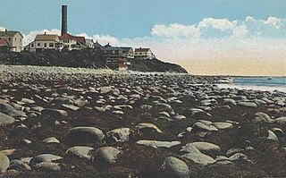
Hampton is a town in Rockingham County, New Hampshire, United States. The population was 16,214 at the 2020 census. On the Atlantic coast, Hampton is home to Hampton Beach, a summer tourist destination.

<span class="mw-page-title-main">Newmarket, New Hampshire</span> Place in New Hampshire, United States

Newmarket is a town in Rockingham County, New Hampshire, United States. The population was 9,430 at the 2020 census. Some residents are students and employees at the nearby University of New Hampshire in Durham.

<span class="mw-page-title-main">Raymond, New Hampshire</span> Place in New Hampshire, United States

Raymond is a town in Rockingham County, New Hampshire, United States. The population was 10,684 at the 2020 census. Part of Pawtuckaway State Park is in the north.

<span class="mw-page-title-main">Fremont Meeting House</span> Historic church in New Hampshire, United States

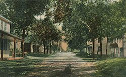
The Fremont Meeting House is a historic meeting house at 464 Main Street in Fremont, New Hampshire. Built in 1800, it is a well-preserved example of a Federal-period meeting house, and is the only surviving example in the state with two porches, a once-common variant of the building type. The building was listed on the National Register of Historic Places in 1993.

References

  1. 1 2 3 "2021 U.S. Gazetteer Files – New Hampshire". United States Census Bureau. Retrieved December 22, 2021.
  2. "Fremont town, Rockingham County, New Hampshire: 2020 DEC Redistricting Data (PL 94-171)". U.S. Census Bureau. Retrieved December 22, 2021.
  3. United States Census Bureau, U.S. Census website, 2010 Census figures. Retrieved March 23, 2011.
  4. Rimkunas, Barbara (June 7, 2013). "Remembering the Mast Tree Riot of 1734". seacoastonline.com. Retrieved January 7, 2024.
  5. Gannett, Henry (1905). The Origin of Certain Place Names in the United States. Govt. Print. Off. pp.  132.
  6. "Fremont, New Hampshire – August 10, 1959". newenglandaviationhistory.com. April 19, 2016. Retrieved June 11, 2022.
  7. 1 2 "ASN Wikibase Occurrence # 48336". Aviation Safety Network . Retrieved June 11, 2022.
  8. "Investigators Seek Cause of B52 Crash". The Portsmouth Herald . Portsmouth, New Hampshire. August 11, 1959. p. 1. Retrieved June 11, 2022 via newspapers.com.
  9. "Crew Of Eight Parachutes To Safety As B52 Crashes". Bangor Daily News . Bangor, Maine. AP. August 11, 1959. p. 1. Retrieved June 11, 2022 via newspapers.com.
  10. Foster, Debra H.; Batorfalvy, Tatianna N.; Medalie, Laura (1995). Water Use in New Hampshire: An Activities Guide for Teachers. U.S. Department of the Interior and U.S. Geological Survey.
  11. "Census of Population and Housing". Census.gov. Retrieved June 4, 2016.
  12. "U.S. Census website". United States Census Bureau . Retrieved January 31, 2008.
  13. "Fremont Historic Facts & Figures". fremont.nh.gov. Retrieved June 11, 2022.
  14. "Fremont Historical Museum". fremont.nh.gov. Retrieved June 11, 2022.