Greenville, New Hampshire

Last updated

Greenville, New Hampshire
Town
Greenville NH Souhegan R.jpg
The Souhegan River in the center of Greenville
Hillsborough-Greenville-NH.png
Coordinates: 42°46′02″N71°48′44″W / 42.76722°N 71.81222°W / 42.76722; -71.81222
Country United States
State New Hampshire
County Hillsborough
Incorporated 1872
Government
   Board of Selectmen Carla C. Mary, Chair
Douglas A. Reardon
Maggie Bickford
  Town AdministratorTara Sousa
Area
[1]
  Total6.9 sq mi (17.8 km2)
  Land6.9 sq mi (17.8 km2)
  Water0.0 sq mi (0.0 km2)
Elevation
830 ft (250 m)
Population
 (2020) [2]
  Total1,974
  Density287/sq mi (110.8/km2)
Time zone UTC-5 (Eastern)
  Summer (DST) UTC-4 (Eastern)
ZIP code
03048
Area code 603
FIPS code 33-31940
GNIS feature ID0873613
Website www.greenvillenh.org

Greenville is a town in Hillsborough County, New Hampshire, United States. The population was 1,974 at the 2020 census, [2] down from 2,105 at the 2010 census. [3] It is located at the junctions of New Hampshire routes 31, 45, and 123.

Contents

History

Print of Greenville from 1886 by L.R. Burleigh with a list of landmarks as well as an inset facsimile of an 1847 rendering of Mason Village Greenville, N.H. (2674998059).jpg
Print of Greenville from 1886 by L.R. Burleigh with a list of landmarks as well as an inset facsimile of an 1847 rendering of Mason Village

Once a part of Mason called "Mason Village", Greenville is one of the state's newest and smallest towns, incorporated in 1872. [4] It is located at the High Falls on the Souhegan River, whose plentiful water power provided the mill town with the state's first industries, making cotton and woolen goods. Because of the falls, Greenville was always a manufacturing center. The Columbian Manufacturing Company was established in 1826 to make textiles in both Greenville and neighboring New Ipswich. [5] The Columbian is long gone, but its fine brick buildings still dominate the village, kept company by Queen Anne style houses on side streets. The mills are now used for other businesses and storage, and one has been converted into housing for the elderly.

Greenville once had a Boston & Maine Railroad trestle. Before it was dismantled for safety reasons, local residents turned out one sunny afternoon to watch Bronson Potter, Mason resident and inventor, fly a private airplane underneath the span on a wager.[ citation needed ] The railroad depot, which still stands, was once an important landmark that put the tiny towns of Mason and Greenville "on the map". It has since been turned into a Chinese restaurant and lounge.

Geography

According to the United States Census Bureau, the town has a total area of 6.9 square miles (17.8 km2), all of it recorded as land. [1] The Greenville CDP, which includes the town center, occupies the northern part of the town and has an area of 3.4 sq mi (8.8 km2). The Souhegan River passes through the town center.

Greenville's highest point is Barrett Hill, near the western border of the town, with an elevation of 1,270 feet (390 m) above sea level. The northern half of the town is drained by the Souhegan River, while the southern half is drained by tributaries of Walker Brook and Mason Brook, which flow south to the Squannacook River, a tributary of the Nashua River in Massachusetts. The entire town is within the Merrimack River watershed. [6]

Adjacent municipalities

Roadways

Four state highways traverse Greenville. NH Route 31 enters the state in Mason from Ashby, Massachusetts, on MA Route 31. NH 31 intersects NH 124 before entering Greenville. NH 31 runs north-south for the entire length of the town before entering Wilton to the north. The highway shares a right-of-way with NH Route 123 which intersects it and runs north to Pleasant Street. Pleasant Street is the main access road to downtown Greenville from NH 31 in the south. NH 123 continues on a left turn in downtown Greenville and runs south to New Ipswich and NH 124. Further down Main Street in Greenville is the beginning of NH Route 45, which runs northwest to Temple, ending at NH Route 101. NH Route 124 crosses the southwest corner of Greenville but intersects no other highways within the town limits.

Climate

According to the Köppen Climate Classification system, Greenville has a warm-summer humid continental climate, abbreviated "Dfb" on climate maps.

Climate data for Greenville, New Hampshire, 1991–2020 normals, extremes 2000–present
MonthJanFebMarAprMayJunJulAugSepOctNovDecYear
Record high °F (°C)65
(18)
70
(21)
79
(26)
92
(33)
92
(33)
100
(38)
104
(40)
104
(40)
100
(38)
94
(34)
80
(27)
76
(24)
104
(40)
Mean maximum °F (°C)54.7
(12.6)
54.5
(12.5)
62.7
(17.1)
76.5
(24.7)
86.6
(30.3)
89.5
(31.9)
91.1
(32.8)
87.7
(30.9)
85.7
(29.8)
74.9
(23.8)
67.3
(19.6)
56.1
(13.4)
92.9
(33.8)
Mean daily maximum °F (°C)30.2
(−1.0)
34.2
(1.2)
41.5
(5.3)
54.7
(12.6)
66.3
(19.1)
74.1
(23.4)
79.4
(26.3)
77.8
(25.4)
70.4
(21.3)
57.9
(14.4)
46.3
(7.9)
35.5
(1.9)
55.7
(13.2)
Daily mean °F (°C)22.3
(−5.4)
24.5
(−4.2)
31.9
(−0.1)
43.8
(6.6)
54.3
(12.4)
62.9
(17.2)
68.8
(20.4)
66.7
(19.3)
59.7
(15.4)
47.8
(8.8)
37.9
(3.3)
27.5
(−2.5)
45.7
(7.6)
Mean daily minimum °F (°C)14.4
(−9.8)
14.8
(−9.6)
22.3
(−5.4)
32.8
(0.4)
42.4
(5.8)
51.7
(10.9)
58.2
(14.6)
55.7
(13.2)
48.9
(9.4)
37.7
(3.2)
29.5
(−1.4)
19.6
(−6.9)
35.7
(2.0)
Mean minimum °F (°C)−4.1
(−20.1)
−1.1
(−18.4)
6.3
(−14.3)
22.1
(−5.5)
31.0
(−0.6)
41.1
(5.1)
48.7
(9.3)
46.4
(8.0)
34.9
(1.6)
25.3
(−3.7)
14.9
(−9.5)
3.3
(−15.9)
−7.0
(−21.7)
Record low °F (°C)−20
(−29)
−16
(−27)
−10
(−23)
10
(−12)
24
(−4)
32
(0)
38
(3)
38
(3)
22
(−6)
10
(−12)
0
(−18)
−10
(−23)
−20
(−29)
Average precipitation inches (mm)3.42
(87)
3.28
(83)
4.25
(108)
4.35
(110)
3.73
(95)
4.26
(108)
3.64
(92)
3.84
(98)
4.25
(108)
5.42
(138)
4.11
(104)
4.96
(126)
49.51
(1,257)
Average snowfall inches (cm)19.2
(49)
19.2
(49)
15.7
(40)
2.9
(7.4)
0.0
(0.0)
0.0
(0.0)
0.0
(0.0)
0.0
(0.0)
0.0
(0.0)
0.4
(1.0)
1.9
(4.8)
16.1
(41)
75.4
(192.2)
Average precipitation days (≥ 0.01 in)9.07.28.69.310.910.59.08.47.99.48.79.2108.1
Average snowy days (≥ 0.1 in)6.15.44.21.20.00.00.00.00.00.21.24.022.3
Source 1: NOAA [7]
Source 2: National Weather Service (mean maxima and minima 20062020) [8]

Demographics

Historical population
CensusPop.Note
1880 1,072
1890 1,25517.1%
1900 1,60828.1%
1910 1,374−14.6%
1920 1,346−2.0%
1930 1,319−2.0%
1940 1,236−6.3%
1950 1,2803.6%
1960 1,3858.2%
1970 1,58714.6%
1980 1,98825.3%
1990 2,23112.2%
2000 2,224−0.3%
2010 2,105−5.4%
2020 1,974−6.2%
U.S. Decennial Census [2] [9]

As of the census of 2010, there were 2,105 people, 861 households, and 537 families residing in the town. There were 933 housing units, of which 72, or 7.7%, were vacant. The racial makeup of the town was 97.0% white, 0.6% African American, 0.5% Native American, 0.1% Asian, 0.2% Native Hawaiian or Pacific Islander, 0.2% some other race, and 1.4% from two or more races. 2.2% of the population were Hispanic or Latino of any race. [10]

Of the 861 households, 30.1% had children under the age of 18 living with them, 42.9% were headed by married couples living together, 13.8% had a female householder with no husband present, and 37.6% were non-families. 29.3% of all households were made up of individuals, and 10.2% were someone living alone who was 65 years of age or older. The average household size was 2.44, and the average family size was 3.02. [10]

In the town, 23.2% of the population were under the age of 18, 8.0% were from 18 to 24, 23.3% from 25 to 44, 32.7% from 45 to 64, and 12.6% were 65 years of age or older. The median age was 41.6 years. For every 100 females, there were 98.6 males. For every 100 females age 18 and over, there were 96.7 males. [10]

For the period 2011–2015, the estimated median annual income for a household was $52,602, and the median income for a family was $63,850. The per capita income for the town was $24,457. 13.8% of the population and 8.6% of families were below the poverty line. 24.9% of the population under the age of 18 and 11.7% of those 65 or older were living in poverty. [11]

Notable people

See also

Related Research Articles

<span class="mw-page-title-main">Hillsborough County, New Hampshire</span> County in New Hampshire, United States

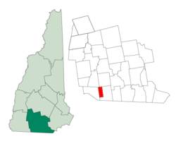
Hillsborough County is the most populous county in the U.S. state of New Hampshire. As of the 2020 census, the population was 422,937, almost one-third the population of the entire state. Its county seats are Manchester and Nashua, the state's two biggest cities. Hillsborough is northern New England's most populous county as well as its most densely populated.

<span class="mw-page-title-main">Gilford, New Hampshire</span> Town in New Hampshire, United States

Gilford is a town in Belknap County, New Hampshire, United States. The population was 7,699 at the 2020 census, up from 7,126 at the 2010 census. Situated on Lake Winnipesaukee, Gilford is home to Governors Island, Ellacoya State Beach, Belknap Mountain State Forest, Gunstock Mountain Resort, and the Bank of New Hampshire Pavilion, a seasonal outdoor concert venue. The lakeside village of Glendale lies within Gilford's borders.

<span class="mw-page-title-main">Errol, New Hampshire</span> Town in New Hampshire, United States

Errol is a town in Coös County, New Hampshire, United States. The population was 298 at the 2020 census. It is located north of the White Mountains along Route 16 at its intersection of Route 26. It has a municipal airport with a single, unpaved runway.

<span class="mw-page-title-main">Northumberland, New Hampshire</span> Town in New Hampshire, United States

Northumberland is a town located in western Coös County, New Hampshire, United States, north of Lancaster. It is part of the Berlin, NH–VT micropolitan statistical area. As of the 2020 census, the town population was 2,126, of whom 1,068 lived in the village of Groveton.

<span class="mw-page-title-main">Amherst, New Hampshire</span> Town in New Hampshire, United States

Amherst is a town in Hillsborough County in the state of New Hampshire, United States. The population was 11,753 at the 2020 census. Amherst is home to Ponemah Bog Wildlife Sanctuary, Hodgman State Forest, the Joe English Reservation and Baboosic Lake.

<span class="mw-page-title-main">Brookline, New Hampshire</span> Town in New Hampshire, United States

Brookline is a town in Hillsborough County, New Hampshire, United States. The population was 5,639 at the 2020 census, up from 4,991 at the 2010 census. Brookline is home to the Talbot-Taylor Wildlife Sanctuary, Potanipo Pond, and the Brookline Covered Bridge.

<span class="mw-page-title-main">Greenfield, New Hampshire</span> Town in New Hampshire, United States

Greenfield is a town in Hillsborough County, New Hampshire, United States. The population was 1,716 at the 2020 census. Greenfield is home to the Crotched Mountain Rehabilitation Center, to Greenfield State Park, and to part of the Wapack Trail.

<span class="mw-page-title-main">Lyndeborough, New Hampshire</span> Town in New Hampshire, United States

Lyndeborough is a town in Hillsborough County, New Hampshire, United States. The population was 1,702 at the 2020 census.

<span class="mw-page-title-main">Mason, New Hampshire</span> Town in New Hampshire, United States

Mason is a town in Hillsborough County, New Hampshire, United States. The population was 1,448 at the 2020 census. Mason, together with Wilton, is home to Russell-Abbott State Forest.

<span class="mw-page-title-main">Merrimack, New Hampshire</span> Town in New Hampshire, United States

Merrimack is a town in Hillsborough County, New Hampshire, United States. The population was 26,632 as of the 2020 census.

<span class="mw-page-title-main">Mont Vernon, New Hampshire</span> Town in New Hampshire, United States

Mont Vernon is a town in Hillsborough County, New Hampshire, United States. The population was 2,584 at the 2020 census, up from 2,409 at the 2010 census.

<span class="mw-page-title-main">New Ipswich, New Hampshire</span> Town in New Hampshire, United States

New Ipswich is a town in Hillsborough County, New Hampshire, United States. The population was 5,204 at the 2020 census. New Ipswich, situated on the Massachusetts border, includes the villages of Bank, Davis, Gibson Four Corners, Highbridge, New Ipswich Center, Smithville, and Wilder, though these village designations no longer hold the importance they did in the past. The Wapack Trail passes through the community.

<span class="mw-page-title-main">Temple, New Hampshire</span> Town in New Hampshire, United States

Temple is a town in Hillsborough County, New Hampshire, United States. The population was 1,382 at the 2020 census. It is home to Temple Mountain State Reservation, formerly the Temple Mountain Ski Area.

<span class="mw-page-title-main">Greenville (CDP), New Hampshire</span> Census-designated place in New Hampshire, United States

Greenville is a census-designated place (CDP) and the main village in the town of Greenville in Hillsborough County, New Hampshire, United States. The population of the CDP was 1,074 at the 2020 census, out of 1,974 in the entire town.

<span class="mw-page-title-main">Milford (CDP), New Hampshire</span> Census-designated place in New Hampshire, United States

Milford is a census-designated place (CDP) and the main village in the town of Milford, Hillsborough County, New Hampshire, United States. The population of the CDP was 9,212 at the 2020 census, out of 16,131 in the entire town.

<span class="mw-page-title-main">Wilton (CDP), New Hampshire</span> Census-designated place in New Hampshire, United States

Wilton is a census-designated place (CDP) and the main village in the town of Wilton, Hillsborough County, New Hampshire, United States. The CDP extends east into the town of Milford as well. The population of the CDP was 1,324 at the 2020 census, up from 1,163 at the 2010 census.

<span class="mw-page-title-main">Wilton, New Hampshire</span> Town in New Hampshire, United States

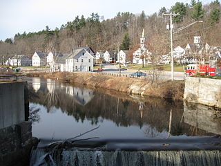
Wilton is a town in Hillsborough County, New Hampshire, United States. The population was 3,896 at the 2020 census. Like many small New England towns, it grew up around water-powered textile mills, but is now a rural bedroom community with some manufacturing and service employment. Wilton is home to the High Mowing School, a private preparatory school.

<span class="mw-page-title-main">Milford, New Hampshire</span> Town in New Hampshire, United States

Milford is a town in Hillsborough County, New Hampshire, United States, on the Souhegan River. The population was 16,131 at the 2020 census, up from 15,115 at the 2010 census. It is the retail and manufacturing center of a multi-town area known informally as the Souhegan Valley.

<span class="mw-page-title-main">New Hampshire Route 31</span> State highway in southern New Hampshire, US

New Hampshire Route 31 is a 56.148-mile-long (90.361 km) north–south state highway in southern New Hampshire. It runs from Mason on the Massachusetts border, where, as Greenville Road, the road becomes Massachusetts Route 31. It passes through Greenville, Wilton, Lyndeborough, Greenfield, Bennington, Antrim, Hillsborough, Windsor, and Washington, reaching its northern terminus of Goshen at New Hampshire Route 10.

<span class="mw-page-title-main">New Hampshire Route 123</span> State highway in southwestern New Hampshire, US

New Hampshire Route 123 is a 63.055-mile-long (101.477 km) secondary north–south state highway in southwestern New Hampshire. The southern terminus of the route is at the Massachusetts state line in Mason where, as Mason Road, the road continues as an unnumbered local road in the town of Townsend. The northern terminus, as signed, is at the Connecticut River, where the highway continues west for 0.313 miles (0.504 km) to U.S. Route 5 in Westminster, Vermont, as Vermont Route 123. Route logs, however, place the terminus at New Hampshire Route 12 in Walpole.

References

  1. 1 2 "2021 U.S. Gazetteer Files – New Hampshire". United States Census Bureau. Retrieved December 7, 2021.
  2. 1 2 3 "Greenville town, Hillsborough County, New Hampshire: 2020 DEC Redistricting Data (PL 94-171)". U.S. Census Bureau. Retrieved December 7, 2021.
  3. United States Census Bureau, U.S. Census website, 2010 Census figures. Retrieved March 23, 2011.
  4. New Hampshire Economic and Labor Market Information Bureau Profile
  5. Coolidge, Austin J.; John B. Mansfield (1859). A History and Description of New England. Boston, Massachusetts: A.J. Coolidge. pp.  574–575. coolidge mansfield history description new england 1859.
  6. Foster, Debra H.; Batorfalvy, Tatianna N.; Medalie, Laura (1995). Water Use in New Hampshire: An Activities Guide for Teachers. U.S. Department of the Interior and U.S. Geological Survey.
  7. "U.S. Climate Normals Quick Access". National Oceanic and Atmospheric Administration. Retrieved August 3, 2022.
  8. "NOAA Online Weather Data". National Weather Service. Retrieved August 3, 2022.
  9. "Census of Population and Housing". Census.gov. Retrieved June 4, 2016.
  10. 1 2 3 "Profile of General Population and Housing Characteristics: 2010 Census Summary File 1 (DP-1): Greenville town, Hillsborough County, New Hampshire". American Factfinder. U.S. Census Bureau. Archived from the original on February 13, 2020. Retrieved November 1, 2017.
  11. "Selected Economic Characteristics: 2011-2015 American Community Survey 5-Year Estimates (DP03): Greenville town, Hillsborough County, New Hampshire". American Factfinder. U.S. Census Bureau. Archived from the original on February 13, 2020. Retrieved November 1, 2017.