Deering, New Hampshire

Last updated

Deering, New Hampshire
Town
Church, Deering, NH.jpg
Deering Community Church (built 1829) c.1903
Deering, NH Town Seal.png
Hillsborough-Deering-NH.png
Coordinates: 43°04′23″N71°50′40″W / 43.07306°N 71.84444°W / 43.07306; -71.84444
CountryUnited States
State New Hampshire
County Hillsborough
Incorporated 1774
Villages
  • Deering
  • East Deering
  • West Deering
  • Holton
Government
   Board of Selectmen
  • Jill Smith, Chair
  • Steve Diers
  • Roy Watson
  Town AdministratorPeter R. Flynn
Area
[1]
  Total31.2 sq mi (80.9 km2)
  Land30.6 sq mi (79.2 km2)
  Water0.7 sq mi (1.7 km2)  2.05%
Elevation
1,083 ft (330 m)
Population
 (2020) [2]
  Total1,904
  Density62/sq mi (24.0/km2)
Time zone UTC-5 (Eastern)
  Summer (DST) UTC-4 (Eastern)
ZIP code
03244
Area code 603
FIPS code 33-17780
GNIS feature ID0873577
Website www.deering.nh.us

Deering is a town in Hillsborough County, New Hampshire, United States. The population was 1,904 at the 2020 census. [2]

Contents

History

First settled about 1765, the town was incorporated on 17 January 1774, by John Wentworth, governor of the Province of New Hampshire. He named it "Deering" after the maiden name of his wife, [3] Frances Deering Wentworth, just as two years earlier he had bestowed Francestown with her first name. Deering had 928 residents when the first census was taken in 1790. By 1859, the population was 890. Its hills and valleys were well suited for agriculture. Industries included two sawmills, one gristmill, and one clothing factory. [4]

Geography

Deering is in northwestern Hillsborough County, bordered by Hillsborough and Henniker to the north, Weare to the east, Francestown to the south, Bennington to the southwest, and Antrim to the west. According to the United States Census Bureau, the town has a total area of 31.2 square miles (80.9 km2), of which 30.6 square miles (79.2 km2) are land and 0.66 square miles (1.7 km2) are water, comprising 2.05% of the town. [1] The highest point in Deering is Clark Summit, just west of the center of town, at 1,570 feet (480 m) above sea level. Deering lies fully within the Merrimack River watershed. [5] The eastern two-thirds of the town are drained by tributaries of the Piscataquog River, which flows east to join the Merrimack in Manchester, while the western third of the town drains to the Contoocook River, which forms the western boundary of the town and flows north to the Merrimack in Penacook.

The town is crossed by State Route 149, connecting Hillsborough to the north with Weare to the east.

Adjacent municipalities

Demographics

Historical population
CensusPop.Note
1790 928
1800 1,24434.1%
1810 1,3639.6%
1820 1,4153.8%
1830 1,227−13.3%
1840 1,124−8.4%
1850 890−20.8%
1860 793−10.9%
1870 722−9.0%
1880 674−6.6%
1890 531−21.2%
1900 486−8.5%
1910 353−27.4%
1920 287−18.7%
1930 32412.9%
1940 36713.3%
1950 3926.8%
1960 345−12.0%
1970 57867.5%
1980 1,04180.1%
1990 1,70764.0%
2000 1,8759.8%
2010 1,9122.0%
2020 1,904−0.4%
U.S. Decennial Census [2] [6]

As of the census of 2010, there were 1,912 people, 740 households, and 534 families residing in the town. The population density was 62.1 inhabitants per square mile (24.0/km2). There were 932 housing units at an average density of 30.3 per square mile (11.7/km2). The racial makeup of the town was 97.0% White, 0.3% African American, 0.2% Native American or Alaska Native, 0.1% some other race, and 1.5% from two or more races. Hispanic or Latino of any race were 1.3% of the population. [7]

Town Hall DeeringNH TownHall.jpg
Town Hall

There were 740 households, out of which 28.4% had children under the age of 18 living with them, 58.9% were headed by married couples living together, 7.3% had a female householder with no husband present, and 27.8% were non-families. 20.1% of all households were made up of individuals, and 6.2% were someone living alone who was 65 years of age or older. The average household size was 2.49, and the average family size was 2.85. [7]

In the town, the population was spread out, with 19.4% under the age of 18, 7.2% from 18 to 24, 26.7% from 25 to 44, 33.2% from 45 to 64, and 13.5% who were 65 years of age or older. The median age was 42.9 years. For every 100 females, there were 107.4 males. For every 100 females age 18 and over, there were 105.1 males. [7]

For the period 2009–2013, the estimated median annual income for a household in the town was $68,281, and the median income for a family was $76,389. Male full-time workers had a median income of $60,114 versus $40,272 for females. The per capita income for the town was $33,042. About 5.4% of families and 9.6% of the population were below the poverty line. [8]

Notable people

Related Research Articles

<span class="mw-page-title-main">Merrimack County, New Hampshire</span> County in New Hampshire, United States

Merrimack County is a county in the U.S. state of New Hampshire. As of the 2020 Census, the population was 153,808, making it the third most populous county in New Hampshire. Its county seat is Concord, the state capital. The county was organized in 1823 from parts of Hillsborough and Rockingham counties, and is named for the Merrimack River. Merrimack County comprises the Concord, NH Micropolitan Statistical Area, which in turn constitutes a portion of the Boston–Worcester–Providence, MA–RI–NH–CT Combined Statistical Area. In 2010, the center of population of New Hampshire was located in Merrimack County, in the town of Pembroke.

<span class="mw-page-title-main">Hillsborough County, New Hampshire</span> County in New Hampshire, United States

Hillsborough County is the most populous county in the U.S. state of New Hampshire. As of the 2020 census, the population was 422,937, almost one-third the population of the entire state. Its county seats are Manchester and Nashua, the state's two biggest cities. Hillsborough is northern New England's most populous county as well as its most densely populated.

<span class="mw-page-title-main">Bennington, New Hampshire</span> Town in New Hampshire, United States

Bennington is a town in Hillsborough County, New Hampshire, United States. The population was 1,501 at the 2020 census.

<span class="mw-page-title-main">East Merrimack, New Hampshire</span> Census-designated place in New Hampshire, United States

East Merrimack is a census-designated place (CDP) in the town of Merrimack, Hillsborough County, New Hampshire, United States. There is no village center named "East Merrimack"; rather, the CDP refers to the region of the town of Merrimack lying east of the F. E. Everett Turnpike, overlapping portions of the villages of Reeds Ferry, Thornton's Ferry, and the center of Merrimack. The population was 5,176 at the 2020 census, up from 4,197 at the 2010 census.

<span class="mw-page-title-main">Francestown, New Hampshire</span> Town in New Hampshire, United States

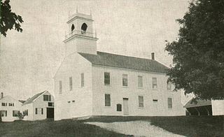
Francestown is a town in Hillsborough County, New Hampshire, United States. The population was 1,610 at the 2020 census. The village of Francestown, population 201 in 2020, is in the center of the town.

<span class="mw-page-title-main">Greenfield, New Hampshire</span> Town in New Hampshire, United States

Greenfield is a town in Hillsborough County, New Hampshire, United States. The population was 1,716 at the 2020 census. Greenfield is home to the Crotched Mountain Rehabilitation Center, to Greenfield State Park, and to part of the Wapack Trail.

<span class="mw-page-title-main">Hancock, New Hampshire</span> Town in New Hampshire, United States

Hancock is a town in Hillsborough County, New Hampshire, United States. The population was 1,731 at the 2020 census. Hancock is home to the Welch Family Farm Forest.

<span class="mw-page-title-main">Lyndeborough, New Hampshire</span> Town in New Hampshire, United States

Lyndeborough is a town in Hillsborough County, New Hampshire, United States. The population was 1,702 at the 2020 census.

<span class="mw-page-title-main">New Boston, New Hampshire</span> Town in New Hampshire, United States

New Boston is a town in Hillsborough County, New Hampshire, United States. The population was 6,108 at the 2020 census, up from 5,321 at the 2010 census. New Boston is home to the annual Hillsborough County Agricultural Fair and the Molly Stark Cannon. The 1743 cannon, which appears on the town seal, was given by General John Stark to the New Boston Artillery Company after the Battle of Bennington.

<span class="mw-page-title-main">Weare, New Hampshire</span> Town in New Hampshire, United States

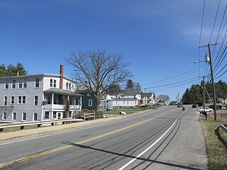
Weare is a town in Hillsborough County, New Hampshire, United States. The population was 9,092 at the 2020 census. It is close to two important New Hampshire cities, Manchester and Concord.

<span class="mw-page-title-main">Dunbarton, New Hampshire</span> Town in New Hampshire, United States

Dunbarton is a town in Merrimack County, New Hampshire, United States. The population was 3,005 at the 2020 census, up from 2,758 at the 2010 census.

<span class="mw-page-title-main">Hopkinton, New Hampshire</span> Town in New Hampshire, United States

Hopkinton is a town in Merrimack County, New Hampshire, United States. The population was 5,914 at the 2020 census. The town has three distinct communities: Hopkinton village, mainly a residential area in the center of the town; Contoocook, the town's business hub, located in the north; and West Hopkinton, within the more agricultural portion of the town. The town is home to the Hopkinton State Fair, adjacent to Contoocook village, and to the historic Contoocook Railroad Depot and the Contoocook Railroad Bridge, the oldest covered railroad bridge in the United States.

<span class="mw-page-title-main">South Hooksett, New Hampshire</span> Census-designated place in New Hampshire, United States

South Hooksett is a census-designated place (CDP) within the town of Hooksett in Merrimack County, New Hampshire, United States. The population was 5,888 at the 2020 census. It is a suburban area adjacent to the city of Manchester, New Hampshire's largest city, and includes a mix of housing developments and large retail stores.

<span class="mw-page-title-main">Antrim, New Hampshire</span> Town in New Hampshire, United States

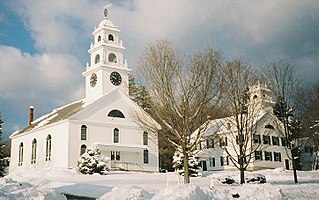
Antrim is a town in Hillsborough County, New Hampshire, United States. The population was 2,651 at the 2020 census. The main village in the town, where 1,395 people lived at the 2020 census, is defined as the Antrim census-designated place (CDP) and is located at the intersection of U.S. Route 202 and New Hampshire Route 31. The town of Antrim also includes the villages of Antrim Center, North Branch, and Clinton Village.

<span class="mw-page-title-main">Hillsborough (CDP), New Hampshire</span> Census-designated place in New Hampshire, United States

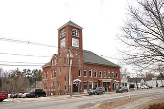
Hillsborough is a census-designated place (CDP) and the main village in the town of Hillsborough in Hillsborough County, New Hampshire, United States. The population of the CDP was 2,156 at the 2020 census, out of 5,939 in the entire town.

<span class="mw-page-title-main">Henniker (CDP), New Hampshire</span> Census-designated place in New Hampshire, United States

Henniker is a census-designated place (CDP) and the main village in the town of Henniker in Merrimack County, New Hampshire, United States. The population of the CDP was 3,166 at the 2020 census, out of 6,185 in the entire town. The CDP is the home to New England College.

<span class="mw-page-title-main">Henniker, New Hampshire</span> Town in New Hampshire, United States

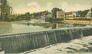
Henniker is a town in Merrimack County, New Hampshire, United States. As of the 2020 census, the reported total population of the town was 6,185, although the figure, 27.9% greater than the 2010 population, has been questioned by local officials. Henniker is home to New England College and Pats Peak Ski Area. Henniker is a college town and resort area, featuring both skiing and white-water kayaking.

<span class="mw-page-title-main">Hillsborough, New Hampshire</span> Town in New Hampshire, United States

Hillsborough, frequently spelled Hillsboro, is a town in Hillsborough County, New Hampshire, United States. The population was 5,939 at the 2020 census. The town is home to Fox State Forest and part of Low State Forest.

<span class="mw-page-title-main">Bennington (CDP), New Hampshire</span> Census-designated place in New Hampshire, United States

Bennington is a census-designated place (CDP) and the main village in the town of Bennington in Hillsborough County, New Hampshire, United States. The population of the CDP was 338 at the 2020 census, out of 1,501 in the entire town.

<span class="mw-page-title-main">Francestown (CDP), New Hampshire</span> Census-designated place in New Hampshire, United States

Francestown is a census-designated place (CDP) and the main village in the town of Francestown, Hillsborough County, New Hampshire, United States. As of the 2020 census, the population of the CDP was 201, out of 1,610 in the entire town.

References

  1. 1 2 "2021 U.S. Gazetteer Files – New Hampshire". United States Census Bureau. Retrieved 6 December 2021.
  2. 1 2 3 "Deering town, Hillsborough County, New Hampshire: 2020 DEC Redistricting Data (PL 94-171)". U.S. Census Bureau. Retrieved 6 December 2021.
  3. Gannett, Henry (1905). The Origin of Certain Place Names in the United States. Govt. Print. Off. pp.  102.
  4. Austin J. Coolidge & John B. Mansfield, A History and Description of New England, Boston, Massachusetts 1859
  5. Foster, Debra H.; Batorfalvy, Tatianna N.; Medalie, Laura (1995). Water Use in New Hampshire: An Activities Guide for Teachers. U.S. Department of the Interior and U.S. Geological Survey.
  6. "Census of Population and Housing". Census.gov. Retrieved 4 June 2016.
  7. 1 2 3 "Profile of General Population and Housing Characteristics: 2010 Census Summary File 1 (DP-1): Deering town, Hillsborough County, New Hampshire". U.S. Census Bureau, American Factfinder. Archived from the original on 16 April 2015. Retrieved 16 April 2015.
  8. "Selected Economic Characteristics: 2009-2013 American Community Survey 5-Year Estimates (DP03): Deering town, Hillsborough County, New Hampshire". U.S. Census Bureau, American Factfinder. Archived from the original on 16 April 2015. Retrieved 16 April 2015.