Washington County, Rhode Island

Last updated

Washington County
Washington County Courthouse (Rhode Island).jpg
Map of Rhode Island highlighting Washington County.svg
Location within the U.S. state of Rhode Island
Rhode Island in United States.svg
Rhode Island's location within the U.S.
Coordinates: 41°27′16″N71°34′52″W / 41.454544°N 71.581154°W / 41.454544; -71.581154
CountryFlag of the United States.svg United States
StateFlag of Rhode Island.svg  Rhode Island
FoundedJune 3, 1729 (Took its current name on October 29, 1781)
Named for George Washington
Seat South Kingstown
Largest townSouth Kingstown
Area
  Total563 sq mi (1,460 km2)
  Land329 sq mi (850 km2)
  Water234 sq mi (610 km2)  41%
Population
 (2020)
  Total129,839 Increase2.svg
  Density830/sq mi (320/km2)
Time zone UTC−5 (Eastern)
  Summer (DST) UTC−4 (EDT)
Congressional district 2nd

Washington County, known locally as South County, is a county located in the U.S. state of Rhode Island. As of the 2020 census, the population was 129,839. [1] Rhode Island counties have no governmental functions other than as court administrative boundaries, which are part of the state government. [2]

Contents

History

The area today known as Washington County was part of the ancestral lands of the Narragansett Indian Tribe. [3] During the second half of the 17th Century, about a dozen English colonists from Newport and Massachusetts colonies moved to the area to establish farms; the larger of these were known as "Narragansett Planters." [3]

By the mid-18th century, there were 25 to 30 large plantations in the county, and their owners became very wealthy. [3] The labor for these farms came from enslaved people; it is estimated that about 15% and 25% of Washington County’s population was enslaved. [3]

Washington County was created as Kings County in 1729 within the Colony of Rhode Island and Providence Plantations. It was renamed Washington County on October 29, 1781, in honor of George Washington. At the earliest stage of colonial settlement, the area was called "The Narragansett Country",[ citation needed ] named after the Naragansett tribe and its tributary tribe the Niantics, both of whom lived in the area.

Early land purchases in the Narragansett Country were effected by settlers after the establishment of Indian trading posts at Fort Neck in Charlestown, and at Smith's Castle in Wickford. A series of conflicts involving the Manisseans on Block Island gave that island to the Massachusetts Bay Colony for a number of years, before being transferred to the Rhode Island Colony under Newport County, and then finally to Washington County in 1959.

The borders of the Narragansett country were disputed for nearly 100 years among the colonies of Rhode Island, Connecticut, and Massachusetts. The Narragansetts had pledged their fealty to King Charles, and the area was known as "The King's Province" and was placed under the authority of Rhode Island "until the King's pleasure was further known". In 1664, a royal commission under Charles II stepped in to adjudicate these conflicting claims. The commission extinguished the claims of Massachusetts, and Rhode Island was granted jurisdiction until the commission finished processing Connecticut's appeals, which were not ended until 1726. Settlements of King's Province were named to reflect the English Restoration, in honor of King Charles II. Towns reflecting this history include the two Kingstowns and Charlestown, as well as the villages of Kingston and West Kingston.

Washington County is also known in Rhode Island as "South County", [4] [5] though some definitions of South County include outside towns, such as East Greenwich in neighboring Kent County, and exclude towns within Washington County, such as New Shoreham. [6]

Geography

Historic Downtown Westerly, Rhode Island Downtown Westerly, RI.jpg
Historic Downtown Westerly, Rhode Island

According to the U.S. Census Bureau, the county has a total area of 563 square miles (1,460 km2), of which 329 square miles (850 km2) is land and 234 square miles (610 km2) (41%) is water. [7] It is the largest county in Rhode Island by total area. The county's topography ranges from flat along the shoreline to gently rolling hills farther inland. The highest point is a large area approximately 560 feet (170 m) above sea level in the Exeter neighborhood of Black Plain; [8] the lowest point is sea level along the coast. The northern boundary west of Davisville is approximately 41.60°N. The western boundary north of Westerly is approximately 71.79°W.

National protected areas

Major highways

Demographics

Historical population
CensusPop.Note
1790 18,323
1800 16,135−11.9%
1810 14,962−7.3%
1820 15,6874.8%
1830 15,411−1.8%
1840 14,324−7.1%
1850 16,43014.7%
1860 18,71513.9%
1870 20,0977.4%
1880 22,49511.9%
1890 23,6495.1%
1900 24,1542.1%
1910 24,9423.3%
1920 24,9320.0%
1930 29,33417.7%
1940 32,49310.8%
1950 48,54249.4%
1960 59,05421.7%
1970 83,58641.5%
1980 93,31711.6%
1990 110,00617.9%
2000 123,54612.3%
2010 126,9792.8%
2020 129,8392.3%
U.S. Decennial Census [9]
1790-1960 [10] 1900-1990 [11]
1990-2000 [12] 2010-2019 [13]

As of the 2010 United States Census, there were 126,979 people, 49,177 households, and 32,297 families residing in the county. [14] The population density was 385.7 inhabitants per square mile (148.9/km2). There were 62,206 housing units at an average density of 188.9 per square mile (72.9/km2). [15] The racial makeup of the county was 93.8% white, 1.6% Asian, 1.2% black or African American, 0.9% American Indian, 0.7% from other races, and 1.8% from two or more races. Those of Hispanic or Latino origin made up 2.4% of the population. [14]

The largest ancestry groups were: [16]

Of the 49,177 households, 28.6% had children under the age of 18 living with them, 52.2% were married couples living together, 9.5% had a female householder with no husband present, 34.3% were non-families, and 26.1% of all households were made up of individuals. The average household size was 2.45 and the average family size was 2.95. The median age was 42.3 years. [14]

The median income for a household in the county was $70,285 and the median income for a family was $87,999. Males had a median income of $59,598 versus $44,851 for females. The per capita income for the county was $34,737. About 3.4% of families and 7.4% of the population were below the poverty line, including 6.3% of those under age 18 and 5.0% of those age 65 or over. [17]

Communities

Map of Washington County, Rhode Island showing towns, census-designated places, and Narragansett tribal lands Map of Washington County Rhode Island With Municipal Labels.PNG
Map of Washington County, Rhode Island showing towns, census-designated places, and Narragansett tribal lands

Towns

Census-designated places

Other villages

Politics

Similar to other counties in Rhode Island, Washington County votes Democratic in presidential elections, having last voted Republican in 1984.

United States presidential election results for Washington County, Rhode Island [18] [19]
Year Republican  /  Whig Democratic Third party
No.%No.%No.%
2020 29,81839.20%44,54958.57%1,6932.23%
2016 27,23041.03%33,74150.84%5,3988.13%
2012 25,36640.34%35,88857.07%1,6252.58%
2008 25,62438.73%39,08259.07%1,4542.20%
2004 26,53342.36%34,67955.37%1,4222.27%
2000 21,25337.80%29,56052.58%5,4119.62%
1996 16,30232.71%25,95852.09%7,57215.20%
1992 16,21130.62%23,00943.46%13,72425.92%
1988 21,65048.04%23,21051.51%2020.45%
1984 24,36557.59%17,79342.06%1470.35%
1980 16,93241.47%16,42940.24%7,46618.29%
1976 17,85649.57%17,98049.91%1860.52%
1972 19,28058.46%13,63741.35%620.19%
1968 11,63943.40%13,85151.65%1,3284.95%
1964 7,34229.63%17,43470.37%00.00%
1960 12,65152.21%11,58047.79%00.00%
1956 14,27865.71%7,45034.29%00.00%
1952 13,38961.29%8,44838.67%90.04%
1948 9,52255.88%7,37943.30%1400.82%
1944 8,23356.12%6,41943.76%180.12%
1940 9,23360.54%6,00139.35%170.11%
1936 8,76458.21%5,95639.56%3362.23%
1932 7,30758.42%5,04740.35%1531.22%
1928 7,79368.84%3,50030.92%270.24%
1924 8,03875.21%2,36622.14%2832.65%
1920 6,42074.93%2,01223.48%1361.59%
1916 2,83755.17%2,22443.25%811.58%
1912 2,12944.91%1,69135.67%92119.43%
1908 3,04366.46%1,27827.91%2585.63%
1904 3,18970.63%1,19726.51%1292.86%
1900 2,42166.35%96026.31%2687.34%
1896 3,04072.05%65415.50%52512.44%
1892 2,18352.83%1,50136.33%44810.84%
1888 2,34657.54%1,49236.60%2395.86%
1884 2,01460.08%1,15534.46%1835.46%
1880 2,01762.02%1,22937.79%60.18%
1852 1,02246.71%1,08649.63%803.66%
1844 96757.59%71242.41%00.00%

See also

Related Research Articles

<span class="mw-page-title-main">Warwick, Rhode Island</span> City in Rhode Island, United States

Warwick is a city in Kent County, Rhode Island, United States, and is the third largest city in the state with a population of 82,823 at the 2020 census. Warwick is located approximately 12 miles (19 km) south of downtown Providence, Rhode Island, 63 miles (101 km) southwest of Boston, Massachusetts, and 171 miles (275 km) northeast of New York City.

<span class="mw-page-title-main">Charlestown, Rhode Island</span> Town in Rhode Island, United States

Charlestown is a town in Washington County, Rhode Island, United States. The population was 7,997 at the 2020 census.

<span class="mw-page-title-main">Exeter, Rhode Island</span> Town in Rhode Island, United States

Exeter is a town in Washington County, Rhode Island, United States. Exeter extends east from the Connecticut border to the town of North Kingstown. It is bordered to the north by West Greenwich and East Greenwich, and to the south by Hopkinton, Richmond, and South Kingstown. Exeter's postal code is 02822, although small parts of the town have the mailing address West Kingston (02892) or Saunderstown (02874). The population was 6,460 at the 2020 census.

<span class="mw-page-title-main">Hopkinton, Rhode Island</span> Place in Rhode Island, United States

Hopkinton is a town in Washington County, Rhode Island. The population was 8,398 at the 2020 census.

<span class="mw-page-title-main">Narragansett, Rhode Island</span> Town in Rhode Island, United States

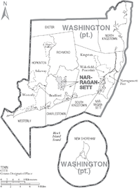
Narragansett is a town in Washington County, Rhode Island, United States. The population was 14,532 at the 2020 census. However, during the summer months the town's population more than doubles to near 34,000. The town of Narragansett occupies a narrow strip of land running along the eastern bank of the Pettaquamscutt River to the shore of Narragansett Bay. It was separated from South Kingstown in 1888 and incorporated as a town in 1901.

<span class="mw-page-title-main">Narragansett Pier, Rhode Island</span> CDP in Rhode Island, United States

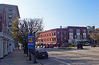
Narragansett Pier is an unincorporated village and a census-designated place (CDP) in the town of Narragansett in Washington County, Rhode Island, United States. The population was 3,409 at the 2010 census.

<span class="mw-page-title-main">North Kingstown, Rhode Island</span> Town in Rhode Island, United States

North Kingstown is a town in Washington County, Rhode Island, United States, and is part of the Providence metropolitan area. The population was 27,732 in the 2020 census. North Kingstown is home to the birthplace of American portraitist Gilbert Stuart, who was born in the village of Saunderstown. Within the town is Quonset Point, location of the former Naval Air Station Quonset Point, known for the invention of the Quonset hut, as well as the historic village of Wickford.

<span class="mw-page-title-main">Richmond, Rhode Island</span> Town in Rhode Island, United States

Richmond is a town in Washington County, Rhode Island. The population was 8,020 at the 2020 census. It contains the villages of Alton, Arcadia, Barberville, Carolina, Hillsdale, Kenyon, Shannock, Tug Hollow, Usquepaug, Wood River Junction, Woodville, and Wyoming. Students in Richmond are part of the Chariho Regional School District.

<span class="mw-page-title-main">South Kingstown, Rhode Island</span> Town in Rhode Island, United States

South Kingstown is a town in, and the county seat of, Washington County, Rhode Island, United States. The population was 31,931 at the 2020 census. South Kingstown is the second largest town in Rhode Island by total geographic area, behind New Shoreham, and the third largest town in Rhode Island by geographic land area, behind Exeter and Coventry.

The Narragansett Council of the Boy Scouts of America serves all of the state of Rhode Island and some of Massachusetts and Connecticut. Its several camps include Camp Yawgoog, Champlin Scout Reservation, and Camp Norse.

<span class="mw-page-title-main">Scouting in Rhode Island</span>

Scouting in Rhode Island has a long history, from the 1910s to the present day, serving thousands of youth in programs that suit the environment in which they live.

<span class="mw-page-title-main">Pawcatuck River</span> River in the U.S. states of Rhode Island and Connecticut

The Pawcatuck River is a river in the US states of Rhode Island and Connecticut flowing approximately 34 miles (55 km). There are eight dams along the river's length. USS Pawcatuck was named after the river.

<span class="mw-page-title-main">Kingston, Rhode Island</span> Census-designated place in Rhode Island, United States

Kingston is a village and a census-designated place within the town of South Kingstown in Washington County, Rhode Island, United States, and the site of the main campus of the University of Rhode Island. The population was 6,974 at the 2010 census. Much of the village center is listed on the National Register of Historic Places as Kingston Village Historic District. It was originally known as Little Rest.

<span class="mw-page-title-main">Rhode Island Route 1A</span> State highway in Washington County, Rhode Island, US

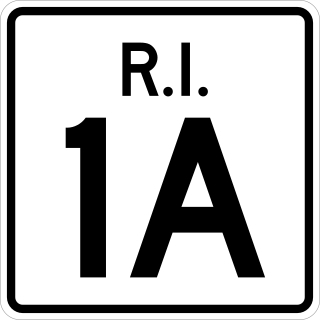
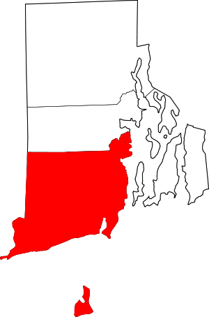
Route 1A, largely signed as Scenic 1A, is a 33.3-mile (53.6 km) long numbered state highway located in Washington County, Rhode Island, United States. The route, which parallels U.S. Route 1 for its entire length, has four distinct sections connected by US 1, two of which require median u-turn ramps to cross US 1. It travels through five towns in Washington County: Westerly, Charlestown, South Kingstown, Narragansett, and North Kingstown.

Chariho is a regional school district located in southern Rhode Island shared by three adjacent towns; Charlestown, Richmond, and Hopkinton. The name Chariho is a portmanteau derived by taking the first two letters from each town name and combining them together. The district operates four elementary schools, two of which are located in Hopkinton, in the villages of Ashaway and Hope Valley, one in Charlestown, and one in Richmond. The Chariho campus located in the Richmond village of Wood River Junction houses the Middle and High Schools, as well as the Chariho Career And Technical Center.

<span class="mw-page-title-main">Rhode Island's 2nd congressional district</span> U.S. House district for Rhode Island

Rhode Island's 2nd congressional district is a congressional district in southern and western Rhode Island. The district is currently represented by Democrat Seth Magaziner, who has represented the district since January 2023.

Sun Publishing Company is a daily and weekly newspaper publisher in southwest Rhode Island and southeast Connecticut, United States. It is a Westerly, Rhode Island-based subsidiary of RISN Operations.

<span class="mw-page-title-main">Carolina, Rhode Island</span> United States historic place

Carolina is a village that straddles the border of the towns of Charlestown and Richmond on the Pawcatuck River in Washington County, Rhode Island. Rhode Island Route 112 passes through the village. Carolina is identified as a census-designated place, with a population of 970 at the 2010 census.

Canonchet is a small village in the town of Hopkinton in the U.S. state of Rhode Island.

Charlestown is a census-designated place (CDP) in Washington County, Rhode Island, United States, comprising the main village in the town of Charlestown and additional land extending to the east into the town of South Kingstown. It was first listed as a CDP prior to the 2020 census.

References

  1. "Census - Geography Profile: Washington County, Rhode Island". United States Census Bureau . Retrieved November 20, 2021.
  2. "National Associations of Counties listing for Washington County, Rhode Island". naco.org. Archived from the original on May 7, 2003. Retrieved May 6, 2018.
  3. 1 2 3 4 "What did southern Rhode Island's Colonial economy look like?". Slavery in Southern Rhode Island. South County History Center. Archived from the original on February 19, 2024. Retrieved February 19, 2024.
  4. "South County isn't an official Rhode Island county. So why does everyone call it that?". The Providence Journal. Retrieved March 26, 2024.
  5. "About South County".
  6. "Towns". South County RI. Retrieved February 27, 2022.
  7. "2010 Census Gazetteer Files". United States Census Bureau. August 22, 2012. Archived from the original on March 4, 2016. Retrieved March 14, 2015.
  8. 41°35′09″N71°39′16″W / 41.58583°N 71.65444°W
  9. "U.S. Decennial Census". United States Census Bureau. Retrieved March 14, 2015.
  10. "Historical Census Browser". University of Virginia Library. Archived from the original on August 11, 2012. Retrieved March 14, 2015.
  11. Forstall, Richard L., ed. (March 27, 1995). "Population of Counties by Decennial Census: 1900 to 1990". United States Census Bureau. Archived from the original on November 9, 2014. Retrieved March 14, 2015.
  12. "Census 2000 PHC-T-4. Ranking Tables for Counties: 1990 and 2000" (PDF). United States Census Bureau. April 2, 2001. Archived (PDF) from the original on December 18, 2014. Retrieved March 14, 2015.
  13. "State & County QuickFacts". United States Census Bureau. Archived from the original on September 3, 2011. Retrieved November 22, 2013.
  14. 1 2 3 "DP-1 Profile of General Population and Housing Characteristics: 2010 Demographic Profile Data". United States Census Bureau. Archived from the original on February 13, 2020. Retrieved January 12, 2016.
  15. "Population, Housing Units, Area, and Density: 2010 - County". United States Census Bureau. Archived from the original on February 13, 2020. Retrieved January 12, 2016.
  16. "DP02 SELECTED SOCIAL CHARACTERISTICS IN THE UNITED STATES – 2006-2010 American Community Survey 5-Year Estimates". United States Census Bureau. Archived from the original on February 13, 2020. Retrieved January 12, 2016.
  17. "DP03 SELECTED ECONOMIC CHARACTERISTICS – 2006-2010 American Community Survey 5-Year Estimates". United States Census Bureau. Archived from the original on February 13, 2020. Retrieved January 12, 2016.
  18. Leip, David. "Dave Leip's Atlas of U.S. Presidential Elections". uselectionatlas.org. Archived from the original on March 23, 2018. Retrieved May 6, 2018.
  19. "The Popular Vote of the United States, in the Presidential Election of 1844" . New York Daily Herald. No. 5270. November 7, 1848. p. 1. Retrieved August 2, 2020 via Newspapers.com.

41°23′N71°37′W / 41.39°N 71.62°W / 41.39; -71.62