Wakefield, New Hampshire

Last updated

Wakefield, New Hampshire
Town
Wakefield Town Hall.jpg
Town Hall
Carroll-Wakefield-NH.png
Coordinates: 43°34′06″N71°01′47″W / 43.56833°N 71.02972°W / 43.56833; -71.02972
Country United States
State New Hampshire
County Carroll
Incorporated 1774
Villages
Government
   Board of Selectmen
  • Mark Duffy
  • Charlie Edwards
  • Kenneth Fifield
  Town AdministratorDino A. Scala
Area
[1]
  Total44.9 sq mi (116.3 km2)
  Land39.6 sq mi (102.6 km2)
  Water5.3 sq mi (13.6 km2)  11.71%
Elevation
680 ft (210 m)
Population
 (2020) [2]
  Total5,201
  Density131/sq mi (50.7/km2)
Time zone UTC-5 (Eastern)
  Summer (DST) UTC-4 (Eastern)
ZIP codes
03830 (East Wakefield)
03872 (Sanbornville)
03887 (Union)
Area code 603
FIPS code 33-78180
GNIS feature ID0873743
Website www.wakefieldnh.com

Wakefield is a town in Carroll County, New Hampshire, United States. The population was 5,201 at the 2020 census. [2] The town includes the villages of Wakefield Corner (the original town center), East Wakefield, North Wakefield, Sanbornville, Union, Woodman and Province Lake. Wakefield Corner, popular with tourists, is a picturesque hilltop village of antique buildings. The state of Maine forms the eastern border of Wakefield.

Contents

History

Initially a native settlement, Wakefield was attacked by John Lovewell during Father Rale's War. Settled later by colonists from Dover and Somersworth, the town was granted in 1749 by John Mason. It was called "East Town" before being incorporated as Wakefield in 1774 by Governor John Wentworth. Wakefield, in Yorkshire, England, is near Wentworth Castle, the home of the Wentworth ancestors.

The New Hampshire town developed as an important sledge and stage stop between the seacoast and the White Mountains. The Wakefield Inn, built in 1804 beside the principal trade route through Wakefield Corner, remains operating today. [3]

Although the soil was considered "stubborn", farmers made it productive. Lumber became a chief product, and by 1859 there were five sawmills, five gristmills, and ten shingle, clapboard and planing mills. Shoemaking was another local industry. [3] When the Portsmouth, Great Falls and Conway Railroad arrived in 1871, [4] the center of Wakefield shifted from Wakefield Corner to Sanbornville, which today remains the retail district of town. [5]

Geography

According to the United States Census Bureau, the town has a total area of 44.9 square miles (116.3 km2), of which 39.6 square miles (102.6 km2) are land and 5.3 square miles (13.6 km2) are water, comprising 11.71% of the town. [1]

Wakefield is at the head of several river systems. The northwestern part of the town is drained by the Pine River, a northwestward-flowing tributary of Ossipee Lake, which flows out to the east as the Ossipee River. Pine River Pond in Wakefield serves as the river's headwaters. The northernmost corner of town is in Province Lake, which drains north into the South River, a tributary of the Ossipee River. Belleau Lake and Balch Pond drain the northeastern part of the town, flowing east into the Little Ossipee River in Maine, another tributary of the Ossipee River. Via the Ossipee, the north half of Wakefield is part of the Saco River watershed. Great East Lake is in the southeastern part of Wakefield, extending into Maine. The lake's outlet is the headwaters of the Salmon Falls River, forming the New Hampshire-Maine boundary, and flowing south into Horn Pond. Lovell Lake, in the south-central part of the town, flows out to the west via the Branch River through Sanbornville. The river then turns south through Union Meadows in the southernmost part of the town, on its way to join the Salmon Falls River in Milton. Via the Salmon Falls, the southern half of Wakefield is part of the Piscataqua River watershed, reaching the Atlantic Ocean at Portsmouth. Of Wakefield's lakes, Province, Balch, Great East, and Horn Pond span the Maine border. The highest point in Wakefield is the summit of Long Mountain, at 1,110 feet (340 m) above sea level, along the town's western border.

Five named villages are within the town limits: Sanbornville, Wakefield village proper ("Wakefield Corner"), East Wakefield, North Wakefield and Union. Sanbornville, the primary settlement in the town, lies at the west end of Lovell Lake, next to the lake's outlet. The village is at the intersection of New Hampshire Routes 109 and 153. Route 16 bypasses the village to the west. Wakefield village occupies a hill just north of Sanbornville on Route 153. The village of Union occupies the southernmost corner of the town, at the intersection of Route 153 and Route 16 (at the northern end of the Spaulding Turnpike). East Wakefield is on Route 153, containing the land east of Pine River Pond and north to the Effingham town line. North Wakefield lies along Route 16 on the west side of Pine River Pond near the town line with Ossipee.

Adjacent municipalities

Demographics

Historical population
CensusPop.Note
1790 646
1800 83529.3%
1810 1,16639.6%
1820 1,51830.2%
1830 1,470−3.2%
1840 1,5968.6%
1850 1,405−12.0%
1860 1,4785.2%
1870 1,185−19.8%
1880 1,39217.5%
1890 1,5289.8%
1900 1,6457.7%
1910 1,543−6.2%
1920 1,335−13.5%
1930 1,186−11.2%
1940 1,158−2.4%
1950 1,2679.4%
1960 1,223−3.5%
1970 1,42016.1%
1980 2,23757.5%
1990 3,05736.7%
2000 4,25239.1%
2010 5,07819.4%
2020 5,2012.4%
U.S. Decennial Census [2] [6]

As of the census [7] of 2000, there were 4,252 people, 1,685 households, and 1,213 families residing in the town. The population density was 108.1 inhabitants per square mile (41.7/km2). There were 3,331 housing units at an average density of 84.7 per square mile (32.7/km2). The racial makeup of the town was 98.21% White, 0.09% African American, 0.45% Native American, 0.19% Asian, 0.19% from other races, and 0.87% from two or more races. Hispanic or Latino of any race were 0.56% of the population.

There were 1,685 households, out of which 31.0% had children under the age of 18 living with them, 60.1% were married couples living together, 8.0% had a female householder with no husband present, and 28.0% were non-families. 21.8% of all households were made up of individuals, and 10.3% had someone living alone who was 65 years of age or older. The average household size was 2.52 and the average family size was 2.92.

In the town, the population was spread out, with 25.7% under the age of 18, 5.2% from 18 to 24, 28.4% from 25 to 44, 25.7% from 45 to 64, and 15.0% who were 65 years of age or older. The median age was 40 years. For every 100 females, there were 97.9 males. For every 100 females age 18 and over, there were 95.2 males.

The median income for a household in the town was $42,500, and the median income for a family was $45,774. Males had a median income of $35,804 versus $24,898 for females. The per capita income for the town was $21,507. About 5.1% of families and 7.1% of the population were below the poverty line, including 8.9% of those under age 18 and 5.8% of those age 65 or over.

Notable people

Related Research Articles

<span class="mw-page-title-main">Poland, Maine</span> Town in the state of Maine, United States

Poland is a town in Androscoggin County, Maine, United States. The population was 5,906 at the 2020 census. Set among rolling hills and numerous lakes, the town is home to Range Ponds State Park, which includes hiking trails and a pristine freshwater beach. Poland is also a historic resort area. It is included in the Lewiston-Auburn, Maine metropolitan statistical area, which itself is part of the Greater Portland-Lewiston Combined Statistical Area.

<span class="mw-page-title-main">Acton, Maine</span> Town in the state of Maine, United States

Acton is a town in York County, Maine, United States. The population was 2,671 at the 2020 census. It includes the villages of Acton, Miller Corner and South Acton. The town is home to the Acton Fairground, which holds the Acton Fair every late summer. It is part of the Portland–South Portland–Biddeford, Maine metropolitan statistical area.

<span class="mw-page-title-main">Cornish, Maine</span> Town in the state of Maine, United States

Cornish is a town in York County, Maine, United States. The population was 1,508 at the 2020 census. It is part of the Portland–South Portland–Biddeford, Maine metropolitan statistical area. The main village in town is the Cornish census-designated place. The village has a number of antique shops and restaurants near historic Thompson Park. Cornish is home to the first concrete bridge in North America.

<span class="mw-page-title-main">Parsonsfield, Maine</span> Town in the state of Maine, United States

Parsonsfield is a town in York County, Maine, United States. The population was 1,791 at the 2020 census. Parsonsfield includes the villages of Kezar Falls, Parsonsfield, and North, East and South Parsonsfield. It is part of the Portland–South Portland–Biddeford, Maine metropolitan statistical area.

<span class="mw-page-title-main">Shapleigh, Maine</span> Town in the state of Maine, United States

Shapleigh, pronounced "SHAP-lee", is a town in York County, Maine, United States which was incorporated as the state's 43rd town in 1785. The population was 2,921 at the 2020 census. Shapleigh is divided into the villages of North Shapleigh, Shapleigh Corner, Ross Corner and Emery Mills. It is part of the Portland–South Portland–Biddeford, Maine metropolitan statistical area.

<span class="mw-page-title-main">Waterboro, Maine</span> Town in Maine, United States

Waterboro is a town in York County, Maine, United States. The population was 7,936 at the 2020 census. It is part of the Portland–South Portland–Biddeford, Maine metropolitan statistical area.

<span class="mw-page-title-main">Effingham, New Hampshire</span> Town in New Hampshire, United States

Effingham is a town in Carroll County, New Hampshire, United States. At the 2020 census, the town population was 1,691, up from 1,465 at the 2010 census. Effingham includes the villages of Effingham Falls, Effingham, Center Effingham, and South Effingham. Pine River State Forest is in the south.

<span class="mw-page-title-main">Moultonborough, New Hampshire</span> Town in New Hampshire, United States

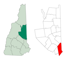
Moultonborough is a town in Carroll County, New Hampshire, United States. The population was 4,918 at the 2020 census, up from 4,044 at the 2010 census. Moultonborough is bounded in large part by Lake Winnipesaukee in the southwest and to a lesser extent by Squam Lake in the northwestern corner. The town includes the census-designated place of Suissevale and the community of Lees Mill.

<span class="mw-page-title-main">Ossipee, New Hampshire</span> Town in New Hampshire, United States

Ossipee is a town in Carroll County, New Hampshire, United States. The population was 4,372 at the 2020 census. It is the county seat of Carroll County. Ossipee, which includes several villages, is a resort area and home to part of Pine River State Forest.

<span class="mw-page-title-main">Tamworth, New Hampshire</span> Town in New Hampshire, United States

Tamworth is a town in Carroll County, New Hampshire, United States. The population was 2,812 at the 2020 census. Tamworth includes the villages of Chocorua, South Tamworth, Wonalancet, and Whittier. The White Mountain National Forest is to the north. The town is home to Hemenway State Forest in the north and White Lake State Park in the southeast.

<span class="mw-page-title-main">Carroll, New Hampshire</span> Town in New Hampshire, United States

Carroll is a town in Coös County, New Hampshire, United States. The population was 820 at the 2020 census. The two largest villages are Twin Mountain and Bretton Woods. Carroll is an important access point for recreational areas in the White Mountains, including many 4,000-footers, the Zealand River area, the Presidential Range, and the Presidential Dry River Wilderness. The town is home to the Mount Washington Hotel at Bretton Woods and to the Highland Center at Crawford Notch, the Appalachian Mountain Club's four-season lodge.

<span class="mw-page-title-main">Errol, New Hampshire</span> Town in New Hampshire, United States

Errol is a town in Coös County, New Hampshire, United States. The population was 298 at the 2020 census. It is located north of the White Mountains along Route 16 at its intersection of Route 26. It has a municipal airport with a single, unpaved runway.

<span class="mw-page-title-main">Canaan, New Hampshire</span> Town in New Hampshire, United States

Canaan is a town in Grafton County, New Hampshire, United States. The population was 3,794 at the 2020 census. It is the location of Mascoma State Forest. Canaan is home to the Cardigan Mountain School, the town's largest employer.

<span class="mw-page-title-main">Holderness, New Hampshire</span> Town in New Hampshire, United States

Holderness is a town in Grafton County, New Hampshire, United States. The population was 2,004 at the 2020 census. An agricultural and resort area, Holderness is home to the Squam Lakes Natural Science Center and is located on Squam Lake. Holderness is also home to Holderness School, a co-educational college-preparatory boarding school.

<span class="mw-page-title-main">Milton, New Hampshire</span> Town in New Hampshire, United States

Milton is a town in Strafford County, New Hampshire, United States. The population was 4,482 at the 2020 census. A manufacturing, resort and residential town, Milton includes the village of Milton Mills. The primary village in town, where 593 people resided at the 2020 census, is defined as the Milton census-designated place (CDP), and is located along New Hampshire Route 125 and the Salmon Falls River, just north of Route 75.

<span class="mw-page-title-main">Wolfeboro (CDP), New Hampshire</span> Census-designated place in New Hampshire, United States

Wolfeboro is a census-designated place (CDP) in the town of Wolfeboro in Carroll County, New Hampshire, United States. It consists of the main village of Wolfeboro within the town, as well as the smaller village of Wolfeboro Falls. The population of the CDP was 3,300 at the 2020 census, out of 6,416 in the entire town of Wolfeboro.

<span class="mw-page-title-main">Wolfeboro, New Hampshire</span> Town in New Hampshire, United States

Wolfeboro is a town in Carroll County, New Hampshire, United States. The population was 6,416 at the 2020 census. A resort area situated beside Lake Winnipesaukee, Wolfeboro includes the village of Wolfeboro Falls.

<span class="mw-page-title-main">New Hampshire Route 153</span> State highway in eastern New Hampshire, US

New Hampshire Route 153 is a 50.566-mile-long (81.378 km) secondary north–south highway in Strafford and Carroll counties in eastern New Hampshire. The southern terminus is in Farmington at New Hampshire Route 11. The northern terminus is in Conway village at New Hampshire Route 16 and New Hampshire Route 113.

<span class="mw-page-title-main">Union, New Hampshire</span> Census-designated place in New Hampshire, United States

Union is a village and census-designated place (CDP) in the town of Wakefield, Carroll County, New Hampshire, United States. It had a population of 196 at the 2020 census.

<span class="mw-page-title-main">Sanbornville, New Hampshire</span> Census-designated place in New Hampshire, United States

Sanbornville is a census-designated place (CDP) and the primary village in the town of Wakefield, Carroll County, New Hampshire, United States. It had a population of 963 at the 2020 census.

References

  1. 1 2 "2021 U.S. Gazetteer Files – New Hampshire". United States Census Bureau. Retrieved November 2, 2021.
  2. 1 2 3 "Wakefield town, Carroll County, New Hampshire: 2020 DEC Redistricting Data (PL 94-171)". U.S. Census Bureau. Retrieved November 2, 2021.
  3. 1 2 Coolidge, Austin J.; John B. Mansfield (1859). A History and Description of New England. Boston, Massachusetts: A.J. Coolidge. pp.  667–668. coolidge mansfield history description new england 1859.
  4. Francis B. C. Bradlee, The Eastern Railroad; The Essex Institute, Salem, Massachusetts 1922
  5. Louis E. Tibbetts, History of Union, New Hampshire (1775–1992)
  6. "Census of Population and Housing". Census.gov. Retrieved June 4, 2016.
  7. "U.S. Census website". United States Census Bureau . Retrieved January 31, 2008.