Rumney, New Hampshire

Last updated

Rumney, New Hampshire
Town
Rumney, NH Town Seal.png
Grafton-Rumney-NH.png
Coordinates: 43°48′15″N71°48′48″W / 43.80417°N 71.81333°W / 43.80417; -71.81333
Country United States
State New Hampshire
County Grafton
Incorporated 1767
Villages
Government
   Board of Selectmen
  • Ed Haskell, Chair
  • Robert Berti
  • Isaac DeWever
  Town AdministratorJoe Chivell
Area
[1]
  Total42.6 sq mi (110.4 km2)
  Land41.7 sq mi (108.0 km2)
  Water0.9 sq mi (2.4 km2)  2.15%
Elevation
509 ft (155 m)
Population
 (2020) [2]
  Total1,498
  Density36/sq mi (13.9/km2)
Time zone UTC-5 (Eastern)
  Summer (DST) UTC-4 (Eastern)
ZIP code
03266
Area code 603
FIPS code 33-65940
GNIS feature ID0873711
Website www.rumneynh.org

Rumney is a town in Grafton County, New Hampshire, United States. The population was 1,498 at the 2020 census. [2] The town is located at the southern edge of the White Mountain National Forest.

Contents

History

Rumney was named after Robert Marsham, 2nd Baron Romney (pronounced Rumney). The town was originally granted in 1761 by Governor Benning Wentworth to settlers from Colchester and East Haddam, Connecticut. It was first settled in 1765; however, some grantees failed to comply with the charter, so Rumney was regranted to another group of settlers in 1767.

Farmers found the town's soil fertile. By 1859, when the population was 1,109, other industries included fifteen sawmills, a large tannery, and a ladder factory. The Boston, Concord and Montreal Railroad commenced service to West Rumney in 1850–1851. [3]

Geography

According to the United States Census Bureau, the town has a total area of 42.6 square miles (110.4 km2), of which 41.7 square miles (108.0 km2) are land and 0.93 square miles (2.4 km2) are water, comprising 2.15% of the town. [1] The highest point in Rumney is 2,960 feet (902 m) above sea level on the southern slope of Carr Mountain. The Baker River flows from west to east through the center of the town, roughly paralleled by New Hampshire Route 25. The town is part of the Pemigewasset River watershed, leading to the Merrimack River.

The town of Rumney contains several smaller villages. Rumney village, the town's central settlement, lies just north of the Baker River. Directly to the south, across the Baker River and adjacent to Route 25, is the village of Rumney Depot. The village of Stinson Lake, comprising development around the lake of the same name and at the foot of adjacent Stinson Mountain, is in the northern corner of the town, and West Rumney is located along Route 25 near the town's western border.

Rumney is home to Polar Caves Park, which is well known for its geological views and glowing rock formations. It is located along Route 25 near the town's eastern border.

Rumney Rocks

Rumney Rocks, located between Rumney village and West Rumney, is a rock climbing destination renowned for its sport climbing routes. [4]

The majority of the climbing is found on the numerous small cliff faces on the south face of Rattlesnake Mountain, much of which lies within the White Mountain National Forest. These cliffs are mostly made of schist, with some being granite, and vary from long smooth slabs to wildly overhung roofs and aretes. They range in height, with most falling between 40 and 90 feet (12 and 27 m), but a few reach over 300 feet (91 m).

Most climbs are well bolted, with a few requiring additional protection. The climbs range from 5.0 to 5.15a, with the majority of routes falling between 5.10 and 5.12. [5]

Demographics

Historical population
CensusPop.Note
1790 411
1800 62451.8%
1810 76522.6%
1820 86412.9%
1830 99314.9%
1840 1,11011.8%
1850 1,109−0.1%
1860 1,103−0.5%
1870 1,1655.6%
1880 1,056−9.4%
1890 947−10.3%
1900 837−11.6%
1910 8501.6%
1920 9117.2%
1930 858−5.8%
1940 8610.3%
1950 859−0.2%
1960 820−4.5%
1970 8706.1%
1980 1,21239.3%
1990 1,44619.3%
2000 1,4802.4%
2010 1,4800.0%
2020 1,4981.2%
U.S. Decennial Census [2] [6]

As of the census [7] of 2000, there were 1,480 people, 569 households, and 393 families residing in the town. The population density was 35.3 inhabitants per square mile (13.6/km2). There were 879 housing units at an average density of 21.0 per square mile (8.1/km2). The racial makeup of the town was 98.04% White, 0.41% African American, 0.54% Native American, 0.41% Asian, 0.07% Pacific Islander, 0.20% from other races, and 0.34% from two or more races. Hispanic or Latino of any race were 0.61% of the population.

There were 569 households, out of which 29.9% had children under the age of 18 living with them, 57.5% were married couples living together, 6.3% had a female householder with no husband present, and 30.8% were non-families. 23.2% of all households were made up of individuals, and 8.8% had someone living alone who was 65 years of age or older. The average household size was 2.55 and the average family size was 3.00.

In the town, the population was spread out, with 25.4% under the age of 18, 5.5% from 18 to 24, 25.9% from 25 to 44, 27.0% from 45 to 64, and 16.1% who were 65 years of age or older. The median age was 41 years. For every 100 females, there were 102.7 males. For every 100 females age 18 and over, there were 102.2 males.

The median income for a household in the town was $38,125, and the median income for a family was $42,895. Males had a median income of $26,594 versus $21,705 for females. The per capita income for the town was $17,169. About 4.9% of families and 9.5% of the population were below the poverty line, including 15.0% of those under age 18 and 6.7% of those age 65 or over.

Stereographic cards c.1880

Notable people

New Hampshire historical marker for the Baker River Baker River Historic Marker.JPG
New Hampshire historical marker for the Baker River

Sites of interest

See also

Related Research Articles

<span class="mw-page-title-main">Gilford, New Hampshire</span> Town in New Hampshire, United States

Gilford is a town in Belknap County, New Hampshire, United States. The population was 7,699 at the 2020 census, up from 7,126 at the 2010 census. Situated on Lake Winnipesaukee, Gilford is home to Governors Island, Ellacoya State Beach, Belknap Mountain State Forest, Gunstock Mountain Resort, and the Bank of New Hampshire Pavilion, a seasonal outdoor concert venue. The lakeside village of Glendale lies within Gilford's borders.

<span class="mw-page-title-main">Brookfield, New Hampshire</span> Town in New Hampshire, United States

Brookfield is a town in Carroll County, New Hampshire, United States. The population was 755 at the 2020 census.

<span class="mw-page-title-main">Effingham, New Hampshire</span> Town in New Hampshire, United States

Effingham is a town in Carroll County, New Hampshire, United States. At the 2020 census, the town population was 1,691, up from 1,465 at the 2010 census. Effingham includes the villages of Effingham Falls, Effingham, Center Effingham, and South Effingham. Pine River State Forest is in the south.

<span class="mw-page-title-main">Wakefield, New Hampshire</span> Town in New Hampshire, United States

Wakefield is a town in Carroll County, New Hampshire, United States. The population was 5,201 at the 2020 census. The town includes the villages of Wakefield Corner, East Wakefield, North Wakefield, Sanbornville, Union, Woodman and Province Lake. Wakefield Corner, popular with tourists, is a picturesque hilltop village of antique buildings. The state of Maine forms the eastern border of Wakefield.

<span class="mw-page-title-main">Marlow, New Hampshire</span> Town in New Hampshire, United States

Marlow is a town in Cheshire County, New Hampshire, United States. The population was 749 at the 2020 census. Marlow is home to Honey Brook State Forest.

<span class="mw-page-title-main">Columbia, New Hampshire</span> Town in New Hampshire, United States

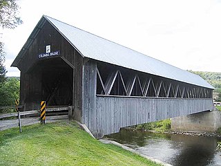
Columbia is a town in Coös County, New Hampshire, United States. The population was 659 at the 2020 census, down from 757 at the 2010 census. It is part of the Berlin, NH-VT micropolitan statistical area.

<span class="mw-page-title-main">Errol, New Hampshire</span> Town in New Hampshire, United States

Errol is a town in Coös County, New Hampshire, United States. The population was 298 at the 2020 census. It is located north of the White Mountains along Route 16 at its intersection of Route 26. It has a municipal airport with a single, unpaved runway.

<span class="mw-page-title-main">Northumberland, New Hampshire</span> Town in New Hampshire, United States

Northumberland is a town located in western Coös County, New Hampshire, United States, north of Lancaster. It is part of the Berlin, NH–VT micropolitan statistical area. As of the 2020 census, the town population was 2,126, of whom 1,068 lived in the village of Groveton.

<span class="mw-page-title-main">Benton, New Hampshire</span> Town in New Hampshire, United States

Benton is a town in Grafton County, New Hampshire, United States. The population was 374 at the 2020 census. Located in the White Mountains, Benton is largely surrounded by the White Mountain National Forest. The town is crossed by the Appalachian Trail.

<span class="mw-page-title-main">Campton, New Hampshire</span> Town in New Hampshire, United States

Campton is a town in Grafton County, New Hampshire, United States. The population was 3,343 at the 2020 census. Campton, which includes the villages of Blair, Campton Hollow, Lower Campton and West Campton, is home to Blair State Forest and Livermore Falls State Forest. It is located in the foothills of the White Mountains, and parts of the White Mountain National Forest are in the northeast and northwest.

<span class="mw-page-title-main">Dorchester, New Hampshire</span> Town in New Hampshire, United States

Dorchester is a town in Grafton County, New Hampshire, United States. The population was 339 at the 2020 census.

<span class="mw-page-title-main">Ellsworth, New Hampshire</span> Town in New Hampshire, United States

Ellsworth is a town in Grafton County, New Hampshire, United States. The population was 93 at the 2020 census.

<span class="mw-page-title-main">Groton, New Hampshire</span> Town in New Hampshire, United States

Groton is a town in Grafton County, New Hampshire, United States. The population was 569 at the 2020 census.

<span class="mw-page-title-main">Orange, New Hampshire</span> Town in New Hampshire, United States

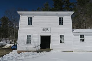
Orange is a town in Grafton County, New Hampshire, United States. The population was 277 at the 2020 census, down from 331 at the 2010 census.

<span class="mw-page-title-main">Warren, New Hampshire</span> Town in New Hampshire, United States

Warren is a town in Grafton County, New Hampshire, United States. The population was 825 at the 2020 census, down from 904 at the 2010 census. Warren includes the village of Glencliff. The Appalachian Trail crosses the town in the west.

<span class="mw-page-title-main">Greenfield, New Hampshire</span> Town in New Hampshire, United States

Greenfield is a town in Hillsborough County, New Hampshire, United States. The population was 1,716 at the 2020 census. Greenfield is home to the Crotched Mountain Rehabilitation Center, to Greenfield State Park, and to part of the Wapack Trail.

<span class="mw-page-title-main">Epsom, New Hampshire</span> Town in New Hampshire, United States

Epsom is a town in Merrimack County, New Hampshire, United States. The population was 4,834 at the 2020 census.

<span class="mw-page-title-main">Salisbury, New Hampshire</span> Town in New Hampshire, United States

Salisbury is a town in Merrimack County, New Hampshire, United States. The population was 1,422 at the 2020 census.

<span class="mw-page-title-main">New Durham, New Hampshire</span> Town in New Hampshire, United States

New Durham is a town in Strafford County, New Hampshire, United States. The population was 2,693 at the 2020 census. It is drained by the Merrymeeting, Cocheco and Ela rivers, and is known for Merrymeeting Lake. New Durham is home to the Powder Mill Fish Hatchery, located on Merrymeeting Road. Also located here is the Lions Club's Camp Pride, a camp for children and adults with special needs.

<span class="mw-page-title-main">Wentworth, New Hampshire</span> Town in New Hampshire, United States

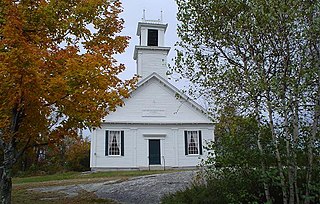
Wentworth is a town in Grafton County, New Hampshire, United States. The population was 845 at the 2020 census, down from 911 at the 2010 census. The town is home to Plummer's Ledge Natural Area, and part of the White Mountain National Forest is in the northeast. The town has a picturesque common, presided over by a Federal-style church and bordered by antique homes.

References

  1. 1 2 "2021 U.S. Gazetteer Files – New Hampshire". United States Census Bureau. Retrieved November 30, 2021.
  2. 1 2 3 "Rumney town, Grafton County, New Hampshire: 2020 DEC Redistricting Data (PL 94-171)". U.S. Census Bureau. Retrieved November 30, 2021.
  3. Coolidge, Austin J.; John B. Mansfield (1859). A History and Description of New England. Boston, Massachusetts: A.J. Coolidge. p.  638. coolidge mansfield history description new england 1859.
  4. "Basic Rock Climbing Rumney Rocks". REI . Retrieved May 8, 2008.
  5. "Rumney". rockclimbing.com. Retrieved July 6, 2009.
  6. "Census of Population and Housing". Census.gov. Retrieved June 4, 2016.
  7. "U.S. Census website". United States Census Bureau . Retrieved January 31, 2008.