Colchester, Connecticut

Last updated

Colchester, Connecticut
Town of Colchester
Colchester, Connecticut, historic sign 01.jpg
Town of Colchester historical marker
ColchesterCTSeal.png
New London County Connecticut Incorporated and Unincorporated areas Colchester Highlighted 2010.svg
Colchester, Connecticut
Coordinates: 41°34′33.4″N72°19′56.3″W / 41.575944°N 72.332306°W / 41.575944; -72.332306
CountryFlag of the United States.svg  United States
U.S. state Flag of Connecticut.svg  Connecticut
County New London
Region Southeastern CT
Incorporated1698 / 1699
Government
  Type Selectman–town meeting
   First Selectman Bernard Dennler
Area
  Total49.8 sq mi (129.0 km2)
  Land49.1 sq mi (127.1 km2)
  Water0.7 sq mi (1.9 km2)
Elevation
551 ft (168 m)
Population
 (2020)
  Total15,555
  Density310/sq mi (120/km2)
Time zone UTC-5 (Eastern)
  Summer (DST) UTC-4 (Eastern)
ZIP Codes
06415, 06420
Area code(s) 860/959
FIPS code 09-15910
GNIS feature ID0213409
Website www.colchesterct.gov
Colchester Village HD - Civil War monument.jpg
Civil War monument on the Green (1875)
Colchester Federated Church, Connecticut.jpg
Colchester Federated Church
Cragin Memorial Library, Colchester, Connecticut.jpg
Cragin Memorial Library

Colchester is a town in New London County, Connecticut, United States. The town is part of the Southeastern Connecticut Planning Region. The population was 15,555 at the 2020 census. [1] In 2010 Colchester became the first town in Connecticut, and the 36th in the country, to be certified with the National Wildlife Federation as a Community Wildlife Habitat.

Contents

The villages of Westchester and North Westchester are located within Colchester. The town center village, which was previously incorporated as a borough, is a census-designated place, with a population of 4,700 at the 2020 census. [2]

The Colchester area was part of the Mohegan territory at the time of European settlement. Several members of the Paugussett tribe currently reside in Colchester, where the tribe (which also has a heritage property in Trumbull) has a larger more recently acquired second 106-acre (0.43 km2) reservation. [3]

The Colchester Historical Society operates a local history museum in town.

History

Pre-Township and Becoming a Township

On March 31, 1661, the original settlement of Colchester, was founded by Jeremy Adams upon a 340-acre area of land known as "Jerimiah's Farme". The land was given to Jeremy, by Uncas, Sachem of the Mohegan tribe. [4]

Colchester's land stayed under the ownership of Jeremy Adams and was not incorporated into any new county in 1666 (when Connecticut's first counties were created) [5] this is likely because of the closeness between both Hartford County and New London County. Colchester was mainly a farming community with Jeremy Adams raising cattle within the town. The abundance of farms in early Colchester is the reason Colchester is "A Right To Farm Community" in the present day. [6] Colchester stayed as a farming community not within a county's borders until 1698.

On October 13, 1698, Michael Taintor II, Samuel Northam and Nathaniel Foote III applied to go forth and settle the Town. [7] [8] Jerimiah's Farme was selected as the main point of reference for the town, with its north boundary as the Twenty Mile River. The southern side is bordered by Lyme. The west boundary meets the east bounds of Middletown and Haddam. The east and northeast boundary run to the bounds of Lebanon and Norwich. During the initial settlement, the area was also referred to as the Plantation of the Twenty-mile River. [9]

On May 11, 1699, the town's principal founders, Nathaniel Foote, Samuel Northam and Michael Taintor asked the general court of Hartford for assistance with persons hindering the advancement of the settlement [9] (Saybrook residents specifically [8] ), to be transferred under the jurisdiction of the New London colony, and for the Town to be recognized as Colchester. On May 11, 1699 [7] the town name was named and incorporated into the colony of New London. After Colchester Officially became a town the land was divided among the original settlers and their ancestors. The town is said to be named after Colchester, [10] a borough and port in Essex, England, where many colonists had emigrated from, most notably, where Nathaniel's grandfather Nathaniel Foote was born.

The 1700s

Nathaniel Foote and his family were some of the first to settle here and finished building their house in 1702. [11] The house began construction in 1699 by Nathaniel Foote III and was then finished by his son Nathaniel Foote IV. [11] On November 29, 1703, [8] a saw and grist mill were voted to be built by Israel and Samual Wyatt if they promised to maintain the mill for the town's use. [12] The first schoolmaster began operations in 1705, and a schoolhouse was finished in 1711. [12] In 1707 or earlier, a cemetery was built behind where Bacon Academy would later be built. [13] The cemetery later held people like Reverend John Bulkeley, Dr. John Watrous, Pierpont Bacon, and his wife, Abigail Bacon. In 1708 Colchester re-joined Hartford county, [5] and a second religious meeting house was built. [8] On December 31, 1712, at a legal town meeting held in Colchester, Capt Gilbert Wyatt and Mr. Darnell Clark were Chosen, Selectmen. [12] On December 28, 1713, Samuel Northam, Thomas Day, and Ebenezer Colman were chosen for a school committee ensuing year. [12]

At a town meeting on June 12, 1716, it was voted to finish the schoolhouse where the foundation of the said house was the only partly standing. [12] The selectmen Committee for the school has agreed with Nathaniel Loomis Jr. (He and his family are from Windsor [8] ) to keep school for twelve months and give him twenty-five pounds and ten shillings. He began to keep building the school. On December 8, 1729, Ensign Foote, Ensign Wells, and Israel Newton were chosen as Selectmen. The constables were selected at the same meeting, being Joseph Chamberlain and Isaac Jones. [12] On June 3, 1774, Stephen Goodwin wrote to the Hartford Courant that he had a runaway slave. The slave was named Jefferey and rode away on horseback. A reward was said to be given out if said horse or Jefferey was found (6 dollars for Jeffery and 4 for the horse).

In 1756 Colchester's population was 2,300 people. In 1761 Michael Taintor built Taintors Farm, which stayed in the family until the early 20th century. [11] The Nathaniel Hayward house was built in 1775 for Dudley Wright; [11] The house was lived in by Dr. John Watrous and his wife (who was Dudley Wright's daughter). The house was later sold in 1848 and lived in by Nathaniel Hayward. The lawn of this house was the original town green. In 1777 Breed's Tavern was built, which is most known for being one of the two remaining sites associated with the Wooster Masonic Lodge. [11] In 1782 Colchester had 3,300 inhabitants. [14] Several men went into the revolutionary war, many of them died. One of which was Ephraim Little Jr., son of the 2nd Reverend of Colchester. In 1783 Colchester rejoined New London County after being within Hartford County. [5] On Thursday, January 29, 1784, Congress suggested a tax, and the representatives of Colchester (Capt. Buckley and Col. Worthington) voted not to have it go into effect. In 1785 the Foote Family house was built by Nathaniel Foote and was lived in by his family. The Henry Champion House was built in 1790 by architect William Sprat. for Colonel Henry Champion who was active in the revolution and a military figure. [11]

A list of the freemen of the town

of Colchester in 1730 — Michael Taintor, Michael Taintor Junior, James Newton, Samuel Northam, Thorn Day, Richard Carrier, Ebeneezer Skinner, Daniel Clark, Daniel Clark Junior, Israel Wyatt, Decon Loomis, Wm Roberts, Nathaniel Loomis, Josh Wright, Josiah Gillet, Josiah Gillet Junior, Ebeneezer Dibell, Capt Gilbert John Adams, John Adams Junior, Decon Skiner, Richard Skinner, Nathaniel Skinner, Benjamin Skinner, Josh Prat, Nathaniell Kellogg, Ephrem Foot, Jos Pumery, Thorn Brown, Noah Wells, Josh Chamberlin, Josiah Foote, James Mun, Ensign John Skinner, Ebeneezer Kellogg, James Brown, Andrew Carrier, Richard Church, Mr Bulkley John Day, Jonathan Gillet, Jonathan Kellogg, Nathaniel Foote, Ebeneezer Coleman, Charles Williams, Clement Cithophell, John Chapman, Senior Ephream Wells, Josiah Phelps, John Holms, William Roberts, Josiah Gates, Joseph Foote and John Johnson [12]

The 1800s

On October 13, 1803, the town of Marlborough, Hartford County was created from parts of the towns of Colchester, Glastonbury, Hartford County, and Hebron, Tolland County. [5] In the 1807 election for governor of Connecticut, Colchester voted 105 for Trumbull and 12 for Hart, a majority for Trumbull. [15] On May 27, 1807, heavy cattle losses were reported because of stray dogs biting them. [15] The following year (1808), Colchester voted for Trumbull’s re-election (135 to 24). In 1810 Colchester voted for the governor, 82 for Treadwell, 61 for Griswold, and 16 for Spalding. [15] On March 6, 1821, John Turner sold the southern green to Bacon Academy Trustees for $100 ($2,800 in 2018). [15] A hatter came in 1828. [14] In 1836, a town description was written in "Connecticut Historical Collections" stating that excellent quality iron ore was found. Colchester was hilly and stony in some parts of town. Hebron’s furnaces later used the ore in 1899. In "Connecticut Historical Collections" the school for colored children is mentioned; considering this book was released in 1836, the school could not have been more than 43 years old. Unbeknownst to John Barber (the writer of this book), he got to see it only four years before its ending. On August 8, 1844, Special Park Committee meeting reported costs to acquire 3+12 acres of land plus costs of posts and rails to line the perimeter for $398 (about $13,000).  

In March 1850, The borough petitioned for a special meeting for land donation by Nathaniel Hayward. His proposal was a donation of land if the borough laid a tax of $1,000 to defray expenses of fences and grading land (about $32,000). [15] The proposal was approved. In 1851 Work was completed for the new Town Park. The borough passes ordinances to ban cows from the park. [15] Borough records showed the town immediately designated the park as a source of income. This included land rental for circus, shows, and sales of grasses and hay. [15]

Colchester Bank

The first known mention of the bank, was on June 19, 1856, when the Senate agreed to pass a bill incorporating the bank. [15] On October 11, 1856, the bank's stockholders met and decided on a board of directors. They are as follows, Albert B. Isham, Stephen Brainard Day (Isaac's Buell's brother), William G. Buell, and Samuel F. Jones Jr. (who would later be the main accomplice in the Colchester bank scandal [16] ). [15] In the same meeting, Isaac Biglow Buell (the cousin of Harvey Post Buell, a successful druggist, and pharmacist in Colchester [17] ) was chosen as president. The bank reportedly began the same day. [15]

The 1900s

The Great New England Hurricane of 1938

On September 21 and 22, 1938, Colchester was slammed by a hurricane. The state of Connecticut was inundated with between 5-10 inches of rain and wind gusts of anywhere from 100–125 miles per hour. Reportedly, the Colchester Town Green resembled a "small lake with cascading streams"

At the time, the town had a number of Dutch Elm trees that were planted in 1850. While the root systems of Dutch elms are extensive, they are also quite shallow. As the hurricane hit on September 21, the shallow root systems were ineffective at keeping the trees rooted in the already saturated ground. These trees fell on many buildings, vehicles, and power lines across town. This blocked roads and left many people without homes. [18]

The 2000s

In August 2000, there was a resident at Dubln Village that had been letting his animals roam, but by this time had "gotten better about monitoring the animals". This same resident was also said to have been "offensive to other residents" by "exposing himself at his front door". [19]

In July 2005, Colchester was named by CNN's Money Magazine, the 57th best place in the U.S. to live in and is celebrated every year with a festival on the last Saturday of September called 57 Fest. [20]

Geography

According to the United States Census Bureau, the town has a total area of 49.8 square miles (129 km2), of which 49.1 square miles (127 km2) is land and 0.7 square miles (1.8 km2), or 1.49%, is water. Among the many waterways are the Salmon River, Jeremy River, and Dickinson Creek, which is spanned by the Lyman Viaduct.

Principal communities

Climate

This climatic region is typified by large seasonal temperature differences, with warm to hot (and often humid) summers and cold (sometimes severely cold) winters. According to the Köppen Climate Classification system, Colchester has a humid continental climate, abbreviated "Dfb" on climate maps. [21]

Activities

The Salmon River State Forest provides opportunities for fishing, hiking, and hunting.

Landmarks

Print made about 1848-1849 by Kelloggs & Comstock KelloggsSteamworksColchester.jpg
Print made about 1848–1849 by Kelloggs & Comstock
Lyman Viaduct on the Air-Line Railroad Lyman viaduct pacific railway 1876.JPG
Lyman Viaduct on the Air-Line Railroad

Formerly an incorporated borough, the town center of Colchester is listed on the National Register of Historic Places as a historic district, known as the Colchester Village Historic District. The walkable center includes a town green with a veterans' memorial. Retail stores and restaurants are located here.

Schools

Colchester has four schools: Colchester Elementary School (Pre K-2), Jack Jackter Intermediate School (Grades 3–5), William J. Johnston Middle School (Grades 6–8), Bacon Academy (Grades 9–12).

Demographics

Historical population
CensusPop.Note
1800 3,163
1820 2,152
1850 2,468
1860 2,86216.0%
1870 3,38318.2%
1880 2,974−12.1%
1890 2,9880.5%
1900 1,991−33.4%
1910 2,1407.5%
1920 2,050−4.2%
1930 2,1344.1%
1940 2,3389.6%
1950 3,00728.6%
1960 4,64854.6%
1970 6,60342.1%
1980 7,76117.5%
1990 10,98041.5%
2000 14,55132.5%
2010 16,06810.4%
2020 15,555−3.2%
U.S. Decennial Census [22]
The Colchester Congregational Church, Bacon Academy, and, to the right of the church beneath the trees, a small "school for colored children." Sketch by John Warner Barber for his Historical Collections of Connecticut (published in 1836) BarberJohnWarnerBaconColchester.jpg
The Colchester Congregational Church, Bacon Academy, and, to the right of the church beneath the trees, a small "school for colored children." Sketch by John Warner Barber for his Historical Collections of Connecticut (published in 1836)

Population [23]

Population, 2020-2022
CategoryDateStatistic
Population EstimatesJuly 1, 202215,572
Population estimates baseApril 1, 202015,547
Population, percent changeApril 1, 2020- July 1, 2022+0.2%
Age and Sex, 2020
CategoryStatistic
Persons under 5 years, percent7.9%
Persons under 18 years, percent23.6%
Persons 65 years and over, percent16.9%
Female persons, percent49.2%
Race & Hispanic Origin, 2020
CategoryStatistic
White alone, percent92.3%
Two or More Races, percent3.0%
Black or African American alone, percent2.2%
Asian alone, percent1.3%
American Indian and Alaska Native alone, percent0.0%
Native Hawai'ian and Other Pacific Islander alone, percent0.0%
Hispanic or Latino, percent3.0%
White alone, not Hispanic or Latino, percent90.9%
Population Characteristics, 2018-2022
CategoryStatistic
Veterans997
Foreign born persons, percent5.0%
Housing, 2018-2022
CategoryStatistic
Owner-occupied housing unit rate80%
Median value of owner-occupied housing units$315,500
Median selected montly owner costs -with a mortgage$2,233
Median selected monthly owner costs -without a mortgage$925
Median gross rent$1,276
Families & Living Arrangements, 2018-2022
CategoryStatistic
Households6,089
Persons per household2.52
Living in the same house 1 year ago, percent of persons age 1 year+88.7%
Language other than English spoken at home, percent of persons age 5 years+5.5%
Computer and Internet Use, 2018-2022
CategoryStatistic
Households with a computer, percent93.8%
Households with a broadband Internet subscription, percent92.3%
Education, 2018-2022, age 25 years+
CategoryStatistic
High school graduate or higher95.9%
Bachelor's degree or higher45.8%
Health, people under age 65 years
CategoryTimeframeStatistic
Persons with a disability2018-20226.5%
Persons without health insurance20201.1%
In Civilian Labor Force, 2018-2022
CategoryStatistic
Total percent of population age 16+69.3%
Female percent of population age 16+64.7%
Transportation, 2018-2022
CategoryStatistic
Mean travel time to work, workers age 16 years+32.4 minutes
Income & Poverty
CategoryTimeframeStatistic
Median household income (in 2022 dollars)2018-2022$114,505
Per capita income in past 12 months (in 2022 dollars)2018-2022$52,273
Persons in poverty, percent20204.6%

As of the 2000 census [24] the population density was 296.6 inhabitants per square mile (114.5/km2) and 5,407 housing units at an average density of 110.2 per square mile (42.5/km2).

There were 5,247 households as of 2000, out of which 43.0% had children under the age of 18 living with them, 63.9% were married couples living together, 9.2% had a female householder with no husband present, and 23.5% were non-families. 18.2% of all households were made up of individuals, and 5.9% had someone living alone who was 65 years of age or older. The average household size was 2.75 and the average family size was 3.14.

In the town in 2000, the population was spread out, with 29.8% under the age of 18, 4.8% from 18 to 24, 36.5% from 25 to 44, 19.7% from 45 to 64, and 9.2% who were 65 years of age or older. The median age was 35 years. For every 100 females, there were 94.4 males. For every 100 females age 18 and over, there were 92.3 males.

The median income for a household in the town was $64,807, and the median income for a family was $62,346. Males had a median income of $47,123 versus $29,250 for females. The per capita income for the town was $24,038. About 6.1% of families and 2.7% of the population were below the poverty line, including 1.6% of those under age 18 and 4.5% of those age 65 or over.

Voter Registration and Party Enrollment as of October 29, 2019 [25]
PartyActive VotersInactive VotersTotal VotersPercentage
Democratic 3,1804113,59129.90%
Republican 2,5292932,82223.50%
Unaffiliated 4,4549335,38744.85%
Minor parties194162101.75%
Total10,3571,65312,010100%
Presidential Election Results [26] [27]
Year Democratic Republican Third Parties
2020 53.8%5,21643.8% 4,2432.4% 232
2016 45.5% 3,89848.0%4,1086.5% 550
2012 52.6%4,12545.6% 3,5791.8% 144
2008 57.3%4,71240.8% 3,3551.9% 152
2004 53.5%4,08144.8% 3,4181.7% 134
2000 57.9%3,84536.9% 2,4545.2% 347
1996 51.5%3,09429.5% 1,77419.0% 1,136
1992 39.4%2,50828.2% 1,79632.4% 2,062
1988 49.6%2,48849.4% 2,4781.0% 49
1984 39.6% 1,72060.0%2,6030.4% 15
1980 40.8% 1,54343.1%1,63016.1% 607
1976 55.2%1,86744.1% 1,4910.7% 26
1972 47.1% 1,46451.8%1,6101.1% 33
1968 57.7%1,46734.9% 8877.4% 188
1964 74.2%1,70425.8% 5910.00% 0
1960 61.5%1,36338.5% 8540.00% 0
1956 53.4%92546.6% 8060.00% 0

Notable people

Related Research Articles

<span class="mw-page-title-main">Fairfield County, Connecticut</span> County in Connecticut, United States

Fairfield County is a county in the southwestern corner of the U.S. state of Connecticut. It is the most populous county in the state and was also its fastest-growing from 2010 to 2020. As of the 2020 census, the county's population was 957,419, representing 26.6% of Connecticut's overall population. The closest to the center of the New York metropolitan area, the county contains four of the state's top 7 largest cities—Bridgeport (1st), Stamford (2nd), Norwalk (6th), and Danbury (7th)—whose combined population of 433,368 is nearly half the county's total population.

<span class="mw-page-title-main">Litchfield County, Connecticut</span> County in Connecticut, United States

Litchfield County is in northwestern Connecticut, United States. As of the 2020 census, the population was 185,186. The county was named after Lichfield, in England. Litchfield County has the lowest population density of any county in Connecticut and is the state's largest county by area.

<span class="mw-page-title-main">New London County, Connecticut</span> County in Connecticut, United States

New London County is in the southeastern corner of Connecticut and comprises the Norwich-New London, Connecticut Metropolitan Statistical Area, which is also included in the Hartford-East Hartford, Connecticut Combined Statistical Area. There is no county government and no county seat, as is the case with all eight of Connecticut's counties; towns are responsible for all local government activities, including fire and rescue, snow removal, and schools.

<span class="mw-page-title-main">Windham County, Connecticut</span> County in Connecticut, United States

Windham County is one of the eight historical counties in the U.S. state of Connecticut, located in its northeastern corner. As of the 2020 census, the population was 116,418, making it the least populous county in Connecticut. It forms the core of the region known as the Quiet Corner. Windham County is included in the Worcester, MA-CT Metropolitan Statistical Area, which is also included in the Boston-Worcester-Providence, MA-RI-NH-CT Combined Statistical Area. The entire county is within the Quinebaug and Shetucket Rivers Valley National Heritage Corridor, as designated by the National Park Service.

<span class="mw-page-title-main">New London, Connecticut</span> City in Connecticut, United States

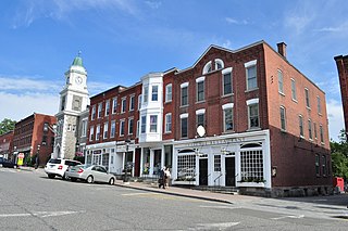
New London is a seaport city and a port of entry on the northeast coast of the United States, located at the outlet of the Thames River in New London County, Connecticut. The city is part of the Southeastern Connecticut Planning Region.

<span class="mw-page-title-main">Trumbull County, Ohio</span> County in Ohio, United States

Trumbull County is a county in the far northeast portion of the U.S. state of Ohio. As of the 2020 census, the population was 201,977. Its county seat and largest city is Warren, which developed industry along the Mahoning River. Trumbull County is part of the Youngstown–Warren, OH Metropolitan Statistical Area.

<span class="mw-page-title-main">Hartland, Connecticut</span> Town in Connecticut, United States

Hartland is a town in Hartford County, Connecticut, United States. The population was 1,901 at the 2020 census. The rural town is part of the Northwest Hills Planning Region and forms the northwest border of Hartford County. Currently, the town consists of two unincorporated areas, East and West Hartland, entirely separated by the northern portion of the Barkhamsted Reservoir. A third area, Hartland Hollow, was flooded when the reservoir was completed in 1940.

<span class="mw-page-title-main">Marlborough, Connecticut</span> Town in Connecticut, United States

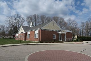
Marlborough is a town in Hartford County, Connecticut, United States. It contains the census-designated place (CDP) of Terramuggus. The town is part of the Capitol Planning Region. The town's population was 6,133 at the 2020 census. Marlborough is a suburban and rural community. The local high school is RHAM High School. In 2013, Marlborough ranked third in Connecticut Magazine's biannual ranking of Connecticut small towns. Educationally, RHAM High School, which serves Marlborough, Hebron, and Andover students, is one of the top-ranked regional high schools in the state on the SAT in 2017, and 11th highest-performing school in the state on the test. The town is home to Elmer Theines-Mary Hall elementary school which serves Pre-K through 6th grade. The school scores above state average on standardized testing and student progress.

<span class="mw-page-title-main">Salisbury, Connecticut</span> Town in Connecticut, United States

Salisbury is a town situated in Litchfield County, Connecticut, United States. The town is the northwesternmost in the state of Connecticut; the Massachusetts-New York-Connecticut tri-state marker is located at the northwest corner of the town. The population was 4,194 at the 2020 census. The town is part of the Northwest Hills Planning Region.

<span class="mw-page-title-main">Watertown, Connecticut</span> Town in Connecticut, United States

Watertown is a town in Litchfield County, Connecticut, United States. The town is part of the Naugatuck Valley Planning Region. The population was 22,105 at the 2020 census. The ZIP Codes for Watertown are 06795 and 06779. It is a suburb of Waterbury. The urban center of the town is the Watertown census-designated place, with a population of 3,938 at the 2020 census.

<span class="mw-page-title-main">Lebanon, Connecticut</span> Town in Connecticut, United States

Lebanon is a town in New London County, Connecticut. The town is part of the Southeastern Connecticut Planning Region. The population was 7,142 at the 2020 census. The town lies just to the northwest of Norwich, directly south of Willimantic, 20 miles (32 km) north of New London, and 20 miles (32 km) east of Hartford. It is best known for its role in the American Revolution when it was a major base of American operations, and for its historic town green, which is one of the largest in the nation and the only one still used partially for agriculture.

<span class="mw-page-title-main">Hebron, Connecticut</span> Town in Connecticut, United States

Hebron is a town in Tolland County, Connecticut, United States. The town is part of the Capitol Planning Region. The population was 9,098 at the 2020 census. Hebron was incorporated May 26, 1708. In 2010, Hebron was rated #6 in Top Towns in Connecticut with population between 6,500 and 10,000, according to Connecticut Magazine.

<span class="mw-page-title-main">East Hartford, Connecticut</span> Town in Connecticut, United States

East Hartford is a town in the Capitol Planning Region, Connecticut, United States. The population was 51,045 at the 2020 census. The town is located on the east bank of the Connecticut River, directly across from Hartford, Connecticut. It is home to aerospace manufacturer Pratt & Whitney. It is also home to Pratt & Whitney Stadium at Rentschler Field, a stadium used mainly for soccer and football with a capacity of 40,000 people.

<span class="mw-page-title-main">Wethersfield, Connecticut</span> Town in Connecticut, United States

Wethersfield is a town located in Hartford County, Connecticut, United States. It is located immediately south of Hartford along the Connecticut River. The town is part of the Capitol Planning Region. The population was 27,298 at the time of the 2020 census.

<span class="mw-page-title-main">Sherburne, New York</span> Town in New York, United States

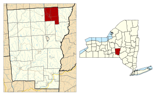
Sherburne is a town in Chenango County, New York, United States. The population was 4,048 at the 2010 census. The town contains two villages, Sherburne and Earlville. The town is at the northern border of Chenango County.

<span class="mw-page-title-main">Litchfield, Connecticut</span> Town in Connecticut, United States

Litchfield is a town in and former county seat of Litchfield County, Connecticut, United States. The population was 8,192 at the 2020 census. The town is part of the Northwest Hills Planning Region. The boroughs of Bantam and Litchfield are located within the town. There are also three unincorporated villages: East Litchfield, Milton, and Northfield. Northfield, located in the southeastern corner of Litchfield, is home to a high percentage of the Litchfield population.

<span class="mw-page-title-main">Bacon Academy</span> School in Colchester, Connecticut, United States

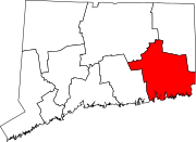
Bacon Academy is a public high school in Colchester, Connecticut, in the United States.

<span class="mw-page-title-main">Vienna Township, Trumbull County, Ohio</span> Township in Ohio, United States

Vienna Township is one of the twenty-four townships of Trumbull County, Ohio, United States. The 2020 census enumerated 3,978 people in the township.

<span class="mw-page-title-main">Jeremy Adams</span> Early settler of Hartford, Connecticut

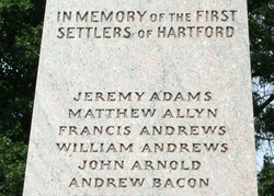
Jeremy Adams, also known as Jeremiah Adams, was one of the first settlers of Hartford, Connecticut. He was also the founder and first proprietor of Colchester, Connecticut, which was established on land owned by Adams, known as "Jeremiah's Farme".

Nathaniel Foote, was an early English immigrant and surveyor to Connecticut who was born in Colchester, England. He was part of the settlement party that founded Wethersfield, Connecticut, the oldest town in that state. Foote's wife, Elizabeth, was the sister of John Deming, considered one of the "fathers of Connecticut." In 1635, he surveyed the boundaries between his hometown of Wethersfield and Hartford.

References

  1. "Census - Geography Profile: Colchester town, New London County, Connecticut". United States Census Bureau . Retrieved November 27, 2021.
  2. "Census - Geography Profile: Colchester CDP, Connecticut". United States Census Bureau . Retrieved November 27, 2021.
  3. "Aurelius Piper, chief of Connecticut tribe". Boston Globe. Associated Press. August 6, 2008. Retrieved August 7, 2010.
  4. Adams, Arthur; Clement, John B; Satterhwaite, Elizabeth B; Adams, James L (1896). Arthur Adams collection. OCLC   66465301.
  5. 1 2 3 4 "Old Historical City, County and State Maps of Connecticut". Mapgeeks. December 9, 2017. Retrieved May 5, 2022.
  6. "Right to Farm". cltsite. Retrieved May 5, 2022.
  7. 1 2 "Colchester, Connecticut Genealogy and History USGenWeb Project". www.ctgenweb.org. Retrieved May 5, 2022.
  8. 1 2 3 4 5 "An Historical Address; Delivered at the Celebration of the Two Hundredth Anniversary, of the First Church of Christ, in Colchester, Connecticut". www.forgottenbooks.com. Retrieved May 5, 2022.
  9. 1 2 Marshall, Benjamin Tinkham (1922). A Modern History of New London County, Connecticut. Lewis Historical Publishing Company.
  10. Gannett, Henry (1905). The Origin of Certain Place Names in the United States. Govt. Print. Off. pp.  87.
  11. 1 2 3 4 5 6 Walter, Gary. Historical Landmarks, A Historical Tour Of Colchester. Colchester Connecticut: Colchester History Society.
  12. 1 2 3 4 5 6 7 "Extracts from the records of Colchester, with some transcripts from the recording of Michaell Taintor ..." Library of Congress. Retrieved April 7, 2022.
  13. "Ancient Burial Grounds | Colchester CT". www.colchesterct.gov. Retrieved May 5, 2022.
  14. 1 2 "History of the Town of Colchester CT | Colchester Society". www.colchesterhistory.org. Retrieved April 7, 2022.
  15. 1 2 3 4 5 6 7 8 9 10 "Hartford, Connecticut Breaking News, Sports & Entertainment - Hartford Courant". courant.com. Retrieved May 10, 2022.
  16. "1800s Colchester Bank Scandal | Colchester Historical Society". www.colchesterhistory.org. Retrieved May 10, 2022.
  17. Bacon, George F (1890). The leading business men of Willimantic and Colchester ... Boston: Mercantile Publishing Company. OCLC   1048219371.
  18. Colchester Historical Society. "The Hurricane of 1938". Colchester Historical Society.
  19. Spaulding, Marion (August 2000). "Town of Colchester, CT" (PDF). eCode 360. p. 290.{{cite web}}: CS1 maint: date and year (link)
  20. "MONEY Magazine: Best places to live 2005 Top 100 (3)". money.cnn.com. Retrieved May 10, 2022.
  21. Climate Summary for Colchester, Connecticut
  22. "Census of Population and Housing". Census.gov. Retrieved June 4, 2015.
  23. "United States Census Bureau QuickFacts". United States Census Bureau QuickFacts. United States Census Bureau. United States Census Bureau. 2020.
  24. "U.S. Census website". United States Census Bureau . Retrieved January 31, 2008.
  25. "Registration and Party Enrollment Statistics as of October 29, 2019" (PDF). Connecticut Secretary of State. Retrieved March 22, 2020.
  26. "General Election Statements of Vote, 1922 – Current". CT Secretary of State. Retrieved December 21, 2020.
  27. "Election Night Reporting". CT Secretary of State. Retrieved December 21, 2020.
  28. 1 2 Who Was Who in America, Historical Volume, 1607–1896. Chicago: Marquis Who's Who. 1963.
  29. "Be(a)man". WSHU PBS. April 3, 2020. Retrieved January 15, 2023.