Woodbridge, Connecticut

Last updated
Woodbridge, Connecticut
Town of Woodbridge
ThomasDarlingHouseWoodbridgeCT.jpg
Darling House Museum, built in 1774
WoodbridgeCtTownSeal.png
Woodbridge CT lg.PNG
Woodbridge, Connecticut
Coordinates: 41°21′15″N73°00′41″W / 41.35417°N 73.01139°W / 41.35417; -73.01139
CountryFlag of the United States (23px).png  United States
U.S. state Flag of Connecticut.svg  Connecticut
County New Haven
Region South Central CT
Incorporated1784
Government
  Type Selectman-town meeting
  First SelectmanMica Cardozo (D)
  Board of Selectmen
  • Sheila McCreven (D)
  • Steve Munno. (D)
  • David Lober (R)
  • Andrea Urbano (R)
  • Maria Madonick (D)
Area
  Total19.2 sq mi (49.7 km2)
  Land18.8 sq mi (48.8 km2)
  Water0.4 sq mi (1.0 km2)
Elevation
348 ft (106 m)
Population
 (2020)
  Total9,087
  Density470/sq mi (180/km2)
Time zone UTC-5 (Eastern)
  Summer (DST) UTC-4 (Eastern)
ZIP code
06525
Area code(s) 203/475
FIPS code 09-87700
GNIS feature ID0213539
Website www.woodbridgect.org

Woodbridge is a town in New Haven County, Connecticut, United States. The town is part of the South Central Connecticut Planning Region. The population was 9,087 at the 2020 census. [1] The town center is listed on the National Register of Historic Places as Woodbridge Green Historic District. Woodbridge is part of the Amity Regional School District #5, rated the #1 school district in New Haven County and the 10th best school district in CT by Niche in 2021. [2] As of 2019 Woodbridge has the 7th highest median household income in CT. [3]

Contents

History

Woodbridge was originally called "Amity", having been carved out of land originally belonging to New Haven and Milford as an independent parish in 1739. In 1742, the Rev. Benjamin Woodbridge was ordained in Amity, and it is after him that the modern town was named. Woodbridge was incorporated in 1784. [4]

In 1661, the town was the location of one of the hideouts of the "Regicides"—three of the judges who signed the death warrant for King Charles I of England. The ruins of their hideout can be found on the nearby West Rock ridge, which runs along the town's eastern border.

Thomas Darling (1720–1789), a tutor at Yale College and later an entrepreneur in New Haven, moved to town in 1774. His home is now the Darling House Museum, operated by the Amity & Woodbridge Historical Society. [5] The original farms of Woodbridge were located in the area of the West River Valley known as The Flats.

In the modern era, Woodbridge has undergone significant suburbanization.

Following the onset 2020 George Floyd protests, Woodbridge and other affluent towns in Connecticut have faced criticism certain civic organizations alleging the practice of exclusionary zoning. In early 2021, local housing advocacy group Open Communities Alliance called upon Woodbridge to amend its zoning codes to allow for more housing developments, and enable more low-income and minority residents to live in the town. [6] The group cited that just 0.2% of Woodbridge’s land area permits two-family dwellings. [6] In response to efforts by the group, Woodbridge's Town Plan and Zoning Commission approved a revision in June 2021 to the town's zoning rules to allow for multi-family homes and ADUs on 2% the town's land. [7] [8] The Open Communities Alliance voiced disappointment regarding the scale of the change, [8] and filed a lawsuit alleging Woodbridge was in violation of Connecticut's Zoning Enabling Act and Fair Housing Act in August 2022 in a case which has attracted statewide attention. [9] [10]

Government and politics

Woodbridge is governed by a 6-member Board of Selectmen. [11]

Woodbridge's current First Selectwoman is Beth Heller, whose term expires in June 2023. [11] Heller has served as the town's First Selectwoman since May 2017, and has been re-elected in May 2019 and May 2021. [12] Heller previously served as interim First Selectwoman from April to June 2013, following the death of former First Selectman Ed Sheehy. [13]

The town's previous First Selectwoman was Democrat Ellen Scalettar, who was first elected in 2013, and was re-elected in 2015. Scalettar did not seek a third term in 2017. [14]

Prior to Scalettar, Democrat Ed Sheehy served as the town's First Selectman. He became First Selectman in April 2006. Sheehy served on the Board of Selectmen for 27 years as a regular selectman. The Board of Selectmen elected Sheehy First Selectman by a 3 to 2 vote, along party lines, to replace Amey Marella (Republican), who stepped down to accept a job as Deputy Commissioner of the Connecticut Department of Environmental Protection. Before becoming First Selectwoman in 2001, Marella was an attorney with the United States Environmental Protection Agency. Edward Sheehy was reelected in May 2009 to another two-year term. On April 22, 2013, Sheehy died suddenly at the age of 73 while still holding the First Selectman's office. He was actively seeking re-election in May. He was laid to rest on April 27, 2013. [15]

Recent First Selectman elections
YearDemocratic candidateRepublican candidate
2023Mica Cardozo (1,926 Votes)Marty Halprin (1,393 Votes)
2021 [16] Beth HellerNone
2019 [17] Beth Heller (1,571 votes)Ed Weinberg (1,017 votes)
2017 [18] Beth Heller (1,820 votes)Tony Anastasio (1,454 votes)
2015 [19] Ellen Scalettar (1,579 votes)Cathy Wick (1,523 votes)
2013[ citation needed ]Ellen ScalettarCathy Wick
Woodbridge town vote
by party in presidential elections [20]
Year Democratic Republican Third Parties
2020 [21] 67.17%3.856 [21] 31.65% 1,817 [21] 1.18% 68 [21]
2016 [22] 62.42%3,333 [22] 33.97% 1,814 [22] 3.61% 193 [22]
2012 [23] 58.39%3,018 [23] 40.80% 2,109 [23] 0.81% 42 [23]

Education

Elementary school

Beecher Road School is the town's pre Kindergarten-Grade 6 school. [24]

Middle school

As part of the Amity school system, Woodbridge shares a middle school with the town of Bethany, which is located north of Woodbridge.

High school

Woodbridge also shares the Amity Regional High School with the neighboring towns of Bethany and Orange. The high school is located in Woodbridge's town center area.

Woodbridge is home to Ezra Academy, a regional Jewish day school whose students reside in 21 towns throughout New Haven and Fairfield counties. [25]

Geography

According to the United States Census Bureau, the town has a total area of 19.2 square miles (50 km2), of which 18.8 square miles (49 km2) is land and 0.4 square miles (1.0 km2) is water. The total area is 2.03% water.

Woodbridge is informally divided into two distinct parts: central Woodbridge, which occupies the western hilly side of town; and the area known as The Flats, which occupies the eastern slice of town, bordering West Rock and the New Haven neighborhood of Westville.

Neighboring towns are Bethany to the north, Hamden to the east, New Haven, and West Haven to the southeast, Orange to the south, and Derby, Ansonia, and Seymour to the west.

Parks and hiking trails

Below Wepawaug Falls in Woodbridge Alice-newton-park-woodbridge-ct.jpg
Below Wepawaug Falls in Woodbridge

Woodbridge is home to several organizations that protect undeveloped land and historic sites, including the Woodbridge Land Trust and the Woodbridge Park Association. [26] The town has an extensive system of preserved hiking trails open to the public, notably the 93-acre (380,000 m2) Alice Newton Street Memorial Park and the 22-acre (89,000 m2) Wepawaug Falls area. Some of the land has been donated by residents. [27]

Demographics

Historical population
CensusPop.Note
1820 1,988
1850 912
1860 872−4.4%
1870 829−4.9%
1880 92611.7%
1890 9260.0%
1900 852−8.0%
1910 8783.1%
1920 1,17033.3%
1930 1,63039.3%
1940 2,26238.8%
1950 2,82224.8%
1960 5,18283.6%
1970 7,67348.1%
1980 7,7611.1%
1990 7,9242.1%
2000 8,98313.4%
2010 8,9900.1%
2020 9,0871.1%
U.S. Decennial Census [28]

As of the census [29] of 2020, there were 9,087 people, 2,897 households, and 2,353 families in the town. The population density was 477.0 inhabitants per square mile (184.2/km2). There were 3,476 housing units at an average density of 169.3 per square mile (65.4/km2). The racial makeup of the town was 74.5% White, 3.07% African American, 0.17% Native American, 13.3% Asian, 0.033% Pacific Islander, 1.91% from other races, and 6.99% from two or more races. 6.02% of the population were Hispanic or Latino of any race.

Out of 2,897 households, there were 2,353 families in which 70% were married couple family households, 13.9% female householder with no spouse present, and 10.5% male householder with no spouse present. 36% of households have one or more person under the age of 18. 61.1% of the population is actively married. 13.7% of all households were made up of individuals, and 9.1% had someone living alone who was 65 years of age or older. The average family size was 3.31. 5.8% of the population was under the age of 5, 23.2% of the population was under the age of 18, 76.8% of the population was 18 years and over, and 24.8% were 65 years of age or older. The median age was 49.3 years. For every 100 females, there were 100.7 males.

The median income for a household in the town was $157,610, and the median income for a family was $166,546. As of 2010, males had a median income of $105,632 versus $70,286 for females. The per capita income for the town was $69,179. [30] 3.5% of the population and 1.4% of families were below the poverty line. 3.3% of those under the age of 18 and 4% of those 65 and older were living below the poverty line.

Voter registration and party enrollment as of October 27, 2020 [31]
PartyActive votersInactive votersTotal voters
Republican 1,3051191,424
Democratic 2,6452432,888
Unaffiliated 2,6274313,058
Minor Parties959104
Total6,6728027,474

Other

Notable people

Notable locations

On the National Register of Historic Places

Related Research Articles

<span class="mw-page-title-main">Hartford County, Connecticut</span> County in Connecticut, United States

Hartford County is a county located in the north central part of the U.S. state of Connecticut. According to the 2020 census, the population was 899,498, making it the second-most populous county in Connecticut. Hartford County contains the city of Hartford, the state capital of Connecticut and the county's most populous city, with 121,054 residents at the 2020 census. Hartford County is included in the Hartford-East Hartford-Middletown metropolitan statistical area.

<span class="mw-page-title-main">Litchfield County, Connecticut</span> County in Connecticut, United States

Litchfield County is in northwestern Connecticut, United States. As of the 2020 census, the population was 185,186. The county was named after Lichfield, in England. Litchfield County has the lowest population density of any county in Connecticut and is the state's largest county by area.

<span class="mw-page-title-main">New Haven County, Connecticut</span> County in Connecticut, United States

New Haven County is a county in the south central part of the U.S. state of Connecticut. As of the 2020 census, the population was 864,835, making it the third-most populous county in Connecticut. Two of the state's top 5 largest cities, New Haven (3rd) and Waterbury (5th), are part of New Haven County.

<span class="mw-page-title-main">Easton, Connecticut</span> Town in Connecticut, United States

Easton is a town in Fairfield County, Connecticut, United States. As of the 2020 census, the population was 7,605. Easton contains the historic district of Aspetuck and the Plattsville census-designated place. It is a part of the Greater Bridgeport Planning Region, the New York metropolitan statistical area, and is bordered by the towns of Fairfield to the south, Redding to the north, Weston to the west, and Monroe and Trumbull to the east.

<span class="mw-page-title-main">Greenwich, Connecticut</span> Town in Connecticut, United States

Greenwich is a town in southwestern Fairfield County, Connecticut, United States. At the 2020 census, it had a population of 63,518. Greenwich is a principal community of the Bridgeport–Stamford–Norwalk–Danbury metropolitan statistical area, which comprises all of Fairfield County, and is part of the Western Connecticut Planning Region. The town is the southwesternmost municipality in both the State of Connecticut and the six-state region of New England. The town is named after Greenwich, a royal borough of London in the United Kingdom.

<span class="mw-page-title-main">Monroe, Connecticut</span> Town in Connecticut, United States

Monroe is a town located in eastern Fairfield County, Connecticut, United States. The population was 18,825 at the 2020 census. The town is part of the Greater Bridgeport Planning Region.

<span class="mw-page-title-main">Hartland, Connecticut</span> Town in Connecticut, United States

Hartland is a town in Hartford County, Connecticut, United States. The population was 1,901 at the 2020 census. The rural town is part of the Northwest Hills Planning Region and forms the northwest border of Hartford County. Currently, the town consists of two unincorporated areas, East and West Hartland, entirely separated by the northern portion of the Barkhamsted Reservoir. A third area, Hartland Hollow, was flooded when the reservoir was completed in 1940.

<span class="mw-page-title-main">Thomaston, Connecticut</span> Town in Connecticut, United States

Thomaston is a town in Litchfield County, Connecticut, United States. The town is part of the Naugatuck Valley Planning Region. The population was 7,442 at the 2020 census. The urban center of the town is the Thomaston census-designated place, with a population of 1,928 at the 2020 census.

<span class="mw-page-title-main">Bethany, Connecticut</span> Town in Connecticut, United States

Bethany is a town in New Haven County, Connecticut, United States. The town is part of the South Central Connecticut Planning Region. The population was 5,297 at the 2020 census.

<span class="mw-page-title-main">Oxford, Connecticut</span> Town in Connecticut, United States

Oxford is a residential town located in western New Haven County, Connecticut, United States. The town is part of the Naugatuck Valley Planning Region. The population was 12,706 at the 2020 Census. Oxford is the 26th-wealthiest town in the state by median household income. Distinct settled areas in the town include Oxford Center, Quaker Farms, and Riverside. Oxford belongs to the Bridgeport–Stamford–Norwalk Metropolitan Statistical Area, a subregion of the New York metropolitan area.

<span class="mw-page-title-main">Seymour, Connecticut</span> Town in Connecticut, United States

Seymour is a town located in New Haven County, Connecticut, United States. The town is part of the Naugatuck Valley Planning Region. The population was 16,748 at the 2020 census. Seymour is bordered by the towns of Oxford and Beacon Falls to the north, Bethany and Woodbridge to the east, Ansonia and Derby to the south, and Shelton to the west.

<span class="mw-page-title-main">Willington, Connecticut</span> Town in Connecticut, United States

Willington is a town in Tolland County, Connecticut, United States. The town is part of the Capitol Planning Region. The population was 5,566 at the 2020 census.

<span class="mw-page-title-main">Canterbury, Connecticut</span> Town in Connecticut, United States

Canterbury is a town in Windham County, Connecticut, United States. The town is part of the Northeastern Connecticut Planning Region. The population was 5,045 at the 2020 census.

<span class="mw-page-title-main">Scotland, Connecticut</span> Town in Connecticut, United States

Scotland is a town in Windham County, Connecticut. The town is part of the Northeastern Connecticut Planning Region. As of the 2020 census, the town population was 1,576. Scotland is a predominantly rural town with agriculture as the principal industry. Scotland is the least populated town in Windham County.

<span class="mw-page-title-main">Windsor Locks, Connecticut</span> Town in Connecticut, United States

Windsor Locks is a town in Hartford County, Connecticut, United States. The town is part of the Capitol Planning Region. As of the 2020 census, its population was 12,613. It is the site of Bradley International Airport, which serves the Greater Hartford-Springfield region and occupies approximately a third of the town. Windsor Locks is also the site of the New England Air Museum.

<span class="mw-page-title-main">Orange, Connecticut</span> Town in Connecticut, United States

Orange is a town in New Haven County, Connecticut, United States. The town is part of the South Central Connecticut Planning Region. The population was 14,280 at the 2020 census. The town is governed by a Board of Selectmen.

<span class="mw-page-title-main">Ridgefield, Connecticut</span> Town in Connecticut, United States

Ridgefield is a town in Fairfield County, Connecticut, United States. Situated in the foothills of the Berkshire Mountains and on the New York state border, Ridgefield has a population of 25,033 as of the 2020 census. The town is part of the Western Connecticut Planning Region. The town center, which was formerly a borough, is defined by the U.S. Census Bureau as a census-designated place. The town was settled then quickly incorporated by 1709.

<span class="mw-page-title-main">Durham, Connecticut</span> Town in Connecticut, United States

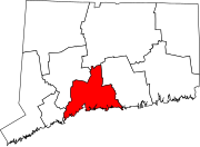
Durham is a town in Middlesex County, Connecticut, United States. Durham is a former farming village on the Coginchaug River in central Connecticut. The town is part of the Lower Connecticut River Valley Planning Region. The population was 7,152 at the 2020 census. Every autumn, the town hosts the Durham Fair, the largest volunteer agricultural fair in New England.

<span class="mw-page-title-main">Select board</span> Executive body of New England

The select board or board of selectmen is commonly the executive arm of the government of New England towns in the United States. The board typically consists of three or five members, with or without staggered terms. Three is the most common number, historically.

<span class="mw-page-title-main">Clinton, Connecticut</span> Town in Connecticut, United States

Clinton is a town in Middlesex County, Connecticut, United States. The town is part of the Lower Connecticut River Valley Planning Region. The population of the town was 13,185 at the 2020 census. The town center along the shore line was listed as a census-designated place (CDP) by the U.S. Census Bureau in the 2020 census.

References

  1. "Census - Geography Profile: Woodbridge town, New Haven County, Connecticut". United States Census Bureau . Retrieved December 23, 2021.
  2. "Amity Regional School District No. 5". Niche.
  3. "Census data: What's the median household income in your Connecticut town?". Hartford Courant. 2 January 2019.
  4. The Connecticut Magazine: An Illustrated Monthly. Connecticut Magazine Company. 1903. p. 335.
  5. "History" web page, Amity & Woodbridge Historical Association website, retrieved February 6, 2008,
  6. 1 2 Prevost, Lisa (2021-02-26). "A Push for Zoning Reform in Connecticut". The New York Times. ISSN   0362-4331. Archived from the original on 2022-09-22. Retrieved 2022-10-25.
  7. Thiel, Bettina (2021-06-24). "Zoning Opens Door to Affordability Concept". Woodbridge Town News. Archived from the original on 2022-04-07. Retrieved 2022-10-25.
  8. 1 2 Thomas, Jacqueline Rabe (2021-06-08). "Woodbridge zoning officials take a small step toward affordable housing". CT Mirror . Retrieved 2022-10-25.
  9. Monk, Ginny (2022-08-30). "Lawsuit claims Woodbridge zoning policy violates civil rights law". CT Mirror . Retrieved 2022-10-25.
  10. "Civil Rights Group Sues Woodbridge Over Zoning Practices". NBC Connecticut . 2022-08-30. Retrieved 2022-10-25.
  11. 1 2 "Board of Selectmen | Woodbridge, CT". www.woodbridgect.org. Retrieved 2022-10-25.
  12. "First Selectman's Office | Woodbridge, CT". www.woodbridgect.org. Retrieved 2022-10-25.
  13. "Woodbridge Democrats Unanimously Nominate First Selectman Beth Heller For Re-Election". Woodbridge Town News. 2019-02-07. Retrieved 2022-10-25.
  14. "Woodbridge First Selectwoman Ellen Scalettar stepping away to be with family on both coasts". New Haven Register. 2017-03-06. Retrieved 2022-10-25.
  15. "Obituary: Woodbridge First Selectman Edward Maum Sheehy, 73". Bethwood, Connecticut Patch. April 24, 2013.
  16. "After Low-Key Campaign, Candidates Face Voters On Monday". Woodbridge Town News. 2021-04-22. Retrieved 2022-10-25.
  17. "Democrats Win Local Elections, Gain Seats On Boards". Woodbridge Town News. 2019-05-30. Retrieved 2022-10-25.
  18. "Municipal Election Results From May 1, 2017". Woodbridge Town News. 2017-05-03. Retrieved 2022-10-25.
  19. "Prescribed Form For Return Of Votes Cast At A Municipal Election (Woodbridge)" (PDF). Office of the Secretary of the State. 2015-05-04. Retrieved 2022-10-25.
  20. "General Elections Statement of Vote 1922". The Office of the Secretary of State. Retrieved 10 August 2022.
  21. 1 2 3 4 "PARTY DESIGNATIONS" (PDF). Retrieved 2023-09-25.
  22. 1 2 3 4 "Statement of Vote" (PDF). 2016-11-08. Retrieved 2023-09-25.
  23. 1 2 3 4 "STATEMENT OF VOTE" (PDF). 2012-11-06. Retrieved 2023-09-25.
  24. "Woodbridge School District".
  25. Spring 2005 Ezra Academy pamphlet
  26. "Town of Woodbridge, CT - Community Links". Archived from the original on January 29, 2009. Retrieved February 17, 2009.
  27. "WOODBRIDGE PARK ASSOCIATION INC" (PDF). Archived from the original (PDF) on May 11, 2008. Retrieved February 17, 2009.
  28. "Census of Population and Housing". Census.gov. Retrieved June 4, 2015.
  29. "Woodbridge town, New Haven County, Connecticut". United States Census Bureau . Retrieved February 1, 2022.
  30. "Profile of General Population and Housing Characteristics: 2010 Demographic Profile Data (DP-1): Woodbridge town, New Haven County, Connecticut". United States Census Bureau . Retrieved October 1, 2012.
  31. "Registration and Party Enrollment Statistics as of October 27, 2020" (PDF). Connecticut Secretary of State. Retrieved February 1, 2022.
  32. LEE, MARA (16 May 2011). "Woodbridge Leads State In Advanced Degrees". courant.com. Retrieved May 25, 2020.