Eastford, Connecticut

Last updated
Eastford, Connecticut
Town of Eastford
EastfordCT PhoenixvilleMeetingHouse.jpg
EastfordCTseal.gif
Windham County Connecticut incorporated and unincorporated areas Eastford highlighted.svg
Eastford, Connecticut
Coordinates: 41°53′37″N72°05′49″W / 41.89361°N 72.09694°W / 41.89361; -72.09694 Coordinates: 41°53′37″N72°05′49″W / 41.89361°N 72.09694°W / 41.89361; -72.09694
CountryFlag of the United States.svg  United States
U.S. state Flag of Connecticut.svg  Connecticut
County Windham
Region Northeastern CT
Incorporated1847
Government
  Type Selectman-town meeting
  First selectmanJacqueline Dubois (R)
   State Senator Dan Champaigne
(R-35th District)
   State Rep. Pat Boyd
(D-50th District)
Area
  Total29.2 sq mi (75.6 km2)
  Land28.9 sq mi (74.8 km2)
  Water0.3 sq mi (0.9 km2)
Elevation
653 ft (199 m)
Population
 (2020)
  Total1,649
  Density56/sq mi (22/km2)
Time zone UTC-5 (Eastern)
  Summer (DST) UTC-4 (Eastern)
ZIP code
06242
Area code(s) 860/959
FIPS code 09-21860
GNIS feature ID213420
Major highways US 44.svg
Website www.eastfordct.org/townofeastford

Eastford is a town in Windham County, Connecticut, United States. The town is part of the Northeastern Connecticut Planning Region. The population was 1,649 at the 2020 census. [1]

Contents

History

Eastford was formed in 1847 when it was broken off from Ashford, Connecticut. The name "Eastford" is locational, for the town is east of Ashford. [2]

Geography

According to the United States Census Bureau, the town has a total area of 29.2 square miles (76 km2), of which, 28.9 square miles (75 km2) of it is land and 0.3 square miles (0.78 km2) of it (1.20%) is water.

Principal communities

On the National Register of Historic Places

Demographics

Historical population
CensusPop.Note
1850 1,127
1860 1,005−10.8%
1870 984−2.1%
1880 855−13.1%
1890 561−34.4%
1900 523−6.8%
1910 513−1.9%
1920 496−3.3%
1930 5296.7%
1940 496−6.2%
1950 59820.6%
1960 74624.7%
1970 92223.6%
1980 1,02811.5%
1990 1,31427.8%
2000 1,61823.1%
2010 1,7498.1%
2020 1,649−5.7%
U.S. Decennial Census [4]

At the 2000 census there were 1,618 people, 618 households, and 451 families living in the town. The population density was 56.0 inhabitants per square mile (21.6/km2). There were 705 housing units at an average density of 24.4 per square mile (9.4/km2). The racial makeup of the town was 97.78% White, 0.43% African American, 0.19% Native American, 0.37% Asian, 0.31% from other races, and 0.93% from two or more races. Hispanic or Latino of any race were 1.36%. [5]

There were 618 households, out of which 100 have children under the age of 18 living with them, 63.1% were married couples living together, 6.1% had a female householder with no husband present, and 27.0% were non-families. 21.8% of households were one person, and 9.1% were one person aged 65 or older. The average household size was 2.62 and the average family size was 3.06.

The age distribution was 26.3% under the age of 18, 5.6% from 18 to 24, 29.2% from 25 to 44, 25.4% from 45 to 64, and 13.4% 65 or older. The median age was 39 years. For every 100 females, there were 103.0 males. For every 100 females age 18 and over, there were 101.0 males.

The median household income was $57,159 and the median family income was $62,031. Males had a median income of $45,000 versus $31,964 for females. The per capita income for the town was $25,364. About 4.4% of families and 6.0% of the population were below the poverty line, including 10.0% of those under age 18 and 3.7% of those age 65 or over.

Eastford is a strongly Republican town. The town has voted for the Republican candidate every time since the 1856 election and since its founding in 1847 has never voted for a Democrat for president, the only town in Connecticut with this distinction. Even during President Lyndon B. Johnson's landslide in 1964, Eastford voters still preferred Barry Goldwater, the Republican candidate, by a comfortable 11.2% margin. Since 1992, however, the Democratic candidate has been more competitive. President Barack Obama only lost to Mitt Romney by 1 vote in 2012. [6]

Voter Registration and Party Enrollment as of October 27, 2009 [7]
PartyActive VotersInactive VotersTotal VotersPercentage
Republican 3912541634.84%
Democratic 290929925.04%
Unaffiliated 4373847539.78%
Minor Parties 0000.0%
Total1,121731,194100%
Presidential Election Results [6] [8]
Year Democratic Republican Third Parties
2020 43.5% 46453.6%5722.9% 31
2016 38.6% 36754.0%5137.4% 69
2012 49.0% 46449.1%4651.9% 18
2008 48.9% 48549.2%4881.9% 18
2004 44.0% 41654.3%5131.7% 16
2000 44.3% 37549.7%4216.0% 50
1996 38.1% 30141.7%32920.2% 159
1992 32.7% 28539.5%34427.8% 242
1988 34.9% 25363.8%4631.3% 9
1984 26.2% 17273.1%4790.7% 4
1980 29.1% 18355.7%35015.2% 95
1976 36.0% 20463.4%3590.6% 3
1972 29.6% 15269.9%3590.5% 2
1968 24.4% 10372.4%3053.2% 13
1964 44.4% 18855.6%2360.00% 0
1960 21.0% 8279.0%3090.00% 0
1956 15.6% 6284.4%3350.00% 0

Education

Residents are zoned to the Eastford School District for grades Preschool through 8. The only school in the district is Eastford Elementary School. Most high schoolers attend Woodstock Academy. The town is near five alternative high schools: Ellis Vocational Technical School, Windham Technical School, Killingly Vocational Agricultural High School, ACT High School, and Quinebaug Middle College.

Notable people

Trivia

There was another Eastford in the state which was renamed East Windsor shortly after its separation from Windsor.

Eastford is the site of Frog Rock, a rest stop and roadside attraction on U.S. Route 44. [9]

Related Research Articles

<span class="mw-page-title-main">Hartford County, Connecticut</span> County in Connecticut, United States

Hartford County is a county located in the north central part of the U.S. state of Connecticut. According to the 2020 census, the population was 899,498, making it the second-most populous county in Connecticut. Hartford County contains the city of Hartford, the state capital of Connecticut and the county's most populous city, with 121,054 residents at the 2020 census. Hartford County is included in the Hartford-East Hartford-Middletown metropolitan statistical area.

<span class="mw-page-title-main">Windham County, Connecticut</span> County in Connecticut, United States

Windham County is a county located in the northeastern corner of the U.S. state of Connecticut. As of the 2020 census, the population was 116,418, making it the least populous county in Connecticut. It forms the core of the region known as the Quiet Corner. Windham County is included in the Worcester, MA-CT Metropolitan Statistical Area, which is also included in the Boston-Worcester-Providence, MA-RI-NH-CT Combined Statistical Area. The entire county is within the Quinebaug and Shetucket Rivers Valley National Heritage Corridor, as designated by the National Park Service.

<span class="mw-page-title-main">Ashford, Alabama</span> Town in Alabama, United States

Ashford is a town in Houston County, Alabama, United States. It is part of the Dothan, Alabama Metropolitan Statistical Area. The town was incorporated in June 1891. For most of its history, it was a center for naval stores production, pulpwood harvesting, and cotton agriculture. The population was 2,148 at the 2010 census, up from 1,853 at the 2000 census.

<span class="mw-page-title-main">South Windsor, Connecticut</span> Town in Connecticut, United States

South Windsor is a town in Hartford County, Connecticut, United States. The population was 26,918 at the 2020 census.

<span class="mw-page-title-main">Voluntown, Connecticut</span> Town in Connecticut, United States

Voluntown is a town in New London County, Connecticut, United States. The town is part of the Northeastern Connecticut Planning Region. The population was 2,570 at the 2020 census. Voluntown was part of Windham County from 1726 to 1881.

<span class="mw-page-title-main">Andover, Connecticut</span> Town in Connecticut, United States

Andover is a rural town in the Capitol Planning Region, Connecticut, United States, roughly 10 miles West of Hartford. The population was 3,151 at the 2020 census. Andover is home to Andover Elementary School for grades K–6 while grades 7–12 go to R.H.A.M. middle and high schools. Andover elementary scores above average on standardized testing and student development as well as having a notably low student to teacher ratio of 8:1.

<span class="mw-page-title-main">Columbia, Connecticut</span> Town in Connecticut, United States

Columbia is a town in the Capitol Planning Region, Connecticut, United States. The population was 5,272 at the 2020 census. Originally a part of Lebanon, known as the North Society or Lebanon's Crank, Columbia was incorporated in May 1804. The town was named for patriotic reasons after the national symbol "Columbia". Columbia offers pre-kindergarten through 8th grade education in town at Horace W. Porter School, while high school students have a choice of attending four nearby high schools; E.O Smith High School, Bolton High School (Connecticut), Coventry High School, and Windham Technical High School, part of the Connecticut Technical High School System).

<span class="mw-page-title-main">Hebron, Connecticut</span> Town in Connecticut, United States

Hebron is a town in Tolland County, Connecticut, United States. The population was 9,098 at the 2020 census. Hebron was incorporated May 26, 1708. In 2010, Hebron was rated #6 in Top Towns in Connecticut with population between 6,500 and 10,000, according to Connecticut Magazine.

<span class="mw-page-title-main">Willington, Connecticut</span> Town in Connecticut, United States

Willington is a town in Tolland County, Connecticut, United States. The population was 5,566 at the 2020 census.

<span class="mw-page-title-main">Ashford, Connecticut</span> Town in Connecticut, United States

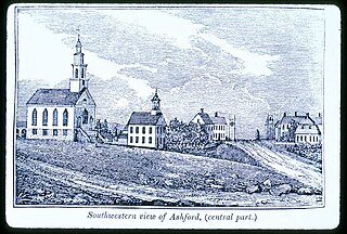
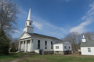
Ashford is a town in Windham County, Connecticut, United States. The town is part of the Northeastern Connecticut Planning Region. The population was 4,191 at the 2020 census. It was founded in 1714. Eastford was a part of Ashford until 1847, when the former split off to organize its own town. For this reason North Ashford is located in northeast Eastford.

<span class="mw-page-title-main">Brooklyn, Connecticut</span> Town in Connecticut, United States

Brooklyn is a town in Windham County, Connecticut, United States. The town is part of the Northeastern Connecticut Planning Region. The population was 8,450 at the 2020 census. The town center village is listed by the U.S. Census Bureau as a census-designated place. The district of East Brooklyn is listed as a separate census-designated place.

<span class="mw-page-title-main">Chaplin, Connecticut</span> Town in Connecticut, United States

Chaplin is a town in Windham County, Connecticut, United States. The town is part of the Northeastern Connecticut Planning Region. The town was named for Deacon Benjamin Chaplin, an early settler. The population was 2,151 at the 2020 census.

<span class="mw-page-title-main">Hampton, Connecticut</span> Town in Connecticut, United States

Hampton is a town in Windham County, Connecticut, United States. The town is part of the Northeastern Connecticut Planning Region. The population was 1,728 at the 2020 census.

<span class="mw-page-title-main">Plainfield, Connecticut</span> Town in Connecticut, United States

Plainfield is a town in Windham County, Connecticut, United States. The town is part of the Northeastern Connecticut Planning Region. The population was 14,973 at the 2020 census. The town comprises four villages: Plainfield, Moosup, Wauregan, and Central Village. Each village has their own respective United States Post Office and fire department. The entire town is serviced by the 860 area code.

<span class="mw-page-title-main">Pomfret, Connecticut</span> Town in Connecticut, United States

Pomfret is a town located in Windham County, Connecticut with a population of 4,266 according to the 2020 United States Census. The town is part of the Northeastern Connecticut Planning Region. The town was incorporated in 1713 and was named after Pontefract in West Yorkshire, England. The land on which Pomfret stands today was purchased from Native Americans in 1686 in a deal known as the "Mashmuket Purchase" or "Mashamoquet Purchase".

<span class="mw-page-title-main">Scotland, Connecticut</span> Town in Connecticut, United States

Scotland is a town in Windham County, Connecticut. The town is part of the Northeastern Connecticut Planning Region. As of the 2020 census, the town population was 1,576. Scotland is a predominantly rural town with agriculture as the principal industry. Scotland is the least populated town in Windham County.

<span class="mw-page-title-main">Sterling, Connecticut</span> Town in Connecticut, United States

Sterling is a town in Windham County, Connecticut, United States. The town is part of the Northeastern Connecticut Planning Region. The population was 3,578 at the 2020 census.

<span class="mw-page-title-main">Windham, Connecticut</span> Town in Connecticut, United States

Windham is a town in Windham County, Connecticut, United States. It contains the former city of Willimantic as well as the boroughs of Windham Center, North Windham, and South Windham. Willimantic, an incorporated city since 1893, was consolidated with the town in 1983. The population was 24,428 at the 2020 census.

<span class="mw-page-title-main">Woodstock, Connecticut</span> Town in Connecticut, United States

Woodstock is a town in Windham County, Connecticut, United States. The town is part of the Northeastern Connecticut Planning Region. The population was 8,221 at the 2020 census.

<span class="mw-page-title-main">Natchaug Trail</span> Hiking trail

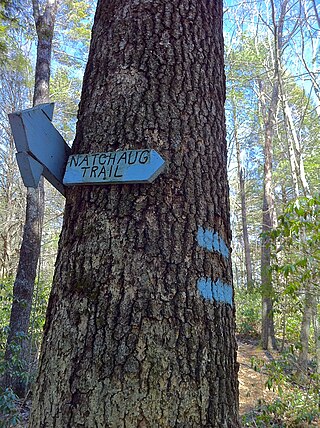
The Natchaug Trail is a Blue-Blazed hiking trail "system" which meanders through 19.5 miles (31.4 km) of forests in northeast Connecticut—primarily in Windham County. It is maintained by the Connecticut Forest and Park Association. Its southern trailhead begins in the James L. Goodwin State Forest in the towns of Chaplin, Connecticut and Hampton, Connecticut and the northern terminus is at its intersection with the Nipmuck Trail in Natchaug State Forest in Eastford, Connecticut.

References

  1. "Census - Geography Profile: Eastford town, Windsor County, Connecticut" . Retrieved December 15, 2021.
  2. The Connecticut Magazine: An Illustrated Monthly. Connecticut Magazine Company. 1903. p. 332.
  3. Federal Writer's Project for the State of Connecticut (1938). Connecticut; a Guide to Its Roads, Lore, and People. p. 434. ISBN   9781623760076 . Retrieved May 29, 2013.
  4. "Census of Population and Housing". Census.gov. Retrieved June 4, 2015.
  5. "U.S. Census website". United States Census Bureau . Retrieved 2008-01-31.
  6. 1 2 "General Election Statements of Vote, 1922 – Current". CT Secretary of State. Archived from the original on 2019-05-14. Retrieved May 2, 2021.
  7. "Registration and Party Enrollment Statistics as of October 27, 2009" (PDF). Connecticut Secretary of State. Archived from the original (PDF) on June 17, 2010. Retrieved 2010-08-14.
  8. "Election Night Reporting". CT Secretary of State. Archived from the original on 2016-04-28. Retrieved May 2, 2021.
  9. Haar, Dan (2014-08-18). "The Best Of Americana At Frog Rock Rest Stop". The Hartford Courant. Retrieved 2020-08-09.