Thomaston, Connecticut

Last updated

Thomaston, Connecticut
Town of Thomaston
THOMASTON,LITCHFIELD,CONNECTICUT.jpg
Autumn 2003 view of Thomaston from Plymouth
ThomastonCTseal.jpg
Motto: 
"A Town For All Time..." [1]
Litchfield County Connecticut Incorporated and Unincorporated areas Thomaston Highlighted 2010.svg
Thomaston, Connecticut
Coordinates: 41°40′15″N73°04′57″W / 41.67083°N 73.08250°W / 41.67083; -73.08250
CountryFlag of the United States.svg  United States
U.S. state Flag of Connecticut.svg  Connecticut
County Litchfield
Region Naugatuck Valley
Incorporated1875
Government
  Type Selectman-town meeting
  First selectmanEdmond V. Mone (R) [2] [3]
  SelectmanLawrence Duffany (R)
  SelectmanRoger Perreault (R)
Area
  Total12.2 sq mi (31.6 km2)
  Land12.0 sq mi (31.0 km2)
  Water0.2 sq mi (0.6 km2)
Elevation
446 ft (136 m)
Population
 (2020)
  Total7,442
  Density622/sq mi (240.1/km2)
Time zone UTC-5 (Eastern)
  Summer (DST) UTC-4 (Eastern)
ZIP codes
06787
Area code(s) 860/959
FIPS code 09-75730
GNIS feature ID0213515
Website www.thomastonct.org

Thomaston is a town in Litchfield County, Connecticut, United States. The town is part of the Naugatuck Valley Planning Region. The population was 7,442 at the 2020 census. [4] The urban center of the town is the Thomaston census-designated place, with a population of 1,928 at the 2020 census. [5]

Contents

History

The town, originally part of the town of Plymouth and referred to as "Plymouth Hollow", was first settled by Henry Cook ("the soldier in the wilderness", 1683–1750) around 1728. [6] :480 [7] The town is known for clockmaking, which started in 1803, when Eli Terry established a factory in the town. Terry brought mass production to the clockmaking industry, helping to reduce the cost of clocks. He introduced and patented the shelf clock in 1814, which reduced the cost of a clock from $25 to $5. His clocks were sold throughout the United States. [6] :480

The town was incorporated in its own right and under the name "Thomaston" in 1875. [8] The name derives from Seth Thomas, the early clockmaker, who established a factory in town in 1812. [6] :60 [8] The Seth Thomas clock factory building still exists; however, the clockmaking industry has long since left the state as well as the country.

Geography

Thomaston is in southeastern Litchfield County, bordered on the south by the city of Waterbury in New Haven County. According to the United States Census Bureau, the town has a total area of 12.2 square miles (31.6 km2). 12.0 square miles (31.0 km2) of it are land and 0.2 square miles (0.6 km2) of it (1.94%) are water. [9]

The town is located at the confluence of the Naugatuck River, Northfield Brook and Black Rock Brook, and is protected by US Army Corps of Engineers flood control dams on each of these watercourses. These were all constructed in the years immediately following the devastating flood of 1955 which ravaged the town as well as the state in general.

Principal communities

Adjacent towns and city

Demographics

Historical population
CensusPop.Note
1880 3,225
1890 3,2781.6%
1900 3,3000.7%
1910 3,5337.1%
1920 3,99313.0%
1930 4,1884.9%
1940 4,2381.2%
1950 4,89615.5%
1960 5,85019.5%
1970 6,2336.5%
1980 6,2760.7%
1990 6,94710.7%
2000 7,5038.0%
2010 7,8875.1%
2020 7,442−5.6%
U.S. Decennial Census [10]

As of the census [11] of 2000, there were 7,503 people, 2,916 households, and 2,067 families residing in the town. The population density was 624.7 inhabitants per square mile (241.2/km2). There were 3,014 housing units at an average density of 251.0 per square mile (96.9/km2). The racial makeup of the town was 97.85% White, Hispanic or Latino of any race were 1.45% of the population, 0.60% African American, 0.11% Native American, 0.49% Asian, 0.02% Pacific Islander, 0.41% from other races,and 0.53% from two or more races.

There were 2,916 households, out of which 34.3% had children under the age of 18 living with them, 57.5% were married couples living together, 9.2% had a female householder with no husband present, and 29.1% were non-families. 24.0% of all households were made up of individuals, and 9.7% had someone living alone who was 65 years of age or older. The average household size was 2.57 and the average family size was 3.07.

In the town, the population was spread out, with 25.3% under the age of 18, 6.2% from 18 to 24, 33.2% from 25 to 44, 23.2% from 45 to 64, and 12.1% who were 65 years of age or older. The median age was 38 years. For every 100 females, there were 97.2 males. For every 100 females age 18 and over, there were 94.8 males.

The median income for a household in the town was $54,297, and the median income for a family was $63,682. Males had a median income of $40,795 versus $31,744 for females. The per capita income for the town was $24,799. 4.2% of the population and 3.3% of families were below the poverty line. Of the total population, 5.8% of those under the age of 18 and 4.5% of those 65 and older were living below the poverty line.

Transportation

Thomaston station on the Naugatuck Railroad North end of Thomaston station, October 2020.jpg
Thomaston station on the Naugatuck Railroad

The Route 8 expressway runs along the Naugatuck River in the eastern part of town and has three exits in Thomaston. Other state highways in the town are U.S. Route 6, Connecticut Route 109, Route 222, and Route 254. Thomaston is headquarters of the Naugatuck Railroad, a heritage railway and short line freight operator that operates 21 miles (34 km) of former New Haven trackage between Waterbury and Torrington. Interchange is with Pan Am Railways at Highland Junction.

Schools

The town is home to Thomaston High School, a school with roughly up to 375 students, from grade 7 to 12. It is also home to Black Rock Elementary School, hosting Pre-K to 3rd grade, and Thomaston Center School, hosting the town's 4th, 5th, and 6th grade students.

Landmarks

Notable people

Related Research Articles

<span class="mw-page-title-main">Litchfield County, Connecticut</span> County in Connecticut, United States

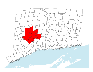
Litchfield County is in northwestern Connecticut, United States. As of the 2020 census, the population was 185,186. The county was named after Lichfield, in England. Litchfield County has the lowest population density of any county in Connecticut and is the state's largest county by area.

<span class="mw-page-title-main">New Haven County, Connecticut</span> County in Connecticut, United States

New Haven County is a county in the south central part of the U.S. state of Connecticut. As of the 2020 census, the population was 864,835, making it the third-most populous county in Connecticut. Two of the state's top 5 largest cities, New Haven (3rd) and Waterbury (5th), are part of New Haven County.

<span class="mw-page-title-main">Bantam, Connecticut</span> Borough in Connecticut, United States

Bantam is a borough in Litchfield County, Connecticut, United States. The population was 720 at the 2020 census. It is part of the town of Litchfield, and is the 2nd least populous borough in Connecticut, only beaten by Fenwick.

<span class="mw-page-title-main">Bethlehem, Connecticut</span> Town in Connecticut, United States

Bethlehem is a town in Litchfield County, Connecticut, United States. The population was 3,385 at the 2020 census, down from 3,607 at the 2010 census. The town is part of the Naugatuck Valley Planning Region. The town center is a historic district and a census-designated place (CDP).

<span class="mw-page-title-main">Bridgewater, Connecticut</span> Town in Connecticut, United States

Bridgewater is a town in Litchfield County, Connecticut, United States. The population was 1,662 at the 2020 census, down from 1,727 at the 2010 census. The town is part of the Western Connecticut Planning Region.

<span class="mw-page-title-main">Harwinton, Connecticut</span> Town in Connecticut, United States

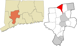
Harwinton is a town in Litchfield County, Connecticut, United States. The population was 5,484 at the 2020 census. The town is part of the Northwest Hills Planning Region. The high school is Lewis S. Mills.

<span class="mw-page-title-main">Northwest Harwinton, Connecticut</span> Census-designated place in Connecticut, United States

Northwest Harwinton is a census-designated place (CDP) in the town of Harwinton in Litchfield County, Connecticut, United States. The population was 3,158 at the 2020 census, out of 5,484 in the entire town. The CDP contains the town center.

<span class="mw-page-title-main">Oakville, Connecticut</span> Census-designated place in Connecticut, United States

Oakville is a census-designated place (CDP) and neighborhood section of Watertown, in Litchfield County, Connecticut, United States. The population was 9,047 as of the 2010 census. It is the most populous community in Watertown, with more than twice as many people as the center village of Watertown. The ZIP code for Oakville is 06779.

<span class="mw-page-title-main">Plymouth, Connecticut</span> Town in Connecticut, United States

Plymouth is a town in Litchfield County, Connecticut, United States. It is named after Plymouth, Devon, England. The population was 11,671 at the 2020 census, down from 12,243 at the 2010 census. The town of Plymouth includes the villages of Plymouth Center, Terryville and Pequabuck.

<span class="mw-page-title-main">Roxbury, Connecticut</span> Town in Connecticut, United States

Roxbury is a town in Litchfield County, Connecticut, United States. The population was 2,260 at the 2020 census. The town is located 65 miles (105 km) northeast of New York City, and is part of the Northwest Hills Planning Region.

<span class="mw-page-title-main">Terryville, Connecticut</span> Census-designated place in Plymouth, Connecticut, US

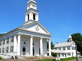
Terryville is a census-designated place (CDP) in Litchfield County, Connecticut, United States, and is the largest village within the town of Plymouth. In the 2010 census, Terryville had a population of 5,387, out of 12,243 in the entire town of Plymouth. The village is named for Eli Terry Jr., the son of the well-known clockmaker Eli Terry Sr. Terryville is also home to the Lock Museum of America. There is a water wheel located in downtown Terryville that is dedicated to the son of Eli Terry Sr.

<span class="mw-page-title-main">Warren, Connecticut</span> Town in Connecticut, United States

Warren is a town in Litchfield County, Connecticut, United States. The population was 1,351 at the 2020 census. The town is part of the Northwest Hills Planning Region. The town was named for Revolutionary War General Joseph Warren.

<span class="mw-page-title-main">Watertown, Connecticut</span> Town in Connecticut, United States

Watertown is a town in Litchfield County, Connecticut, United States. The town is part of the Naugatuck Valley Planning Region. The population was 22,105 at the 2020 census. The ZIP Codes for Watertown are 06795 and 06779. It is a suburb of Waterbury. The urban center of the town is the Watertown census-designated place, with a population of 3,938 at the 2020 census.

<span class="mw-page-title-main">Woodbury, Connecticut</span> Town in Connecticut, United States

Woodbury is a town in Litchfield County, Connecticut, United States. The town is part of the Naugatuck Valley Planning Region. The population was 9,723 at the 2020 census. The town center, comprising the adjacent villages of Woodbury and North Woodbury, is designated by the U.S. Census Bureau as the Woodbury Center census-designated place (CDP). Woodbury was founded in 1673.

<span class="mw-page-title-main">Middlebury, Connecticut</span> Town in Connecticut, United States

Middlebury is a town in New Haven County, Connecticut, United States. The population was 7,574 at the 2020 census. The town is part of the Naugatuck Valley Planning Region.

<span class="mw-page-title-main">Oxford, Connecticut</span> Town in Connecticut, United States

Oxford is a residential town located in western New Haven County, Connecticut, United States. The town is part of the Naugatuck Valley Planning Region. The population was 12,706 at the 2020 Census. Oxford is the 26th-wealthiest town in the state by median household income. Distinct settled areas in the town include Oxford Center, Quaker Farms, and Riverside. Oxford belongs to the Bridgeport–Stamford–Norwalk Metropolitan Statistical Area, a subregion of the New York metropolitan area.

<span class="mw-page-title-main">Naugatuck, Connecticut</span> Consolidated borough and town in Connecticut, US

Naugatuck is a consolidated borough and town in New Haven County, Connecticut, United States. The town spans both sides of the Naugatuck River just south of Waterbury and includes the communities of Union City on the east side of the river, which has its own post office, Straitsville on the southeast, and Millville on the west. The town is part of the Naugatuck Valley Planning Region. As of the 2020 census, Naugatuck had a population of 31,519.

<span class="mw-page-title-main">Central Naugatuck Valley</span> Place in Connecticut, United States

The Central Naugatuck Valley is a region of Connecticut in New Haven and Litchfield counties located approximately 70 miles (110 km) northeast of New York City and 110 miles (180 km) southwest of Boston, United States. The region comprises 13 towns: Beacon Falls, Bethlehem, Cheshire, Middlebury, Naugatuck, Oxford, Prospect, Southbury, Thomaston, Waterbury, Watertown, Wolcott, and Woodbury.

<span class="mw-page-title-main">Watertown (CDP), Connecticut</span> Census-designated place in Connecticut, United States

Watertown is a census-designated place (CDP) in Litchfield County, Connecticut, United States. It comprises the central village of the town of Watertown. As of the 2010 census, the population of the CDP was 3,574, out of 22,514 in the entire town. As of the 2020 Census, the population was 22,105.

<span class="mw-page-title-main">Thomaston (CDP), Connecticut</span> Census-designated place in Connecticut, United States

Thomaston is a census-designated place (CDP) in Litchfield County, Connecticut, United States. It comprises the downtown portion of the town of Thomaston. As of the 2010 census, the population of the CDP was 1,910, out of 7,887 in the entire town.

References

  1. "Town of Thomaston Connecticut". Town of Thomaston Connecticut. Retrieved September 22, 2012.
  2. "Board of Selectmen". Town of Thomaston, CT. Retrieved September 16, 2015.
  3. "Thomaston CT Municipal Election Results, 2013" (PDF). Connecticut Secretary of State. Retrieved September 16, 2015.
  4. "Census - Geography Profile: Thomaston town, Litchfield County, Connecticut". United States Census Bureau . Retrieved December 22, 2021.
  5. "Census - Geography Profile: Thomaston CDP, Connecticut". United States Census Bureau . Retrieved December 22, 2021.
  6. 1 2 3 Federal Writers' Project (1938). Connecticut: A Guide to Its Roads, Lore and People. US History Publishers. ISBN   978-1-60354-007-0 . Retrieved September 23, 2010.
  7. History of Litchfield County, Part 1. J.W. Lewis & Co. 1881. p. 488. Retrieved January 30, 2015.
  8. 1 2 "History". Town of Thomaston. Archived from the original on March 31, 2010. Retrieved May 7, 2010.
  9. "Geographic Identifiers: 2010 Census Summary File 1 (G001), Thomaston town, Litchfield County, Connecticut". American FactFinder. U.S. Census Bureau. Archived from the original on February 13, 2020. Retrieved October 15, 2019.
  10. "Census of Population and Housing". Census.gov. Retrieved June 4, 2015.
  11. "U.S. Census website". United States Census Bureau . Retrieved January 31, 2008.

Commons-logo.svg Media related to Thomaston, Connecticut at Wikimedia Commons