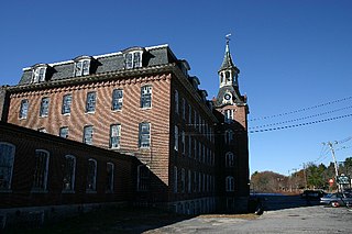
Wilder is an unincorporated village and census-designated place (CDP) within the town of Hartford in Windsor County, Vermont, United States. It is the location of the Wilder Dam on the Connecticut River. The population of the CDP was 1,690 at the 2010 census. The village center is an early example of a planned mill community, and was listed on the National Register of Historic Places as the Wilder Village Historic District in 1999.

The Farmington River is a river, 46.7 miles (75.2 km) in length along its main stem, located in northwest Connecticut with major tributaries extending into southwest Massachusetts. The longest route of the river, from the origin of its West Branch, is 80.4 miles (129.4 km) long, making it the Connecticut River's longest tributary by 2.3 miles (3.7 km) over the major river directly to its north, the Westfield River. The Farmington River's watershed covers 609 square miles (1,580 km2). Historically, the river played an important role in small-scale manufacturing in towns along its course, but it is now mainly used for recreation and drinking water.

The Ashburnham Center Historic District is a historic district encompassing the core of the village center of Ashburnham, Massachusetts in the United States. It is a well-preserved industrial village that experienced its most significant period of growth in the mid-19th century. The district was added to the National Register of Historic Places in 1999.

The neighborhoods of Hartford, Connecticut in the United States are varied and historic.
Linwood is a village with its own post office in the towns of Northbridge and Uxbridge, Massachusetts, United States.

The Dayville Historic District encompasses a collection of mid-19th century architecture in the Dayville village of Killingly, Connecticut. It is clustered around the junction of Main and Pleasant streets, extending along Main to High Street. The area flourished in the mid-19th century, as a consequence of the railroad being routed nearby, serving area textile mills. The district, residential except for a church, was added to the National Register of Historic Places in 1988.

The Tariffville Historic District is a 93 acres (38 ha) historic district in the town of Simsbury, Connecticut. It was listed on the National Register of Historic Places in 1993. It is part of the Tariffville section of Simsbury. The district includes 165 contributing buildings and two contributing sites. It also includes 26 non-contributing buildings and 4 non-contributing sites. There are several houses in the district of Gothic Revival style, probably following designs from pattern books of architect Andrew Jackson Downing. The Trinity Episcopal Church is the only building in the district designed by an architect of national standing, namely Henry C. Dudley. Many of the homes in the area were built by the Tariff Manufacturing Company, which opened a carpet mill along the Farmington River, and needed housing for workers.

The Hotchkissville Historic District is a historic district in the town of Woodbury, Connecticut, United States that was listed on the National Register of Historic Places in 1995. The district encompasses most of the historic village of Hotchkissville, which is centered at the junction of Washington and Weekeepeemee roads. The village began as a dispersed rural agricultural community, but developed in the 19th century with the arrival of industry, primarily the manufacture of textiles. Despite this, the village has retained a significantly rural character, and includes a broad cross-section of 18th- and 19th-century architectural styles.

The Bradstreet Historic District encompasses the rural 19th-century village of Bradstreet in Hatfield, Massachusetts. It is centered at the junction of Depot Road and Main Street, and includes properties lining those two streets and Old Farm Road. Most of the buildings in the area date to the second half of the 19th century, featuring architectural styles typical of the period, including Queen Anne, Second Empire, Italianate, and Colonial Revival. The village grew on land that was originally granted to colonial governor Simon Bradstreet and divided in 1682, and has remained largely agricultural since then. The district was listed on the National Register of Historic Places in 1997.
The North Stonington Village Historic District is a 105-acre (42 ha) historic district encompassing the historic center of the main village of North Stonington, Connecticut. The district includes a well-preserved small industrial village, which flourished in the years before the American Civil War, and declined afterward. The district was listed on the National Register of Historic Places in 1983.

The George–Pine–Henry Historic District encompasses a residential area of the village of Bellows Falls, Vermont. Located west of downtown Bellows Falls, the area has a significant concentration of well-preserved late 19th and early 20th-century residences. It was listed on the National Register of Historic Places in 2010.

The Quechee Historic Mill District encompasses the historic heart of the village of Quechee, Vermont, a well-preserved 19th-century mill village. Extending along Quechee Main Street between the Old Quechee Road and the Quechee-West Hartford Road, the village was settled in the 1760s, and has an industrial history extending into the 20th century. It was listed on the National Register of Historic Places in 1997.

The Tunbridge Village Historic District encompasses the early 19th-century village center of Tunbridge, Vermont. Stretched linearly along Vermont Route 110, the largely agricultural village reached its peak population around 1820, and was bypassed by the railroads, limiting later development. It was listed on the National Register of Historic Places in 1994.

The Plainfield Village Historic District encompasses a significant portion of the village of Plainfield, Vermont. Located in northernmost Plainfield on United States Route 2, the village grew in the 19th century as a mill town and service community for the surround agricultural areas, and has a well-preserved collection of Greek Revival and Italianate architecture. It was listed on the National Register of Historic Places in 1983.

The Warren Village Historic District encompasses the village center of Warren, Vermont, United States. Stretched mainly along Main Street east of the Mad River, it is a well-preserved 19th-century mill village, although most of its period mill infrastructure has been lost. The district has good examples of Greek Revival, Italianate, and Second Empire architecture. It was listed on the National Register of Historic Places in 1992.
The Philip Chapin House is a historic house at 55 Church Street in the Pine Meadow village of New Hartford, Connecticut. Built in 1867 for a local factory owner, it is an elaborate example of Italianate architecture. It was listed on the National Register of Historic Places in 1977.

The Central Avenue-Center Cemetery Historic District encompasses part of the town center of East Hartford, Connecticut. Although it was founded in the mid-17th century, it is now dominated by architecture of the late 19th and early 20th centuries. The Center Cemetery is the town's oldest surviving property, and includes the grave of William Pitkin, a colonial governor. The district, including portions of Main Street and Central Avenue, was listed on the National Register of Historic Places in 1993.

The Curtisville Historic District encompasses a predominantly residential area along Naubuc Avenue and Pratt Streets in northwestern Glastonbury, Connecticut. Developed mainly in the 19th century, it illustrates the coexistence of agricultural and industrial pursuits in a single village area, mixing worker housing, former farm properties, and a small mill complex. The district was listed on the National Register of Historic Places in 1992.
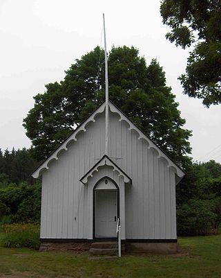
The Pine Grove Historic District encompasses a well-preserved collection of primarily 19th-century farmsteads, located near one another and a local district school building in Avon, Connecticut. Centered around the junction of West Avon and Harris Roads are four 19th-century farmsteads, one dating to the 18th century, and the 1865 Gothic Revival Pine Grove School. The district was listed on the National Register of Historic Places in 1980.

The Palisado Avenue Historic District encompasses a predominantly residential streetscape in northeastern Windsor, Connecticut. Extending along Palisado Avenue between the Farmington River and Bissell Ferry Road, it is a basically 18th-century street view, populated mainly with houses from the 18th to the 20th centuries. The district was listed on the National Register of Historic Places in 1987.