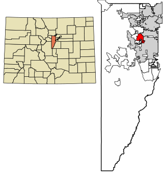
Applewood is an unincorporated community and a census-designated place (CDP) located in and governed by Jefferson County, Colorado, United States. The CDP is a part of the Denver–Aurora–Lakewood, CO Metropolitan Statistical Area. The population of the Applewood CDP was 7,833 at the 2020 United States Census. The Golden post office serves the area.

West Pleasant View is an unincorporated community and a census-designated place (CDP) located in and governed by Jefferson County, Colorado, United States. The CDP is a part of the Denver–Aurora–Lakewood, CO Metropolitan Statistical Area. The population of the West Pleasant View CDP was 4,327 at the United States Census 2020. The Pleasant View Metropolitan District provides services. The Golden post office serves the area.

Salt Point is a hamlet and census-designated place (CDP) located in the Town of Pleasant Valley, Dutchess County, New York, United States. As of the 2020 census it had a population of 202. It lies northeast of Poughkeepsie following New York Route 115, the Salt Point Turnpike. East of Salt Point, the Taconic State Parkway allows for access to many of the surrounding towns and communities, with easy travel to New York City. The area code is 845.
Saugatuck is a census-designated place (CDP) in the town of Westport, Fairfield County, Connecticut, United States. It is in the southwest part of the town, on both sides of the Saugatuck River, extending south to where it enters Long Island Sound. North of Interstate 95, it occupies just the west side of the Saugatuck and continues north as far as U.S. Route 1. It is bordered to the north by Westport Village and to the west by the city of Norwalk. The CDP includes the communities of Owenoke and Saugatuck Shores, as well as the Metro-North Railroad Westport station.

West Cornwall is an unincorporated village and census-designated place (CDP) in the town of Cornwall, Litchfield County, Connecticut, United States. It is on the west side of the town, on the east side of the Housatonic River, which forms the border with the town of Sharon. Connecticut Route 128 runs through the village, joining U.S. Route 7 across the Housatonic in Sharon.
Topstone is a census-designated place (CDP) in the town of Redding, Fairfield County, Connecticut, United States. It is on the west side of the town and is bordered to the west by the town of Ridgefield.

Dodgingtown is a census-designated place (CDP) in the town of Newtown, Fairfield County, Connecticut, United States. It on the west side of Newtown and is bordered to the west by the town of Bethel. Connecticut Route 302 passes through the center of the community.
Compo is a census-designated place (CDP) in the town of Westport, Fairfield County, Connecticut, United States. It is in the south-central part of the town, lying between the Saugatuck River and the neighborhood of Saugatuck to the west, and Compo Cove, Sherwood Millpond, and the neighborhood of Greens Farms to the east. The CDP extends south to Compo Beach on Long Island Sound and north to U.S. Route 1. Interstate 95 crosses the middle of the CDP from east to west, with access from either Saugatuck or Greens Farms.
Wilmington is the primary village and a census-designated place (CDP) in the town of Wilmington, Windham County, Vermont, United States. As of the 2020 census, it had a population of 439, compared to 2,255 in the entire town. The center of the village is part of the Wilmington Village Historic District.
Hopkinton is a census-designated place (CDP) in Washington County, Rhode Island, United States, comprising the central village in the town of Hopkinton. It was first listed as a CDP prior to the 2020 census. The village is also known as Hopkinton City, and the center of the village comprises the Hopkinton City Historic District.
South Wilton is a census-designated place (CDP) in the town of Wilton, Fairfield County, Connecticut, United States. It is in the southern part of the town along U.S. Route 7, in the valley of the Norwalk River. It is bordered to the north by Wilton Center and to the south by the city of Norwalk.
West Mountain is a census-designated place (CDP) in the town of Ridgefield, Fairfield County, Connecticut, United States. It is on the west side of Ridgefield and is bordered to the west by the towns of North Salem and Lewisboro in Westchester County, New York. The West Mountain Historic District occupies 425 acres (172 ha) at the center of the CDP, and newer residences occupy portions of the remainder of the CDP.
Lakes West is a census-designated place (CDP) in the town of Ridgefield, Fairfield County, Connecticut, United States. It is in the northern part of the town on the north side of Ridgebury Mountain and extending north into a valley occupied by Lake Windwing. It is bordered to the east by the Lakes East CDP and to the northwest by Ridgebury.
Harmonyville is an unincorporated community and census-designated place (CDP) in the town of Townshend, Windham County, Vermont, United States. As of the 2020 census, it had a population of 92.
Jamaica is the central village and a census-designated place (CDP) in the town of Jamaica, Windham County, Vermont, United States. As of the 2020 census, it had a population of 174, compared to 1,005 in the entire town.
Londonderry is an unincorporated village and census-designated place (CDP) in the town of Londonderry, Windham County, Vermont, United States. As of the 2020 census, it had a population of 180, compared to 1,919 in the entire town.
Townshend is the primary village and a census-designated place (CDP) in the town of Townshend, Windham County, Vermont, United States. As of the 2020 census, it had a population of 199, compared to 1,291 in the entire town.
Wardsboro is the primary village and a census-designated place (CDP) in the town of Wardsboro, Windham County, Vermont, United States. As of the 2020 census, it had a population of 70, compared to 869 in the entire town.
West Woodstock is an unincorporated village and census-designated place (CDP) in the town of Woodstock, Windsor County, Vermont, United States. As of the 2020 census, it had a population of 401.
Weston is the primary village and a census-designated place (CDP) in the town of Weston, Windsor County, Vermont, United States. As of the 2020 census, it had a population of 77, compared to 623 in the entire town.


