Litchfield (borough), Connecticut

Last updated

Litchfield, Connecticut
Borough of Litchfield
First Congregational Church, Litchfield, CT.jpg
First Congregational Church, at center of borough
Litchfield County Connecticut Incorporated and Unincorporated areas Litchfield (borough) Highlighted 2010.svg
Coordinates: 41°44′51″N73°11′17″W / 41.74750°N 73.18806°W / 41.74750; -73.18806
CountryFlag of the United States.svg  United States
U.S. state Flag of Connecticut.svg  Connecticut
County Litchfield
Region Northwest Hills
Town Litchfield
Incorporated as village1818
Area
  Total3.56 km2 (1.37 sq mi)
  Land3.56 km2 (1.37 sq mi)
  Water0.0 km2 (0.0 sq mi)
Elevation
320 m (1,060 ft)
Population
 (2010)
  Total1,258
  Density353.9/km2 (917/sq mi)
Time zone UTC-5 (EST)
  Summer (DST) UTC-4 (EDT)
ZIP Code
06759
Area code 860
Exchange 567
Website boroughoflitchfield.org

Litchfield is a borough in, and the village center of, the town of Litchfield in Litchfield County, Connecticut, United States. The population was 1,258 at the 2010 census. [1] The entire borough was designated a Connecticut historic district in 1959 by special act of the state General Assembly and is listed on the National Register of Historic Places. Part of the borough is also a National Historic Landmark, the Litchfield Historic District. [2]

Contents

History

East Street houses, north side LitchfieldHD EastStreet houses on North side.JPG
East Street houses, north side

The borough of Litchfield was incorporated as a village in 1818, one of only two villages ever established in the state. In 1879 it was rechartered as a borough.

Old and Historic Litchfield Historic District

Litchfield Historic District (Borough)
USA Connecticut location map.svg
Red pog.svg
Usa edcp location map.svg
Red pog.svg
Location Litchfield, Connecticut
Coordinates 41°44′35″N73°11′25″W / 41.74306°N 73.19028°W / 41.74306; -73.19028
Area840 acres (340 ha)
Architectural styleGreek Revival, Late Victorian
NRHP reference No. 78003456 [3]
Added to NRHPNovember 29, 1978

In 1959, the entire borough was designated an historic district by a special act of the Connecticut General Assembly, with the name "Old and Historic Litchfield Historic District". It was the first such district in Connecticut. Subsequently, on November 24, 1968, a central portion of the borough was given National Historic Landmark status as the "Litchfield Historic District", and on November 29, 1978, the entire borough was listed on the National Register of Historic Places (NRHP) as an historic district. [2] [4]

The 1978 NRHP listing was an 840-acre (340 ha) area including 459 buildings. [3] [5]

As a result of the state historic district designation, exterior changes to structures in the district that are visible from a public way must be reviewed and approved by the Litchfield Historic District Commission. The review process is intended to prevent changes that would be "incongruous with the District's historic and architectural character." [2]

Geography

Litchfield borough is at the center of the town of Litchfield and of Litchfield County. U.S. Route 202 passes through the center of the borough at the Litchfield Green, leading northeast 5 miles (8 km) to Torrington and southwest 18 miles (29 km) to New Milford. Connecticut Route 63 runs north from the Litchfield Green 6 miles (10 km) to Goshen and south 10 miles (16 km) to Watertown, and Connecticut Route 118 leads east 8 miles (13 km) to Harwinton.

According to the United States Census Bureau, the borough has a total area of 1.4 square miles (3.6 km2), all land. [1]

Demographics

As of the census [6] of 2000, there were 1,328 people, 573 households, and 350 families residing in the borough. The population density was 368.9/km2 (953.5/mi2). There were 624 housing units at an average density of 173.3/km2 (448.0/mi2). The racial makeup of the borough was 97.97% White, 0.30% Black or African American, 0.15% Native American, 0.30% Asian, 0.38% from other races, and 0.90% from two or more races. Hispanic or Latino of any race were 1.51% of the population.

There were 573 households, out of which 28.3% had children under the age of 18 living with them, 50.8% were married couples living together, 7.3% had a female householder with no husband present, and 38.9% were non-families. 35.4% of all households were made up of individuals, and 18.3% had someone living alone who was 65 years of age or older. The average household size was 2.24 and the average family size was 2.94.

In the borough the population was spread out, with 22.6% under the age of 18, 4.0% from 18 to 24, 23.3% from 25 to 44, 29.7% from 45 to 64, and 20.5% who were 65 years of age or older. The median age was 45 years. For every 100 females, there were 87.0 males. For every 100 females age 18 and over, there were 84.6 males.

The median income for a household in the borough was $58,333, and the median income for a family was $77,843. Males had a median income of $59,375 versus $35,156 for females. The per capita income for the borough was $38,789. About 4.6% of families and 4.8% of the population were below the poverty line, including 5.5% of those under age 18 and 5.3% of those age 65 or over.

Education

Residents are zoned to Litchfield Public Schools including Litchfield High School.

Related Research Articles

<span class="mw-page-title-main">Litchfield County, Connecticut</span> County in Connecticut, United States

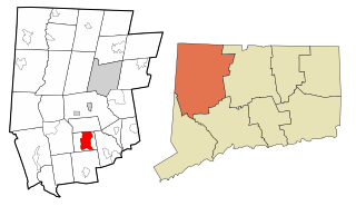
Litchfield County is in northwestern Connecticut, United States. As of the 2020 census, the population was 185,186. The county was named after Lichfield, in England. Litchfield County has the lowest population density of any county in Connecticut and is the state's largest county by area.

<span class="mw-page-title-main">Hazardville, Connecticut</span> Census-designated place in Connecticut, United States

Hazardville is a section of the town of Enfield, Connecticut, in Hartford County. It is a census-designated place (CDP) that had a total population of 4,599 as of the 2010 census.

<span class="mw-page-title-main">Bethlehem, Connecticut</span> Town in Connecticut, United States

Bethlehem is a town in Litchfield County, Connecticut, United States. The population was 3,385 at the 2020 census, down from 3,607 at the 2010 census. The town is part of the Naugatuck Valley Planning Region. The town center is a historic district and a census-designated place (CDP).

<span class="mw-page-title-main">Colebrook, Connecticut</span> Town in Connecticut, United States

Colebrook is a town in Litchfield County, Connecticut, United States. The population was 1,361 at the 2020 census. The town is part of the Northwest Hills Planning Region. Colebrook was named after Colebrooke in the English county of Devon; the reason is now unknown.

<span class="mw-page-title-main">Norfolk, Connecticut</span> Town in Connecticut, United States

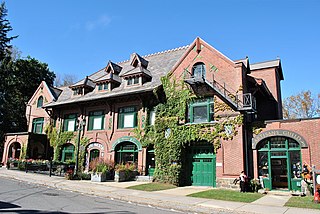
Norfolk is a town in Litchfield County, Connecticut, United States. The population was 1,588 at the 2020 census. The town is part of the Northwest Hills Planning Region. The urban center of the town is the Norfolk census-designated place, with a population of 553 at the 2010 census.

<span class="mw-page-title-main">North Canaan, Connecticut</span> Town in Connecticut, United States

North Canaan is a town in Litchfield County, Connecticut, United States. The population was 3,211 at the 2020 census. The town is part of the Northwest Hills Planning Region. The town center is still called "Canaan", being the main town center of the old town of Canaan prior to North Canaan splitting off as its own town.

<span class="mw-page-title-main">Northwest Harwinton, Connecticut</span> Census-designated place in Connecticut, United States

Northwest Harwinton is a census-designated place (CDP) in the town of Harwinton in Litchfield County, Connecticut, United States. The population was 3,158 at the 2020 census, out of 5,484 in the entire town. The CDP contains the town center.

<span class="mw-page-title-main">Oakville, Connecticut</span> Census-designated place in Connecticut, United States

Oakville is a census-designated place (CDP) and neighborhood section of Watertown, in Litchfield County, Connecticut, United States. The population was 9,047 as of the 2010 census. It is the most populous community in Watertown, with more than twice as many people as the center village of Watertown. The ZIP code for Oakville is 06779.

<span class="mw-page-title-main">Roxbury, Connecticut</span> Town in Connecticut, United States

Roxbury is a town in Litchfield County, Connecticut, United States. The population was 2,260 at the 2020 census. The town is located 65 miles (105 km) northeast of New York City, and is part of the Northwest Hills Planning Region.

<span class="mw-page-title-main">Warren, Connecticut</span> Town in Connecticut, United States

Warren is a town in Litchfield County, Connecticut, United States. The population was 1,351 at the 2020 census. The town is part of the Northwest Hills Planning Region. The town was named for Revolutionary War General Joseph Warren.

<span class="mw-page-title-main">Fenwick, Connecticut</span> Borough in Connecticut, United States

Fenwick is a borough in Middlesex County, Connecticut, United States, in the town of Old Saybrook. The borough is part of the Lower Connecticut River Valley Planning Region. The population was 53 at the 2020 census, making it the least populous borough in Connecticut. Most of the borough is included in the Fenwick Historic District, listed on the National Register of Historic Places. In 1995, the district included 66 contributing buildings and one other contributing site.

<span class="mw-page-title-main">Higganum, Connecticut</span> Census-designated place in Connecticut, United States

Higganum is a village and census-designated place (CDP) in the town of Haddam, a part of Middlesex County, Connecticut, United States. The population was 2,089 at the 2020 census.

<span class="mw-page-title-main">Danielson, Connecticut</span> Borough in Connecticut, United States

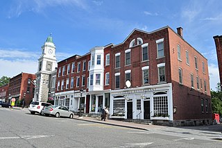
Danielson is a borough in the town of Killingly in Windham County, Connecticut, United States. The population was 4,155 at the 2020 census.

<span class="mw-page-title-main">Penn Township, Lancaster County, Pennsylvania</span> Township in Pennsylvania, United States

Penn Township is a township that is located in north central Lancaster County, Pennsylvania, United States. The population was 10,224 at the time of the 2020 census.

<span class="mw-page-title-main">Trappe, Pennsylvania</span> Borough in Pennsylvania, United States

Trappe is a borough in Montgomery County, Pennsylvania, United States. The population was 3,509 at the 2010 census. Augustus Lutheran Church, built in 1743, is the oldest unchanged Lutheran church building in the United States in continuous use by the same congregation. It has been designated a National Historic Landmark.

<span class="mw-page-title-main">Wilder, Vermont</span> Census-designated place in Vermont, United States

Wilder is an unincorporated village and census-designated place (CDP) within the town of Hartford in Windsor County, Vermont, United States. It is the location of the Wilder Dam on the Connecticut River. The population of the CDP was 1,690 at the 2010 census. The village center is an early example of a planned mill community, and was listed on the National Register of Historic Places as the Wilder Village Historic District in 1999.

<span class="mw-page-title-main">Litchfield, Connecticut</span> Town in Connecticut, United States

Litchfield is a town in and former county seat of Litchfield County, Connecticut, United States. The population was 8,192 at the 2020 census. The town is part of the Northwest Hills Planning Region. The boroughs of Bantam and Litchfield are located within the town. There are also three unincorporated villages: East Litchfield, Milton, and Northfield. Northfield, located in the southeastern corner of Litchfield, is home to a high percentage of the Litchfield population.

<span class="mw-page-title-main">Bethlehem Village, Connecticut</span> Census-designated place in Connecticut, United States

Bethlehem Village is a census-designated place (CDP) within the town of Bethlehem in Litchfield County, Connecticut, United States. The CDP includes the Bethlehem Green Historic District at the town center, as well as surrounding residential and rural land. As of the 2010 census, the CDP had a population of 2,021, out of a population of 3,607 for the entire town of Bethlehem.

<span class="mw-page-title-main">Newtown (borough), Connecticut</span> Borough in Connecticut, United States

Newtown is a borough in Fairfield County, Connecticut, United States, within the town of Newtown. The population was 1,941 at the 2010 census.

<span class="mw-page-title-main">Canaan (village), Connecticut</span> United States historic place

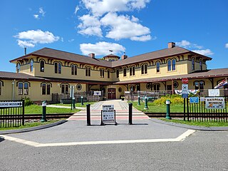
Canaan is a village and census-designated place (CDP) within the town of North Canaan in Litchfield County, Connecticut, United States. Formerly known as Canaan Depot, the village is more commonly known as Canaan Village to distinguish it from the town of Canaan located to the south of North Canaan. The Canaan Village Historic District is listed on the National Register of Historic Places. As of the 2010 census, the CDP had a population of 1,212, out of a total population of 3,315 in the town of North Canaan.

References

  1. 1 2 "Geographic Identifiers: 2010 Census Summary File 1 (G001), Litchfield borough, Connecticut". American FactFinder. U.S. Census Bureau. Archived from the original on February 13, 2020. Retrieved October 21, 2019.
  2. 1 2 3 Borough of Litchfield Historic District Commission, Town of Litchfield website, accessed January 28, 2010
  3. 1 2 "National Register Information System". National Register of Historic Places . National Park Service. March 13, 2009.
  4. "Litchfield Historic District". National Historic Landmark summary listing. National Park Service. Archived from the original on June 14, 2012. Retrieved October 3, 2007.
  5. David F. Ransom (January 12, 1978). "National Register of Historic Places Inventory-Nomination: Litchfield Historic District (borough)". National Park Service. and Accompanying 23 photos, from 1977
  6. "U.S. Census website". United States Census Bureau . Retrieved January 31, 2008.