Watertown (CDP), Connecticut

Last updated
Watertown, Connecticut
Main Street, Watertown CT.jpg
Main Street
Litchfield County Connecticut Incorporated and Unincorporated areas Watertown (CDP) Highlighted 2010.svg
Location in Litchfield County, Connecticut
Coordinates: 41°36′21″N73°7′5″W / 41.60583°N 73.11806°W / 41.60583; -73.11806
State Connecticut
County Litchfield
Town Watertown
Area
  Total2.12 sq mi (5.50 km2)
  Land2.12 sq mi (5.49 km2)
  Water0.004 sq mi (0.01 km2)
Elevation
583 ft (178 m)
Population
 (2010)
  Total3,574
  Density1,687/sq mi (651.2/km2)
ZIP Code
06795
FIPS code 09-80420
GNIS feature ID2631578

Watertown is a census-designated place (CDP) in Litchfield County, Connecticut, United States. It comprises the central village of the town of Watertown. As of the 2010 census, the population of the CDP was 3,574, [1] out of 22,514 in the entire town. As of the 2020 Census, the population was 22,105.

Contents

Geography

The Watertown CDP is slightly south of the geographic center of the town of Watertown, on a hill rising to the west of Steele Brook, a southeast-flowing tributary of the Naugatuck River. The CDP is bordered to the southeast by the community of Oakville, the most populous place in Watertown. The Watertown CDP extends to the south as far as the junction of Connecticut Routes 63 and 73; to the west as far as Middlebury Road, Hamilton Lane, and Guernseytown Road; to the north as far as West Road and Merriam Lane; and to the east to Porter Street, Westbury Park Road, and French Street. [2]

U.S. Route 6 follows Cutler Street, Deforest Street, and Woodbury Road through the center of the community; it leads northeast 5 miles (8 km) to Thomaston and southwest 7 miles (11 km) to Woodbury. Connecticut Route 63 is Watertown's Main Street; it leads north 10 miles (16 km) to Litchfield and south five miles to Interstate 84 at the western border of Waterbury. Downtown Waterbury is five miles to the southeast of Watertown via Routes 63 and 73.

According to the U.S. Census Bureau, the Watertown CDP has a total area of 2.1 square miles (5.5 km2), of which 0.00 square miles (0.01 km2), or 0.23%, are water. [3]

Demographics

As of the census of 2010, there were 3,574 people, 1,487 households, and 972 families residing in the CDP. The population density was 1,687 inhabitants per square mile (651/km2). There were 1,563 housing units, of which 76, or 4.9%, were vacant. The racial makeup of the CDP was 96.0% White, 1.1% African American, 0.3% American Indian or Alaska Native, 0.9% Asian, 0.7% some other race, and 1.0% from two or more races. Hispanic or Latino of any race were 2.8% of the population. [1]

Of the 1,487 households in the community, 27.3% had children under the age of 18 living with them, 51.0% were headed by married couples living together, 10.7% had a female householder with no husband present, and 34.6% were non-families. 30.1% of all households were made up of individuals, and 12.2% were someone living alone who was 65 years of age or older. The average household size was 2.34, and the average family size was 2.92. [1]

20.2% of the CDP population were under the age of 18, 6.6% were from 18 to 24, 24.5% were from 25 to 44, 32.3% were from 45 to 64, and 16.3% were 65 years of age or older. The median age was 44.1 years. For every 100 females, there were 92.0 males. For every 100 females age 18 and over, there were 89.9 males. [1]

For the period 2013-17, the estimated median annual income for a household in the CDP was $71,250, and the median income for a family was $102,000. Male full-time workers had a median income of $57,385 versus $41,723 for females. About 0% of families and 6.3% of the population were living below the poverty line, including 5.1% of those age 65 or over. [4]

Related Research Articles

<span class="mw-page-title-main">Litchfield County, Connecticut</span> County in Connecticut, United States

Litchfield County is in northwestern Connecticut, United States. As of the 2020 census, the population was 185,186. The county was named after Lichfield, in England. Litchfield County has the lowest population density of any county in Connecticut and is the state's largest county by area.

<span class="mw-page-title-main">Bethlehem, Connecticut</span> Town in Connecticut, United States

Bethlehem is a town in Litchfield County, Connecticut, United States. The population was 3,385 at the 2020 census, down from 3,607 at the 2010 census. The town is part of the Naugatuck Valley Planning Region. The town center is a historic district and a census-designated place (CDP).

<span class="mw-page-title-main">New Hartford, Connecticut</span> Town in Connecticut, United States

New Hartford is a town in Litchfield County, Connecticut, United States. The population was 6,658 at the 2020 census. The town is part of the Northwest Hills Planning Region. The town center is defined by the U.S. Census Bureau as the New Hartford Center census-designated place (CDP). The town is mainly a rural community consisting of farms, homes, and parks. Brodie Park and Ski Sundown are located in New Hartford.

<span class="mw-page-title-main">Northwest Harwinton, Connecticut</span> Census-designated place in Connecticut, United States

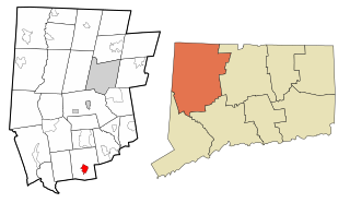
Northwest Harwinton is a census-designated place (CDP) in the town of Harwinton in Litchfield County, Connecticut, United States. The population was 3,158 at the 2020 census, out of 5,484 in the entire town. The CDP contains the town center.

<span class="mw-page-title-main">Oakville, Connecticut</span> Census-designated place in Connecticut, United States

Oakville is a census-designated place (CDP) and neighborhood section of Watertown, in Litchfield County, Connecticut, United States. The population was 9,047 as of the 2010 census. It is the most populous community in Watertown, with more than twice as many people as the center village of Watertown. The ZIP code for Oakville is 06779.

<span class="mw-page-title-main">Plymouth, Connecticut</span> Town in Connecticut, United States

Plymouth is a town in Litchfield County, Connecticut, United States, located within the Naugatuck Valley Planning Region. It is named after Plymouth, Devon, England. The population was 11,671 at the 2020 census, down from 12,243 at the 2010 census. The town of Plymouth includes the villages of Plymouth Center, Terryville and Pequabuck.

<span class="mw-page-title-main">Roxbury, Connecticut</span> Town in Connecticut, United States

Roxbury is a town in Litchfield County, Connecticut, United States. The population was 2,260 at the 2020 census. The town is located 65 miles (105 km) northeast of New York City, and is part of the Northwest Hills Planning Region.

<span class="mw-page-title-main">Terryville, Connecticut</span> Census-designated place in Plymouth, Connecticut, US

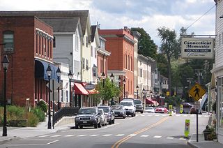
Terryville is a census-designated place (CDP) in Litchfield County, Connecticut, United States, and is the largest village within the town of Plymouth. In the 2010 census, Terryville had a population of 5,387, out of 12,243 in the entire town of Plymouth. The village is named for Eli Terry Jr., the son of the well-known clockmaker Eli Terry Sr. Terryville is also home to the Lock Museum of America. There is a water wheel located in downtown Terryville that is dedicated to the son of Eli Terry Sr.

<span class="mw-page-title-main">Thomaston, Connecticut</span> Town in Connecticut, United States

Thomaston is a town in Litchfield County, Connecticut, United States. The town is part of the Naugatuck Valley Planning Region. The population was 7,442 at the 2020 census. The urban center of the town is the Thomaston census-designated place, with a population of 1,928 at the 2020 census.

<span class="mw-page-title-main">Watertown, Connecticut</span> Town in Connecticut, United States

Watertown is a town in Litchfield County, Connecticut, United States. The town is part of the Naugatuck Valley Planning Region. The population was 22,105 at the 2020 census. The ZIP Codes for Watertown are 06795 and 06779. It is a suburb of Waterbury. The urban center of the town is the Watertown census-designated place, with a population of 3,938 at the 2020 census.

<span class="mw-page-title-main">Woodbury, Connecticut</span> Town in Connecticut, United States

Woodbury is a town in Litchfield County, Connecticut, United States. The town is part of the Naugatuck Valley Planning Region. The population was 9,723 at the 2020 census. The town center, comprising the adjacent villages of Woodbury and North Woodbury, is designated by the U.S. Census Bureau as the Woodbury Center census-designated place (CDP). Woodbury was founded in 1673.

<span class="mw-page-title-main">Middlebury, Connecticut</span> Town in Connecticut, United States

Middlebury is a town in New Haven County, Connecticut, United States. The population was 7,574 at the 2020 census. The town is part of the Naugatuck Valley Planning Region.

<span class="mw-page-title-main">Ridgefield (CDP), Connecticut</span> Census-designated place in Connecticut, United States

Ridgefield is a census-designated place (CDP) in Fairfield County, Connecticut, United States. It consists of the primary central village in the town of Ridgefield and surrounding residential areas. As of the 2020 census, the population of the CDP was 7,596, out of 25,053 in the entire town.

<span class="mw-page-title-main">New Milford (CDP), Connecticut</span> Census-designated place in Connecticut, United States

Downtown New Milford is a district/census-designated place (CDP) in Litchfield County, Connecticut, United States. It comprises the main population center within the town of New Milford. As of the 2010 census, the population of Downtown New Milford was 6,523, out of 28,142 in the entire town of New Milford.

<span class="mw-page-title-main">Bethlehem Village, Connecticut</span> Census-designated place in Connecticut, United States

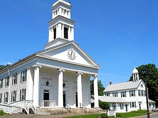
Bethlehem Village is a census-designated place (CDP) within the town of Bethlehem in Litchfield County, Connecticut, United States. The CDP includes the Bethlehem Green Historic District at the town center, as well as surrounding residential and rural land. As of the 2010 census, the CDP had a population of 2,021, out of a population of 3,607 for the entire town of Bethlehem.

<span class="mw-page-title-main">New Hartford Center, Connecticut</span> Census-designated place in Connecticut, United States

New Hartford Center is a census-designated place (CDP) in Litchfield County, Connecticut, United States. It comprises the village of New Hartford, the adjacent Pine Meadow Historic District, and some surrounding forest land, all within the town of New Hartford. As of the 2010 census, the population of New Hartford Center was 1,385, out of 6,970 in the entire town of New Hartford.

<span class="mw-page-title-main">Woodbury Center, Connecticut</span> Census-designated place in Connecticut, United States

Woodbury Center is a census-designated place (CDP) in Litchfield County, Connecticut, United States. It comprises the twin villages of Woodbury and North Woodbury and surrounding residential land in the town of Woodbury. As of the 2010 census, the population of the CDP was 1,294, out of 9,975 in the entire town.

<span class="mw-page-title-main">Canaan (village), Connecticut</span> United States historic place

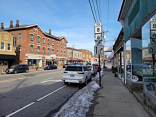
Canaan is a village and census-designated place (CDP) within the town of North Canaan in Litchfield County, Connecticut, United States. Formerly known as Canaan Depot, the village is more commonly known as Canaan Village to distinguish it from the town of Canaan located to the south of North Canaan. The Canaan Village Historic District is listed on the National Register of Historic Places. As of the 2010 census, the CDP had a population of 1,212, out of a total population of 3,315 in the town of North Canaan.

<span class="mw-page-title-main">Norfolk (CDP), Connecticut</span> Census-designated place in Connecticut, United States

Norfolk is a census-designated place (CDP) in Litchfield County, Connecticut, United States. It is the central village within the town of Norfolk. As of the 2010 census, the population of the CDP was 553, out of 1,709 in the entire town.

<span class="mw-page-title-main">Thomaston (CDP), Connecticut</span> Census-designated place in Connecticut, United States

Thomaston is a census-designated place (CDP) in Litchfield County, Connecticut, United States. It comprises the downtown portion of the town of Thomaston. As of the 2010 census, the population of the CDP was 1,910, out of 7,887 in the entire town.

References

  1. 1 2 3 4 "Profile of General Population and Housing Characteristics: 2010 Census Summary File 1 (DP-1), Watertown CDP, Connecticut". American FactFinder. U.S. Census Bureau. Archived from the original on February 13, 2020. Retrieved November 1, 2019.
  2. "TIGERweb: Watertown CDP, Connecticut". Geography Division, U.S. Census Bureau. Retrieved November 1, 2019.
  3. "U.S. Gazetteer Files: 2019: Places: Connecticut". U.S. Census Bureau Geography Division. Retrieved November 1, 2019.
  4. "Watertown (CDP), Connecticut". data.census.gov. Retrieved November 1, 2019.