Bantam, Connecticut

Last updated

Bantam, Connecticut
Borough of Bantam
PostcardBantamCTSouthStreetca1910.jpg
South Street, about 1910 (postcard picture)
Litchfield County Connecticut Incorporated and Unincorporated areas Bantam Highlighted 2010.svg
Location in Litchfield County, Connecticut
Coordinates: 41°43′24″N73°14′26″W / 41.72333°N 73.24056°W / 41.72333; -73.24056
CountryFlag of the United States.svg  United States
U.S. state Flag of Connecticut.svg  Connecticut
County Litchfield
Region Northwest Hills
Town Litchfield
Area
[1]
  Total1.01 sq mi (2.62 km2)
  Land1.01 sq mi (2.62 km2)
  Water0.00 sq mi (0.00 km2)
Elevation
922 ft (281 m)
Population
 (2020)
  Total720
  Density719.80/sq mi (277.82/km2)
Time zone UTC-5 (Eastern (EST))
  Summer (DST) UTC-4 (EDT)
ZIP code
06750
Area code 860
FIPS code 09-02690
GNIS feature ID0205245
Website bantamct.org

Bantam is a borough in Litchfield County, Connecticut, United States. The population was 720 at the 2020 census. It is part of the town of Litchfield.

Contents

On July 10, 1989, many of the buildings in Bantam were heavily damaged by a tornado that ripped through Litchfield and New Haven Counties. The storm also caused considerable damage to the Litchfield County town of Thomaston, and to the New Haven County towns of Waterbury, Hamden and North Haven.

Geography

According to the United States Census Bureau, the borough has a total area of 1.0 square mile (2.6 km2), all land.

Climate

This climatic region is typified by large seasonal temperature differences, with warm to hot (and often humid) summers and cold (sometimes severely cold) winters. According to the Köppen Climate Classification system, Bantam has a humid continental climate, abbreviated "Dfb" on climate maps. [2]

Demographics

Historical population
CensusPop.Note
1920 608
1930 545−10.4%
1940 5643.5%
1950 94066.7%
1960 833−11.4%
1970 8815.8%
1980 860−2.4%
1990 757−12.0%
2000 8025.9%
2010 759−5.4%
2020 720−5.1%
U.S. Decennial Census [3]

As of the 2010 census Bantam had a population of 759. The racial composition of the population was 96.6% white, 1.2% black or African American, 0.3% from other races and 1.8% from two or more races. 3.3% of the population was Hispanic or Latino of any race. [4]

At the 2000 census there were 802 people, 364 households, and 202 families residing in the borough. The population density was 793.4 inhabitants per square mile (306.3/km2). There were 376 housing units at an average density of 372.0 per square mile (143.6/km2). The racial makeup of the borough was 96.01% White, 0.37% African American, 0.50% Native American, 0.75% Asian, 0.87% from other races, and 1.50% from two or more races. Hispanic or Latino of any race were 2.00%. [5]

Of the 364 households, 28.0% had children under the age of 18 living with them, 44.2% were married couples living together, 6.9% had a female householder with no husband present, and 44.5% were non-families. 40.1% of households were one person, and 25.0% were one person aged 65 or older. The average household size was 2.20 and the average family size was 3.04.

In the borough the population was spread out, with 25.8% under the age of 18, 3.0% from 18 to 24, 28.8% from 25 to 44, 22.1% from 45 to 64, and 20.3% 65 or older. The median age was 42 years. For every 100 females, there were 83.9 males. For every 100 females age 18 and over, there were 84.8 males.

The median household income was $32,167 and the median family income was $50,938. Males had a median income of $42,000 versus $30,385 for females. The per capita income for the borough was $18,442. About 3.1% of families and 5.4% of the population were below the poverty line, including 3.1% of those under age 18 and 10.3% of those age 65 or over.

Common ancestries reported were: Irish (21.1%), Italian (14.5%), German (14.0%), English (13.1%), French Canadian (10.1%), French (9.7%).

Education

Residents are zoned to Litchfield Public Schools, including Litchfield High School.

Related Research Articles

<span class="mw-page-title-main">Litchfield County, Connecticut</span> County in Connecticut, United States

Litchfield County is in northwestern Connecticut, United States. As of the 2020 census, the population was 185,186. The county was named after Lichfield, in England. Litchfield County has the lowest population density of any county in Connecticut and is the state's largest county by area.

<span class="mw-page-title-main">Bethlehem, Connecticut</span> Town in Connecticut, United States

Bethlehem is a town in Litchfield County, Connecticut, United States. The population was 3,385 at the 2020 census, down from 3,607 at the 2010 census. The town is part of the Naugatuck Valley Planning Region. The town center is a historic district and a census-designated place (CDP).

<span class="mw-page-title-main">Northwest Harwinton, Connecticut</span> Census-designated place in Connecticut, United States

Northwest Harwinton is a census-designated place (CDP) in the town of Harwinton in Litchfield County, Connecticut, United States. The population was 3,158 at the 2020 census, out of 5,484 in the entire town. The CDP contains the town center.

<span class="mw-page-title-main">Thomaston, Connecticut</span> Town in Connecticut, United States

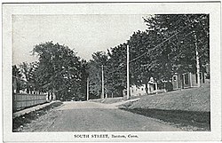
Thomaston is a town in Litchfield County, Connecticut, United States. The town is part of the Naugatuck Valley Planning Region. The population was 7,442 at the 2020 census. The urban center of the town is the Thomaston census-designated place, with a population of 1,928 at the 2020 census.

<span class="mw-page-title-main">Warren, Connecticut</span> Town in Connecticut, United States

Warren is a town in Litchfield County, Connecticut, United States. The population was 1,351 at the 2020 census. The town is part of the Northwest Hills Planning Region. The town was named for Revolutionary War General Joseph Warren.

<span class="mw-page-title-main">Bethany, Connecticut</span> Town in Connecticut, United States

Bethany is a town in New Haven County, Connecticut, United States. The town is part of the South Central Connecticut Planning Region. The population was 5,297 at the 2020 census.

<span class="mw-page-title-main">Highland Park, Florida</span> Village in Florida, United States

Highland Park is a village in Polk County, Florida, United States. Highland Park is part of the Lakeland–Winter Haven Metropolitan Statistical Area. Its population was 251 at the 2020 US census.

<span class="mw-page-title-main">Onaga, Kansas</span> City in Pottawatomie County, Kansas

Onaga is a city in Pottawatomie County, Kansas, United States. As of the 2020 census, the population of the city was 679.

<span class="mw-page-title-main">Litchfield, Michigan</span> City in Michigan, United States

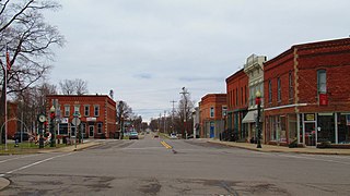
Litchfield is a city in Hillsdale County in the U.S. state of Michigan. The population was 1,399 at the 2020 census.

<span class="mw-page-title-main">Franklin Township, Beaver County, Pennsylvania</span> Township in Pennsylvania, United States

Franklin Township is a township in Beaver County, Pennsylvania, United States. The population was 3,885 at the 2020 census. It is part of the Pittsburgh metropolitan area.

<span class="mw-page-title-main">Silverdale, Pennsylvania</span> Borough in Pennsylvania, United States

Silverdale is a borough in Bucks County, Pennsylvania, United States. The population was 871 at the 2010 census.

<span class="mw-page-title-main">South Coatesville, Pennsylvania</span> Borough in Pennsylvania, United States

South Coatesville is a borough that is located in Chester County, Pennsylvania, United States. The population was 1,604 at the time of the 2020 census.

<span class="mw-page-title-main">Coal Center, Pennsylvania</span> Borough in Pennsylvania, United States

Coal Center is a borough on the Monongahela River in Washington County, Pennsylvania, United States and part of the Pittsburgh metropolitan area since 1950. The population was 110 at the 2020 census.

<span class="mw-page-title-main">York Haven, Pennsylvania</span> Borough in Pennsylvania, United States

York Haven is a borough in York County, Pennsylvania, United States. The population was 691 at the 2020 census. It is part of the York–Hanover metropolitan area. The borough is the home of the Brunner Island coal-fired electrical generation plant, located on the Susquehanna River on Wago Road and operated by PPL Corporation.

<span class="mw-page-title-main">Stockdale, Texas</span> City in Texas, United States

Stockdale is a city in Wilson County, Texas, United States. The population was 1,413 at the 2020 census. It is part of the San Antonio Metropolitan Statistical Area.

<span class="mw-page-title-main">New Haven, West Virginia</span> Town in West Virginia, United States

New Haven is a town in Mason County, West Virginia, United States, along the Ohio River. The population was 1,485 at the 2020 census. It is part of the Point Pleasant, WV–OH Micropolitan Statistical Area.

<span class="mw-page-title-main">Lunenburg (CDP), Massachusetts</span> CDP in Massachusetts, United States

Lunenburg is a census-designated place (CDP) in the town of Lunenburg in Worcester County, Massachusetts, United States. The population was 1,760 at the 2010 census.

<span class="mw-page-title-main">Litchfield, Connecticut</span> Town in Connecticut, United States

Litchfield is a town in and former county seat of Litchfield County, Connecticut, United States. The population was 8,192 at the 2020 census. The town is part of the Northwest Hills Planning Region. The boroughs of Bantam and Litchfield are located within the town. There are also three unincorporated villages: East Litchfield, Milton, and Northfield. Northfield, located in the southeastern corner of Litchfield, is home to a high percentage of the Litchfield population.

<span class="mw-page-title-main">Newtown (borough), Connecticut</span> Borough in Connecticut, United States

Newtown is a borough in Fairfield County, Connecticut, United States, within the town of Newtown. The population was 1,941 at the 2010 census.

<span class="mw-page-title-main">Litchfield (borough), Connecticut</span> Borough in Connecticut, United States

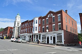
Litchfield is a borough in, and the village center of, the town of Litchfield in Litchfield County, Connecticut, United States. The population was 1,258 at the 2010 census. The entire borough was designated a Connecticut historic district in 1959 by special act of the state General Assembly and is listed on the National Register of Historic Places. Part of the borough is also a National Historic Landmark, the Litchfield Historic District.

References

  1. "2019 U.S. Gazetteer Files". United States Census Bureau. Retrieved July 2, 2020.
  2. Climate Summary for Bantam, Connecticut
  3. "Census of Population and Housing". Census.gov. Retrieved June 4, 2015.
  4. 2010 population by race and Hispanic or Latino by place chart for Connecticut from the US Census
  5. "U.S. Census website". United States Census Bureau . Retrieved January 31, 2008.

41°43′28″N73°14′10″W / 41.72444°N 73.23611°W / 41.72444; -73.23611