East Lyme, Connecticut

Last updated

East Lyme, Connecticut
Town of East Lyme
Bride-Brook-Salt-Marsh-s.jpg
Salt marsh in East Lyme
EastLymeCTseal.gif
New London County Connecticut Incorporated and Unincorporated areas East Lyme Highlighted 2010.svg
East Lyme, Connecticut
Coordinates: 41°21′11″N72°13′46″W / 41.35306°N 72.22944°W / 41.35306; -72.22944
CountryFlag of the United States.svg  United States
U.S. state Flag of Connecticut.svg  Connecticut
County New London
Region Southeastern CT
Incorporated1839
Government
  Type Selectman-town meeting
  First selectmanDan Cunningham (D)
Area
  Total42.0 sq mi (108.8 km2)
  Land34.0 sq mi (88.1 km2)
  Water7.9 sq mi (20.6 km2)
Elevation
210 ft (64 m)
Population
 (2020)
  Total18,693
  Density450/sq mi (170/km2)
Time zone UTC-5 (Eastern)
  Summer (DST) UTC-4 (Eastern)
ZIP Codes
06333, 06357
Area code(s) 860/959
FIPS code 09-23400
GNIS feature ID0213426
Website eltownhall.com

East Lyme is a town in New London County, Connecticut, United States. The town is part of the Southeastern Connecticut Planning Region. The population was 18,693 at the 2020 census. [1] The villages of Niantic and Flanders are located in the town.

Contents

Geography

View of the Rocky Neck State Park Jetty, beach and the Giants Neck area shoreline in the Niantic section of East Lyme, Connecticut. Rocky Neck SP Beach Niantic CT.jpg
View of the Rocky Neck State Park Jetty, beach and the Giants Neck area shoreline in the Niantic section of East Lyme, Connecticut.

East Lyme is located in southern New London County, west of Waterford and Montville, east of Lyme and Old Lyme, and south of Salem. Long Island Sound is to the south. According to the United States Census Bureau, the town has a total area of 42.0 square miles (109 km2), of which 34.0 square miles (88 km2) is land and 7.9 square miles (20 km2), or 19%, is water.

Villages

The town consists primarily of two villages, Flanders and Niantic. It is common for the town of East Lyme to be erroneously called "Niantic", due to this side of town being the "beach" side which is popular with tourists and visitors in the summer months. Niantic's population doubles in the summer months for the beach season, and it has a much higher density than the more sparsely populated Flanders side of town, which is known for its apple orchards, the town's high school, and the forest.

Niantic

The Morton House Hotel in the village of Niantic has been in continuous operation for more than 100 years. Morton house.JPG
The Morton House Hotel in the village of Niantic has been in continuous operation for more than 100 years.

The village of Niantic gets its name from the Niantic or Nehantic people, whose ranging grounds once extended from Wecapaug Brook, in what is now Rhode Island, to the Connecticut River. Shortly before the first settlers arrived, the Pequots had invaded Nehantic territory and annexed about half of the land claimed by the tribe. According to local historian Olive Tubbs Chendali:

It was the construction of the railroad in 1851 that lured people to the shoreline which up to this time had been known - not as Niantic - but as "The Bank". Long before this time, however, as evidenced by The Diary of Joshua Hempstead - 1711 - 1758 it was known as "Nahantick" "Nyantick" or "Nehantic", the home territory of the Nehantic Indians. [2]

Sportfishing and marinas dominate the village's industry along with summer tourism and restaurant trade. Strong regional businesses include seafood restaurants and hotels/motels serving the town's beaches and the casinos at Foxwoods and Mohegan Sun. Rocky Neck State Park features camping, swimming and picnic areas along with numerous marinas and sportfishing companies.

The Niantic Bay Boardwalk is a one-mile (1.6 km) long walkway that runs parallel to Amtrak’s shoreline railroad tracks and spans Niantic Bay from the Niantic River inlet to Hole-in-the-Wall municipal beach. It first opened to the public in 2005, but was closed from about 2011 due to a combination of Amtrak building a new railroad bridge across the Niantic River, which required a re-positioning of the approach tracks, and damage caused by Hurricane Irene in October 2011. [3] The boardwalk fully re-opened to the public in March 2016. [4]

The Children's Museum of Southeastern Connecticut is located in East Lyme's original public library on Main Street. The museum is aimed primarily at children ages infant to ten years old. The current public library is located on Society Road, away from Niantic.

The village of Niantic includes the beach communities of Attawan Beach, Black Point, Crescent Beach, Giants Neck Beach, Giants Neck Heights, Oak Grove Beach, Old Black Point, Pine Grove, and Saunder's Point.

East Lyme and Niantic station was an Amtrak station that closed in 1981. There are currently proposals to rebuild the station to accommodate Shore Line East trains.

Flanders

The former village, now neighborhood of Flanders, originally a farming area along the Old Post Road, gets its name from the development of woolen mills similar to that in Flanders, Belgium. [5] The heart of the village is located at Flanders Four Corners at the intersection of Chesterfield Road (Route 161) and Boston Post Road (Route 1). This area is the site of many small stores and businesses, as well as East Lyme High School, Flanders Elementary School, and the Board of Education.

Flanders was the original center of East Lyme society with dozens of 18th century homes, shops and public inns situated along the Boston Post Road until the early 1800s. It lost its pre-eminence as Niantic began to flourish, first with the growth of commercial fishing and then with the construction of the Shore Line Railway. [6] Many of the original Flanders homes have been lost as a result of the construction of Interstate 95 in the 1950s and subsequent commercial construction at the Four Corners area. For example, the old Caulkins Tavern stood at the site of the current CVS and was a well-traveled and documented stopping place in the 18th century from none other than Sarah Kemble Knight in her diary, as well as General George Washington, who stopped here with thousands of troops in 1776. [7] Some homes remain closer to the Waterford line at the site of the old Beckwith Shipyard at the head of the Niantic River.


Other minor communities

Golden Spur is a community located at the head of the Niantic River, which earned it its other name, "Head of the River". In the eighteenth century it was the site of the Beckwith shipyard. By the turn of the 20th century it was the site of an amusement park accessible by trolley run by the East Lyme Street Railway. The park operated until 1924. [8]

Topography

The topography of East Lyme consists of rolling hills and lush valleys rounded by glaciers during the last Ice Age. Hills rise to elevations of 250 to 350 feet (76 to 107 m) above sea level in the eastern and central areas of the town. The highest point in town is an unnamed hill with an elevation of 500 feet (150 m) located in Nehantic State Forest in the northwest corner of the town. [9] East Lyme is especially scenic in the summer when the trees are in bloom. On its east and southern sides, the town abuts tidewater. The tidal Niantic River on the east feeds Niantic Bay, an arm of Long Island Sound, which forms the southern edge of the town.

Demographics

Historical population
CensusPop.Note
1850 1,382
1860 1,5069.0%
1870 1,5060.0%
1880 1,73114.9%
1890 2,04818.3%
1900 1,836−10.4%
1910 1,9164.4%
1920 2,29119.6%
1930 2,57512.4%
1940 3,33829.6%
1950 3,87015.9%
1960 6,78275.2%
1970 11,39968.1%
1980 13,87021.7%
1990 15,34010.6%
2000 18,11818.1%
2010 19,1595.7%
2020 18,693−2.4%
U.S. Decennial Census [10]

As of the census [11] of 2000, there were 18,118 people, 6,308 households, and 4,535 families residing in the town. The population density was 532.3 inhabitants per square mile (205.5/km2). There were 7,459 housing units at an average density of 219.2 per square mile (84.6/km2). The racial makeup of the town was 87.29% White, 6.37% African American, 0.44% Native American, 2.82% Asian, 0.04% Pacific Islander, 1.21% from other races, and 1.83% from two or more races. Hispanic or Latino of any race were 4.59% of the population.

There were 6,308 households, out of which 33.1% had children under the age of 18 living with them, 61.0% were married couples living together, 8.4% had a female householder with no husband present, and 28.1% were non-families. 23.3% of all households were made up of individuals, and 8.8% had someone living alone who was 65 years of age or older. The average household size was 2.50 and the average family size was 2.96.

In the town, the population was spread out, with 21.9% under the age of 18, 6.3% from 18 to 24, 33.4% from 25 to 44, 25.8% from 45 to 64, and 12.6% who were 65 years of age or older. The median age was 39 years. For every 100 females, there were 92.7 males. For every 100 females age 18 and over, there were 90.8 males.

The median income for a household in the town was $66,539, and the median income for a family was $74,430. Males had a median income of $53,333 versus $37,162 for females. The per capita income for the town was $28,765. About 1.7% of families and 2.9% of the population were below the poverty line, including 3.0% of those under age 18 and 3.5% of those age 65 or over.

Voter Registration and Party Enrollment as of October 27, 2020 [12]
PartyActive VotersInactive VotersTotal VotersPercentage
Democratic 4,5382014,73932.85%
Republican 3,1411933,33423.11%
Unaffiliated 5,8283376,16542.73%
Minor Parties (Green, Libertarian, Independent) 18191901.32%
Total13,68874014,428100%
Presidential Election Results [13] [14]
Year Democratic Republican Third Parties
2020 62.0%7,29036.4% 4,2851.6% 181
2016 54.0%5,51241.3% 4,2144.7% 474
2012 57.6%5,42641.3% 3,8861.1% 101
2008 60.4%5,96138.7% 3,8190.9% 92
2004 56.1%5,30642.6% 4,0301.3% 120
2000 52.4%4,54640.5% 3,5137.1% 605
1996 48.9%3,77837.1% 2,87014.0% 1,072
1992 40.9%3,42532.5% 2,71726.6% 2,214
1988 44.6% 3,26653.9%3,9541.5% 105
1984 36.0% 2,51363.6%4,4380.4% 21
1980 31.9% 2,19249.8%3,41918.3% 1,254
1976 41.3% 2,64858.1%3,7270.6% 36
1972 30.7% 1,74369.0%3,9180.3% 11
1968 39.2% 1,79754.3%2,4916.5% 297
1964 56.8%2,19543.2% 1,6740.00% 0
1960 35.1% 1,18664.9%2,1980.00% 0
1956 24.4% 65775.6%2,0360.00% 0

Schools

The town's public schools are operated by the East Lyme School District.

The school district consists of one high school, East Lyme High School; one middle school, East Lyme Middle School (grades 5–8); and three elementary schools:

East Lyme High School has been recognized by Newsweek magazine [15] as one of the top 1,000 high schools in the country and by U.S. News & World Report [16] as one of the top 500 high schools in the United States. In 2017, the East Lyme High School earned a National Blue Ribbon Distinction by U.S. Department of Education. The awards are for schools that continue to show high achievement or make strong progress toward closing achievements gaps. [17]

East Lyme High School hosts the East Lyme Aquatic & Fitness Center. The center contains an eight-lane, 25-yard-long (23 m), competition swimming and diving pool, and a fitness facility with Nautilus equipment, free weights, and a cardiovascular line. The facility is used by high school swimming and diving teams as well as being open to the public, on a fee basis, when not in use by the school. East Lyme High School athletic teams have recently won the Class L State Championships in girls volleyball for the 2010 and 2011 seasons, and reached the Class M State Finals in girls tennis in 2012. The baseball team also reached the Class L State finals in 2015 and 2016. The cross country team has achieved unparalleled athletic success at East Lyme, winning three consecutive Class MM State titles in 2017, 2018 & 2019. Students from the neighboring town of Salem also attend East Lyme High School.

The East Lyme Middle School [18] is a 1999–2000 National Blue Ribbon School and a 2004 New England League of Middle Schools Spotlight School. It is also the Connecticut Association of Schools 2013–2014 School of the Year. It includes a high tech computer lab and a spacious library.

The Middle School uses a team program called kivas. A kiva contains a science teacher, a language arts or English teacher, a social studies teacher and a math teacher. Some kivas are smaller and have a math and science teacher and a language arts and social studies teacher. There are 11 kivas consisting of two types: multi-age looping and two-year looping. The last kiva is a world language kiva where students can study French or Spanish.[ citation needed ]

History

Thomas Lee House Thomas Lee House.jpg
Thomas Lee House

The Thomas Lee House, built c.1660, is the oldest house in Connecticut that is still in its primitive state. This building is located in the southwestern section of East Lyme, adjacent to Rocky Neck State Park, at the intersection of Connecticut Route 156 and Giants Neck Road. Co-located on this site is the one-room Little Boston Schoolhouse, which was relocated to its current location from across Route 156. The town features six homes from 1699 or earlier, and the Old Stone Church Burial Ground from 1719 located off Society and Riverview roads.

The area occupied by the town was originally inhabited by the Nehantic people, who maintained villages in the present-day Indian Woods section as well as on Black Point, in the McCook's Beach area and near the Niantic River. The tribe allied itself with the colonists in the 1636 war against the Pequot people. The Nehantic were reported to have died out in the mid-19th century, but there still exist a Nehantic community today. [19] The 1750s Ezra Stiles map shows the Nehantic village in what is now Indian Woods as consisting of "12 or 13 huts".

East Lyme, then a part of Lyme, had several taverns which offered stopping places for travelers such as Sarah Kemble Knight. These included Calkins Tavern on what is now Boston Post Road, Royce's Tavern, and Taber Tavern near present-day I-95. At least 45 Revolutionary War veterans are buried within the borders of East Lyme, and countless more veterans from East Lyme found resting places in upstate New York, New Hampshire and Ohio. Moses Warren, along with General Samuel Holden Parsons originally of Lyme and Moses Cleaveland, set out to survey the Ohio Territory in the latter part of the 1790s and has Warren County, Ohio named after him. [20]

Notable locations

Media

Library

The first library was started in 1888 and was called the Niantic Library and Reading Room Association. There were 65 founding members. In 1897 the library was formally incorporated as "The Niantic Public Library Association" by the state of Connecticut. The library moved a few times until a permanent structure was built in 1920 on Main Street. In 1966 a wing was added, and in 1979 another addition was added. In 1990 the library moved into the new Community Center/Library complex, where it exists today.

Radio

FM station WNLC is based in East Lyme.

Movies

Portions of the made-for-TV movie Disaster on the Coastliner , released 29 October 1979, were filmed in East Lyme. In 2016, East Lyme was used as a filming location for the Lifetime thriller Hunter's Cove, which was renamed Stalker's Prey when it was released on 9 February 2017.

Economy

According to 2009 statistics [21] 42.2 percent of the town's business was focused in the services industry. A service industry is a business that focuses on retail, food services, distribution, and transportation. [22] The second largest sector is the trade industry with 23.1% of the town's business, followed by construction and mining which accounts for 12.5% of the town businesses.

The largest employer in town is the state of Connecticut's Department of Corrections which runs a women's prison in the west end of town, York Correctional Institution. [23] The Gates Correctional Institute for men, also in town, closed in 2011. [24]

Beaches

Hole-in-the-Wall Beach in Niantic, looking west towards McCook Point Hole in the wall NianticCT.JPG
Hole-in-the-Wall Beach in Niantic, looking west towards McCook Point

Public beaches

Private beaches

Notable people

Places of worship

Cemeteries

Active

East Lyme Cemetery Eastlymecemetary fitted to the wiki.png
East Lyme Cemetery

Related Research Articles

<span class="mw-page-title-main">Monroe, Connecticut</span> Town in Connecticut, United States

Monroe is a town located in eastern Fairfield County, Connecticut, United States. The population was 18,825 at the 2020 census. The town is part of the Greater Bridgeport Planning Region.

<span class="mw-page-title-main">Windsor, Connecticut</span> Town in Connecticut, United States

Windsor is a town in Hartford County, Connecticut, United States, and was the first English settlement in the state. It lies on the northern border of Connecticut's capital, Hartford. The town is part of the Capitol Planning Region. The population of Windsor was 29,492 at the 2020 census.

<span class="mw-page-title-main">Branford, Connecticut</span> Town in Connecticut, United States

Branford is a shoreline town located on Long Island Sound in New Haven County, Connecticut, United States, about 6 miles (10 km) east of downtown New Haven. The town is part of the South Central Connecticut Planning Region. Branford borders East Haven to the west, Guilford to the east, and North Branford to the north. The population was 28,273 in the 2020 census.

<span class="mw-page-title-main">Lyme, Connecticut</span> Town in the United States

Lyme is a town in New London County, Connecticut, United States, situated on the eastern side of the Connecticut River. The town is part of the Lower Connecticut River Valley Planning Region. The population was 2,352 at the 2020 census. Lyme is the eponym of Lyme disease.

<span class="mw-page-title-main">Niantic, Connecticut</span> Census-designated place in Connecticut, United States

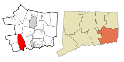
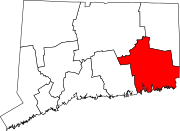
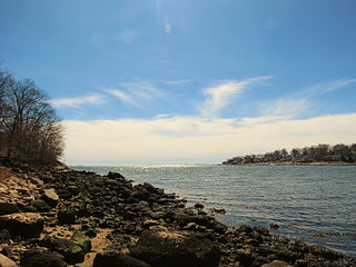
Niantic is a census-designated place (CDP) and village in the town of East Lyme, Connecticut in the United States. The population was 3,114 at the 2010 census. It is located on Long Island Sound, the Millstone Nuclear Power Plant in nearby Waterford is visible on the bay's eastern horizon line, Rocky Neck State Park is also located in the area. Niantic was once famous for its Niantic River scallops, but the scallop population has been in decline for a number of years.

<span class="mw-page-title-main">Old Lyme, Connecticut</span> Town in Connecticut, United States

Old Lyme is a coastal town in New London County, Connecticut, United States, bounded on the west by the Connecticut River, on the south by the Long Island Sound, on the east by the town of East Lyme, and on the north by the town of Lyme. The town is part of the Lower Connecticut River Valley Planning Region.

<span class="mw-page-title-main">Niantic people</span> Historic Native American tribe in Connecticut

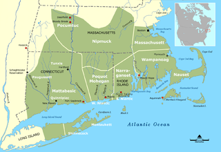
The Niantic are a tribe of Algonquian-speaking American Indians who lived in the area of Connecticut and Rhode Island during the early colonial period. They were divided into eastern and western groups due to intrusions by the more numerous and powerful Pequots. The Western Niantics were subject to the Pequots and lived just east of the mouth of the Connecticut River, while the Eastern Niantics became very close allies to the Narragansetts. It is likely that the name Nantucket is derived from the tribe's endonym, Nehantucket.

<span class="mw-page-title-main">Shore Line East</span> Commuter rail service in southern Connecticut, US

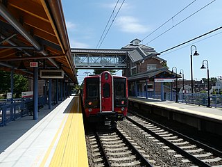
Shore Line East (SLE) is a commuter rail service which operates along the Northeast Corridor through southern Connecticut, United States. The rail service is a fully owned subsidiary of the Connecticut Department of Transportation (CTDOT) and is operated under the CT Rail brand. SLE provides service seven days a week along the Northeast Corridor between New London and New Haven; limited through service west of New Haven to Bridgeport and Stamford has been suspended since 2020. Cross-platform transfers to Metro-North Railroad New Haven Line trains are available at New Haven for service to southwestern Connecticut and New York City. Pre-COVID, around 2,200 riders used the service on weekdays.

<span class="mw-page-title-main">Rocky Neck State Park</span> Public recreation area in Connecticut, US

Rocky Neck State Park is a public recreation area on Long Island Sound in the town of East Lyme, Connecticut, United States. The state park's 708 acres (287 ha) include a tidal river, a broad salt marsh, white sand beaches, rocky shores, and a large stone pavilion dating from the 1930s. It is managed by the Connecticut Department of Energy and Environmental Protection.

<span class="mw-page-title-main">Connecticut Route 161</span> State highway in New London County, Connecticut, US

Route 161 is a state highway in southeastern Connecticut, running from the shoreline village of Niantic in East Lyme to the village of Chesterfield in Montville.

East Lyme Public Schools is a school district in East Lyme, Connecticut.

<span class="mw-page-title-main">Niantic River Bridge</span> Bridge in East Lyme and Waterford, Connecticut

Niantic River Bridge, also known as Amtrak Bascule Bridge No. 116.74, is a railroad bridge carrying Amtrak's Northeast Corridor line across the Niantic River between East Lyme and Waterford, Connecticut. It is a drawbridge with a bascule-type draw span. A new bridge was constructed in 2012 to replace the former span built in 1907. It opened on September 8, 2012. Related construction work finished in June 2013.

<span class="mw-page-title-main">McCook Park Beach</span>

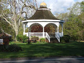
McCook Point is a public park and beach located in the village of Niantic in the town of East Lyme. It adjoins the town's Hole in the Wall Beach to its east and the private Crescent Beach to its west. Combined, the two parks encompass 21 acres of land, the bulk of which is within the section known as McCook Point Park.

<span class="mw-page-title-main">Nehantic Trail</span>

The Nehantic Trail is a 13-mile (21 km) Connecticut hiking trail and is one of the Blue-Blazed hiking trails maintained by the Connecticut Forest and Park Association.

<span class="mw-page-title-main">Pachaug Trail</span>

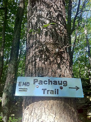
The Pachaug Trail is a 28-mile (45 km) Connecticut hiking trail and is one of the Blue-Blazed hiking trails maintained by the Connecticut Forest and Park Association. It is a horseshoe shaped trail.

<span class="mw-page-title-main">Nehantic State Forest</span>

Nehantic State Forest is a publicly owned forest and recreation area occupying two parcels, one in the town of Lyme and one in the towns of East Lyme and Salem, in the state of Connecticut. The forest, which totals 5,062 acres (2,049 ha), is the site of regular prescribed burns and timber-harvesting operations. Purchase of the land began in 1926, when it became the first state forest located in New London County. It is managed by the Connecticut Department of Energy and Environmental Protection.

<span class="mw-page-title-main">New London and East Lyme Street Railway</span> Connecticut streetcar line

The New London and East Lyme Street Railway was a streetcar line that operated in southeastern Connecticut. Its main line ran from New London to Niantic with a later extension to Crescent Beach and a branch to Old Saybrook.

<span class="mw-page-title-main">Niantic station</span> Former train station in Connecticut, United States

Niantic was a train station on the Northeast Corridor located in the Niantic village of East Lyme, Connecticut. Opened in the 1850s, it was rebuilt in 1899 and again in 1954 by the New Haven Railroad. It closed in 1972, then reopened from 1978 to 1981 for use by the Amtrak Beacon Hill. A new station has since been proposed to be built in Niantic to serve the Shore Line East commuter rail service.

<span class="mw-page-title-main">Nayantaquit Trail</span> US hiking trail

The Nayantaquit Trail is a 7-mile (11 km) Blue-Blazed hiking trail system in Lyme Connecticut and is entirely in the Nehantic State Forest western block. Parking for the trail can be found at several locations on Keeny Road inside the state forest.

References

  1. "Census - Geography Profile: East Lyme town, New London County, Connecticut". United States Census Bureau . Retrieved December 15, 2021.
  2. Chendali, Olive Tubbs. Stories of East Lyme. East Lyme, CT: East Lyme Public Library. pp. 13–14.
  3. "Boardwalk closed in East Lyme". WTNH - News 8. Archived from the original on October 7, 2011. Retrieved March 27, 2012.
  4. "Niantic Bay Boardwalk restored". WTNH - News 8. March 24, 2016. Retrieved April 24, 2016.
  5. Chendali, Olive Tubbs (1989). East Lyme: Our Town and How It Grew. Mystic, CT: Mystic Publications. p. 142.
  6. "About East Lyme". East Lyme Historical Society. Archived from the original on June 27, 2018. Retrieved April 24, 2016.
  7. Chendali, Olive Tubbs (1989). East Lyme: Our Town and How It Grew. Mystic, CT: Mystic Publications. p. 67.
  8. "Local Landmarks". East Lyme Historical Society. Archived from the original on March 11, 2012. Retrieved March 27, 2012.
  9. U.S. Geological Survey 7.5-minute topographic map series, Hamburg quadrangle 2021
  10. "Census of Population and Housing". Census.gov. Retrieved June 4, 2015.
  11. "U.S. Census website". United States Census Bureau . Retrieved January 31, 2008.
  12. "Registration and Party Enrollment Statistics as of October 27, 2020" (PDF). Connecticut Secretary of State. Archived from the original (PDF) on August 9, 2022. Retrieved August 27, 2022.
  13. "General Election Statements of Vote, 1922 – Current". CT Secretary of State. Archived from the original on May 14, 2019. Retrieved May 1, 2021.
  14. "Election Night Reporting". CT Secretary of State. Archived from the original on April 28, 2016. Retrieved May 1, 2021.
  15. "Best High Schools 2008". Newsweek. Archived from the original on December 27, 2007. Retrieved January 1, 2008.
  16. "Best High Schools 2008". U.S. News & World Report. Retrieved January 1, 2008.
  17. "East Lyme High School Earns National Blue Ribbon Distinction". Patch. September 28, 2017. Retrieved February 14, 2022.
  18. "Home - East Lyme Public Schools". www.eastlymeschools.org.
  19. "About – Nehantic Native Nation".
  20. "The Original Surveys of Cleveland". Association of Engineering Societies. Archived from the original on May 11, 2008. Retrieved January 1, 2008.
  21. CIRC Town Profile: East Lyme, CT Archived 2011-07-08 at the Wayback Machine Connecticut Economic Resource Center. Retrieved 2011-01-16.
  22. Service Industry definition Archived 2010-12-31 at the Wayback Machine . Business Dictionary.com. Retrieved 2011-01-16
  23. York Correctional Institute last modified 2011-01-05.
  24. Gates Correctional Institute last modified 2011-01-05
  25. Hole-in-the-Wall Beach Archived 2010-06-24 at the Wayback Machine . State of Connecticut Department of Environmental Protection. Accessed: 2011-01-16.
  26. "Death Takes Mrs. Minor in Waterford". Hartford Courant. October 25, 1947. p. 4. Retrieved March 30, 2021.