McCook Park Beach

Last updated
McCook Point Park
McCook Beach
McCook Beach.jpg
McCook Point Park Beach
Location East Lyme, Connecticut
Coordinates 41°19′10″N72°11′46″W / 41.31956°N 72.19623°W / 41.31956; -72.19623 Coordinates: 41°19′10″N72°11′46″W / 41.31956°N 72.19623°W / 41.31956; -72.19623
Area21 acres (including adjacent Hole-in-the-Wall Beach)
Created1954 (1954)
Operated byTown of East Lyme
StatusOpen year round, daily or seasonal passes must be purchased for access from Memorial Day through Labor Day
Website Town of East Lyme

McCook Point is a public park and beach located in the village of Niantic in the town of East Lyme. It adjoins the town's Hole in the Wall Beach to its east and the private Crescent Beach to its west. Combined, the two parks encompass 21 acres of land, the bulk of which is within the section known as McCook Point Park.

Contents

McCook Park has the following facilities:

Geography

McCook Point Park consists of the point itself which stands about 40 feet above sea level, and a beach area that is the easternmost point of the Crescent Beach area. The point represents an example of the geological forces that created the northern shore of the Long Island Sound: a combination of three mountain building events creating bedrock units with a north-south grain, and subsequent glacial action that eroded the softer rock structure to create the existing coastline including McCook Point and adjoining Black Point. [1]

History

McCook Point has been used for fishing and recreation for centuries.

Pre-colonial Period

McCook Point served as a summer camping site for Nehantic Indians. The Nehantics camped along the Niantic River and the Niantic Sound, including McCook Point, during the summer months. They grew corn, beans, and squash, as well as catching fish and shellfish in the sound, the river, and other streams that feed the sound. [2]

Colonial Period

When European settlers arrived, McCook Point along with much of the area surrounding it was left to the Nehantics, as settlers chose to live closer to the King's Highway, now known as the Boston Post Road, in what is now the village of Flanders. At this time McCook Point was known as Champlain's Point.

The Nehantics continued to occupy the area along the Niantic River, McCook Point, and Black Point, and supported the colonists in the Pequot War of 1634 to 1638. The victorious colonists issued land grants to Captain Thomas Bull and four of his soldiers around McCook Point. [3]

Settlement by the McCooks

With the construction of the Shore Line Railway that connected New Haven to New London in 1852, the village of Niantic began to grow as it opened up the shoreline to summer tourists. One of those tourists was the Reverend Professor John James McCook, the rector of St. John's Episcopal Church of East Hartford in 1869. He and his family began spending the summer in Niantic for the benefit of their eldest son's health. [4] The family purchased 16 acres of Niantic shoreline in the Crescent Beach area including Champlain's Point. The family built a house on the point itself, which they occupied only during the summer months.

State Condemnation Efforts

In the 1920s, the State of Connecticut entered into a legal dispute with the McCook family when the state attempted to condemn a portion of the land to expand its Seaside Sanatorium tuberculosis facility, which had opened in 1919. [5] State officials initially purchased the bankrupt White Beach Hotel in the Crescent Beach area and opened it with a maximum of 45 beds to treat children with tuberculosis. [6]

The commission members quickly recognized that the facility needed to expand as indicated in their report for 1920 to 1922. In spite of the fact that the Seaside was the first state institution of its kind in America, and that many of the leaders of the medical profession were yet skeptical of the power of continuous sun-baths to cure bone tuberculosis, the success of the institution was immediate, and in a few months a waiting list of patients began to form.

A waiting list is a very serious problem for a state institution that offers the public relief from pain and hope of cure which are not available elsewhere. Even the most enthusiastic of the medical friends of the Seaside lost much of their enthusiasm when they found that they could not secure the admission of their patients to the new institution for months and sometimes a year after his or her application had been filed.

The commission approached the McCooks about their property:

"Before the sitting of the last General Assembly, we approached the owners of this tract of land east of the state property, to learn the price they set on the whole or part of this property. After considerable delay, the owners came together for a conference on our request and replied to us that the land 'was not for sale in whole or in part.'" [7]

The State Commission decided it was imperative that it acquire at least a portion of the McCook property to expand the sanitarium, but the McCooks were living up to their name the "Fighting McCooks." The commission was becoming frustrated by the McCooks' refusal to sell, as expressed in their 1922 to 1924 report:

"The 1923 appropriation of $100,000 for the erection of the proposed new sanatorium building at The Seaside, and of $25,000 for the purchase of the necessary adjoining land and the 1925 appropriation of $30,000 for the purchase of necessary adjoining land; all remain unexpended in the State Treasury.
If the owner of this unused land that the State wishes to purchase, and that the last General Assembly directed the Governor to secure "by condemnation or otherwise," succeeds in postponing a legal decision in the matter until after the first of next July, the appropriations of $100,000 for the erection of the building, and of $25,000 for the purchase of land, become null and void." [8]

The McCooks, represented by Attorney Anson McCook, fought the state's efforts to condemn their property. [9] The case found its way to the state Superior Court, which ruled in favor of the McCooks. In 1930, the state gave up on the Niantic site, and instead purchased property in nearby Waterford, CT to build a new facility which opened in 1934.

Town Purchase

The Town of East Lyme purchased the McCook property in 1953 to stave off acquisition by a Hartford real estate firm. The town voted in a town meeting on Dec. 28, 1953 to purchase the property for $87,500. [10]

Related Research Articles

East Lyme, Connecticut Town in Connecticut, United States

East Lyme is a town in New London County, Connecticut, United States. The population was 19,159 at the 2010 census. The villages of Niantic and Flanders are located in the town.

Niantic, Connecticut Census-designated place in Connecticut, United States

Niantic is a census-designated place (CDP) and village in the town of East Lyme, Connecticut in the United States. The population was 3,114 at the 2010 census. It is located on Long Island Sound, the Millstone Nuclear Power Plant in nearby Waterford is visible on the bay's eastern horizon line, Rocky Neck State Park is also located in the area. Niantic was once famous for its Niantic River scallops, but the scallop population has been in decline for a number of years.

Waterford, Connecticut Town in Connecticut, United States

Waterford is a town in New London County, Connecticut, United States. It is named after Waterford, Ireland. The population was 19,517 at the 2010 census. The town center is listed as a census-designated place (CDP) and had a population of 2,887 at the 2010 census.

Niantic people tribe of Native Americans

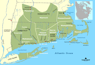
The Niantic were a tribe of Algonquian-speaking American Indians who lived in the area of Connecticut and Rhode Island during the early colonial period. They were divided into eastern and western groups due to intrusions by the more numerous and powerful Pequots. The Western Niantics were subject to the Pequots and lived just east of the mouth of the Connecticut River, while the Eastern Niantics became very close allies to the Narragansetts.

Scarborough Bluffs

The Scarborough Bluffs, also known as The Bluffs, is an escarpment in the Scarborough district of Toronto, Ontario, Canada. There are nine parks along the bluffs, with Bluffers Park being the only one with a beach. Forming much of the eastern portion of Toronto's waterfront, the Scarborough Bluffs stands above the shoreline of Lake Ontario. At its highest point, the escarpment rises 90 metres (300 ft) above the coastline and spans a length of 15 kilometres (9.3 mi).

Rocky Neck State Park Public recreation area in Connecticut, US

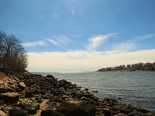
Rocky Neck State Park is a public recreation area on Long Island Sound in the town of East Lyme, Connecticut, United States. The state park's 708 acres (287 ha) include a tidal river, a broad salt marsh, white sand beaches, rocky shores, and a large stone pavilion dating from the 1930s. It is managed by the Connecticut Department of Energy and Environmental Protection.

Sherwood Island State Park

Sherwood Island State Park is a public recreation area on the shore of Long Island Sound in the Greens Farms section of Westport, Connecticut. The state park offers swimming, fishing, and other activities on 238 acres (96 ha) of beach, wetlands, and woodlands. Sherwood Island is numbered as Connecticut's first state park because state purchase of land at the site began in 1914. The park is managed by the Connecticut Department of Energy and Environmental Protection.

Connecticut Route 156 highway in Connecticut

Route 156 is a Connecticut state highway running from East Haddam to Waterford.

Crescent Beach State Park

Crescent Beach State Park is state-operated, public recreation area on the Atlantic Ocean in Cape Elizabeth, Maine, United States. The state park features a mile-long, crescent-shaped beach for swimming and sunbathing, fishing, sea kayaking, and trails for hiking and cross-country skiing.

Thomas Lee House United States historic place

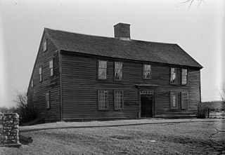
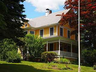
The Thomas Lee House is a historic house at the junction of Giant's Neck Road and Connecticut Route 156 in the Niantic section of East Lyme, Connecticut. Built about 1660, it is one of the oldest wood frame houses in Connecticut. Restored in the early 20th century by Norman Isham, it is now maintained by the East Lyme Historical Society as a museum. It was listed on the National Register of Historic Places in 1970.

The Seaside (Waterford, Connecticut) United States historic place

The Seaside is a historic medical facility at 36 Shore Road in Waterford, Connecticut. It is nationally significant as the first institution designed for heliotropic treatment of children suffering from tuberculosis. Its buildings "comprise an exceptional collection of fully realized and generally well-preserved Tudor Revival-style institutional architecture", which were designed by Cass Gilbert. The property was listed on the National Register of Historic Places in 1995.

Niantic River Bridge

Niantic River Bridge, also known as Amtrak Bascule Bridge No. 116.74, is a railroad bridge carrying Amtrak's Northeast Corridor line across the Niantic River between East Lyme and Waterford, Connecticut. It is a drawbridge with a bascule-type draw span. A new bridge was constructed in 2012 to replace the former span built in 1907. It opened on September 8, 2012. Related construction work finished in June 2013.

Nehantic Trail

The Nehantic Trail is a 13-mile (21 km) Connecticut hiking trail and is one of the Blue-Blazed hiking trails maintained by the Connecticut Forest and Park Association.

Pachaug Trail

The Pachaug Trail is a 28-mile (45 km) Connecticut hiking trail and is one of the Blue-Blazed hiking trails maintained by the Connecticut Forest and Park Association. It is a horseshoe shaped trail.

Bluff Point State Park

Bluff Point State Park is a public recreation area and nature preserve on an undeveloped peninsula located between the Poquonnock River and Mumford Cove on Long Island Sound in the town of Groton, Connecticut. The state park's 806 acres (326 ha) encompass a barrier beach, steep cliffs, forested sections, and tidal wetlands; 778 acres (315 ha) are designated as a coastal reserve. Recreational opportunities include hiking, mountain biking, boating, saltwater fishing, and shell fishing. The park is managed by the Connecticut Department of Energy and Environmental Protection.

Becket Hill State Park Reserve

Becket Hill State Park Reserve is a public recreation area lying adjacent to Nehantic State Forest in the town of Lyme, Connecticut. The state park is as an undeveloped, walk-in park totaling 260 acres (110 ha) with no officially listed activities. It is managed by the Connecticut Department of Energy and Environmental Protection.

Nehantic State Forest

Nehantic State Forest is a publicly owned forest and recreation area occupying two parcels, one in the town of Lyme and one in the towns of East Lyme and Salem, in the state of Connecticut. The forest, which totals 5,062 acres (2,049 ha), is the site of regular prescribed burns and timber-harvesting operations. Purchase of the land began in 1926, when it became the first state forest located in New London County. It is managed by the Connecticut Department of Energy and Environmental Protection.

New London and East Lyme Street Railway

The New London and East Lyme Street Railway was a streetcar line that operated in southeastern Connecticut. Its main line ran from New London to Niantic with a later extension to Crescent Beach and a branch to Old Saybrook. The main portion of the line opened on October 5, 1905. The line was extended to Crescent Beach in 1912. In 1913, it was acquired by the Shore Line Electric Railway and extended to Old Lyme.

Nayantaquit Trail

The Nayantaquit Trail is a 7-mile (11 km) Blue-Blazed hiking trail system in Lyme Connecticut and is entirely in the Nehantic State Forest western block. Parking for the trail can be found at several locations on Keeny Road inside the state forest.

References

  1. Connecticut Geology: The Grain of the land Long Island Sound Resources. Retrieved 2011-01-08
  2. About East Lyme. The Smith-Harris House Commission. Retrieved 2011-01-08.
  3. Chain, Elizabeth. Capt. Thomas Bull. Genealogy.com Posted 2002-02-06. Retrieved 2011-01-08.
  4. McCook's Point Park to Cini Park. Point Park to Cini Park East Lyme Historical Society. Retrieved 2011-01-08.
  5. Brief Descriptions of Connecticut State Agencies. . Connecticut State Library. Revised 2008-08. Retrieved 2011-01-08.
  6. Report of the State Tuberculosis Commission For the Period Beginning October 1, 1918 to June 30, 1920 Internet Archive, uploaded by the University of Toronto on 2008-09-30.
  7. Report of the State Tuberculosis Commission For the Period Beginning July 1, 1920 to June 30, 1922 Internet Archive, uploaded by the University of Toronto on 2008-09-30
  8. Report of the State Tuberculosis Commission For the Period Beginning July 1, 1924 to June 30, 1926 Internet Archive, uploaded by the University of Toronto on 2008-09-30
  9. Chendali, Olive Tubbs. Stories of East Lyme. (East Lyme: East Lyme Public Library) Page 171
  10. Chendali, Olive Tubbs. Stories of East Lyme. (East Lyme: East Lyme Public Library) Pages 172