Granby, Connecticut

Last updated

Granby, Connecticut
Town of Granby
Soldiers' Monument for American Civil War in Granby, Connecticut.jpg
Civil War Soldiers' Monument in the town center
Seal of granby ct.gif
Granby CT lg.PNG
Capitol Region incorporated and unincorporated areas Granby highlighted.svg
Granby, Connecticut
Granby, Connecticut
Granby, Connecticut
Coordinates: 41°57′44″N72°50′22″W / 41.96222°N 72.83944°W / 41.96222; -72.83944
CountryFlag of the United States.svg  United States
U.S. state Flag of Connecticut.svg  Connecticut
County Hartford
Region Capitol Region
Settled1723
Incorporated1786
VillagesGranby (Salmon Brook)
Five Points
Goodrichville
Hungary
Mechanicsville
North Granby
Pegville
West Granby
Government
  Type Board of selectmen-town manager
   First Selectman Barry Scott Kuhnly (R)
  SelectmenMark C. Neumann (R)
Edward E. Ohannessian (R)
Sally S. King (D)
James Lofink(D)
   Town manager John D. Ward
Area
  Total40.8 sq mi (105.7 km2)
  Land40.7 sq mi (105.4 km2)
  Water0.2 sq mi (0.4 km2)
Elevation
550 ft (167 m)
Population
 (2020)
  Total10,903
  Density270/sq mi (100/km2)
Time zone UTC-5 (Eastern)
  Summer (DST) UTC-4 (Eastern)
ZIP Codes
06035, 06060, 06090
Area code(s) 860/959
FIPS code 09-32640
GNIS feature ID0213434
Major highways US 202.svg
Website www.granby-ct.gov

Granby is a town in northern Hartford County, Connecticut, United States. The town is part of the Capitol Planning Region. The population was 10,903 at the 2020 census. [1] The town center is defined as a census-designated place known as Salmon Brook. Other areas in town include North Granby and West Granby. Granby is a rural town, located in the foothills of the Litchfield Hills of the Berkshires, besides the suburban natured center, the outskirts of town are filled with dense woods and rolling hills and mountains. From the 1890s to the 1920s many immigrants from Sweden came to reside in the town.

Contents

History

Granby was founded by people who lived in Simsbury and settled as early as 1723. Granby was part of Simsbury until 1786, when it became independent. [2] The name is from Granby, Massachusetts in return, where it was named in honor of John Manners, Marquess of Granby.

Part of Southwick, Massachusetts, known as "the Notch" seceded from Massachusetts in 1774, just before the outbreak of the American Revolutionary War. This territory became part of Granby when it seceded from Simsbury, but was returned to Southwick as part of an 1803–1804 border dispute compromise. (See History of Massachusetts.)

Daniel Hayes gravestone Daniel Hayes Gravestone.JPG
Daniel Hayes gravestone

In 1707, Daniel Hayes (born c.1685 – died 1756), then aged twenty-two, was captured and kidnapped by a hostile indigenous tribe and carried off to Canada. The capture was witnessed, and a rescue party raised, but the group did not catch up with the captors. He was tied up each night, and bound to saplings. It took thirty days to reach Canada, at which point Hayes was forced to run the gauntlet. Near the end of the gauntlet, he hid in a wigwam to avoid an attempted blow by a club. The woman in the wigwam declared that the house was sacred, and having lost a husband and son to a war, adopted Hayes as her son. He remained for several years, attending to the woman. Eventually, he was sold to a Frenchman, who learned that Hayes had skill as a weaver, so put him to work in that business. Hayes managed to earn enough to buy his freedom after two years. He then returned to Simsbury, settled down on a farm and married. He became prominent, both in civil affairs as well as the church at Salmon Brook (now Granby). [3]

The first unauthorized coins minted in the American colonies, and the first in Connecticut, were struck by Dr. Samuel Higley in 1737 from copper mined from his own mine. The coins, including the Trader's Currency Token of the Colony of Connecticut were minted in North Simsbury, now called Granby. [4] These coins were made of pure copper, which is very soft. Consequently, there are very few in existence today. The first coins were inscribed with a value of three pence. Later versions carried the phrase "Value me as you please." [5]

In 1858, the eastern part of the town broke off and formed to become East Granby, the town is one of the newly established town in the state.

In 2009 Connecticut Magazine ranked Granby the #3 overall Connecticut small town (population 10,000–15,000) to live in, and #1 small town in Hartford County. [6]

The town seal depicts the Dewey-Granby Oak, a large white oak estimated to be 450–500 years old, thought to be one of the oldest trees in New England. [7]

"Dewey Oak" in Granby Dewey Oak Tree - White Oak, Granby, CT - October 17, 2010.jpg
"Dewey Oak" in Granby

Geography

According to the United States Census Bureau, the town has a total area of 40.8 square miles (105.7 km2), of which 40.7 square miles (105.4 km2) is land and 0.15 square miles (0.4 km2), or 0.33%, is water. [8] The town center (Salmon Brook CDP) has a total area of 3.0 square miles (7.8 km2), all land. According to Google Earth, the highest point in Granby is 1,153 feet (351 m) in West Granby at 41°55'57.81" N 72°53'17.18" W. The town is covered in dense woodlands containing animals such as the black bear, eastern moose, and white-tailed deer. Granby is warm and often humid in summer, with occasional thunderstorms, while winter can have heavy snow and cold temperatures. Snow and cold temperatures are not uncommon in early spring and late fall due to the town's location in the Berkshires.

Demographics

Historical population
CensusPop.Note
1820 3,012
1850 2,498
1860 1,720−31.1%
1870 1,517−11.8%
1880 1,340−11.7%
1890 1,251−6.6%
1900 1,2993.8%
1910 1,3836.5%
1920 1,342−3.0%
1930 1,3883.4%
1940 1,54411.2%
1950 2,69374.4%
1960 4,96884.5%
1970 6,15023.8%
1980 7,95629.4%
1990 9,36917.8%
2000 10,34710.4%
2010 11,2829.0%
2020 10,903−3.4%
U.S. Decennial Census [9]

As of the census [10] of 2000, there were 10,347 people, 3,781 households, and 2,994 families residing in the town. The population density was 254.3 inhabitants per square mile (98.2/km2). There were 3,887 housing units at an average density of 95.5 per square mile (36.9/km2). The racial makeup of the town was 97.54% White, 0.61% African American, 0.23% Native American, 0.74% Asian, 0.02% Pacific Islander, 0.23% from other races, and 0.63% from two or more races. Hispanic or Latino of any race were 1.30% of the population.

There were 3,781 households, out of which 39.5% had children under the age of 18 living with them, 71.1% were married couples living together, 5.9% had a female householder with no husband present, and 20.8% were non-families. 16.5% of all households were made up of individuals, and 6.8% had someone living alone who was 65 years of age or older. The average household size was 2.71 and the average family size was 3.06.

In the town, the population was spread out, with 27.3% under the age of 18, 3.7% from 18 to 24, 30.1% from 25 to 44, 27.8% from 45 to 64, and 11.0% who were 65 years of age or older. The median age was 40 years. For every 100 females, there were 98.7 males. For every 100 females age 18 and over, there were 95.1 males.

The median income for a household in the town was $81,151, and the median income for a family was $90,057. Males had a median income of $63,093 versus $42,203 for females. The per capita income for the town was $33,863. About 1.5% of families and 3.1% of the population were below the poverty line, including 3.6% of those under age 18 and 3.2% of those age 65 or over.

Government and politics

Once a Republican stronghold, Granby has become friendlier to Democrats in recent presidential elections. [11] Granby voters flipped from supporting Republican Mitt Romney in 2012 to Democrat Hillary Clinton in 2016. [12] [13] This mirrored a national trend of suburban voters shifting from Donald Trump. In 2020, Democrat Joe Biden won Granby by more than 10 percentage points. [14]

Granby town vote
by party in presidential elections [15]
Year Democratic Republican Third Parties
2020 54.68%4,02942.97% 3,1662.35% 173
2016 47.84%3,11445.58% 2,9676.58% 428
2012 48.28% 3,07950.50%3,2211.22% 78
2008 53.23%3,45645.39% 2,9471.37% 89
2004 48.25% 3,01549.74%3,1082.02% 126
2000 45.73% 2,57648.80%2,7495.47% 308
1996 42.56% 2,19644.22%2,28213.22% 682
1992 35.74% 1,99839.03%2,18225.22% 1,410
1988 38.31% 1,88260.68%2,9811.02% 50
1984 28.19% 1,24771.47%3,1610.34% 15
1980 28.42% 1,19652.58%2,21319.01% 800
1976 35.60% 1,25363.86%2,2480.54% 19
1972 32.36% 1,04466.68%2,1510.96% 31
1968 35.82% 95459.90%1,5954.28% 114
1964 55.16%1,36844.84% 1,1120.00% 0
1960 34.88%85065.12% 1,5870.00% 0
1956 23.05% 44676.95%1,4890.00% 0
Voter Registration and Party Enrollment as of November 1, 2022 [16]
PartyActive VotersInactive VotersTotal VotersPercentage
Republican 2,4401892,62929.20%
Democratic 2,4731832,65629.50%
Unaffiliated 3,2033433,54639.39%
Minor parties151191701.88%
Total8,2677349,001100%

Education

Granby's public school system consists of one primary school, one intermediate school, one middle school, and one high school.

Economy

Top employers

Top employers in Granby according to the town's 2023 Comprehensive Annual Financial Report [17]

#Employer# of Employees
1Town of Granby300-375
2Meadowbrook of Granby100-249
3Imperial Nursery/Monrovia100-249
4Stop and Shop100-249
5Geissler's Supermarket100-249
6Keller Williams Classic Reality100-249
7Salmon Brook Vet Hospital50-99
8State Line Energy50-99
9High Meadow Day Camp50-99
10Farmington Valley YMCA50-99

National Register of Historic Places

Frederick H. Cossitt Library Frederick H. Cossitt Library.JPG
Frederick H. Cossitt Library

Notable people

Notes

  1. "Census - Geography Profile: Granby town, Hartford County, Connecticut". United States Census Bureau . Retrieved December 16, 2021.
  2. "Town of Southwick, Massachusetts". Archived from the original on August 5, 2007. Retrieved October 14, 2007.
  3. Phelps 1845, pp. 37–44.
  4. Federal Writers' Project (1938). Connecticut: A Guide to Its Roads, Lore and People. US History Publishers. p. 58. ISBN   978-1-60354-007-0 . Retrieved September 23, 2010.
  5. American Numismatic Society (1897). Proceedings of the American Numismatic and Archeological Society. p. 16. Retrieved October 20, 2010.
  6. "Rating the Towns 2009: Cities 10,000-15,000". Connecticut Magazine. November 1, 2009. Retrieved April 8, 2022.
  7. "The Ancient Oak of Granby". February 25, 2011.
  8. "Geographic Identifiers: 2010 Demographic Profile Data (G001): Granby town, Hartford County, Connecticut". U.S. Census Bureau, American Factfinder. Archived from the original on February 12, 2020. Retrieved November 26, 2012.
  9. "Census of Population and Housing". Census.gov. Retrieved June 4, 2015.
  10. "U.S. Census website". United States Census Bureau . Retrieved January 31, 2008.
  11. "General Elections Statement of Vote 1922".
  12. Statement of Vote ct.gov
  13. Statement of Vote ct.gov
  14. Statement of Vote ct.gov
  15. "General Election Statements of Vote, 1922 – Current". CT Secretary of State. Retrieved December 16, 2021.
  16. "Registration and Party Enrollment Statistics as of November 1, 2022" (PDF). Connecticut Secretary of State. Archived from the original (PDF) on October 23, 2023. Retrieved October 22, 2023.
  17. "Town of Granby Comprehensive Annual Financial Report For the Fiscal Year Ended June 30, 2023". Town of Granby. Retrieved April 7, 2024.

Related Research Articles

<span class="mw-page-title-main">Hampshire County, Massachusetts</span> County in Massachusetts, United States

Hampshire County is a historical and judicial county located in the U.S. state of Massachusetts. As of the 2020 census, the population was 162,308. Its most populous municipality is Amherst, its largest town in terms of landmass is Belchertown, and its traditional county seat is Northampton. The county is named after the county Hampshire, in England. Hampshire County is part of the Springfield, MA Metropolitan Statistical Area. Together with Hampden County, Hampshire County municipalities belong to the Pioneer Valley Planning Commission.

<span class="mw-page-title-main">Hartford County, Connecticut</span> County in Connecticut, United States

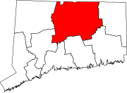
Hartford County is a county located in the north central part of the U.S. state of Connecticut. According to the 2020 census, the population was 899,498, making it the second-most populous county in Connecticut. Hartford County contains the city of Hartford, the state capital of Connecticut and the county's most populous city, with 121,054 residents at the 2020 census. Hartford County is included in the Hartford-East Hartford-Middletown metropolitan statistical area.

<span class="mw-page-title-main">Bloomfield, Connecticut</span> Town in Connecticut, United States

Bloomfield is a suburb of Hartford in the Capitol Planning Region, Connecticut, United States. The town's population was 21,535 at the 2020 census. Bloomfield is best known as the headquarters of healthcare services company Cigna.

<span class="mw-page-title-main">Blue Hills, Connecticut</span> Place in Connecticut, United States

Blue Hills is a community in Hartford County, Connecticut, encompassing the northwest corner of the city of Hartford and the southeast corner of the town of Bloomfield. The Bloomfield portion is listed by the U.S. Census Bureau as a census-designated place (CDP), with a population of 2,762 at the 2020 census.

<span class="mw-page-title-main">Canton, Connecticut</span> Town in Connecticut, United States

Canton is a town, incorporated in 1806, located in the Farmington Valley section of the Capitol Planning Region, Connecticut, United States. The population was 10,124 as of the 2020 census. It is bordered by Granby on the north, Simsbury on the east, Avon and Burlington on the south, New Hartford on the west, and Barkhamsted on the northwest. Running through it is the Farmington River. The town includes the villages of North Canton, Canton Center, Canton, and Collinsville. In September 2007, Collinsville was ranked in Budget Travel magazine as one of the "Ten Coolest Small Towns In America".

<span class="mw-page-title-main">East Granby, Connecticut</span> Town in Connecticut, United States

East Granby is a town in the Capitol Planning Region, Connecticut, United States. The population was 5,214 at the 2020 census.

<span class="mw-page-title-main">Hartland, Connecticut</span> Town in Connecticut, United States

Hartland is a town in Hartford County, Connecticut, United States. The population was 1,901 at the 2020 census. The rural town is part of the Northwest Hills Planning Region and forms the northwest border of Hartford County. Currently, the town consists of two unincorporated areas, East and West Hartland, entirely separated by the northern portion of the Barkhamsted Reservoir. A third area, Hartland Hollow, was flooded when the reservoir was completed in 1940.

<span class="mw-page-title-main">North Granby, Connecticut</span> Census-designated place in Connecticut, United States

North Granby is a village and census-designated place (CDP) in Hartford County, Connecticut, United States. It is part of the town of Granby. The population was 1,944 at the 2010 census.

<span class="mw-page-title-main">Simsbury, Connecticut</span> Town in Connecticut, United States

Simsbury is a town in Hartford County, Connecticut, United States, incorporated as Connecticut's 21st town in May 1670. The town is part of the Capitol Planning Region. The population was 24,517 in the 2020 census.

<span class="mw-page-title-main">Tariffville, Connecticut</span> Census-designated place in Connecticut, United States

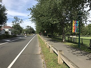
Tariffville is a neighborhood and census-designated place (CDP) in the town of Simsbury in Hartford County, Connecticut, United States. The population was 1,324 at the 2010 census. It is a popular location for whitewater paddlers who use the Farmington River.

<span class="mw-page-title-main">Weatogue, Connecticut</span> Census-designated place in Connecticut, United States

Weatogue is a village and census-designated place in Simsbury, Hartford County, Connecticut. The population was 2,776 at the 2010 census.

<span class="mw-page-title-main">West Simsbury, Connecticut</span> Census-designated place in Connecticut, United States

West Simsbury is a census-designated place (CDP) and section of the town of Simsbury in Hartford County, Connecticut, United States. The population of the CDP was 2,447 at the 2010 census.

<span class="mw-page-title-main">Barkhamsted, Connecticut</span> Town in Connecticut, United States

Barkhamsted is a town in Litchfield County, Connecticut, United States. It contains seven villages: West Hill, Mallory, Barkhamsted Center, Center Hill, Washington Hill, Pleasant Valley, and Riverton. The population was 3,647 at the 2020 census, down from 3,799 at the 2010 census. The town is part of the Northwest Hills Planning Region. Barkhamsted was first incorporated in 1779, and named after Berkhamsted, Hertfordshire, England.

<span class="mw-page-title-main">Colebrook, Connecticut</span> Town in Connecticut, United States

Colebrook is a town in Litchfield County, Connecticut, United States. The population was 1,361 at the 2020 census. The town is part of the Northwest Hills Planning Region. Colebrook was named after Colebrooke in the English county of Devon; the reason is now unknown.

<span class="mw-page-title-main">Woodbury, Connecticut</span> Town in Connecticut, United States

Woodbury is a town in Litchfield County, Connecticut, United States. The town is part of the Naugatuck Valley Planning Region. The population was 9,723 at the 2020 census. The town center, comprising the adjacent villages of Woodbury and North Woodbury, is designated by the U.S. Census Bureau as the Woodbury Center census-designated place (CDP). Woodbury was founded in 1673.

<span class="mw-page-title-main">Somers, Connecticut</span> Town in Connecticut, United States

Somers is a town in Tolland County, Connecticut. The town is part of the Capitol Planning Region. The population was 10,255 at the 2020 census. The town center is listed by the U.S. Census Bureau as a census-designated place (CDP). In 2007, Money Magazine listed Somers 53rd on its "100 Best Places to Live", based on "economic opportunity, good schools, safe streets, things to do and a real sense of community."

<span class="mw-page-title-main">Southwick, Massachusetts</span> Town in Massachusetts, United States

Southwick is a town in Hampden County, Massachusetts, United States. The population was 9,232 at the 2020 census, down from 9,502 at the 2010 census. It is part of the Springfield, Massachusetts Metropolitan Statistical Area.

<span class="mw-page-title-main">Simsbury Center, Connecticut</span> Census-designated place in Connecticut, United States

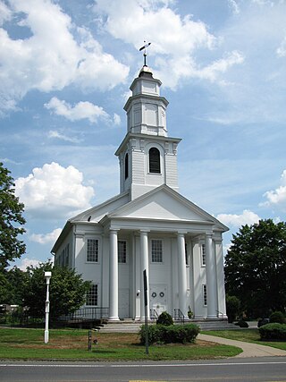
Simsbury Center is a census-designated place (CDP) that consists of the central settlement, and the neighborhoods immediately surrounding it, in the town of Simsbury, Connecticut, in the United States. As of the 2010 census, the CDP had a population of 5,836. The core area of the CDP is listed as the Simsbury Center Historic District on the National Register of Historic Places.

<span class="mw-page-title-main">Granby, Massachusetts</span> Town in Massachusetts, United States

Granby is a town in Hampshire County, Massachusetts, United States. The population was 6,110 at the 2020 census. It is part of the Springfield, Massachusetts Metropolitan Statistical Area. The census-designated place of Granby corresponds to the main village of Granby in the center of the town.

<span class="mw-page-title-main">Salmon Brook, Connecticut</span> Census-designated place in Connecticut, United States

Salmon Brook is the name of a census-designated place (CDP) corresponding to the village of Granby, the primary settlement of the town of Granby, Connecticut, in Hartford County. The population of the CDP was 2,324 as of the 2010 census.

References