Collinsville, Connecticut

Last updated

Collinsville Historic District
USA Connecticut location map.svg
Red pog.svg
Usa edcp location map.svg
Red pog.svg
LocationCT 179, Collinsville, Connecticut
Coordinates 41°48′44″N72°55′22″W / 41.81222°N 72.92278°W / 41.81222; -72.92278
ArchitectCollins Co.
Architectural styleGreek Revival, Italianate, Romanesque
NRHP reference No. 76001994 [1]
Added to NRHPJune 23, 1976

Collinsville is a village and census-designated place (CDP) in the town of Canton, Hartford County, Connecticut, United States. The population was 3,746 at the 2010 census. [2] The central portion of the village is a historic district listed on the National Register of Historic Places.

Contents

It was built around the Collins Company Axe Factory, a manufacturer of edge tools, such as axes, machetes, picks and knives. [3] Collins machetes were the brand of choice in South America. Collins tools were used almost exclusively for the construction of the Trans-Siberian Railway, and axes and picks made their way across the country to be used in the California Gold Rush. Admiral Peary carried Collins tools to the North Pole.[ citation needed ]

Typical of New England mills, the Collins Company axe factory was sited on a river (the Farmington), and their production was powered by utilizing the water's strength to turn turbines and power machines. The numerous old buildings ramble along the riverbanks intertwined by an intricate maze of sluices that run throughout the site. The company closed its doors in 1966, but the factory buildings stayed standing and are now rented out to local businesses. The ambiance of Main Street reflects period architecture with ornate details from the start of the 20th century.[ citation needed ]

History

According to historian Diana Muir, writing in Reflections in Bullough's Pond , it was in Collinsville that Elisha Root invented the important industrial technique of die casting. Root was employed by Samuel W. Collins, whose Collins and Company was the largest manufacturer of axes in the nineteenth century. Other famous historical residents of Collinsville included George Washington Flint and William E. Simonds.

Collinsville hosts an annual Halloween Parade through the historic town. The parade is held on the last Saturday of October at 7 p.m. Children's activities begin at 6 p.m. [4]

Collinsville was voted one of the "Top 10 Coolest Small Towns in America" in the September 2007 issue of Arthur Frommer's Budget Travel magazine. [5]

Geography

According to the United States Census Bureau, the CDP has a total area of 3.6 square miles (9.2 km2), of which 3.1 square miles (8.1 km2) is land and 0.42 square miles (1.1 km2), or 11.79%, is water. [2]

Demographics

As of the census [6] of 2000, there were 2,686 people, 1,080 households, and 723 families residing in the CDP. The population density was 871.8 inhabitants per square mile (336.6/km2). There were 1,128 housing units at an average density of 366.1 per square mile (141.4/km2). The racial makeup of the CDP was 97.54% White, 0.56% African American, 0.07% Native American, 0.48% Asian, 0.30% from other races, and 1.04% from two or more races. Hispanic or Latino of any race were 1.60% of the population.

There were 1,080 households, out of which 32.8% had children under the age of 18 living with them, 51.9% were married couples living together, 11.3% had a female householder with no husband present, and 33.0% were non-families. 26.5% of all households were made up of individuals, and 5.2% had someone living alone who was 65 years of age or older. The average household size was 2.40 and the average family size was 2.91.

In the CDP, the population was spread out, with 24.3% under the age of 18, 5.0% from 18 to 24, 31.9% from 25 to 44, 26.2% from 45 to 64, and 12.6% who were 65 years of age or older. The median age was 39 years. For every 100 females, there were 91.4 males. For every 100 females age 18 and over, there were 87.1 males.

The median income for a household in the CDP was $60,690, and the median income for a family was $66,550. Males had a median income of $44,414 versus $37,679 for females. The per capita income for the CDP was $29,050. About 1.4% of families and 1.5% of the population were below the poverty line, including 2.3% of those under age 18 and none of those age 65 or over.

Sites

Some of the Collins Company factory buildings in Collinsville on the Farmington River, viewed from Connecticut Route 179 Collins-Mill-in-Collinsville-CT.jpg
Some of the Collins Company factory buildings in Collinsville on the Farmington River, viewed from Connecticut Route 179

Collinsville is located directly on the Farmington River, and is a common place for people to walk and bike to, due to its convenient location along the Rails to Trails path. There are many cultural attractions in this town center, including LaSalle Restaurant, where customers are allowed to leave before paying, and return when they have finished eating, to pay.[ citation needed ] Frequently on Sundays and other occasions, there are live music demonstrations in the parking lot outside.

The Canton Historical Museum is located in a former Collins Company factory building built in 1865. Originally constructed to finish and assemble agricultural plows, the building was converted in 1924 to a recreational facility for its employees. Fred Widen, a pattern maker for the company, used a portion of the building for his large collection of Collins memorabilia. Today, the Canton Historical Society owns the 14,000+ sq. ft. building and has a large assortment of Collins Tools, as well as many Victorian items, a general store, farm/agricultural equipment, children's toys, looms, and a Bridal Parlor featuring wedding dresses worn by Canton residents from the late 1800s. Also of interest, are several Regina music boxes, a large pump fire engine, used by the Collins Company, an Edison phonograph and Edison fans. Upstairs, the Farmington Valley Railroad Society operates a railroad diorama of the village of Collinsville around the start of the 20th century.

A research and genealogical library containing thousands of documents and photographs related to Canton and Collinsville history is also located upstairs, including black and white photos of the 1955 flood. Information about local cemeteries in Canton and Collinsville are available in the library. The museum covers three floors with limited handicap accessibility, but plans are underway to make the building more accessible in the future.

In the 19th century, a Collinsville butcher feuded with his neighbor. [7] To spite his neighbor, the butcher built between their adjoining houses a narrow, two-story structure with windows covered by Venetian blinds. [7] The wooden building located between 23 and 25 River Street was the width of a standard stairway and allowed the butcher to block the sun to the neighbor's home and block the neighbor's view of the butcher's property at will. [7] [8] The butcher's son got along with the family next door and eventually tore down the Collinsville Spite House. [7]

See also

Related Research Articles

<span class="mw-page-title-main">Hartford County, Connecticut</span> County in Connecticut, United States

Hartford County is a county located in the north central part of the U.S. state of Connecticut. According to the 2020 census, the population was 899,498, making it the second-most populous county in Connecticut. Hartford County contains the city of Hartford, the state capital of Connecticut and the county's most populous city, with 121,054 residents at the 2020 census. Hartford County is included in the Hartford-East Hartford-Middletown metropolitan statistical area.

<span class="mw-page-title-main">Canton, Connecticut</span> Town in Connecticut, United States

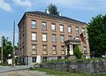
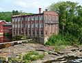
Canton is a town, incorporated in 1806, located in the Farmington Valley section of the Capitol Planning Region, Connecticut, United States. The population was 10,124 as of the 2020 census. It is bordered by Granby on the north, Simsbury on the east, Avon and Burlington on the south, New Hartford on the west, and Barkhamsted on the northwest. Running through it is the Farmington River. The town includes the villages of North Canton, Canton Center, Canton, and Collinsville. In September 2007, Collinsville was ranked in Budget Travel magazine as one of the "Ten Coolest Small Towns In America".

<span class="mw-page-title-main">Farmington, Connecticut</span> Town in Connecticut, United States

Farmington is a town in Hartford County in the Farmington Valley area of central Connecticut in the United States. The town is part of the Capitol Planning Region. The population was 26,712 at the 2020 census. It sits 10 miles west of Hartford at the hub of major I-84 interchanges, 20 miles south of Bradley International Airport and two hours by car from New York City and Boston. It has been home to the world headquarters of several large corporations including Otis Elevator Company, United Technologies, and Carvel. The northwestern section of Farmington is a suburban neighborhood called Unionville.

<span class="mw-page-title-main">Kensington, Connecticut</span> Census-designated place in Connecticut, United States

Kensington is a census-designated place (CDP) and section of the town of Berlin in Hartford County, Connecticut, United States. The Berlin town offices are located in Kensington. The population was 8,459 at the 2010 census.

<span class="mw-page-title-main">Sherwood Manor, Connecticut</span> Census-designated place in Connecticut, United States

Sherwood Manor is a census-designated place (CDP) within the town of Enfield in Hartford County, Connecticut, United States. The population was 5,410 at the 2010 census.

<span class="mw-page-title-main">Simsbury, Connecticut</span> Town in Connecticut, United States

Simsbury is a town in Hartford County, Connecticut, United States, incorporated as Connecticut's 21st town in May 1670. The town is part of the Capitol Planning Region. The population was 24,517 in the 2020 census.

<span class="mw-page-title-main">Southington, Connecticut</span> Town in Connecticut, United States

Southington is a town in Hartford County, Connecticut, United States. The town is part of the Capitol Planning Region. As of the 2020 United States Census, it had a population of 43,501. Southington contains the villages of Marion, Milldale, and Plantsville.

<span class="mw-page-title-main">Tariffville, Connecticut</span> Census-designated place in Connecticut, United States

Tariffville is a neighborhood and census-designated place (CDP) in the town of Simsbury in Hartford County, Connecticut, United States. The population was 1,324 at the 2010 census. It is a popular location for whitewater paddlers who use the Farmington River.

<span class="mw-page-title-main">Weatogue, Connecticut</span> Census-designated place in Connecticut, United States

Weatogue is a village and census-designated place in Simsbury, Hartford County, Connecticut, United States. The population was 2,776 at the 2010 census.

<span class="mw-page-title-main">West Simsbury, Connecticut</span> Census-designated place in Connecticut, United States

West Simsbury is a census-designated place (CDP) and section of the town of Simsbury in Hartford County, Connecticut, United States. The population of the CDP was 2,447 at the 2010 census.

<span class="mw-page-title-main">New Hartford, Connecticut</span> Town in Connecticut, United States

New Hartford is a town in Litchfield County, Connecticut, United States. The population was 6,658 at the 2020 census. The town is part of the Northwest Hills Planning Region. The town center is defined by the U.S. Census Bureau as the New Hartford Center census-designated place (CDP). The town is mainly a rural community consisting of farms, homes, and parks. Brodie Park and Ski Sundown are located in New Hartford.

<span class="mw-page-title-main">Terryville, Connecticut</span> Census-designated place in Plymouth, Connecticut, US

Terryville is a census-designated place (CDP) in Litchfield County, Connecticut, United States, and is the largest village within the town of Plymouth. In the 2010 census, Terryville had a population of 5,387, out of 12,243 in the entire town of Plymouth. The village is named for Eli Terry Jr., the son of the well-known clockmaker Eli Terry Sr. Terryville is also home to the Lock Museum of America. There is a water wheel located in downtown Terryville that is dedicated to the son of Eli Terry Sr.

<span class="mw-page-title-main">Simsbury Center, Connecticut</span> Census-designated place in Connecticut, United States

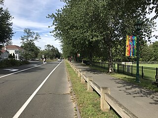
Simsbury Center is a census-designated place (CDP) that consists of the central settlement, and the neighborhoods immediately surrounding it, in the town of Simsbury, Connecticut, United States. As of the 2010 census, the CDP had a population of 5,836. The core area of the CDP is listed as the Simsbury Center Historic District on the National Register of Historic Places.

<span class="mw-page-title-main">Wilder, Vermont</span> Census-designated place in Vermont, United States

Wilder is an unincorporated village and census-designated place (CDP) within the town of Hartford in Windsor County, Vermont, United States. It is the location of the Wilder Dam on the Connecticut River. The population of the CDP was 1,690 at the 2010 census. The village center is an early example of a planned mill community, and was listed on the National Register of Historic Places as the Wilder Village Historic District in 1999.

<span class="mw-page-title-main">Durham, Connecticut</span> Town in Connecticut, United States

Durham is a town in Middlesex County, Connecticut, United States. Durham is a former farming village on the Coginchaug River in central Connecticut. The town is part of the Lower Connecticut River Valley Planning Region. The population was 7,152 at the 2020 census. Every autumn, the town hosts the Durham Fair, the largest volunteer agricultural fair in New England.

<span class="mw-page-title-main">Farmington River</span> River in the United States of America

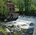
The Farmington River is a river, 46.7 miles (75.2 km) in length along its main stem, located in northwest Connecticut with major tributaries extending into southwest Massachusetts. The longest route of the river, from the origin of its West Branch, is 80.4 miles (129.4 km) long, making it the Connecticut River's longest tributary by 2.3 miles (3.7 km) over the major river directly to its north, the Westfield River. The Farmington River's watershed covers 609 square miles (1,580 km2). Historically, the river played an important role in small-scale manufacturing in towns along its course, but it is now mainly used for recreation and drinking water.

<span class="mw-page-title-main">Suffield Depot, Connecticut</span> Census-designated place in Connecticut, United States

Suffield Depot is the name of a census-designated place (CDP) corresponding to the village of Suffield, the primary settlement of the town of Suffield, Connecticut, United States, in Hartford County. The population of the CDP was 1,325 as of the 2010 census.

<span class="mw-page-title-main">Canton Valley, Connecticut</span> Census-designated place in Connecticut, United States

Canton Valley is a village and census-designated place (CDP) in the town of Canton in Hartford County, Connecticut, United States. The population was 1,580 at the 2010 census. As of the 2017 census the population was 1,489.

<span class="mw-page-title-main">New Hartford Center, Connecticut</span> Census-designated place in Connecticut, United States

New Hartford Center is a census-designated place (CDP) in Litchfield County, Connecticut, United States. It comprises the village of New Hartford, the adjacent Pine Meadow Historic District, and some surrounding forest land, all within the town of New Hartford. As of the 2010 census, the population of New Hartford Center was 1,385, out of 6,970 in the entire town of New Hartford.

<span class="mw-page-title-main">Manchester (CDP), Connecticut</span> Census-designated place in Connecticut, United States

Manchester is a census-designated place (CDP) in Hartford County, Connecticut, United States, comprising the urban center of the town of Manchester. As of the 2010 census, the population of the CDP was 30,577, out of 58,241 in the entire town.

References

  1. "National Register Information System". National Register of Historic Places . National Park Service. March 13, 2009.
  2. 1 2 "Geographic Identifiers: 2010 Demographic Profile Data (G001): Collinsville CDP, Connecticut". U.S. Census Bureau, American Factfinder. Archived from the original on February 12, 2020. Retrieved November 29, 2012.
  3. Federal Writers' Project. Connecticut: A Guide to Its Roads, Lore and People. US History Publishers. p. 427. ISBN   978-1-60354-007-0 . Retrieved September 23, 2010.
  4. Collinsville Halloween
  5. Budget Travel article
  6. "U.S. Census website". United States Census Bureau . Retrieved January 31, 2008.
  7. 1 2 3 4 Hirsh, Linda B. (April 17, 1994) Hartford Courant Walking Tour Puts the Traveler in 19th-Century Collinsville. Section: Town News Extra; Page H1.
  8. Hirsh, Linda B. (April 17, 1994) Hartford Courant The Canton Time Machine; But There Are Some Places That Can Only Be Remembered. Archived November 8, 2012, at the Wayback Machine Section: Town News Extra; page H1.