South Windsor, Connecticut

Last updated

South Windsor, Connecticut
Town of South Windsor
FormerMemorialLibrarySouthWindsorCT.jpg
Former Memorial Library
Seal of South Windsor, Connecticut.svg
S Windsor CT lg.PNG
Capitol Region incorporated and unincorporated areas South Windsor highlighted.svg
South Windsor, Connecticut
Coordinates: 41°49′56″N72°34′11″W / 41.83222°N 72.56972°W / 41.83222; -72.56972
CountryFlag of the United States.svg  United States
U.S. state Flag of Connecticut.svg  Connecticut
County Hartford
Region Capitol Region
Settled1652
IncorporatedSeptember 3, 1845
Government
  Type Council-manager
  South Windsor Town CouncilLiz Pendleton (D), Mayor
Steven King, Jr. (D), Deputy Mayor
Andrew Paterna (D)
Erica Evans (D)
Matt Siracusa (R)
Marek Kozikowski(R)
Cesar Lopez (D)
Philip Koboski(R)
Karen Lydecker (D) [1]
  Town managerMichael Maniscalco
Area
  Total28.7 sq mi (74.3 km2)
  Land28.1 sq mi (72.7 km2)
  Water0.6 sq mi (1.6 km2)
Elevation
72 ft (22 m)
Population
 (2020)
  Total26,918
  Density940/sq mi (360/km2)
Time zone UTC-5 (EST)
  Summer (DST) UTC-4 (EDT)
ZIP Code
06074
Area code(s) 860/959
FIPS code 09-71390
GNIS feature ID0213509
Interstates I-291.svg
U.S. Highways US 5.svg
State Routes Connecticut Highway 30.svg Connecticut Highway 74.svg Connecticut Highway 194.svg
Website www.southwindsor-ct.gov

South Windsor is a town in Hartford County, Connecticut, United States. The town is part of the Capitol Planning Region. The population was 26,918 at the 2020 census. [2]

Contents

History

In 1659, Thomas Burnham (1617–1688) purchased the tract of land now covered by the towns of South Windsor and East Hartford from Tantinomo, chief sachem of the Podunk Indians. [3] Burnham lived on the land and later willed it to his nine children. [4] Beginning in the middle of the 17th century, a few settlers from Windsor began using land on the east bank of the Connecticut River for grazing and farming purposes. By 1700, a number of families had made their homes in the area. In 1768, the residents of the area were allowed to incorporate as the separate town of East Windsor, though the area was informally referred to as East Windsor before this time. At the time, the town included all of what is now the present-day towns of East Windsor, South Windsor, and Ellington. Known for its agriculture and ship building, the town of East Windsor, including South Windsor, supplied more than 200 volunteers during the American Revolution. In 1786, Ellington became an independent town, and South Windsor was incorporated as a separate town in 1845. [5] Tobacco has been a major crop grown in South Windsor since its founding.

(Old) Main Street, located near the Connecticut River and running north to south from the border of East Windsor to that of East Hartford, is the center of the town's historic district. The Wood Memorial Library & Museum and Ellsworth School are located on the street. Minister Timothy Edwards, the namesake of the town's middle school, is buried in a cemetery located on this street. In 1698, Edwards became the first minister for the settlers on the east side of the river, and his church was built on Main Street (in present-day South Windsor). His son, theologian Jonathan Edwards, was born in South Windsor (at the time still part of Windsor). Ulysses S. Grant stayed at home on the street.

The town has become less and less agricultural and rural since 1950. This former farming community has been transformed into a suburban town with industrial and commercial districts. The town's population more than tripled between 1950 and 2000. In the early 1990s, residents mobilized a successful campaign against a proposed nuclear waste dump located near the East Windsor town line.

On the National Register of Historic Places

Geography

According to the United States Census Bureau, the town has a total area of 28.7 square miles (74.3 km2), of which 28.1 square miles (72.7 km2) is land and 0.62 square miles (1.6 km2), or 2.12%, is water. [2]

Climate data for South Windsor, Connecticut
MonthJanFebMarAprMayJunJulAugSepOctNovDecYear
Record high °F (°C)70
(21)
74
(23)
86
(30)
93
(34)
99
(37)
100
(38)
101
(38)
102
(39)
101
(38)
89
(32)
83
(28)
75
(24)
102
(39)
Mean daily maximum °F (°C)36
(2)
39
(4)
48
(9)
60
(16)
70
(21)
79
(26)
84
(29)
82
(28)
75
(24)
63
(17)
52
(11)
41
(5)
61
(16)
Mean daily minimum °F (°C)18
(−8)
22
(−6)
29
(−2)
40
(4)
49
(9)
59
(15)
65
(18)
63
(17)
54
(12)
42
(6)
35
(2)
24
(−4)
42
(5)
Record low °F (°C)−17
(−27)
−24
(−31)
−4
(−20)
11
(−12)
25
(−4)
39
(4)
45
(7)
38
(3)
29
(−2)
18
(−8)
5
(−15)
−12
(−24)
−24
(−31)
Average precipitation inches (mm)3.15
(80)
2.75
(70)
3.57
(91)
3.88
(99)
3.89
(99)
3.99
(101)
4.00
(102)
3.66
(93)
3.48
(88)
4.14
(105)
3.84
(98)
3.35
(85)
43.70
(1,110)
Source: Weather Channel [6]

Demographics

Historical population
CensusPop.Note
1850 1,638
1860 1,7899.2%
1870 1,688−5.6%
1880 1,90212.7%
1890 1,736−8.7%
1900 2,01416.0%
1910 2,25111.8%
1920 2,142−4.8%
1930 2,53518.3%
1940 2,86312.9%
1950 4,06642.0%
1960 9,460132.7%
1970 15,55364.4%
1980 17,19810.6%
1990 22,09028.4%
2000 24,41210.5%
2010 25,7095.3%
2020 26,9184.7%
DECD [7]

As of the census [8] of 2000, there were 24,412 people, 8,905 households, and 6,767 families residing in the town. The population density was 873.1 inhabitants per square mile (337.1/km2). There were 9,071 housing units at an average density of 324.4 per square mile (125.3/km2). The racial makeup of the town was 85.95% White, 2% African American, 0.18% Native American, 3.71% Asian, 0.03% Pacific Islander, 0.66% from other races, and 0.96% from two or more races. Hispanic or Latino of any race were 2.27% of the population.

There were 8,905 households, out of which 38.5% had children under the age of 18 living with them, 65.7% were married couples living together, 7.5% had a female householder with no husband present, and 24.0% were non-families. 19.8% of all households were made up of individuals, and 6.9% had someone living alone who was 65 years of age or older. The average household size was 2.72 and the average family size was 3.16.

In the town, the population was spread out, with 27.4% under the age of 18, 5.0% from 18 to 24, 29.7% from 25 to 44, 26.0% from 45 to 64, and 11.9% who were 65 years of age or older. The median age was 39 years. For every 100 females, there were 93.0 males. For every 100 females age 18 and over, there were 88.7 males.

The median income for a household in the town was $73,990, and the median income for a family was $82,807. Males had a median income of $55,703 versus $38,665 for females. The per capita income for the town was $30,966. About 1.5% of families and 1.8% of the population were below the poverty line, including 0.8% of those under age 18 and 4.6% of those age 65 or over.

Economy

Top employers

Top employers in South Windsor according to the town's 2020 Comprehensive Annual Financial Report [9]

#Employer# of Employees
1Town of South Windsor891
2DST Output650
3Ticket Network441
4May Company389
5Doosan Fuel Cell America, Inc.320
6 Target Corporation 250
7 Stop & Shop 221
8Performance Food Group183
9 Lowe's 170
10Electro-Methods, Inc.155

Education

Children attending the public school systems in South Windsor begin at the elementary school level (Kindergarten through Grade 5) at one of four elementary schools: Pleasant Valley, Orchard Hill, Philip R. Smith, and Eli Terry, with Wapping now used by the local recreation department, instead of previously running as a school. After graduating from elementary school, students then move on to Timothy Edwards Middle School, for grades 6–8. They also have the choice to go to a magnet school, Two Rivers Magnet Middle School in East Hartford. They then finish up their schooling at South Windsor High School. Over 140 students in the 2004, 2005, and 2006 classes have been admitted to the University of Connecticut in Storrs.

Government and politics

South Windsor Town Council
Type
Type
Leadership
Liz Pendleton, Democrat
Steven King Jr., Democrat
Mike Maniscalco
Structure
Seats9
Political groups
Republican Party (3)
Democratic Party (6)
Elections
Last election
November 2, 2021
Meeting place
Council Chambers, 1540 Sullivan Ave.
Website
Official website

Town council

South Windsor is governed by a council-manager form of government. The town manager is appointed by the town council and the leader of the council is designated as the mayor, with a deputy mayor also chosen from amongst the council.

The town council holds its elections every two years, on odd-numbered years. Each party nominates only up to six candidates for the nine town council positions (which are all at-large), and each voter may only vote for up to six candidates from the pool of all candidates nominated by all parties. The top nine vote-getters win seats on the town council; as a result the council always has a 5–4 or 6–3 majority (assuming only two parties are participating), ensuring representation of the minority party.

Voting

Voter Registration and Party Enrollment as of October 26, 2021 [10]
PartyActive VotersInactive VotersTotal VotersPercentage
Democratic 6,2303136,54335.17%
Republican 3,5762323,80820.47%
Unaffiliated 7,4425107,95242.75%
Minor parties280192991.61%
Total17,5281,07418,602100%
Election results from statewide races
YearOfficeResults
2020 President Biden 61.1–37.0%
Congress Larson 63.6–35.1%
2018 Governor Lamont 47.5–44.6%
Senator Murphy 60.1–38.7%
Congress Larson 63.4–35.7%
2016 President Clinton 54.9–40.5%
Senator Blumenthal 63.6–34.4%
Congress Larson 61.7–36.8%
2014 Governor Foley 49.7–48.9%
Congress Larson 62.1–36.7%
2012 President Obama 56.3–42.1%
Senator Murphy 52.8–42.9%
Congress Larson 65.4–27.8%
2010 Governor Foley 50.7–48.0%
Senator Blumenthal 53.0–42.9%
Congress Larson 58.1–38.8%
2008 President Obama 60.0–37.7%
Congress Larson 67.7–24.8%
2006 Governor Rell 63.7–35.3%
Senator Lieberman 48.4–41.8–9.0%
Congress Larson 73.2–23.0%
2004 President Kerry 54.5–44.0%
Senator Dodd 69.6–29.0%
Congress Larson 74.4–25.6%

Notable people

Related Research Articles

<span class="mw-page-title-main">Hartford County, Connecticut</span> County in Connecticut, United States

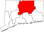
Hartford County is a county located in the north central part of the U.S. state of Connecticut. According to the 2020 census, the population was 899,498, making it the second-most populous county in Connecticut. Hartford County contains the city of Hartford, the state capital of Connecticut and the county's most populous city, with 121,054 residents at the 2020 census. Hartford County is included in the Hartford-East Hartford-Middletown metropolitan statistical area.

<span class="mw-page-title-main">Middlesex County, Connecticut</span> County in Connecticut, United States

Middlesex County is a county in the south central part of the U.S. state of Connecticut. As of the 2020 census, the population was 164,245. The county was created in May 1785 from portions of Hartford County and New London County.

<span class="mw-page-title-main">Bloomfield, Connecticut</span> Town in Connecticut, United States

Bloomfield is a suburb of Hartford in the Capitol Planning Region, Connecticut, United States. The town's population was 21,535 at the 2020 census. Bloomfield is best known as the headquarters of healthcare services company Cigna.

<span class="mw-page-title-main">Broad Brook, Connecticut</span> Census-designated place in Connecticut, United States

Broad Brook is a neighborhood and census-designated place (CDP) in the town of East Windsor, Hartford County, Connecticut, United States. As of the 2010 census, the CDP population was 4,069.

<span class="mw-page-title-main">East Windsor, Connecticut</span> Town in Connecticut, United States

East Windsor is a town in Hartford County, Connecticut, United States. The town is part of the Capitol Planning Region. The population was 11,190 at the 2020 census. The town has five villages: Broad Brook, Melrose, Scantic, Warehouse Point and Windsorville.

<span class="mw-page-title-main">Marlborough, Connecticut</span> Town in Connecticut, United States

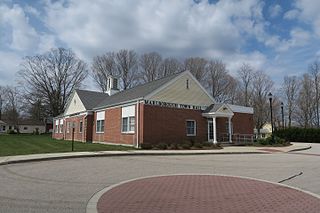
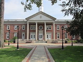
Marlborough is a town in Hartford County, Connecticut, United States. It contains the census-designated place (CDP) of Terramuggus. The town is part of the Capitol Planning Region. The town's population was 6,133 at the 2020 census. Marlborough is a suburban and rural community. The local high school is RHAM High School. In 2013, Marlborough ranked third in Connecticut Magazine's biannual ranking of Connecticut small towns. Educationally, RHAM High School, which serves Marlborough, Hebron, and Andover students, is one of the top-ranked regional high schools in the state on the SAT in 2017, and 11th highest-performing school in the state on the test. The town is home to Elmer Theines-Mary Hall elementary school which serves Pre-K through 6th grade. The school scores above state average on standardized testing and student progress.

<span class="mw-page-title-main">Plainville, Connecticut</span> Town in Connecticut, United States

Plainville is a town in Hartford County, Connecticut, United States. The town is part of the Capitol Planning Region. The population was 17,525 at the 2020 census.

<span class="mw-page-title-main">Rocky Hill, Connecticut</span> Town in Connecticut, United States

Rocky Hill is a town in Hartford County, Connecticut, United States. The town is part of the Capitol Planning Region. The population was 20,845 at the 2020 census. It was originally land of the Wangunks. Europeans began to settle the area of Rocky Hill in 1650, as part of Wethersfield, the neighboring town to the north. In 1722, the area became known as Stepney Parish, until it was independently incorporated in 1843. Rocky Hill’s location on the Connecticut River made it a natural port for Wethersfield and an early center for shipbuilding, agriculture, and trade.

<span class="mw-page-title-main">Windsor, Connecticut</span> Town in Connecticut, United States

Windsor is a town in Hartford County, Connecticut, United States, and was the first English settlement in the state. It lies on the northern border of Connecticut's capital, Hartford. The town is part of the Capitol Planning Region. The population of Windsor was 29,492 at the 2020 census.

<span class="mw-page-title-main">Barkhamsted, Connecticut</span> Town in Connecticut, United States

Barkhamsted is a town in Litchfield County, Connecticut, United States. It contains seven villages: West Hill, Mallory, Barkhamsted Center, Center Hill, Washington Hill, Pleasant Valley, and Riverton. The population was 3,647 at the 2020 census, down from 3,799 at the 2010 census. The town is part of the Northwest Hills Planning Region. Barkhamsted was first incorporated in 1779, and named after Berkhamsted, Hertfordshire, England.

<span class="mw-page-title-main">Bridgewater, Connecticut</span> Town in Connecticut, United States

Bridgewater is a town in Litchfield County, Connecticut, United States. The population was 1,662 at the 2020 census, down from 1,727 at the 2010 census. The town is part of the Western Connecticut Planning Region.

<span class="mw-page-title-main">Harwinton, Connecticut</span> Town in Connecticut, United States

Harwinton is a town in Litchfield County, Connecticut, United States. The population was 5,484 at the 2020 census. The town is part of the Northwest Hills Planning Region. The high school is Lewis S. Mills.

<span class="mw-page-title-main">New Hartford, Connecticut</span> Town in Connecticut, United States

New Hartford is a town in Litchfield County, Connecticut, United States. The population was 6,658 at the 2020 census. The town is part of the Northwest Hills Planning Region. The town center is defined by the U.S. Census Bureau as the New Hartford Center census-designated place (CDP). The town is mainly a rural community consisting of farms, homes, and parks. Brodie Park and Ski Sundown are located in New Hartford.

<span class="mw-page-title-main">Ellington, Connecticut</span> Town in Connecticut, United States

Ellington is a town in Tolland County, Connecticut, United States. Ellington was incorporated in May 1786, from East Windsor. The town is part of the Capitol Planning Region. As of the 2020 census, the town population was 16,426.

<span class="mw-page-title-main">Eastford, Connecticut</span> Town in Connecticut, United States

Eastford is a town in Windham County, Connecticut, United States. The town is part of the Northeastern Connecticut Planning Region. The population was 1,649 at the 2020 census.

<span class="mw-page-title-main">Southwood Acres, Connecticut</span> Census-designated place in Connecticut, United States

Southwood Acres is a suburban neighborhood within the town of Enfield in northern Hartford County, Connecticut, United States. The neighborhood is listed as a census-designated place (CDP) by the U.S. Census Bureau and had a population of 7,657 at the 2010 census.

<span class="mw-page-title-main">White River Junction, Vermont</span> Census-designated place in Vermont, United States

White River Junction is an unincorporated village and census-designated place (CDP) in the town of Hartford in Windsor County, Vermont, United States. The population was 2,528 at the 2020 census, up from 2,286 in 2010, making it the largest community within the town of Hartford.

<span class="mw-page-title-main">East Hartford, Connecticut</span> Town in Connecticut, United States

East Hartford is a town in the Capitol Planning Region, Connecticut, United States. The population was 51,045 at the 2020 census. The town is located on the east bank of the Connecticut River, directly across from Hartford, Connecticut. It is home to aerospace manufacturer Pratt & Whitney. It is also home to Pratt & Whitney Stadium at Rentschler Field, a stadium used mainly for soccer and football with a capacity of 40,000 people.

<span class="mw-page-title-main">Windsor Locks, Connecticut</span> Town in Connecticut, United States

Windsor Locks is a town in Hartford County, Connecticut, United States. The town is part of the Capitol Planning Region. As of the 2020 census, its population was 12,613. It is the site of Bradley International Airport, which serves the Greater Hartford-Springfield region and occupies approximately a third of the town. Windsor Locks is also the site of the New England Air Museum.

<span class="mw-page-title-main">New Hartford Center, Connecticut</span> Census-designated place in Connecticut, United States

New Hartford Center is a census-designated place (CDP) in Litchfield County, Connecticut, United States. It comprises the village of New Hartford, the adjacent Pine Meadow Historic District, and some surrounding forest land, all within the town of New Hartford. As of the 2010 census, the population of New Hartford Center was 1,385, out of 6,970 in the entire town of New Hartford.

References

  1. "Town Council | Town of South Windsor CT".
  2. 1 2 Stuart, Christine (August 13, 2021). "Census Data Shows Shifts In Connecticut's Demographics". CT News Junkie. Retrieved August 13, 2021.
  3. Goodwin, Joseph Olcott (1879). East Hartford: Its History and Traditions. Hartford, Connecticut: Case, Lockwood, and Brainard Co.
  4. Burnham, Roderick Henry (1869). The Burnham Family; Or Genealogical Records of the Descendants of the Four. Hartford, Connecticut: Case, Lockwood, and Brainard Co.
  5. The Connecticut Magazine: An Illustrated Monthly. Connecticut Magazine Company. 1903. p. 335.
  6. Weather Channel Retrieved 2011-11-16
  7. Office, Enter your Company or Top-Level. "DECD: DECD:Connecticut Population Population by Town 1970-2000". www.ct.gov. Retrieved May 7, 2017.
  8. "U.S. Census website". United States Census Bureau . Retrieved January 31, 2008.
  9. "Comprehensive Annual Financial Report of the Town of South Windsor Fiscal Year Ended June 30, 2020" (PDF). Town of South Windsor. Retrieved August 28, 2021.
  10. "Registration and Party Enrollment Statistics as of October 26, 2021" (PDF).