Litchfield, Connecticut

Last updated

Litchfield, Connecticut
Town of Litchfield
Litchfield, CT 18 (9371884375).jpg
Commercial blocks on West Street
LitchfieldCTseal.JPG
Motto(s): 
Unitas Sub Lege(Latin)
"Unity Under the Law"
Litchfield County Connecticut Incorporated and Unincorporated areas Litchfield Highlighted 2010.svg
Litchfield, Connecticut
Coordinates: 41°44′50″N73°11′23″W / 41.74722°N 73.18972°W / 41.74722; -73.18972
CountryFlag of the United States.svg  United States
U.S. state Flag of Connecticut.svg  Connecticut
County Litchfield
Region Northwest Hills
Incorporated1719 [1]
Government
  Type Selectman-town meeting
  First SelectmanDenise Raap (D)
  SelectmenJodiAnn Tenney (D)
Christine Harding (R)
Jonathan E. Torrant (R)
Jeffrey J. Zullo (D)
Area
[2]
  Total56.8 sq mi (147.1 km2)
  Land56.1 sq mi (145.3 km2)
  Water0.7 sq mi (1.8 km2)
Elevation
1,080 ft (329 m)
Population
 (2020)
  Total8,192
  Density146/sq mi (56.4/km2)
Time zone UTC-5 (EST)
  Summer (DST) UTC-4 (EDT)
ZIP code
06750 [Bantam], 06759 [Litchfield], 06778 [Northfield]
Area code(s) 860/959
FIPS code 09-43370
GNIS feature ID0213452
Major highways Connecticut Highway 8.svg US 202.svg
Website www.townoflitchfield.org

Litchfield is a town in and former county seat of Litchfield County, Connecticut, United States. [3] The population was 8,192 at the 2020 census. [4] The town is part of the Northwest Hills Planning Region. The boroughs of Bantam and Litchfield are located within the town. There are also three unincorporated villages: East Litchfield, Milton, and Northfield. Northfield, located in the southeastern corner of Litchfield, is home to a high percentage of the Litchfield population.

Contents

History

Originally called Bantam township, Litchfield incorporated in 1719. [5] The town derives its name from Lichfield, in England. [5] [6]

In 1751 it became the county-seat of Litchfield county, and at the same time the borough of Litchfield (incorporated in 1879) was laid out. From 1776 to 1780 two depots for military stores and a workshop for the Continental army were maintained, and the leaden statue of George III., erected in Bowling Green (New York City), in 1770, and torn down by citizens on the 9th of July 1776, was cut up and taken to Litchfield, where, in the house of Oliver Wolcott it was melted into bullets for the American army by Wolcott's daughter and sister. [5]

During the American Revolutionary War several prominent Loyalists were held prisoner in the town, including William Franklin, son of Benjamin Franklin, [7] and David Mathews, Mayor of New York City. [8]

In 1784, the first law school in the United States, the so-named Litchfield Law School, was established by judge and legal scholar Tapping Reeve. Prior to its establishment Reeve had accepted several legal apprentices since he had settled there in 1773, but saw such demand for his expertise that he formally opened the one-room school within a decade. [9] [10] During the school's fifty year history it would accept more than 1,100 students, including Aaron Burr, Jr., Horace Mann, and Levi Woodbury, the first justice of the US Supreme Court to attend law school. [11]

Litchfield was also home to a pioneering institution of young women's education, the Litchfield Female Academy, founded in 1792 by Sarah Pierce.

Litchfield has a very rich history. The Litchfield Historical Society, located in the center of town, contains a wide variety of items with historical importance to the town. [12]

Geography

Located southwest of Torrington, Litchfield also includes part of Bantam Lake. According to the United States Census Bureau, the town has a total area of 56.8 square miles (147.1 km2), of which, 56.1 square miles (145.2 km2) of it is land and 0.7 square miles (1.9 km2) of it (1.3%) is water.

Litchfield is about 95 mi (153 km) from Central Park in New York, about 50 mi (80 km) from the Hudson River Valley, and about 40 mi (64 km) from the nearest sea coast, on Long Island Sound.

Principal communities

Demographics

Historical population
CensusPop.Note
1790 20,342
1800 4,285−78.9%
1810 4,6398.3%
1820 4,610−0.6%
1830 4,456−3.3%
1840 4,038−9.4%
1850 3,953−2.1%
1860 3,200−19.0%
1870 3,113−2.7%
1880 3,4109.5%
1890 3,304−3.1%
1900 3,214−2.7%
1910 3,005−6.5%
1920 3,1805.8%
1930 3,57412.4%
1940 4,02912.7%
1950 4,96423.2%
1960 6,26426.2%
1970 7,39918.1%
1980 7,6052.8%
1990 8,36510.0%
2000 8,316−0.6%
2010 8,4661.8%
2020 8,192−3.2%
U.S. Decennial Census [13]

As of the census [14] of 2000, there were 8,316 people, 3,310 households, and 2,303 families residing in the town. The population density was 148.4 inhabitants per square mile (57.3/km2). There were 3,629 housing units at an average density of 64.7 per square mile (25.0/km2). The racial makeup of the town was 96.99% White, 0.75% Black or African American, 0.23% Native American, 0.47% Asian, 0.01% Pacific Islander, 0.46% from other races, and 1.09% from two or more races. Hispanic or Latino of any race were 1.56% of the population.

There were 3,310 households, out of which 31.2% had children under the age of 18 living with them, 59.9% were married couples living together, 7.2% had a female householder with no husband present, and 30.4% were non-families. 26.5% of all households were made up of individuals, and 13.2% had someone living alone who was 65 years of age or older. The average household size was 2.45 and the average family size was 2.98.

In the town, the population was spread out, with 25.2% under the age of 18, 3.6% from 18 to 24, 25.6% from 25 to 44, 28.6% from 45 to 64, and 17.0% who were 65 years of age or older. The median age was 43 years. For every 100 females, there were 92.5 males. For every 100 females age 18 and over, there were 90.3 males.

The median income for a household in the town was $58,418, and the median income for a family was $70,594. Males had a median income of $50,284 versus $31,787 for females. The per capita income for the town was $30,096. About 2.8% of families and 4.0% of the population were below the poverty line, including 2.6% of those under age 18 and 5.2% of those age 65 or over.

Voter registration and party enrollment as of October 31, 2023 [15]
PartyActive votersInactive votersTotal votersPercentage
Democratic 1,8651432,00830.61%
Republican 1,8931092,00230.51%
Unaffiliated 2,2261932,41936.88%
Minor Parties119121312.00%
Total6,1034576,560100%

Government and infrastructure

Litchfield County Jail, 1907 PostcardLitchfieldCTLitchfieldCountyJail1907.jpg
Litchfield County Jail, 1907

The 1812 Litchfield County Jail, the town's oldest public building, is in Litchfield. [16] While controlled by the Connecticut state government, the facility historically held inmates convicted of minor offenses. [17] Governor of Connecticut Lowell P. Weicker Jr. ordered the facility closed for financial reasons in 1993. It was converted into the McAuliffe Manor, a substance abuse treatment center for women operated by Naugatuck Valley HELP Inc., [17] but in 2009 the contract between Naugatuck Valley HELP Inc. and the state expired, leading to the closure of McAuliffe Manor. [18]

Transportation

U.S. Route 202 is the main east-west road connecting Bantam and Litchfield center to the city of Torrington and New Milford, Connecticut. Route 63 runs north-south through the town center. The Route 8 expressway runs along the town line with Harwinton. It can be accessed from the town center via Route 118. The town is also served by buses from the Northwestern Connecticut Transit District connecting to the city of Torrington. The Shepaug Valley Railroad opened a Litchfield terminal in 1872, but passenger service ended in 1930 and freight service in 1948. [19]

Education

Litchfield Public Schools operates public schools. Litchfield High School is the area high school. Students may also attend Wamogo Regional Six to study agriculture, located in Litchfield, or Oliver Wolcott Technical School, located in Torrington, Connecticut.

Litchfield Center School hosts children in grades K–3 with a Pre-K program available. Students then move on to Litchfield Intermediate School where they will remain through sixth grade. Students then finish their Litchfield Public School career at Litchfield High School.

Litchfield is also home to Forman School, a private boarding school for students in grades 9–12/PG with learning differences such as ADD/ADHD and dyslexia. [20]

Notable people

On the National Register of Historic Places

Ethan Allen birthplace in Litchfield PostcardLitchfieldCTEthanAllenBirthplace1916.jpg
Ethan Allen birthplace in Litchfield

See also

Related Research Articles

<span class="mw-page-title-main">Litchfield County, Connecticut</span> County in Connecticut, United States

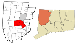
Litchfield County is in northwestern Connecticut, United States. As of the 2020 census, the population was 185,186. The county was named after Lichfield, in England. Litchfield County has the lowest population density of any county in Connecticut and is the state's largest county by area.

<span class="mw-page-title-main">Cornwall, Connecticut</span> Town in Connecticut, United States

Cornwall is a town in Litchfield County, Connecticut, United States. The population was 1,567 at the 2020 census. The town is part of the Northwest Hills Planning Region.

<span class="mw-page-title-main">Harwinton, Connecticut</span> Town in Connecticut, United States

Harwinton is a town in Litchfield County, Connecticut, United States. The population was 5,484 at the 2020 census. The town is part of the Northwest Hills Planning Region. The high school is Lewis S. Mills.

<span class="mw-page-title-main">Morris, Connecticut</span> Town in Connecticut, United States

Morris is a town in Litchfield County, Connecticut, United States. The population was 2,256 at the 2020 census. The town is part of the Northwest Hills Planning Region.

<span class="mw-page-title-main">New Hartford, Connecticut</span> Town in Connecticut, United States

New Hartford is a town in Litchfield County, Connecticut, United States. The population was 6,658 at the 2020 census. The town is part of the Northwest Hills Planning Region. The town center is defined by the U.S. Census Bureau as the New Hartford Center census-designated place (CDP). The town is mainly a rural community consisting of farms, homes, and parks. Brodie Park and Ski Sundown are located in New Hartford.

<span class="mw-page-title-main">Norfolk, Connecticut</span> Town in Connecticut, United States

Norfolk is a town in Litchfield County, Connecticut, United States. The population was 1,588 at the 2020 census. The town is part of the Northwest Hills Planning Region. The urban center of the town is the Norfolk census-designated place, with a population of 553 at the 2010 census.

<span class="mw-page-title-main">Salisbury, Connecticut</span> Town in Connecticut, United States

Salisbury is a town situated in Litchfield County, Connecticut, United States. The town is the northwesternmost in the state of Connecticut; the Massachusetts-New York-Connecticut tri-state marker is located at the northwest corner of the town. The population was 4,194 at the 2020 census. The town is part of the Northwest Hills Planning Region.

<span class="mw-page-title-main">Thomaston, Connecticut</span> Town in Connecticut, United States

Thomaston is a town in Litchfield County, Connecticut, United States. The town is part of the Naugatuck Valley Planning Region. The population was 7,442 at the 2020 census. The urban center of the town is the Thomaston census-designated place, with a population of 1,928 at the 2020 census.

<span class="mw-page-title-main">Winchester, Connecticut</span> Town in Connecticut, United States

Winchester is a town in Litchfield County, Connecticut, United States. The population was 10,224 at the 2020 census. The city of Winsted is located in Winchester. The town is part of the Northwest Hills Planning Region.

<span class="mw-page-title-main">Wolcott, Connecticut</span> Town in Connecticut, United States

Wolcott is a town in New Haven County, Connecticut, United States. The town is part of the Naugatuck Valley Planning Region. It is primarily residential, with a population of 16,142 as of the 2020 United States Census.

<span class="mw-page-title-main">Torrington, Connecticut</span> City in Connecticut, United States

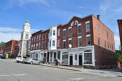
Torrington is the most populated municipality and largest city in Litchfield County, Connecticut, United States, and the Northwest Hills Planning Region. It is also the core city of Greater Torrington, one of the largest micropolitan areas in the United States. The city population was 35,515 according to the 2020 census. The city is located roughly 23 miles (37 km) west of Hartford, 34 miles (55 km) southwest of Springfield, Massachusetts, 67 miles (108 km) southeast of Albany, New York, 84 miles (135 km) northeast of New York City, and 127 miles (204 km) west of Boston, Massachusetts.

<span class="mw-page-title-main">Oliver Wolcott</span> American Founding Father and politician

Oliver Wolcott Sr. was an American Founding Father and politician. He was a signer of the United States Declaration of Independence and the Articles of Confederation as a representative of Connecticut, and the nineteenth governor of Connecticut. Wolcott was a major general for the Connecticut militia in the Revolutionary War serving under George Washington.

<span class="mw-page-title-main">William W. Ellsworth</span> American judge

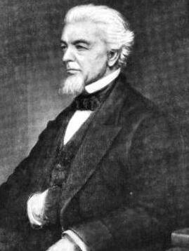
William Wolcott Ellsworth was a Yale-educated attorney who served as the 30th governor of Connecticut, a three-term United States Congressman, a justice of the State Supreme Court.

<span class="mw-page-title-main">Litchfield Hills</span> Region of the state of Connecticut, U.S.

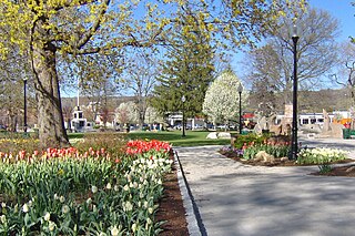
The Litchfield Hills are a geographic region of the U.S. state of Connecticut located in the northwestern corner of the state. It is roughly coterminous with the boundaries of Litchfield County, for which it is named. The geographic region includes colloquial subregions—rural Northwestern Connecticut and the area associated with the city of Torrington, also known as the Upper Naugatuck River Valley or simply Litchfield Hills—which have also variously corresponded to designated government councils both past and present. Much of the area makes up the lowermost section of the Berkshires and is culturally similar to the rest of western New England.

<span class="mw-page-title-main">Tapping Reeve</span> American lawyer, judge and law educator (1744-1823)

Tapping Reeve was an American lawyer, judge, and law educator. In 1784 he opened the Litchfield Law School, the first law school in the United States, in Litchfield, Connecticut.

<span class="mw-page-title-main">Litchfield Law School</span> United States historic place

The Litchfield Law School was a law school in Litchfield, Connecticut, that operated from 1774 to 1833. Litchfield was the first independent law school established in America for reading law. Founded and led by lawyer Tapping Reeve, the proprietary school was unaffiliated with any college or university. While Litchfield was independent, a long-term debate resulted in the 1966 recognition of William & Mary Law School as the first law school to have been affiliated with a university.

<span class="mw-page-title-main">Connecticut's 5th congressional district</span> U.S. House district for Connecticut

Connecticut's 5th congressional district is a congressional district in the U.S. state of Connecticut. Located in the western part of the state and spanning across parts of Fairfield, Litchfield, New Haven, and Hartford Counties, the district runs from Meriden and New Britain in central Connecticut, westward to Danbury and the surrounding Housatonic Valley, encompassing the Farmington Valley, Upper Naugatuck River Valley, and the Litchfield Hills. The district also includes most of Waterbury.

<span class="mw-page-title-main">Litchfield Female Academy</span> Defunct educational institution in Litchfield, Connecticut, United States

The Litchfield Female Academy in Litchfield, Connecticut, founded in 1792 by Sarah Pierce, was one of the most important institutions of female education in the United States. During the 30 years after its opening the school enrolled more than 2,000 students from 17 states and territories of the new republic, as well as Canada and the West Indies. Some 1,848 students known to have attended the school have been identified through school lists, diaries and journals, correspondence, as well as art and needlework done at the school. Many more, unidentified to date, attended, especially before 1814, when formal attendance lists were first kept. The longevity of the school, the size of the enrollments, the wide geographic distribution of the student body, the development of the curriculum and the training of teachers, all distinguish it from the numerous other female academies of the Early Republic. The young women were exposed to ideas and customs from all the relatively isolated parts of the new nation, developing a more national perspective than most Americans of the period.

<span class="mw-page-title-main">John Allen (Connecticut politician)</span> American politician

John Allen was an eighteenth-century lawyer and politician. He served as a United States representative from Connecticut and as a member of the Connecticut Supreme Court of Errors.

<span class="mw-page-title-main">Canaan, Connecticut</span> Town in Connecticut, United States

Canaan is a town in Litchfield County, Connecticut, United States. The population was 1,080 at the 2020 census, down from 1,234 at the 2010 census. The town is part of the Northwest Hills Planning Region. The town of Canaan is often referred to locally by the name of its principal settlement, Falls Village.

References

  1. "Litchfield Connecticut". City-Data.com. Retrieved November 4, 2012.
  2. "2019 U.S. Gazetteer Files". United States Census Bureau. Retrieved July 2, 2020.
  3. "Find a County". National Association of Counties. Retrieved June 7, 2011.
  4. "Census - Geography Profile: Litchfield town, Litchfield County, Connecticut". United States Census Bureau . Retrieved December 17, 2021.
  5. 1 2 3 Chisholm, Hugh, ed. (1911). "Litchfield"  . Encyclopædia Britannica . Vol. 16 (11th ed.). Cambridge University Press. p. 783.
  6. The Connecticut Magazine: An Illustrated Monthly. Connecticut Magazine Company. 1903. p. 332.
  7. A LITCHFIELD JAIL FOR BEN FRANKLIN'S SON Retrieved January 30, 2019
  8. Dictionary of Canadian Biography - Mathews, David Retrieved January 30, 2019
  9. Bulkeley, Alice Talcott (1907). Historic Litchfield, 1721-1907. The Case, Lockwood & Brainard Company. p.  15.
  10. Oman, Nate (August 15, 2006). "The Oldest Law School". Concurring Opinions. Archived from the original on February 19, 2018.
  11. Catalogue of the Litchfield Law School. Hartford, CT: Press of Case, Tiffany and Company. 1849.
  12. "Litchfield Historical Society". Litchfield Historical Society. Retrieved August 2, 2020.
  13. "Census of Population and Housing". Census.gov. Retrieved June 4, 2015.
  14. "U.S. Census website". United States Census Bureau . Retrieved January 31, 2008.
  15. "Registration and Party Enrollment Statistics as of October 31, 2023" (PDF). Connecticut Secretary of State. Retrieved March 4, 2024.
  16. Cooper, Anneliese (June 6, 2014). "'Orange Is the New Black's Prison Location Isn't Real, But It's Not Entirely Fictional Either". Bustle . Retrieved August 4, 2017.
  17. 1 2 Ryan, Bill (October 16, 1994). "Litchfield's Jail Begins Another Era With Women Hoping for New Lives". The New York Times . Retrieved August 5, 2017.
  18. Taylor, Alex (May 22, 2009). "Rehab center closing: McCauliffe Manor's contract expires". The Register Citizen . Retrieved August 5, 2017.
  19. Alfred S. Dillistin (June 1949). "Shepaug Epic". The Lure of the Litchfield Hills. Retrieved April 30, 2014.
  20. [formanschool.org "Forman School - Private School for Students with ADHD & Dyslexia"]. Retrieved April 6, 2022.{{cite web}}: Check |url= value (help)
  21. "ADAMS, Andrew, (1736–1797)". Biographical Directory of the United States Congress. Retrieved November 4, 2012.
  22. Pallastrelli, Gottardo (2018). Ritratto di signora in viaggio : un'americana cosmopolita nel mondo di Henry James[Portrait of a Travelling Lady] (eBook) (in Italian). Roma: Donzelli editore. ISBN   978-88-6843-7770.
  23. Skinner, Charles. "Bell Casting in Troy". Meneeley Bell Online Museum. Archived from the original on June 30, 2014. Retrieved July 12, 2013.
  24. "HOLMES, Uriel, (1764–1827)". Biographical Directory of the United States Congress. Retrieved November 4, 2012.
  25. "Isabella Beecher Hooker". Connecticut Women's Hall of Fame. Retrieved May 23, 2014.
  26. "Susan Saint James". Connecticut Women's Hall of Fame. Retrieved May 23, 2014.
  27. "Madeleine L'Engle". IMDb. Retrieved November 4, 2012.
  28. "MINER, Phineas, (1777–1839)". Biographical Directory of the United States Congress. Retrieved November 4, 2012.
  29. History of Texas, together with a biographical history of the cities of Houston and Galveston. Chicago: Lewis Publishing Company. 1895. pp.  393–396.
  30. "PHELPS, Samuel Shethar, (1793–1855)". Biographical Directory of the United States Congress. Retrieved November 4, 2012.
  31. Ullery, Jacob G. (1894). Men of Vermont Illustrated. Brattleboro, VT: Transcript Publishing Company. pp.  183–184.
  32. Men of Vermont Illustrated.
  33. "Mary L. Ripley, Smithsonian Leader". The Washington Times. Retrieved November 10, 2012.
  34. "Biography, Richard Skinner". The Ledger: A Database of Students of the Litchfield Law School and the Litchfield Female Academy. Litchfield, CT: Litchfield Historical Society. 2010. Retrieved July 8, 2017.
  35. "TALLMADGE, Benjamin, (1754–1835)". Biographical Directory of the United States Congress. Retrieved November 4, 2012.
  36. "Connecticut Governor Oliver Wolcott Jr.publisher=National Governors Association" . Retrieved November 4, 2012.

Further reading