Andover, Connecticut

Last updated

Andover, Connecticut
First Congregational Church, Andover CT.jpg
First Congregational Church (2017)
AndoverCTSeal.png
Tolland County Connecticut Incorporated and Unincorporated areas Andover Highlighted 2010.svg
Capitol Region incorporated and unincorporated areas Andover highlighted.svg
Andover, Connecticut
Coordinates: 41°43′58″N72°22′29″W / 41.73278°N 72.37472°W / 41.73278; -72.37472
CountryFlag of the United States (23px).png  United States
U.S. state Flag of Connecticut.svg  Connecticut
County Tolland
Region Capitol Region
Government
  Type Selectman-town meeting
   First Selectman Jeffrey J. Maguire (D)
  SelectmenJeffrey A. Murray (R)
Anne Peterson Cremè (D)
Scott R. Person (D)
Paula King (R)
Area
  Total15.7 sq mi (40.7 km2)
  Land15.5 sq mi (40.0 km2)
  Water0.2 sq mi (0.6 km2)
Elevation
400 ft (122 m)
Population
 (2020) [1]
  Total3,151
Time zone UTC−5 (Eastern)
  Summer (DST) UTC−4 (Eastern)
ZIP Code
06232
Area code(s) 860/959
FIPS code 09-01080
GNIS feature ID213382
Website andoverconnecticut.org

Andover is a rural town in the Capitol Planning Region, Connecticut, United States, roughly 10 miles east of Hartford. The population was 3,151 at the 2020 census. [2]

Contents

History

Andover was incorporated on May 18, 1848, from Hebron and Coventry. The name is a transfer from Andover, Hampshire, England. [3]

Geography

According to the United States Census Bureau, the town has a total area of 15.7 square miles (41 km2), of which, 15.5 square miles (40 km2) of it is land and 0.2 square miles (0.52 km2) of it (1.53%) is water. A number of small streams and rivers flow in Andover, among which are the Hop River, Burnap Brook, Skungamaug River, and Straddle Brook. Andover Lake is located in the Southeast Corner of town.

Demographics

Historical population
CensusPop.Note
1850 500
1860 5173.4%
1870 461−10.8%
1880 428−7.2%
1890 401−6.3%
1900 385−4.0%
1910 371−3.6%
1920 3894.9%
1930 43010.5%
1940 56030.2%
1950 1,03484.6%
1960 1,77171.3%
1970 2,09918.5%
1980 2,1442.1%
1990 2,54018.5%
2000 3,03619.5%
2010 3,3038.8%
2020 3,151−4.6%
U.S. Decennial Census [4]

As of the 2010 United States Census Andover had a population of 3,304. The racial composition of the population was 95.9% white, 1.1% black or African American, 0.1% Native American, 1.1% Asian, 0.5% from some other race and 1.2% reporting two or more race. 1.6% of the population was Hispanic or Latino of any race. [5]

At the 2000 census there were 3,036 people, 1,150 households, and 861 families living in the town. The population density was 196.4 inhabitants per square mile (75.8/km2). There were 1,198 housing units at an average density of 77.5 per square mile (29.9/km2). The racial makeup of the town was 96.64% White, 0.92% African American, 0.33% Native American, 0.46% Asian, 0.69% from other races, and 0.96% from two or more races. Hispanic or Latino of any race were 1.55%. [6]

Of the 1,150 households 37.5% had children under the age of 18 living with them, 64.3% were married couples living together, 8.0% had a female householder with no husband present, and 25.1% were non-families. 19.0% of households were one person and 5.6% were one person aged 65 or older. The average household size was 2.64 and the average family size was 3.04.

The age distribution was 27.3% under the age of 18, 4.3% from 18 to 24, 34.9% from 25 to 44, 25.7% from 45 to 64, and 7.7% 65 or older. The median age was 38 years. For every 100 females, there were 102.1 males. For every 100 females age 18 and over, there were 98.2 males.

The median household income was $92,822, and the median family income was $45,234. Males had a median income of $21,543 versus $18,167 for females. The per capita income for the town was $30,273. About 2.3% of families and 3.6% of the population were below the poverty line, including 2.8% of those under age 18 and 4.8% of those age 65 or over.

Infrastructure

Route 6 runs roughly Northwest-Southeast through the center of town, connecting Andover to the nearby communities of Windham and Bolton. There is also a library in Andover. Originally opened in 1896, in the Congregational Church Conference House, it was relocated in 1927 to its present location on Long Hill Road.

Points of interest

Education

Andover is home to Andover Elementary School for grades K–6 while grades 7–12 go to R.H.A.M. middle and high schools. [8]

Politics

Voter Registration and Party Enrollment as of October 29, 2019 [9]
PartyActive VotersInactive VotersTotal VotersPercentage
Democratic 697069731.87%
Republican 614061428.07%
Unaffiliated 836183738.27%
Minor Parties 390391.78%
Total2,18612,187100%
Presidential Election Results [10] [11]
Year Democratic Republican Third Parties
2020 50.6%1,05847.7% 9981.7% 35
2016 47.0%89646.7% 8916.3% 121
2012 55.1%97643.7% 7741.2% 22
2008 58.4%1,09039.9% 7451.7% 31
2004 54.4%98044.1% 7961.5% 28
2000 54.9%87138.2% 6096.9% 111
1996 48.5%71132.7% 48018.8% 275
1992 40.0%63430.2% 48029.8% 472
1988 47.5% 60450.9%6491.6% 21
1984 36.5% 43563.5%7580.00% 0
1980 32.5% 37447.9%55219.6% 226
1976 47.8% 48751.6%5260.6% 6
1972 41.3% 44657.7%6241.0% 11
1968 44.0% 41949.1%4696.9% 66
1964 52.3%55647.7% 5080.00% 0
1960 46.6% 39156.4%5050.00% 0
1956 32.7% 24067.3%4940.00% 0

Related Research Articles

<span class="mw-page-title-main">Terramuggus, Connecticut</span> Census-designated place in Connecticut, United States

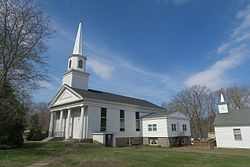
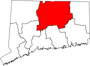
Terramuggus is a census-designated place (CDP) in the town of Marlborough, Hartford County, Connecticut, United States. It contains the town center village and surrounding areas. The population was 1,025 at the 2010 census.

<span class="mw-page-title-main">Bantam, Connecticut</span> Borough in Connecticut, United States

Bantam is a borough in Litchfield County, Connecticut, United States. The population was 720 at the 2020 census. It is part of the town of Litchfield.

Long Lake is an unincorporated community and census-designated place (CDP) in Lake County, Illinois, United States. Per the 2020 census, the population was 3,663.

<span class="mw-page-title-main">Spurgeon, Indiana</span> Town in Indiana, United States

Spurgeon is a town in Monroe Township, Pike County, in the U.S. state of Indiana. The population was 207 at the 2010 census. It is part of the Jasper Micropolitan Statistical Area.

<span class="mw-page-title-main">Andover, Kansas</span> City in Butler County, Kansas

Andover is a city in Butler County, Kansas, United States, and a suburb of Wichita. As of the 2020 census, the population of the city was 14,892. Andover is the most populated city in Butler County.

<span class="mw-page-title-main">Elk Falls, Kansas</span> City in Elk County, Kansas

Elk Falls is a city in Elk County, Kansas, United States, along the Elk River. As of the 2020 census, the population of the city was 113.

<span class="mw-page-title-main">Burlingame, Kansas</span> City in Osage County, Kansas

Burlingame is a city in Osage County, Kansas, United States. As of the 2020 census, the population of the city was 971.

<span class="mw-page-title-main">Lauderdale, Minnesota</span> City in Minnesota, United States

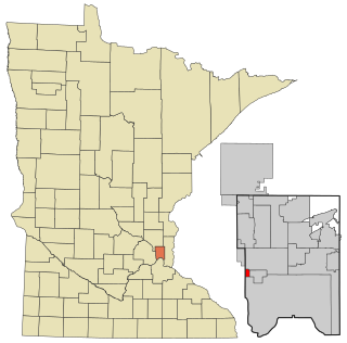
Lauderdale is a city in Ramsey County, Minnesota, United States. The population was 2,379 at the 2010 census. Lauderdale is part of the Minneapolis–St. Paul metropolitan area and is surrounded by Minneapolis, St. Paul, Roseville, and Falcon Heights. Along with Roseville, it is one of two cities to touch both Minneapolis and St Paul.

Boardman is a town in Columbus County, North Carolina, United States. Per the 2020 census, the population was 166.

<span class="mw-page-title-main">Hassell, North Carolina</span> Town in North Carolina, United States

Hassell is a town in Martin County, North Carolina, United States. The population was 84 at the 2010 census.

<span class="mw-page-title-main">Andover, Ohio</span> Village in Ohio, United States

Andover is a village located in the south-east of Ashtabula County, Ohio, United States. The population was 972 at the time of the 2020 census.

<span class="mw-page-title-main">North Kingsville, Ohio</span> Village in Ohio, United States

North Kingsville is a village in Ashtabula County, Ohio, United States. The population was 2,742 at the 2020 census.

<span class="mw-page-title-main">Ninnekah, Oklahoma</span> Town in Oklahoma, United States

Ninnekah is a town in Grady County, Oklahoma, United States. The population was 775 at the 2020 census, a 22.7% decrease from 2010.

<span class="mw-page-title-main">Andover, South Dakota</span> Town in South Dakota, United States

Andover is a town in northwestern Day County, South Dakota, United States. The population was 66 at the 2020 census.

<span class="mw-page-title-main">Andover, Vermont</span> Town in Vermont, United States

Andover is a town in Windsor County, Vermont, United States. The population was 568 at the 2020 census.

<span class="mw-page-title-main">New Haven, West Virginia</span> Town in West Virginia, United States

New Haven is a town in Mason County, West Virginia, United States, along the Ohio River. The population was 1,485 at the 2020 census. It is part of the Point Pleasant, WV–OH Micropolitan Statistical Area.

<span class="mw-page-title-main">Northfork, West Virginia</span> Town in West Virginia, United States

Northfork is a town in McDowell County, West Virginia, United States, located on U.S. Route 52 between Welch and Bluefield.

<span class="mw-page-title-main">Andover (CDP), Massachusetts</span> Census-designated place in Massachusetts, United States

Andover is a census-designated place (CDP) in the town of Andover in Essex County, Massachusetts, United States. The population was 8,762 at the 2010 census.

Andover is a village located in the town of Andover in Allegany County, New York, United States. The population was 1,042 at the 2010 census. The name is derived from Andover, Vermont.

Andover is a town in Allegany County, New York, United States. The population was 1,634 at the 2020 census. The town is on the eastern edge of Allegany County and contains the village of Andover.

References

  1. U.S. Census Bureau Population Estimates
  2. "Census - Geography Profile: Andover town, Tolland County, Connecticut" . Retrieved November 25, 2021.
  3. The Connecticut Magazine: An Illustrated Monthly. Connecticut Magazine Company. 1903. p. 330.
  4. "Census of Population and Housing". Census.gov. Retrieved June 4, 2015.
  5. 2010 race and Hispanic or Latino by place chart for Connecticut from the US Census
  6. "U.S. Census website". United States Census Bureau . Retrieved January 31, 2008.
  7. Rodriguez Jr., Ismael. "'We've Been Fighting This for 55 Years'", VFW Magazine, volume 109, number 2, October 2021, pages 42-43.
  8. Link text
  9. "Registration and Party Enrollment Statistics as of October 29, 2019" (PDF). Connecticut Secretary of State. Retrieved February 17, 2020.
  10. "General Election Statements of Vote, 1922 – Current". CT Secretary of State. Retrieved May 8, 2020.
  11. "Election Night Reporting". CT Secretary of State. Retrieved December 14, 2020.