Goshen, Connecticut

Last updated

Goshen, Connecticut
Town of Goshen
GoshenAcademy 557.jpg
Goshen Academy building
GoshenCTseal.JPG
Litchfield County Connecticut Incorporated and Unincorporated areas Goshen Highlighted 2010.svg
Goshen, Connecticut
Goshen, Connecticut
Goshen, Connecticut
Coordinates: 41°51′05″N73°14′09″W / 41.85139°N 73.23583°W / 41.85139; -73.23583
CountryFlag of the United States.svg  United States
U.S. state Flag of Connecticut.svg  Connecticut
County Litchfield
Region Northwest Hills
Incorporated1739
Government
  Type Selectman-town meeting
  First selectmanTodd Q. Carusillo (R)
  SelectmanMark S. Harris (R)
  SelectmanDexter Kinsella (D)
Area
  Total45.2 sq mi (117.0 km2)
  Land43.6 sq mi (113.0 km2)
  Water1.5 sq mi (4.0 km2)
Elevation
1,319 ft (402 m)
Population
 (2020)
  Total3,150
  Density70/sq mi (27/km2)
Time zone UTC-5 (Eastern)
  Summer (DST) UTC-4 (Eastern)
ZIP code
06756
Area code(s) 860/959
FIPS code 09-32290
GNIS feature ID0213433
Website www.goshenct.gov

Goshen is a town in Litchfield County, Connecticut, United States. The population was 3,150 at the 2020 census. [1] The town is part of the Northwest Hills Planning Region.

Contents

Geography

Goshen is in central Litchfield County and is bordered to the east by the city of Torrington. According to the United States Census Bureau, the town of Goshen has a total area of 45.2 square miles (117.0 km2), of which 43.6 square miles (113.0 km2) are land and 1.5 square miles (4.0 km2), or 3.44%, are water. [2] A large portion of the Mohawk State Forest is located in the town. The Appalachian Trail formerly passed through the town until it was re-routed west of the Housatonic River.

Principal communities

Other minor communities and geographic areas in the town are Hall Meadow, North Goshen, Tyler Lake, West Side, and Woodridge Lake. Woodridge Lake is private. It is only available to residents (it is not a gated community). They have access to the clubhouse, and all of the lake's beaches.

History

The town was incorporated in 1739, one year after settlement of the town center began. The community was named after the Land of Goshen, in Egypt. [3] The Congregational church was founded the following year. [4] During the 18th century, Goshen was a farming, and later, prosperous business community. Gunmakers from the town such as the Medad Hills manufactured guns during the French and Indian War and Revolutionary War. Other notable business include the Pine Apple Cheese Factory and the Brooks pottery shop.

The first school in Goshen was built in 1753. A seminary for young women was established in 1819. The Goshen Academy was established several years later and became a well-regarded preparatory school during the 19th century.

Settlers from Goshen were the first to settle Hudson Township, Summit County, Ohio, in the Connecticut Western Reserve.

Notable locations

Historic sites in the town include:

Transportation

Connecticut Route 4 is the principal east–west through route in the town, while Connecticut Route 63 serves as the main north–south road. Route 4 leads east into Torrington and west into Cornwall, while Route 63 leads northwest to South Canaan and southeast to Litchfield.

Demographics

Historical population
CensusPop.Note
1820 1,585
1850 1,457
1860 1,381−5.2%
1870 1,223−11.4%
1880 1,093−10.6%
1890 972−11.1%
1900 835−14.1%
1910 675−19.2%
1920 6750.0%
1930 6831.2%
1940 77813.9%
1950 94020.8%
1960 1,28837.0%
1970 1,3514.9%
1980 1,70626.3%
1990 2,32936.5%
2000 2,69715.8%
2010 2,97610.3%
2020 3,1505.8%
U.S. Decennial Census [5]

As of the census [6] of 2000, there were 2,697 people, 1,066 households, and 814 families residing in the town. The population density was 61.8 inhabitants per square mile (23.9/km2). There were 1,482 housing units at an average density of 33.9 per square mile (13.1/km2). The racial makeup of the town was 98.26% White, 0.48% African American, 0.15% Native American, 0.74% Asian, and 0.37% from two or more races. Hispanic or Latino of any race were 1.22% of the population.

There were 1,066 households, out of which 29.4% had children under the age of 18 living with them, 67.5% were married couples living together, 5.4% had a female householder with no husband present, and 23.6% were non-families. 20.2% of all households were made up of individuals, and 6.9% had someone living alone who was 65 years of age or older. The average household size was 2.53 and the average family size was 2.91.

In the town, the population was spread out, with 22.7% under the age of 18, 5.3% from 18 to 24, 25.1% from 25 to 44, 31.7% from 45 to 64, and 15.2% who were 65 years of age or older. The median age was 43 years. For every 100 females, there were 97.4 males. For every 100 females age 18 and over, there were 98.5 males.

The median income for a household in the town was $64,432, and the median income for a family was $72,452. Males had a median income of $48,125 versus $30,464 for females. The per capita income for the town was $33,925. About 2.9% of families and 3.3% of the population were below the poverty line, including 4.1% of those under age 18 and 3.9% of those age 65 or over.

Voter registration and party enrollment as of October 25, 2005 [7]
PartyActive votersInactive votersTotal votersPercentage
Republican 7451676137.29%
Democratic 413641920.53%
Unaffiliated 8273386042.14%
Minor Parties 1010.05%
Total1,986552,041100%
Presidential Election Results [8]
Year Democratic Republican Third Parties
2020 43.0% 90255.3%1,1611.7% 37
2016 36.9% 67358.4%1,0644.7% 86
2012 42.0% 75156.9%1,0171.1% 19
2008 47.4% 85651.3%9271.3% 24
2004 42.2% 71556.3%9541.5% 27
2000 39.7% 58553.5%7886.8% 100
1996 39.6% 51845.6%59714.8% 194
1992 31.0% 44741.0%59128.0% 404
1988 33.9% 40364.7%7691.4% 16
1984 29.3% 31870.1%7610.6% 7
1980 29.8% 28656.0%53814.2% 137
1976 34.4% 27964.7%5250.9% 8
1972 30.5% 22567.9%5012.6% 12
1968 34.4% 24061.3%4284.3% 30
1964 51.6%32948.4% 3090.00% 0
1960 31.5% 21468.5%4650.00% 0
1956 20.2% 12379.8%4850.00% 0

Arts and culture

Multiple events are hosted at the Goshen Fairgrounds each year, located on Route 63 south just outside the center of town. One such event is the Goshen Stampede, a festival held annually on Father's Day weekend that hosts a rodeo, demolition derby, music festival, and truck pull. Later in the summer on Labor Day weekend is the annual Goshen Fair. As the county's largest agricultural fair, it features farm animal judgement shows, competition and contest in log chopping, log sawing, hay-bale throwing and the like. There are food, art, photography, baked goods, and craft contests, as well as rides for children, carnival games, and craft and food vendors. Attendance over the three days can range up to 50,000 people.

Traditionally at the beginning of August, and usually the first Saturday, the Church of Christ presents an Annual Blueberry Festival where they sell blueberry pies, blueberries and host a blueberry breakfast. It is very well known and people from all around the area come to enjoy the festival and the pies. The blueberry pies are available for sale all year long, as well as other flavors made by hand by the congregation (apple, peach, and blueberry-peach). Mini pies are also sold by the church at the Goshen Fair.

The town is also home to the Goshen Players.

Notable people

Related Research Articles

<span class="mw-page-title-main">Litchfield County, Connecticut</span> County in Connecticut, United States

Litchfield County is in northwestern Connecticut, United States. As of the 2020 census, the population was 185,186. The county was named after Lichfield, in England. Litchfield County has the lowest population density of any county in Connecticut and is the state's largest county by area.

<span class="mw-page-title-main">Bethlehem, Connecticut</span> Town in Connecticut, United States

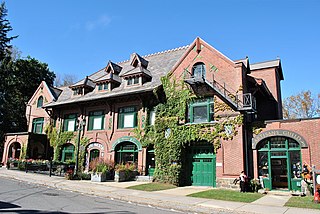
Bethlehem is a town in Litchfield County, Connecticut, United States. The population was 3,385 at the 2020 census, down from 3,607 at the 2010 census. The town is part of the Naugatuck Valley Planning Region. The town center is a historic district and a census-designated place (CDP).

<span class="mw-page-title-main">Bridgewater, Connecticut</span> Town in Connecticut, United States

Bridgewater is a town in Litchfield County, Connecticut, United States. The population was 1,662 at the 2020 census, down from 1,727 at the 2010 census. The town is part of the Western Connecticut Planning Region.

<span class="mw-page-title-main">Colebrook, Connecticut</span> Town in Connecticut, United States

Colebrook is a town in Litchfield County, Connecticut, United States. The population was 1,361 at the 2020 census. The town is part of the Northwest Hills Planning Region. Colebrook was named after Colebrooke in the English county of Devon; the reason is now unknown.

<span class="mw-page-title-main">Cornwall, Connecticut</span> Town in Connecticut, United States

Cornwall is a town in Litchfield County, Connecticut, United States. The population was 1,567 at the 2020 census. The town is part of the Northwest Hills Planning Region.

<span class="mw-page-title-main">Harwinton, Connecticut</span> Town in Connecticut, United States

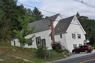
Harwinton is a town in Litchfield County, Connecticut, United States. The population was 5,484 at the 2020 census. The town is part of the Northwest Hills Planning Region. The high school is Lewis S. Mills.

<span class="mw-page-title-main">New Hartford, Connecticut</span> Town in Connecticut, United States

New Hartford is a town in Litchfield County, Connecticut, United States. The population was 6,658 at the 2020 census. The town is part of the Northwest Hills Planning Region. The town center is defined by the U.S. Census Bureau as the New Hartford Center census-designated place (CDP). The town is mainly a rural community consisting of farms, homes, and parks. Brodie Park and Ski Sundown are located in New Hartford.

<span class="mw-page-title-main">Norfolk, Connecticut</span> Town in Connecticut, United States

Norfolk is a town in Litchfield County, Connecticut, United States. The population was 1,588 at the 2020 census. The town is part of the Northwest Hills Planning Region. The urban center of the town is the Norfolk census-designated place, with a population of 553 at the 2010 census.

<span class="mw-page-title-main">Northwest Harwinton, Connecticut</span> Census-designated place in Connecticut, United States

Northwest Harwinton is a census-designated place (CDP) in the town of Harwinton in Litchfield County, Connecticut, United States. The population was 3,158 at the 2020 census, out of 5,484 in the entire town. The CDP contains the town center.

<span class="mw-page-title-main">Plymouth, Connecticut</span> Town in Connecticut, United States

Plymouth is a town in Litchfield County, Connecticut, United States, located within the Naugatuck Valley Planning Region. It is named after Plymouth, Devon, England. The population was 11,671 at the 2020 census, down from 12,243 at the 2010 census. The town of Plymouth includes the villages of Plymouth Center, Terryville and Pequabuck.

<span class="mw-page-title-main">Roxbury, Connecticut</span> Town in Connecticut, United States

Roxbury is a town in Litchfield County, Connecticut, United States. The population was 2,260 at the 2020 census. The town is located 65 miles (105 km) northeast of New York City, and is part of the Northwest Hills Planning Region.

<span class="mw-page-title-main">Thomaston, Connecticut</span> Town in Connecticut, United States

Thomaston is a town in Litchfield County, Connecticut, United States. The town is part of the Naugatuck Valley Planning Region. The population was 7,442 at the 2020 census. The urban center of the town is the Thomaston census-designated place, with a population of 1,928 at the 2020 census.

<span class="mw-page-title-main">Warren, Connecticut</span> Town in Connecticut, United States

Warren is a town in Litchfield County, Connecticut, United States. The population was 1,351 at the 2020 census. The town is part of the Northwest Hills Planning Region. The town was named for Revolutionary War General Joseph Warren.

<span class="mw-page-title-main">Watertown, Connecticut</span> Town in Connecticut, United States

Watertown is a town in Litchfield County, Connecticut, United States. The town is part of the Naugatuck Valley Planning Region. The population was 22,105 at the 2020 census. The ZIP Codes for Watertown are 06795 and 06779. It is a suburb of Waterbury. The urban center of the town is the Watertown census-designated place, with a population of 3,938 at the 2020 census.

<span class="mw-page-title-main">Winchester, Connecticut</span> Town in Connecticut, United States

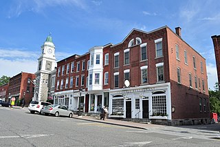
Winchester is a town in Litchfield County, Connecticut, United States. The population was 10,224 at the 2020 census. The city of Winsted is located in Winchester. The town is part of the Northwest Hills Planning Region.

<span class="mw-page-title-main">Middlebury, Connecticut</span> Town in Connecticut, United States

Middlebury is a town in New Haven County, Connecticut, United States. The population was 7,574 at the 2020 census. The town is part of the Naugatuck Valley Planning Region.

<span class="mw-page-title-main">Goshen, New Hampshire</span> Place in New Hampshire, United States

Goshen is a town in Sullivan County, New Hampshire, United States. The population was 796 at the 2020 census.

<span class="mw-page-title-main">Litchfield, Connecticut</span> Town in Connecticut, United States

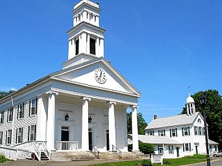
Litchfield is a town in and former county seat of Litchfield County, Connecticut, United States. The population was 8,192 at the 2020 census. The town is part of the Northwest Hills Planning Region. The boroughs of Bantam and Litchfield are located within the town. There are also three unincorporated villages: East Litchfield, Milton, and Northfield. Northfield, located in the southeastern corner of Litchfield, is home to a high percentage of the Litchfield population.

<span class="mw-page-title-main">Canaan, Connecticut</span> Town in Connecticut, United States

Canaan is a town in Litchfield County, Connecticut, United States. The population was 1,080 at the 2020 census, down from 1,234 at the 2010 census. The town is part of the Northwest Hills Planning Region. The town of Canaan is often referred to locally by the name of its principal settlement, Falls Village.

<span class="mw-page-title-main">Litchfield (borough), Connecticut</span> Borough in Connecticut, United States

Litchfield is a borough in, and the village center of, the town of Litchfield in Litchfield County, Connecticut, United States. The population was 1,258 at the 2010 census. The entire borough was designated a Connecticut historic district in 1959 by special act of the state General Assembly and is listed on the National Register of Historic Places. Part of the borough is also a National Historic Landmark, the Litchfield Historic District.

References

  1. "Census - Geography Profile: Goshen town, Litchfield County, Connecticut". United States Census Bureau . Retrieved December 16, 2021.
  2. "Geographic Identifiers: 2010 Census Summary File 1 (G001), Goshen town, Litchfield County, Connecticut". American FactFinder. U.S. Census Bureau. Archived from the original on February 13, 2020. Retrieved October 7, 2019.
  3. The Connecticut Magazine: An Illustrated Monthly. Connecticut Magazine Company. 1903. p. 332.
  4. "History of the Town of Goshen, Connecticut," Page 72, 1897
  5. "Census of Population and Housing". Census.gov. Retrieved June 4, 2015.
  6. "U.S. Census website". United States Census Bureau . Retrieved January 31, 2008.
  7. "Registration and Party Enrollment Statistics as of October 25, 2005" (PDF). Connecticut Secretary of State. Archived from the original (PDF) on September 23, 2006. Retrieved October 2, 2006.
  8. "General Election Statements of Vote, 1922 – Current". CT Secretary of State. Retrieved December 16, 2021.