Plainfield, Connecticut

Last updated
Plainfield, Connecticut
Town of Plainfield
Former bike shop, Plainfield CT.jpg
Former bike shop that was repurposed to a barbershop in Plainfield Village
PlainfieldCTseal.JPG
Windham County Connecticut incorporated and unincorporated areas Plainfield highlighted.svg
Plainfield, Connecticut
Coordinates: 41°42′N71°54′W / 41.700°N 71.900°W / 41.700; -71.900 Coordinates: 41°42′N71°54′W / 41.700°N 71.900°W / 41.700; -71.900
CountryFlag of the United States.svg  United States
U.S. state Flag of Connecticut.svg  Connecticut
County Windham
Region Northeastern CT
Incorporated1699
Government
  Type Selectman-town meeting
  First selectmanKevin Cunningham
   State Senator Heather Somers
(R-18th District)
   State Reps. Brian Lanoue
(R-45th District)
Anne Dauphinais
(R-44th District)
Area
  Total43.0 sq mi (111.4 km2)
  Land42.3 sq mi (109.5 km2)
  Water0.8 sq mi (2.0 km2)
Elevation
400 ft (122 m)
Population
 (2020)
  Total14,973
  Density354/sq mi (136.7/km2)
Time zone UTC-5 (Eastern)
  Summer (DST) UTC-4 (Eastern)
ZIP code
06354, 06374
Area code(s) 860/959
FIPS code 09-59980
GNIS feature ID0213487
Website www.plainfieldct.org

Plainfield is a town in Windham County, Connecticut, United States. The town is part of the Northeastern Connecticut Planning Region. The population was 14,973 at the 2020 census. [1] The town comprises four villages: Plainfield (south, ZIP code 06374), Moosup (northeast, 06354), Wauregan (northwest, 06387), and Central Village (west, 06332). Each village has their own respective United States Post Office and fire department. The entire town is serviced by the 860 area code.

Contents

History

Plainfield was incorporated in 1699 as the town of Quinebaug and renamed the following year to its current name. The present name of "Plainfield" is descriptive of the original town site. [2] Plainfield proved to be an industrial heavyweight in the 19th and early 20th centuries due largely to the ability of the Moosup and Quinebaug Rivers to provide power to the different mills throughout town. The job opportunities attracted French Canadian Americans, Irish Americans, British Americans, and people from other countries during the late 19th century. Combined with the mills, Plainfield had incredible commerce for a small town because four railways from Hartford, New York, Boston, and Providence intersected within the town. There was also a highly acclaimed school on Academy Hill, which is how the present Academy Hill Road got its name. Also, the town annually has the V-J Day parade; in fact, the oldest in the United States.

Sites in Plainfield that are listed on the National Register of Historic Places are:

Geography

Plainfield is located at: 41.6775 N, 71.9220 W.

According to the United States Census Bureau, the town has a total area of 43 square miles (110 km2), of which, 42.3 square miles (110 km2) of it is land and 0.8 square miles (2.1 km2) of it (1.81%) is water. From the southernmost point, Plainfield is 20 miles (32 km) inland of the Long Island Sound and Block Island Sound (Atlantic Ocean). Plainfield is the southernmost town of Windham County. The Quinebaug River generally forms the western border of the town. The Moosup River feeds the Quinebaug and runs across the northern portion of town.

Transportation

Plainfield is bisected by the Connecticut Turnpike (I-395 and CT 695) and is serviced by three exits: Lathrop Road at exit 28, CT 14A at exit 29, and CT 14 at exit 32. All exits are off the I-395 portion of the Turnpike, which runs north and south. Exit 35 off I-395 North is in Plainfield, but does not offer access to any Plainfield streets. CT 12 generally runs parallel to the west of the Turnpike, and is less than one-half mile from all three Turnpike exits.

There is no direct air, passenger rail, or navigable water access to Plainfield, although the town is serviced by the Providence and Worcester Railroad (freight only), which also parallels the Connecticut Turnpike corridor. There is limited public transport system available in the town; combined with a lack of a sidewalk and/or segregated cycle facilities network and the large area of the town, this necessitates that most transit is done by car.

Providence, RI is the closest major city, 30 miles (48 km) to the east. Hartford is 40 miles (64 km) west. Boston, MA is 60 miles (97 km) northeast; New York City (Manhattan), NY is 120 miles (190 km) southwest. The closest international airport is T. F. Green Airport (PVD) in Warwick, RI. Nearby Amtrak passenger rail stations include New London (NLC) and Providence (PVD); both are roughly 40 minute drives. New London is also served by the Shore Line East commuter railroad, and Providence by Massachusetts Bay Transportation Authority (MBTA) Commuter Rail.

Demographics

Historical population
CensusPop.Note
1820 2,097
1840 2,383
1850 2,73214.6%
1860 3,66534.2%
1870 4,52123.4%
1880 4,021−11.1%
1890 4,58214.0%
1900 4,8215.2%
1910 6,71939.4%
1920 7,92618.0%
1930 8,0271.3%
1940 7,613−5.2%
1950 8,0716.0%
1960 8,88410.1%
1970 11,95734.6%
1980 12,7746.8%
1990 14,36312.4%
2000 14,6191.8%
2010 15,4055.4%
2020 14,973−2.8%
U.S. Decennial Census [3]

As of the census [4] of 2000, there were 14,619 people, 5,444 households, and 3,908 families residing in the town. The population density was 345.9 inhabitants per square mile (133.6/km2). There were 5,676 housing units at an average density of 134.3 per square mile (51.9/km2). The racial makeup of the town was 96.15% White, 0.78% African American, 0.53% Native American, 0.60% Asian, 0.03% Pacific Islander, 0.63% from other races, and 1.29% from two or more races. Hispanic or Latino of any race were 2.63% of the population.

There were 5,444 households, out of which 36.6% had children under the age of 18 living with them, 53.6% were married couples living together, 13.1% had a female householder with no husband present, and 28.2% were non-families. 21.4% of all households were made up of individuals, and 8.6% had someone living alone who was 65 years of age or older. The average household size was 2.65 and the average family size was 3.06.

In the town, the population was spread out, with 26.9% under the age of 18, 8.0% from 18 to 24, 32.1% from 25 to 44, 21.6% from 45 to 64, and 11.5% who were 65 years of age or older. The median age was 35 years. For every 100 females, there were 95.8 males. For every 100 females age 18 and over, there were 92.1 males.

The median income for a household in the town was $42,851, and the median income for a family was $47,447. Males had a median income of $36,785 versus $24,026 for females. The per capita income for the town was $18,706. About 5.4% of families and 7.0% of the population were below the poverty line, including 8.2% of those under age 18 and 5.6% of those age 65 or over.

Education

Moosup Free Public Library, c. 1908 PostcardMoosupCTAldrichFreePublicLibrary1913.jpg
Moosup Free Public Library, c.1908

The Plainfield Board of Education (also Plainfield Public Schools) is responsible for the operation of schools, and operates seven facilities throughout the town.

Elementary (K–5)

Middle/Jr. High (6–8)

High (9–12)

Related Research Articles

<span class="mw-page-title-main">New London County, Connecticut</span> County in Connecticut, United States

New London County is in the southeastern corner of Connecticut and comprises the Norwich-New London, Connecticut Metropolitan Statistical Area, which is also included in the Hartford-East Hartford, Connecticut Combined Statistical Area. There is no county government and no county seat, as is the case with all eight of Connecticut's counties; towns are responsible for all local government activities, including fire and rescue, snow removal, and schools.

<span class="mw-page-title-main">Windham County, Connecticut</span> County in Connecticut, United States

Windham County is a county located in the northeastern corner of the U.S. state of Connecticut. As of the 2020 census, the population was 116,418, making it the least populous county in Connecticut. It forms the core of the region known as the Quiet Corner. Windham County is included in the Worcester, MA-CT Metropolitan Statistical Area, which is also included in the Boston-Worcester-Providence, MA-RI-NH-CT Combined Statistical Area. The entire county is within the Quinebaug and Shetucket Rivers Valley National Heritage Corridor, as designated by the National Park Service.

<span class="mw-page-title-main">Lisbon, Connecticut</span> Town in Connecticut, United States

Lisbon is a town in New London County, Connecticut, United States, 7.3 miles (11.7 km) by road northeast of Norwich. The population was 4,195 at the 2020 census. The town center is also known as the village of Newent. The town school is Lisbon Central School. Its only postal code, 06351, is Jewett City, Connecticut, which is a village of the town of Griswold, Connecticut and encompasses all of Lisbon and Griswold.

<span class="mw-page-title-main">Voluntown, Connecticut</span> Town in Connecticut, United States

Voluntown is a town in New London County, Connecticut, United States. The town is part of the Northeastern Connecticut Planning Region. The population was 2,570 at the 2020 census. Voluntown was part of Windham County from 1726 to 1881.

<span class="mw-page-title-main">Andover, Connecticut</span> Town in Connecticut, United States

Andover is a rural town in the Capitol Planning Region, Connecticut, United States, roughly 10 miles West of Hartford. The population was 3,151 at the 2020 census. Andover is home to Andover Elementary School for grades K–6 while grades 7–12 go to R.H.A.M. middle and high schools. Andover elementary scores above average on standardized testing and student development as well as having a notably low student to teacher ratio of 8:1.

<span class="mw-page-title-main">Union, Connecticut</span> Town in Connecticut, United States

Union is a town located in the northeastern part of Tolland County, Connecticut, United States and is part of the Northeastern Connecticut Planning Region and Last Green Valley National Heritage Corridor. The population was 785 at the 2020 census, making it the least populous town in Connecticut. Union includes the village of Mashapaug located in the Eastern Uplands at the Massachusetts state line. Union is located 33 miles northeast of the state capital, Hartford and 67 mi (108 km) southwest of Boston as well as 153 mi (246 km) northeast of New York City.

<span class="mw-page-title-main">Willington, Connecticut</span> Town in Connecticut, United States

Willington is a town in Tolland County, Connecticut, United States. The population was 5,566 at the 2020 census.

<span class="mw-page-title-main">Brooklyn, Connecticut</span> Town in Connecticut, United States

Brooklyn is a town in Windham County, Connecticut, United States. The town is part of the Northeastern Connecticut Planning Region. The population was 8,450 at the 2020 census. The town center village is listed by the U.S. Census Bureau as a census-designated place. The district of East Brooklyn is listed as a separate census-designated place.

<span class="mw-page-title-main">Canterbury, Connecticut</span> Town in Connecticut, United States

Canterbury is a town in Windham County, Connecticut, United States. The town is part of the Northeastern Connecticut Planning Region. The population was 5,045 at the 2020 census.

<span class="mw-page-title-main">Eastford, Connecticut</span> Town in Connecticut, United States

Eastford is a town in Windham County, Connecticut, United States. The town is part of the Northeastern Connecticut Planning Region. The population was 1,649 at the 2020 census.

<span class="mw-page-title-main">Killingly, Connecticut</span> Town in Connecticut, United States

Killingly is a town in Windham County, Connecticut, United States. Killingly is the largest town by population in the Northeastern Connecticut Planning Region. The population was 17,752 at the 2020 census. It consists of the borough of Danielson and the villages of Attawaugan, Ballouville, Dayville, East Killingly, Rogers, and South Killingly.

<span class="mw-page-title-main">Moosup, Connecticut</span> Village in Connecticut, United States

Moosup is a village and census-designated place (CDP) in the town of Plainfield, Connecticut in the United States. The population was 3,231 at the 2010 census.

<span class="mw-page-title-main">Plainfield Village, Connecticut</span> Village in Connecticut, United States

Plainfield Village is a village and census-designated place (CDP) in the town of Plainfield, Connecticut in the United States. The population was 2,557 at the 2010 census. It is located in the southwest part of town, in the area west of I-395 and south of Route 14. The village is also the core of the Plainfield, CT urban cluster.

<span class="mw-page-title-main">Putnam, Connecticut</span> Town in Connecticut, United States

Putnam is a town in Windham County, Connecticut, United States. The town is part of the Northeastern Connecticut Planning Region. The population was 9,224 at the 2020 census.

<span class="mw-page-title-main">Scotland, Connecticut</span> Town in Connecticut, United States

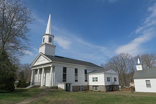
Scotland is a town in Windham County, Connecticut. The town is part of the Northeastern Connecticut Planning Region. As of the 2020 census, the town population was 1,576. Scotland is a predominantly rural town with agriculture as the principal industry. Scotland is the least populated town in Windham County.

<span class="mw-page-title-main">Sterling, Connecticut</span> Town in Connecticut, United States

Sterling is a town in Windham County, Connecticut, United States. The town is part of the Northeastern Connecticut Planning Region. The population was 3,578 at the 2020 census.

<span class="mw-page-title-main">Thompson, Connecticut</span> Town in Connecticut, United States

Thompson is a town in Windham County, Connecticut, United States. The town is part of the Northeastern Connecticut Planning Region. The town was named after Sir Robert Thompson, an English landholder. The population was 9,189 at the 2020 census. Thompson is located in the northeastern corner of the state and is bordered on the north by Webster, Massachusetts and Dudley, Massachusetts, on the east by Douglas, Massachusetts and Burrillville, Rhode Island, on the west by Woodstock, Connecticut, and on the south by Putnam, Connecticut.

<span class="mw-page-title-main">Wauregan, Connecticut</span> United States historic place

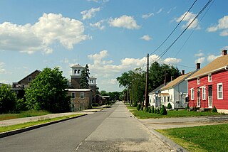
Wauregan is a village located in the northwestern corner of the town of Plainfield, Connecticut in the United States. Originally a mill village, Wauregan was established around a cotton mill powered by the Quinebaug River. Wauregan and West Wauregan, across the Quinebaug in the town of Brooklyn, together comprise the Wauregan census-designated place, with a population of 1,205 at the 2010 census.

<span class="mw-page-title-main">Windham, Connecticut</span> Town in Connecticut, United States

Windham is a town in Windham County, Connecticut, United States. It contains the former city of Willimantic as well as the boroughs of Windham Center, North Windham, and South Windham. Willimantic, an incorporated city since 1893, was consolidated with the town in 1983. The population was 24,428 at the 2020 census.

<span class="mw-page-title-main">Connecticut Route 14</span> State highway in Windham County, Connecticut, US

Connecticut Route 14 is one of several secondary routes from eastern Connecticut into Rhode Island. It runs from the Willimantic section of the town of Windham to the Rhode Island state line in Sterling.

References

  1. "Census - Geography Profile: Plainfield town, Windham County, Connecticut" . Retrieved December 20, 2021.
  2. The Connecticut Magazine: An Illustrated Monthly. Connecticut Magazine Company. 1903. p. 334.
  3. "Census of Population and Housing". Census.gov. Retrieved June 4, 2015.
  4. "U.S. Census website". United States Census Bureau . Retrieved 2008-01-31.