Putnam (CDP), Connecticut

Last updated

Putnam (CDP), Connecticut
Putnam District
Former Montgomery Ward, Putnam CT.jpg
Front of Montgomery Ward Building
Windham County Connecticut incorporated and unincorporated areas Putnam (CDP) highlighted.svg
Location in Windham County and the state of Connecticut.
Coordinates: 41°55′19″N71°54′27″W / 41.92194°N 71.90750°W / 41.92194; -71.90750
Country United States
State Connecticut
County Windham
Town Putnam
Area
  Total3.2 sq mi (8.3 km2)
  Land3.2 sq mi (8.3 km2)
  Water0.04 sq mi (0.10 km2)
Elevation
259 ft (79 m)
Population
 (2010)
  Total7,214
  Density2,300/sq mi (870/km2)
Time zone UTC-5 (Eastern (EST))
  Summer (DST) UTC-4 (EDT)
ZIP code
06260
Area code 860
FIPS code 09-62640
GNIS feature ID2377854 [1]
Website www.putnamct.us

Putnam District is a village [2] and census-designated place (CDP) in Windham County, Connecticut, United States. The CDP was formed when the former city of Putnam disincorporated, and it consists of the main town center of the town of Putnam along the Quinebaug River. The village is part of the Northeastern Connecticut Planning Region. The population was 7,214 at the 2010 census.

Contents

Geography

According to the United States Census Bureau, the CDP has a total area of 3.2 square miles (8.3 km2), of which 3.2 square miles (8.3 km2) is land and 0.04 square miles (0.10 km2) (1.24%) is water.

Demographics

As of the census [3] of 2010, there were 7,214 people, 3,033 households and 1,751 families in the CDP. The population density was 2,239 inhabitants per square mile (864/km2). There were 3,325 housing units at an average density of 1,039 per square mile (401/km2). The racial makeup of the CDP was 93.4% White, 1.5% African American, 0.6% Native American, 1.0% Asian, 0.0% Pacific Islander, 2.7% from other races, and 2.7% from two or more races. Hispanic or Latino of any race were 3.6% of the population.

There were 3,033 households, out of which 26.8% had children under the age of 18 living with them, 36.2% were married couples living together, 15.2% had a female householder with no husband present, and 42.3% were non-families. 33.3% of all households were made up of individuals living alone, and 13.5% had someone living alone who was 65 years of age or older. The average household size was 2.3 and the average family size was 2.9.

In the CDP the population was spread out, with 23.6% under the age of 18, 9.2% from 18 to 24, 28.0% from 25 to 44, 25.6% from 45 to 64, and 13.6% who were 65 years of age or older. The median age was 37 years.

The median income for a household in the CDP was $42,271, and the median income for a family was $51,356. Males had a median income of $48,824 versus $44,476 for females. The per capita income for the CDP was $24,934. About 13.6% of families and 18.0% of the population were below the poverty line, including 23.2% of those under age 18 and 10.7% of those age 65 or over.

Related Research Articles

<span class="mw-page-title-main">Crestline, California</span> Census-designated place in California, United States

Crestline is a census-designated place in the San Bernardino Mountains of San Bernardino County, California, USA. The population was 10,770 at the 2010 census, up from 10,218 at the 2000 census.

<span class="mw-page-title-main">Broad Brook, Connecticut</span> Census-designated place in Connecticut, United States

Broad Brook is a neighborhood and census-designated place (CDP) in the town of East Windsor, Hartford County, Connecticut, United States. As of the 2010 census, the CDP population was 4,069.

<span class="mw-page-title-main">Kensington, Connecticut</span> Census-designated place in Connecticut, United States

Kensington is a census-designated place (CDP) and section of the town of Berlin in Hartford County, Connecticut, United States. The Berlin town offices are located in Kensington. The population was 8,459 at the 2010 census.

<span class="mw-page-title-main">Terramuggus, Connecticut</span> Census-designated place in Connecticut, United States

Terramuggus is a census-designated place (CDP) in the town of Marlborough, Hartford County, Connecticut, United States. It contains the town center village and surrounding areas. The population was 1,025 at the 2010 census.

<span class="mw-page-title-main">Weatogue, Connecticut</span> Census-designated place in Connecticut, United States

Weatogue is a village and census-designated place in Simsbury, Hartford County, Connecticut, United States. The population was 2,776 at the 2010 census.

<span class="mw-page-title-main">Old Mystic, Connecticut</span> Census-designated place in Connecticut, United States

Old Mystic is a village and census-designated place (CDP) located in the town of Groton, Connecticut. The population was 3,554 at the 2010 census.

<span class="mw-page-title-main">East Brooklyn, Connecticut</span> Census-designated place in Connecticut, United States

East Brooklyn is a census-designated place (CDP) located within the town of Brooklyn in Windham County, Connecticut, United States. It is the portion of the Danielson urban cluster within the town of Brooklyn. The population was 2,205 at the 2020 census. US 6 runs through the town and severs the town.

<span class="mw-page-title-main">Oakville, Missouri</span> CDP in Missouri, United States

Oakville is a census-designated place (CDP) in south St. Louis County, Missouri, United States. The population was 36,301 at the 2020 census. Oakville is 18 miles south of the city of St. Louis and borders the Mississippi and Meramec rivers; the area is part of "South County".

<span class="mw-page-title-main">Carmel Hamlet, New York</span> Hamlet and Census-designated place in New York, United States

Carmel Hamlet, commonly known simply as Carmel, is a hamlet and census-designated place (CDP) located in the Town of Carmel in Putnam County, New York, United States. As of the 2010 census, the population was 6,817.

<span class="mw-page-title-main">Putnam Lake, New York</span> Census-designated place in New York, United States

Putnam Lake is a hamlet and census-designated place in the eastern part of the town of Patterson in Putnam County, New York, United States. As of the 2010 census, the population was 3,844. Putnam Lake is adjacent to the Connecticut border, which is crossed by a number of local streets. The community surrounds a lake, which is also called Putnam Lake.

<span class="mw-page-title-main">Covedale, Ohio</span> Census-designated place in Ohio, United States

Covedale is a census-designated place (CDP) in Green Township, Hamilton County, Ohio, United States. The population was 6,472 at the 2020 census. The CDP represents the part of the former village of Covedale that was not annexed by the city of Cincinnati in 1930.

<span class="mw-page-title-main">Grandview, Hamilton County, Ohio</span> Census-designated place in Ohio, United States

Grandview is a census-designated place (CDP) in Hamilton County, Ohio, United States. The population was 1,312 at the 2020 census.

<span class="mw-page-title-main">Sherwood, Hamilton County, Ohio</span> Census-designated place in Ohio, United States

Sherwood is a census-designated place (CDP) in Hamilton County, Ohio, United States. The population was 3,633 at the 2020 census.

<span class="mw-page-title-main">Shiloh, York County, Pennsylvania</span> CDP in Pennsylvania, United States

Shiloh is a census-designated place (CDP) in West Manchester Township, York County, Pennsylvania, United States. The population was 11,218 at the 2010 census.

<span class="mw-page-title-main">Antelope, South Dakota</span> CDP in South Dakota, United States

Antelope is a census-designated place (CDP) in Todd County, South Dakota, United States. The population was 830 at the 2020 census.

<span class="mw-page-title-main">Bethel (CDP), Connecticut</span> Census-designated place in Connecticut, United States

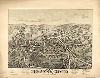
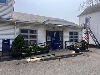
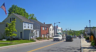
Bethel is a census-designated place (CDP) in Fairfield County, Connecticut, United States. It comprises the primary village and surrounding residential land within the town of Bethel. As of the 2010 census, the population of the CDP was 9,549, out of 18,584 in the entire town.

<span class="mw-page-title-main">Southold (CDP), New York</span> Hamlet and census-designated place in New York, United States

Southold is a census-designated place (CDP) that generally corresponds to the hamlet by the same name in the Town of Southold in Suffolk County, New York, United States. The CDP population was 5,748 at the 2010 census.

<span class="mw-page-title-main">Glastonbury Center, Connecticut</span> Census-designated place in Connecticut, United States

Glastonbury Center is a census-designated place (CDP) that constitutes the densely populated center of Glastonbury in Hartford County, Connecticut, United States. The population was 7,387 at the 2010 census, out of a total town population of 34,427.

<span class="mw-page-title-main">Greenwich (CDP), Connecticut</span> Census-designated place in Connecticut, United States

Greenwich is a census-designated place (CDP) in Fairfield County, Connecticut, United States. It is one of several CDPs within the town of Greenwich and corresponds to the historic municipal center of the town and surrounding residential and commercial areas. As of the 2010 census, the population of the Greenwich CDP was 12,942, out of 61,171 in the entire town.

Lincoln is a census-designated place (CDP) consisting of the primary settlement in the town of Lincoln in Penobscot County, Maine, United States. The population was 2,884 at the 2010 census.

References

  1. U.S. Geological Survey Geographic Names Information System: Putnam
  2. Principal Communities in Connecticut, Dept. of Economic and Community Development
  3. "U.S. Census website". United States Census Bureau . Retrieved January 31, 2008.