Brooklyn, Connecticut

Last updated
Brooklyn, Connecticut
Town of Brooklyn
BrooklynCT Town hall 1024px.jpg
Brooklyn town hall
BrooklynCTseal.jpg
Windham County Connecticut incorporated and unincorporated areas Brooklyn highlighted.svg
Brooklyn, Connecticut
Coordinates: 41°47′17″N71°56′59″W / 41.78806°N 71.94972°W / 41.78806; -71.94972
CountryFlag of the United States.svg  United States
U.S. state Flag of Connecticut.svg  Connecticut
County Windham
Region Northeastern CT
Incorporated1786
Government
  Type Selectman-town meeting
  First selectmanAustin Tanner (R)
  SelectmenLou Brodeur (R)
Joseph Voccio (D)
Area
  Total29.1 sq mi (75.4 km2)
  Land29.0 sq mi (75.0 km2)
  Water0.2 sq mi (0.4 km2)
Elevation
210 ft (64 m)
Population
 (2020)
  Total8,450
  Density291.4/sq mi (112.7/km2)
Time zone UTC-5 (EST)
  Summer (DST) UTC-4 (EDT)
ZIP code
06234, 06239
Area code(s) 860/959
FIPS code 09-09190
GNIS feature ID0213400
Website www.brooklynct.org

Old Trinity Church (postcard from 1907) PostcardOldTrinityChurchBrooklynCT1907.jpg
Old Trinity Church (postcard from 1907)

Brooklyn is a town in Windham County, Connecticut, United States. The town is part of the Northeastern Connecticut Planning Region. The population was 8,450 at the 2020 census. [1] The town center village is listed by the U.S. Census Bureau as a census-designated place. The district of East Brooklyn is listed as a separate census-designated place.

Contents

Geography

According to the United States Census Bureau, the town has a total area of 29.1 square miles (75 km2), of which, 29.0 square miles (75 km2) of it is land and 0.2 square miles (0.52 km2) of it (0.58%) is water.

History

Brooklyn was settled in the late 17th century and incorporated as its own town in 1786. It is named for the Quinebaug River, or Brook Line, which forms its eastern boundary. Brooklyn was originally land of the Wabaquasset. It was incorporated as a town separate from Canterbury and Pomfret in May 1786. It is home to the Brooklyn Fair, America's oldest continuously operating agricultural fair, as well as the Brooklyn Correctional Institution, a state-run medium security prison.

Brooklyn held the 1833 trial of Prudence Crandall, a schoolteacher charged with the crime of educating black female students in nearby Canterbury.

Brooklyn is the final resting place of Revolutionary War General Israel Putnam. Though he was originally buried in an above ground tomb in Brooklyn's South Cemetery, his remains had to be moved due to excessive visitors. In 1888, a statue of Putnam mounted on a horse was erected, and his sarcophagus placed in the foundation. The statue stands slightly south of the town green, in front of the post office. Brooklyn is also home of the Middle School Bobcats and Elementary School Bears.

The town historical society operates the Brooklyn Historical Society Museum, which includes the Daniel Putnam Tyler Law Office.

Villages

National Register of Historic Places

Education

Residents are served by the Brooklyn School District's Brooklyn Elementary School (K–4) and Brooklyn Middle School (5–8).

Many Brooklyn high school students attend Woodstock Academy; Woodstock was designated as one of Brooklyn's high schools since 1987. [3] Many Brooklyn high school students attend Killingly High School in Danielson. [4] Some students attend H.H. Ellis Technical High School, or the Norwich Free Academy. [5]

Demographics

Historical population
CensusPop.Note
1820 1,254
1850 1,514
1860 2,13641.1%
1870 2,35410.2%
1880 2,308−2.0%
1890 2,62813.9%
1900 2,358−10.3%
1910 1,858−21.2%
1920 1,655−10.9%
1930 2,25036.0%
1940 2,4036.8%
1950 2,65210.4%
1960 3,31224.9%
1970 4,96549.9%
1980 5,69114.6%
1990 6,68117.4%
2000 7,1737.4%
2010 8,21014.5%
2020 8,4502.9%
U.S. Decennial Census [6]

As of the census [7] of 2010, there were 8,244 people, 3,001 households, and 2,105 families residing in the town. There were 3,247 housing units at an average density of 92.4 per square mile. The racial makeup of the town was 92.7% White, 2.9% African American, 0.3% Native American, 1.1% Asian, 0% Pacific Islander, 1.8% from other races, and 1.2% from two or more races. Hispanic or Latino of any race were 4% of the population.

There were 3,001 households, out of which 30.7% had children under the age of 18 living with them, 53.9% were married couples living together, 11.2% had a female householder with no husband present, and 29.9% were non-families. 24.2% of all households were made up of individuals 65 years of age or older. The average household size was 2.55 and the average family size was 3.01.

In the town, the population was spread out, with 24% under the age of 20, 5.5% from 20 to 24, 27.3% from 25 to 44, 36.7% from 45 to 64, and 14.4% who were 65 years of age or older. The median age was 40.9 years.

The median income as of the 2000 Census for a household in the town was $49,756, and the median income for a family was $60,208. Males had a median income of $39,246 versus $28,889 for females. The per capita income for the town was $20,359. About 4.2% of families and 5.8% of the population were below the poverty line, including 6.2% of those under age 18 and 3.2% of those age 65 or over.

Voter Registration and Party Enrollment as of November 1, 2022 [8]
PartyActive VotersInactive VotersTotal VotersPercentage
Democratic 1,2992361,53523.99%
Republican 1,4271711,59824.97%
Unaffiliated 2,5495973,14649.16%
Minor Parties104161201.88%
Total5,3791,0206,399100%
Presidential Election Results [9] [10]
Year Democratic Republican Third Parties
2020 44.4% 1,87653.6%2,2622.0% 84
2016 39.2% 1,46255.2%2,0525.6% 201
2012 51.6%1,74346.4% 1,5702.0% 68
2008 52.4%1,93245.5% 1,6742.1% 76
2004 49.5%1,66848.3% 1,6282.2% 73
2000 53.6%1,58938.9% 1,1537.5% 222
1996 48.8%1,36334.5% 96516.7% 467
1992 37.5%1,22032.9% 1,07229.6% 960
1988 43.8% 1,13354.9%1,4221.3% 31
1984 36.0% 90863.7%1,6060.3% 7
1980 36.7% 87050.8%1,20612.5% 296
1976 49.0% 1,09850.2%1,1240.8% 18
1972 37.6% 80461.2%1,3101.2% 25
1968 52.4%96344.0% 8093.6% 65
1964 73.6%1,28626.4% 4620.00% 0
1960 54.1%89045.9% 7540.00% 0
1956 41.7% 60458.3%8440.00% 0

Notable people

Climate

The climate in this area has mild differences between highs and lows, and there is adequate rainfall year-round. According to the Köppen Climate Classification system, Brooklyn has a marine west coast climate, abbreviated "Cfb" on climate maps. [14]

Related Research Articles

<span class="mw-page-title-main">New London County, Connecticut</span> County in Connecticut, United States

New London County is in the southeastern corner of Connecticut and comprises the Norwich-New London, Connecticut Metropolitan Statistical Area, which is also included in the Hartford-East Hartford, Connecticut Combined Statistical Area. There is no county government and no county seat, as is the case with all eight of Connecticut's counties; towns are responsible for all local government activities, including fire and rescue, snow removal, and schools.

<span class="mw-page-title-main">Windham County, Connecticut</span> County in Connecticut, United States

Windham County is one of the eight historical counties in the U.S. state of Connecticut, located in its northeastern corner. As of the 2020 census, the population was 116,418, making it the least populous county in Connecticut. It forms the core of the region known as the Quiet Corner. Windham County is included in the Worcester, MA-CT Metropolitan Statistical Area, which is also included in the Boston-Worcester-Providence, MA-RI-NH-CT Combined Statistical Area. The entire county is within the Quinebaug and Shetucket Rivers Valley National Heritage Corridor, as designated by the National Park Service.

<span class="mw-page-title-main">Barkhamsted, Connecticut</span> Town in Connecticut, United States

Barkhamsted is a town in Litchfield County, Connecticut, United States. It contains seven villages: West Hill, Mallory, Barkhamsted Center, Center Hill, Washington Hill, Pleasant Valley, and Riverton. The population was 3,647 at the 2020 census, down from 3,799 at the 2010 census. The town is part of the Northwest Hills Planning Region. Barkhamsted was first incorporated in 1779, and named after Berkhamsted, Hertfordshire, England.

<span class="mw-page-title-main">Roxbury, Connecticut</span> Town in Connecticut, United States

Roxbury is a town in Litchfield County, Connecticut, United States. The population was 2,260 at the 2020 census. The town is located 65 miles (105 km) northeast of New York City, and is part of the Northwest Hills Planning Region.

<span class="mw-page-title-main">Griswold, Connecticut</span> Town in Connecticut, United States

Griswold is a town in New London County, Connecticut, United States. The town is part of the Southeastern Connecticut Planning Region. The population was 11,402 at the 2020 census. Griswold contains the borough of Jewett City and the villages of Doaneville, Kaalmanville, Rixtown, Glasgo, Hopeville, Nathanieltown, and Pachaug.

<span class="mw-page-title-main">Lisbon, Connecticut</span> Town in Connecticut, United States

Lisbon is a town in New London County, Connecticut, United States, 7.3 miles (11.7 km) by road northeast of Norwich. The town is part of the Southeastern Connecticut Planning Region. The population was 4,195 at the 2020 census. The town center is also known as the village of Newent. The town school is Lisbon Central School. Its only postal code, 06351, is Jewett City, Connecticut, which is a village of the town of Griswold, Connecticut and encompasses all of Lisbon and Griswold.

<span class="mw-page-title-main">Voluntown, Connecticut</span> Town in Connecticut, United States

Voluntown is a town in New London County, Connecticut, United States. The town is part of the Northeastern Connecticut Planning Region. The population was 2,570 at the 2020 census. Voluntown was part of Windham County from 1726 to 1881, after which it became part of New London County.

<span class="mw-page-title-main">Canterbury, Connecticut</span> Town in Connecticut, United States

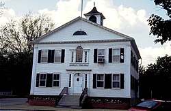
Canterbury is a town in Windham County, Connecticut, United States. The town is part of the Northeastern Connecticut Planning Region. The population was 5,045 at the 2020 census.

<span class="mw-page-title-main">East Brooklyn, Connecticut</span> Census-designated place in Connecticut, United States

East Brooklyn is a census-designated place (CDP) located within the town of Brooklyn in Windham County, Connecticut. It is the portion of the Danielson urban cluster within the town of Brooklyn. The population was 2,205 at the 2020 census. US 6 runs through the town and severs the town.

<span class="mw-page-title-main">Eastford, Connecticut</span> Town in Connecticut, United States

Eastford is a town in Windham County, Connecticut, United States. The town is part of the Northeastern Connecticut Planning Region. The population was 1,649 at the 2020 census.

<span class="mw-page-title-main">Killingly, Connecticut</span> Town in Connecticut, United States

Killingly is a town in Windham County, Connecticut, United States. Killingly is the largest town by population in the Northeastern Connecticut Planning Region. The population was 17,752 at the 2020 census. It consists of the borough of Danielson and the villages of Attawaugan, Ballouville, Dayville, East Killingly, Rogers, and South Killingly.

<span class="mw-page-title-main">Plainfield, Connecticut</span> Town in Connecticut, United States

Plainfield is a town in Windham County, Connecticut, United States. The town is part of the Northeastern Connecticut Planning Region. The population was 14,973 at the 2020 census. The town comprises four villages: Plainfield, Moosup, Wauregan, and Central Village. Each village has their own respective United States Post Office and fire department. The entire town is serviced by the 860 area code.

<span class="mw-page-title-main">Pomfret, Connecticut</span> Town in Connecticut, United States

Pomfret is a town located in Windham County, Connecticut with a population of 4,266 according to the 2020 United States Census. The town is part of the Northeastern Connecticut Planning Region. The town was incorporated in 1713 and was named after Pontefract in West Yorkshire, England. The land on which Pomfret stands today was purchased from Native Americans in 1686 in a deal known as the "Mashmuket Purchase" or "Mashamoquet Purchase".

<span class="mw-page-title-main">Putnam, Connecticut</span> Town in Connecticut, United States

Putnam is a town in Windham County, Connecticut, United States. The town is part of the Northeastern Connecticut Planning Region. The population was 10,214 at the 2020 census.

<span class="mw-page-title-main">Scotland, Connecticut</span> Town in Connecticut, United States

Scotland is a town in Windham County, Connecticut. The town is part of the Northeastern Connecticut Planning Region. As of the 2020 census, the town population was 1,576. Scotland is a predominantly rural town with agriculture as the principal industry. Scotland is the least populated town in Windham County.

<span class="mw-page-title-main">Sterling, Connecticut</span> Town in Connecticut, United States

Sterling is a town in Windham County, Connecticut, United States. The town is part of the Northeastern Connecticut Planning Region. The population was 3,578 at the 2020 census. The rural town is home to two villages: Oneco and Sterling village. Each contains a post office, a church, and a fire station. The town hall and public library are located in Oneco, and the town's one public school is in Sterling village.

<span class="mw-page-title-main">Thompson, Connecticut</span> Town in Connecticut, United States

Thompson is a town in Windham County, Connecticut, United States. The town is part of the Northeastern Connecticut Planning Region. The town was named after Sir Robert Thompson, an English landholder. The population was 9,189 at the 2020 census. Thompson is located in the northeastern corner of the state and is bordered on the north by Webster, Massachusetts and Dudley, Massachusetts, on the east by Douglas, Massachusetts and Burrillville, Rhode Island, on the west by Woodstock, Connecticut, and on the south by Putnam, Connecticut.

<span class="mw-page-title-main">Woodstock, Connecticut</span> Town in Connecticut, United States

Woodstock is a town in Windham County, Connecticut, United States. The town is part of the Northeastern Connecticut Planning Region. The population was 8,221 at the 2020 census.

<span class="mw-page-title-main">Putnam (CDP), Connecticut</span> Census-designated place in Connecticut, United States

Putnam District is a village and census-designated place (CDP) in Windham County, Connecticut, United States. The CDP was formed when the former city of Putnam disincorporated, and it consists of the main town center of the town of Putnam along the Quinebaug River. The village is part of the Northeastern Connecticut Planning Region. The population was 7,214 at the 2010 census.

<span class="mw-page-title-main">Quiet Corner</span> Rural region in Connecticut, US

Northeastern Connecticut, better known as the Quiet Corner, is a historic region of the state of Connecticut, located in the northeastern corner of the state. No official definition exists; the term is generally associated with Windham County, but also sometimes incorporates eastern sections of Tolland County and the northern portion of New London County.

References

  1. "Census - Geography Profile: Brooklyn town, Windham County, Connecticut". United States Census Bureau . Retrieved November 26, 2021.
  2. "National Register Information System". National Register of Historic Places . National Park Service. April 15, 2008.
  3. "Archived copy" (PDF). www.woodstockacademy.org. Archived from the original (PDF) on May 31, 2005. Retrieved January 15, 2022.{{cite web}}: CS1 maint: archived copy as title (link)
  4. "Town of Brooklyn". Archived from the original on October 5, 2006. Retrieved August 31, 2006.
  5. Brooklyn Board of Education. "High School Choice" . Retrieved January 12, 2022.
  6. "Census of Population and Housing". Census.gov. Retrieved June 4, 2015.
  7. "U.S. Census website". United States Census Bureau . Retrieved January 31, 2008.
  8. "Registration and Party Enrollment Statistics as of November 1, 2022" (PDF). Connecticut Secretary of State. Retrieved June 17, 2023.
  9. "General Election Statements of Vote, 1922 – Current". CT Secretary of State. Retrieved December 17, 2020.
  10. "Election Night Reporting". CT Secretary of State. Retrieved December 17, 2020.
  11. [The right of colored people to education, vindicated : letters to Andrew T. Judson, Esq. and others in Canterbury, remonstrating with them on their unjust and unjustifiable procedure relative to Miss Crandall and her school for colored females https://commons.wikimedia.org/wiki/File:The_right_of_colored_people_to_education,_vindicated_-_letters_to_Andrew_T._Judson,_Esq._and_others_in_Canterbury_(IA_ASPC0005189100).pdf] by Samuel J. May, Minister of the 1st Church in Brooklyn
  12. Hubbard, Robert Ernest. Major General Israel Putnam: Hero of the American Revolution, pp. 196-9, McFarland & Company, Inc., Jefferson, North Carolina, 2017. ISBN   978-1-4766-6453-8.
  13. Montaldo, Charles (June 30, 2017). "Serial Killer Michael Ross, The Roadside Strangler". ThoughtCo. Retrieved April 20, 2018.
  14. Climate Summary for Brooklyn, Connecticut