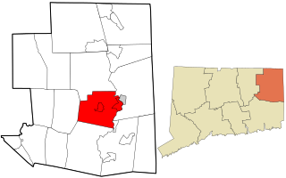
Brooklyn is a town in Windham County, Connecticut, United States. The population was 8,210 at the 2010 census. The town center village is listed by the U.S. Census Bureau as a census-designated place. The district of East Brooklyn is also listed as a separate census-designated place.

Pomfret is a town in Windham County, Connecticut, United States. The population was 4,247 in 2010 according to the United States Census. The land was purchased from Native Americans in 1686 and the town was incorporated in 1713 and named after Pontefract in West Yorkshire, England.

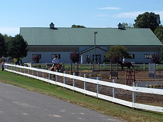
Melrose is a rural village in northeastern East Windsor, Connecticut. Centered at the crossroads of Broad Brook Road and Melrose Road, it was settled in the 1700s and developed as an agrarian village center in the 19th century. A landscape of more than 250 acres (100 ha), including farmland, period farmhouses, ruins of a small distillery, and a district schoolhouse was listed on the National Register of Historic Places in 2010.

Brooklyn Green Historic District is a historic district on Route 169, Route 205, U.S. Route 6, Wolf Den, Brown, Prince Hill, and Hyde Roads in the town of Brooklyn, Connecticut. The district is notable for its Greek Revival, Colonial, and Federal architecture. It was added to the National Register of Historic Places in 1982.

Plainfield Street Historic District is a historic district in Plainfield, Connecticut that encompasses the historic area of Plainfield Village, the town center of Plainfield. The district is linear, being located along Route 12 between Railroad Avenue and Route 14A. It has been the center of the town's civic life since its settlement in the early 18th century, and includes two centuries of architectural styles. The district was listed on the National Register of Historic Places in 1991.
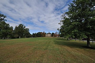
The Woodstock Hill Historic District is a historic district encompassing the historic village center of Woodstock, Connecticut. It is centered on the Woodstock Green, extending south from there toward the junction of Connecticut Route 169 and Plaine Hill Road. Major buildings in the district include the 1821 Congregational Church, the buildings of Woodstock Academy, and Roseland Cottage, a National Historic Landmark that is one of the nation's finest Gothic Revival summer houses. The district was listed on the National Register of Historic Places in 1999.
The West Granby Historic District is a historic district in Granby, Connecticut. It encompasses the historic village of West Granby, which extends along Simsbury Road between Firetown Road and Hartland Road. Although this area was settled in the 18th century, and has a few surviving buildings from that time, its most significant period of development was in the 19th century, when industry came to play a role in the area. The district was listed on the National Register of Historic Places in 1992.

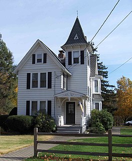
The East Plymouth Historic District is a historic district in the town of Plymouth, Connecticut. It encompasses a small rural village in the northeastern part of the town, whose main focus is the 1792 St. Matthew's Church, one of the oldest surviving Episcopal church buildings in the state. The district runs along East Plymouth Road on either side of its junction with Marsh Road, and includes predominantly Greek Revival residential buildings erected in the early to mid-19th century. The district was listed on the National Register of Historic Places in 1985.
Marion is a neighborhood in the town of Southington in Hartford County, Connecticut, United States. It is generally the area in the vicinity of the intersection of Route 322 and Marion Avenue just north of the Cheshire town line.

The Putnam Farm is a historic farm on Spaulding Road in Brooklyn, Connecticut. The property, now just 9 acres (3.6 ha) of agricultural land with a house on it, was the centerpiece of a vast landholding in the mid-18th century by Major General Israel Putnam, a major colonial-era military figure who saw action in both the French and Indian War and in the American Revolutionary War. The property was listed on the National Register of Historic Places in 1982.

The Calhoun–Ives Historic District, or more formally the Calhoun Street–Ives Road Historic District, is a locally and nationally designated rural agricultural historic district in the town of Washington, Connecticut. It is located a mile north of the village of Washington Depot, Connecticut. It runs along Calhoun Street and Ives Road. It is characterized by modestly scaled 18th and 19th century farmhouses, together with accompanying agricultural outbuildings, farm fields, and fruit orchards, set along roads lined by stone walls. The district was listed on the National Register of Historic Places in 1995.
The East Weatogue Historic District is a 490-acre (200 ha) historic district in the town of Simsbury, Connecticut that was listed on the National Register of Historic Places in 1990. It then included 102 contributing buildings, 10 contributing sites, 11 contributing structures, and one other contributing object. The district encompasses a largely agrarian rural village centered at the junction of Hartford Road and East Weatogue Street, whose early development dates to the late 17th century, with the oldest surviving buildings dating to 1730. Most of the properties in the district are Colonial, Federal, or Greek Revival in character, with only a few later Victorian houses. In the early 20th century Colonial Revival houses sympathetic to the earlier buildings.

The Parker Hill Rural Historic District encompasses a large rural agricultural landscape in eastern Windham and Windsor counties in the US state of Vermont. Roughly centered on Parker Hill Road in northern Rockingham and southern Springfield, the district exhibits a history of 200 years of farming, including a collection of Federal period farm housing. The district was listed on the National Register of Historic Places in 1993.
The Christian Street Rural Historic District encompasses the surviving elements of an early settlement village in the town of Hartford, Vermont. Centered on the junction of Christian Street and Jericho Street in northeastern Hartford, the area includes a modest number of 18th and 19th-century houses, as well as two farms that have been in the same families since the 18th century. The district was listed on the National Register of Historic Places in 2003.
The Jericho Rural Historic District encompasses a rural agricultural landscape of northern Hartford, Vermont, extending slightly into neighboring Norwich. The area covers 774 acres (313 ha) of mainly agricultural and formerly agricultural lands, as well as associated woodlots, and includes nine historically significant farm complexes. It was listed on the National Register of Historic Places in 2001.

The Oxbow Historic District encompasses a well-preserved rural agricultural area on United States Route 5 in northern Newbury, Vermont. It was one of the first areas to be settled in the town, and includes seven agricultural properties, with six farmhouses built before 1835 and a number of surviving 19th-century farm outbuildings. It was listed on the National Register of Historic Places in 1983.

The South Newbury Village Historic District encompasses the surviving elements of a small industrial village in southern Newbury, Vermont. It includes five residences and several outbuildings, most of which are agricultural in character, representing the area's shift in use in the 20th century. The district was listed on the National Register of Historic Places in 1983.

The Hunt Hill Farm is a historic farm property at Upland and Crossman Roads in New Milford, Connecticut. Also known as the Hine–Buckingham Farms, the 137-acre (55 ha) property encompasses two farm properties that remained family-run from the 18th to early 20th centuries. The property includes one 18th and several 19th-century farmhouses and other outbuildings. It was listed on the National Register of Historic Places in 2004. The farmstead is now home to The Silo at Hunt Hill Farm, an arts and culinary organization, while much of the land is held as conservation land by the town.
The Sunny Ridge Historic District encompasses a historic former crossroads village in Washington, Connecticut. It consists of properties abutting the triangular intersection of Sunny Ridge Road, Nettletown Hollow Road, and Old Litchfield Road. This area was in the 18th and 19th centuries a stop on a north-south stagecoach and mail route. It was listed on the National Register of Historic Places in 1995.

The Goodrich Four Corners Historic District encompasses a rural 19th-century village center in rural northern Norwich, Vermont. The village arose in the late 18th century, settled by the son of one of Norwich's early proprietors. The district has well-preserved examples of architecture ranging from the late 18th century to the early 20th century. It was listed on the National Register of Historic Places in 2019.


