Bozrah, Connecticut

Last updated

Bozrah, Connecticut
Town of Bozrah
Town Hall, Bozrah CT.JPG
Town Hall
BozrahCTseal.gif
New London County Connecticut Incorporated and Unincorporated areas Bozrah Highlighted 2010.svg
Bozrah, Connecticut
Bozrah, Connecticut
Bozrah, Connecticut
Coordinates: 41°33′N72°11′W / 41.550°N 72.183°W / 41.550; -72.183
CountryFlag of the United States.svg  United States
U.S. state Flag of Connecticut.svg  Connecticut
County New London
Region Southeastern CT
Incorporated1786
Government
  Type Selectman-town meeting
  First selectmanGlenn Pianka (D)
  SelectmenWilliam Ballinger (D)
Jeremy Tarasevich (R)
Area
  Total20.2 sq mi (52.4 km2)
  Land20.0 sq mi (51.7 km2)
  Water0.3 sq mi (0.7 km2)
Elevation
180 ft (55 m)
Population
 (2020)
  Total2,429
  Density120/sq mi (46/km2)
Time zone UTC-5 (Eastern)
  Summer (DST) UTC-4 (Eastern)
ZIP Code
06334, 06336
Area code(s) 860/959
FIPS code 09-06820
GNIS feature ID0213394
Website www.townofbozrah.org

Bozrah is a town in New London County, Connecticut, United States. The town is part of the Southeastern Connecticut Planning Region. The population was 2,429 at the 2020 census. [1] Bozrah contains three villages: Fitchville, the town center; Leffingwell, a crossroads on Route 82; and Gilman, a mill village along Fitchville Road.

Contents

History

The area that became Bozrah was first settled as part of the original "nine-miles-square" of Norwich as well as part of the Parish of West Farms. The area became its own parish, called "New Concord" or the "Fourth Society of Norwich", in 1737.

A legend about the origin of the town's name

Bozrah is the name of a pastoral community mentioned several times in the Old Testament, sometimes with pleasing connotations, sometimes not. The town name may have resulted from the happy connotations connected with Micah chapter 2, verse 12: "I will surely gather the remnant of Israel; I will put them together as the sheep of Bozrah, as the flock in the midst of their fold; they shall make a great noise by reason of the multitude of men." [2] In Hebrew, the name Bozrah signifies "an enclosure". [3]

According to a persistent legend, the name "Bozrah" was derived from another Biblical text, which came to someone's mind under the particular circumstances surrounding the community's petition to the Connecticut General Assembly for township status. Whether or not the story is true, the informal, early name "New Concord" was dropped when the town was incorporated. [2]

The community, according to the legend, really wanted to call itself "Bath" after the famous spa in England. The local man chosen to carry the parish's request to Hartford had a somewhat eccentric manner of dress, however, and when he appeared before the Legislature he was dressed in loud, parti-colored homespun so odd as to bring to the mind of one amused legislator the query of Isaiah 63:1: "Who is this that cometh from Edom, with dyed garments from Bozrah?" Overcome by the humorous appropriateness of this verse, the Assembly decided to name the town "Bozrah" when it incorporated the place. [2]

Points of interest

Geography

According to the United States Census Bureau, the town has a total area of 20.2 square miles (52.4 km2), of which 20.0 square miles (51.7 km2) is land and 0.27 square miles (0.7 km2), or 1.38%, is water. The town is bordered by the city of Norwich to the east and by the town of Montville to the south, Salem to the southwest, Colchester to the west, Lebanon to the northwest, and Franklin to the north. 529-acre (2.14 km2) Gardner Lake, a popular recreational destination, occupies the southwestern corner of the town and extends into Salem and Montville.

Demographics

Historical population
CensusPop.Note
1820 1,085
1830 1,079−0.6%
1840 1,067−1.1%
1850 867−18.7%
1860 1,21640.3%
1870 984−19.1%
1880 1,15517.4%
1890 1,005−13.0%
1900 799−20.5%
1910 8617.8%
1920 858−0.3%
1930 8590.1%
1940 9045.2%
1950 1,15427.7%
1960 1,59037.8%
1970 2,03628.1%
1980 2,1354.9%
1990 2,2977.6%
2000 2,3572.6%
2010 2,62711.5%
2020 2,429−7.5%
U.S. Decennial Census [4]

As of the census [5] of 2000, there were 2,357 people, 883 households, and 662 families residing in the town. The population density was 118.0 inhabitants per square mile (45.6/km2). There were 917 housing units at an average density of 45.9 per square mile (17.7/km2). The racial makeup of the town was 96.39% White, 0.55% African American, 0.85% Native American, 0.51% Asian, 0.04% Pacific Islander, 0.51% from other races, and 1.15% from two or more races. Hispanic or Latino of any race were 1.78% of the population.

There were 883 households, out of which 32.6% had children under the age of 18 living with them, 62.6% were married couples living together, 7.4% had a female householder with no husband present, and 25.0% were non-families. 19.6% of all households were made up of individuals, and 6.3% had someone living alone who was 65 years of age or older. The average household size was 2.64 and the average family size was 3.03.

In the town, the population was spread out, with 23.5% under the age of 18, 5.9% from 18 to 24, 30.1% from 25 to 44, 26.5% from 45 to 64, and 14.0% who were 65 years of age or older. The median age was 40 years. For every 100 females, there were 100.8 males. For every 100 females age 18 and over, there were 101.6 males.

The median income for a household in the town was $57,059, and the median income for a family was $65,481. Males had a median income of $45,291 versus $27,361 for females. The per capita income for the town was $26,569. About 2.2% of families and 3.7% of the population were below the poverty line, including 5.5% of those under age 18 and 4.7% of those age 65 or over.

As of 2015, the median household income in Bozrah was estimated to be $77,045, compared to $70,331 for the State of Connecticut as a whole. The low income rate, defined as all persons whose annual household income is less than 200 percent of the poverty threshold, was 22%, compared to 30% statewide. [6]

Voter Registration and Party Enrollment as of October 29, 2019 [7]
PartyActive VotersInactive VotersTotal VotersPercentage
Democratic 6082463233.02%
Republican 4031141421.63%
Unaffiliated 7833481742.69%
Minor Parties 492512.66%
Total1,843711,914100%
Presidential Election Results [8] [9]
Year Democratic Republican Third Parties
2020 45.4% 70352.8%8171.8% 28
2016 38.6% 53655.0%7646.4% 89
2012 50.4%64847.0% 6062.6% 34
2008 52.1%72345.6% 6332.3% 32
2004 51.4%72345.9% 6462.7% 38
2000 51.5%68741.9% 5616.6% 89
1996 47.3%57432.7% 39820.0% 243
1992 35.9%47130.7% 40433.4% 439
1988 42.1% 47956.1%6391.8% 21
1984 34.2% 38765.7%7450.1% 2
1980 38.4% 41450.0%54011.6% 126
1976 47.3% 45252.4%5020.3% 3
1972 35.5% 33163.9%5990.6% 6
1968 46.6% 39847.7%4085.7% 49
1964 66.3%54933.7% 2790.00% 0
1960 47.0% 36753.0%4150.00% 0
1956 41.2% 39358.8%6680.00% 0

Education

The town's educational center, Fields Memorial School, serves grades Preschool to 8, and is located in Fitchville. While there is no high school in Bozrah, the town pays tuition for students attending Norwich Free Academy or Lyman Memorial; the state pays for students' tuition at Norwich Technical High School and Waterford High School. [10]

Notable people

Related Research Articles

<span class="mw-page-title-main">New London County, Connecticut</span> County in Connecticut, United States

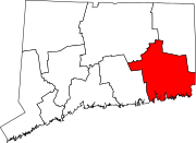
New London County is in the southeastern corner of Connecticut and comprises the Norwich-New London, Connecticut Metropolitan Statistical Area, which is also included in the Hartford-East Hartford, Connecticut Combined Statistical Area. There is no county government and no county seat, as is the case with all eight of Connecticut's counties; towns are responsible for all local government activities, including fire and rescue, snow removal, and schools.

<span class="mw-page-title-main">Huron County, Ohio</span> County in Ohio, United States

Huron County is a county located in the U.S. state of Ohio. As of the 2020 census, the population was 58,565. Its county seat is Norwalk. The county was created in 1809 and later organized in 1815.

<span class="mw-page-title-main">Westbrook, Connecticut</span> Town in Connecticut, United States

Westbrook is a town in Middlesex County, Connecticut, United States. The town is part of the Lower Connecticut River Valley Planning Region. The population was 6,769 at the 2020 census. The town center is classified by the U.S. Census Bureau as a census-designated place (CDP).

<span class="mw-page-title-main">Bethany, Connecticut</span> Town in Connecticut, United States

Bethany is a town in New Haven County, Connecticut, United States. The town is part of the South Central Connecticut Planning Region. The population was 5,297 at the 2020 census.

<span class="mw-page-title-main">Franklin, Connecticut</span> Town in Connecticut, United States

Franklin is a town in New London County, Connecticut, United States. The town is part of the Southeastern Connecticut Planning Region. The population was 1,863 at the 2020 census. The town includes the village of North Franklin.

<span class="mw-page-title-main">Lisbon, Connecticut</span> Town in Connecticut, United States

Lisbon is a town in New London County, Connecticut, United States, 7.3 miles (11.7 km) by road northeast of Norwich. The town is part of the Southeastern Connecticut Planning Region. The population was 4,195 at the 2020 census. The town center is also known as the village of Newent. The town school is Lisbon Central School. Its only postal code, 06351, is Jewett City, Connecticut, which is a village of the town of Griswold, Connecticut and encompasses all of Lisbon and Griswold.

<span class="mw-page-title-main">Montville, Connecticut</span> Town in Connecticut, United States

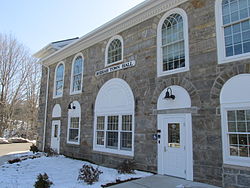
Montville is a town in New London County, Connecticut in the United States. The town is part of the Southeastern Connecticut Planning Region. The population was 18,387 at the 2020 census.

<span class="mw-page-title-main">Preston, Connecticut</span> Town in Connecticut, United States

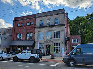
Preston is a town in New London County, Connecticut, United States. The town is part of the Southeastern Connecticut Planning Region. The population was 4,788 at the 2020 census. The town includes the villages of Long Society, Preston City, and Poquetanuck.

<span class="mw-page-title-main">Voluntown, Connecticut</span> Town in Connecticut, United States

Voluntown is a town in New London County, Connecticut, United States. The town is part of the Northeastern Connecticut Planning Region. The population was 2,570 at the 2020 census. Voluntown was part of Windham County from 1726 to 1881, after which it became part of New London County.

<span class="mw-page-title-main">Columbia, Connecticut</span> Town in Connecticut, United States

Columbia is a town in the Capitol Planning Region, Connecticut, United States. The population was 5,272 at the 2020 census. Originally a part of Lebanon, known as the North Society or Lebanon's Crank, Columbia was incorporated in May 1804. The town was named for patriotic reasons after the national symbol "Columbia". Columbia offers pre-kindergarten through 8th grade education in town at Horace W. Porter School, while high school students have a choice of attending four nearby high schools; E. O. Smith High School, Bolton High School (Connecticut), Coventry High School, and Windham Technical High School, part of the Connecticut Technical High School System).

<span class="mw-page-title-main">Somers, Connecticut</span> Town in Connecticut, United States

Somers is a town in Tolland County, Connecticut. The town is part of the Capitol Planning Region. The population was 10,255 at the 2020 census. The town center is listed by the U.S. Census Bureau as a census-designated place (CDP). In 2007, Money Magazine listed Somers 53rd on its "100 Best Places to Live", based on "economic opportunity, good schools, safe streets, things to do and a real sense of community."

<span class="mw-page-title-main">Chaplin, Connecticut</span> Town in Connecticut, United States

Chaplin is a town in Windham County, Connecticut, United States. The town is part of the Northeastern Connecticut Planning Region. The town was named for Deacon Benjamin Chaplin, an early settler. The population was 2,151 at the 2020 census.

<span class="mw-page-title-main">Danielson, Connecticut</span> Borough in Connecticut, United States

Danielson is a borough in the town of Killingly in Windham County, Connecticut, United States. The population was 4,155 at the 2020 census.

<span class="mw-page-title-main">Eastford, Connecticut</span> Town in Connecticut, United States

Eastford is a town in Windham County, Connecticut, United States. The town is part of the Northeastern Connecticut Planning Region. The population was 1,649 at the 2020 census.

<span class="mw-page-title-main">Hampton, Connecticut</span> Town in Connecticut, United States

Hampton is a town in Windham County, Connecticut, United States. The town is part of the Northeastern Connecticut Planning Region. The population was 1,728 at the 2020 census.

<span class="mw-page-title-main">Norwich, Kansas</span> City in Kingman County, Kansas

Norwich is a city in Kingman County, Kansas, United States. As of the 2020 census, the population of the city was 444.

<span class="mw-page-title-main">Montville, Maine</span> Town in the state of Maine, United States

Montville is a town in Waldo County, Maine, United States. The population was 1,020 at the 2020 census.

<span class="mw-page-title-main">Clarksville, New Hampshire</span> Town in New Hampshire, United States

Clarksville is a town in northern Coös County, New Hampshire, United States. The population was 294 at the 2020 census. It is part of the Berlin, NH-VT Micropolitan Statistical Area.

<span class="mw-page-title-main">Clinton, Connecticut</span> Town in Connecticut, United States

Clinton is a town in Middlesex County, Connecticut, United States. The town is part of the Lower Connecticut River Valley Planning Region. The population of the town was 13,185 at the 2020 census. The town center along the shore line was listed as a census-designated place (CDP) by the U.S. Census Bureau in the 2020 census.

<span class="mw-page-title-main">East Hampton, Connecticut</span> Town in Connecticut, United States

East Hampton is a town in Middlesex County, Connecticut, United States. The town is part of the Lower Connecticut River Valley Planning Region. The population was 12,717 at the 2020 census. The town center village is listed as a census-designated place (CDP). East Hampton includes the communities of Cobalt, Middle Haddam, and Lake Pocotopaug.

References

  1. "Census - Geography Profile: Bozrah town, New London County, Connecticut" . Retrieved November 26, 2021.
  2. 1 2 3 Bozrah Web page on Curbstone Press Web site, which itself cites the book Legendary Connecticut, by David E. Philips / ISBN   1-880684-05-5 Web page accessed July 23, 2006
  3. The Connecticut Magazine: An Illustrated Monthly. Connecticut Magazine Company. 1903. p. 331.
  4. "Census of Population and Housing". Census.gov. Retrieved June 4, 2015.
  5. "U.S. Census website". United States Census Bureau . Retrieved January 31, 2008.
  6. "Bozrah Town Profile" . Retrieved June 30, 2017.
  7. "Registration and Party Enrollment Statistics as of October 29, 2019" (PDF). Connecticut Secretary of State. Retrieved February 17, 2020.
  8. "General Election Statements of Vote, 1922 – Current". CT Secretary of State. Retrieved July 11, 2020.
  9. "Election Night Reporting". CT Secretary of State. Retrieved December 16, 2020.
  10. Town of Bozrah Board of Education. "Our Schools" . Retrieved January 12, 2022.