Transportation in New England

Last updated

Transportation in New England encompasses the region's rail and highway networks, seaports, and airports. New England has one of the United States' oldest intercity transportation systems, which remain important to the region's economy. It is also home to the continent's first subway system. The densely populated area has many cities and towns connected by rail and road, and the larger cities each have commercial airports with daily flights to destinations outside of the region.

Contents

Transportation

Public transportation is an essential part of daily life in Greater Boston. Over 1.3 million people ride the MBTA daily, making it one of the busiest transit systems in the U.S. MBTA Boston subway map.png
Public transportation is an essential part of daily life in Greater Boston. Over 1.3 million people ride the MBTA daily, making it one of the busiest transit systems in the U.S.
The MBTA Commuter Rail serves Eastern Massachusetts and parts of Rhode Island radiating from Downtown Boston, with planned service to New Hampshire. The CTrail system operates the Shoreline East and Hartford Lines, covering Coastal Connecticut, Hartford, and Springfield, Massachusetts MBTA Commuter Rail and funding district and CTrail lines.svg
The MBTA Commuter Rail serves Eastern Massachusetts and parts of Rhode Island radiating from Downtown Boston, with planned service to New Hampshire. The CTrail system operates the Shoreline East and Hartford Lines, covering Coastal Connecticut, Hartford, and Springfield, Massachusetts
Amtrak's Northeast Corridor connects southern New England to the Mid-Atlantic. Together, with Acela service, is the busiest rail corridor in the U.S. NEC map.svg
Amtrak's Northeast Corridor connects southern New England to the Mid-Atlantic. Together, with Acela service, is the busiest rail corridor in the U.S.

Rail

The Massachusetts Bay Transportation Authority (MBTA) provides rail and subway service within the Boston metropolitan area, bus service in Greater Boston, and commuter rail service throughout eastern Massachusetts and parts of Rhode Island. The New York City Metropolitan Transportation Authority's Metro-North Railroad provides commuter rail service in southwestern Connecticut, while the Connecticut Department of Transportation operates the Shore Line East commuter rail service along the Connecticut coastline east of New Haven, and the Hartford Line northward to Springfield, Massachusetts. On a trial basis until Fall of 2021, Amtrak is working with CTrail to provide service north of its route from Springfield, through the Valley Flyer route to Greenfield. [3]

Amtrak provides interstate rail service throughout New England. Boston is the northern terminus of the Northeast Corridor line. The Vermonter connects Vermont to Massachusetts and Connecticut, while the Downeaster links Maine to Boston.

Air

The largest and busiest airport in New England is Logan International Airport in Boston, which has many daily flights to domestic and international destinations. Logan has two nearby regional airports considered to be reliever airports, T.F. Green Airport in Warwick, Rhode Island, and Manchester Boston Regional Airport in Manchester, New Hampshire. Bradley International Airport in Windsor Locks, Connecticut, is the region's second busiest airport.

Other commercial airports include Portland International Jetport, Bangor International Airport, Worcester Regional Airport, and Burlington International Airport.

Interstate Highways

Six mainline Interstate highways traverse New England. Interstate highways ending in an even number run east-west; those ending in odd numbers run north-south. At least one serves each state and its respective capital city:
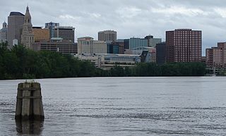
I-84.svg Interstate 84 enters New England at Danbury, Connecticut, and crosses that state to the northeast, connecting the cities of Waterbury and the state capital of Hartford before terminating at a junction with Interstate 90 in Massachusetts.

I-90.svg Interstate 90 carries the Massachusetts Turnpike designation as it crosses the state. I-90 enters Massachusetts at West Stockbridge and travels eastward to its terminus in the state's capital and New England's largest city, Boston. It connects the major cities of Springfield and Worcester and intersects with many of New England's major north-south routes.

I-89.svg Interstate 89 begins at a junction with Interstate 93 just south of New Hampshire's state capital, Concord. It then travels northwesterly until it reaches Lebanon, after which it crosses the Connecticut River and enters Vermont at White River Junction. I-89 continues its northwesterly path to Vermont's state capital of Montpelier; then continues west to Vermont's largest city, Burlington; and finally turns due north along the east shore of Lake Champlain and ends at the international border with Québec, Canada.

I-91.svg Interstate 91 begins in New Haven, Connecticut, at a junction with Interstate 95, running north from there through Connecticut, Massachusetts, and Vermont until it reaches the Canada–US border. I-91 parallels U.S. Route 5 for its entire length, and much of the route also follows the Connecticut River, linking many of the major cities and towns along the river, including state capital Hartford; Springfield, Massachusetts; and Brattleboro, Vermont. I-91 is the only Interstate route within New England that intersects five of the others. Since I-91 runs north-south along the Connecticut River from the Vermont side in lieu of New Hampshire's, the highway does not traverse the states of Rhode Island, New Hampshire, or Maine.

I-93.svg Interstate 93 begins in Canton, Massachusetts, at a junction with Interstate 95, running northwestward from there through the city of Boston. I-93 travels northwesterly from Boston and into New Hampshire, where it serves as the main interstate highway through that state and links many of the larger cities and towns, including Derry; Manchester, the largest city north of Boston; and the state capital, Concord. From there I-93 turns into a generally northerly direction and connects with highways in the state's famed lakes region and then onto its popular White Mountains region, noted for skiing and beautiful autumn foliage. I-93 continues into New Hampshire's far north and eventually crosses the Connecticut River into Vermont and reaches its northern terminus at a junction with Interstate 91 at St. Johnsbury.

I-95.svg Interstate 95, which runs along the East Coast, enters New England at Greenwich, Connecticut, and runs in a generally northeasterly direction along the Atlantic Ocean, eventually heading through Maine's sparsely populated north country to its northern terminus at the Canada–US border with New Brunswick. I-95 serves many of the coastline's cities, including the state capitals of Providence, Rhode Island, and Augusta, Maine, while serving as a partial beltway around Boston. I-95 travels through every New England state except Vermont and is the only two-digit Interstate highway to enter the states of Rhode Island and Maine. It connects most of Connecticut's largest cities except for Hartford and Waterbury and traverses through or near some quaint cities and towns in northern New England including Hampton and Portsmouth, New Hampshire, and Portland and Bangor, Maine.

US Routes

Related Research Articles

Interstate 95 (I-95) is the main north–south Interstate Highway on the East Coast of the United States, running from U.S. Route 1 (US 1) in Miami, Florida to the Houlton–Woodstock Border Crossing between Maine and the Canadian province of New Brunswick. The highway largely parallels the Atlantic coast and US 1, except for the portion between Savannah and Washington and the portion between Portland and Houlton, both of which follow a more direct inland route.

East Coast of the United States Coastline in the United States

The East Coast of the United States, also known as the Eastern Seaboard, the Atlantic Coast, and the Atlantic Seaboard, is the coastline along which the Eastern United States meets the North Atlantic Ocean. Regionally, the term refers to the coastal states and area east of the Appalachian Mountains that have shoreline on the Atlantic Ocean, from north to south, Maine, New Hampshire, Massachusetts, Rhode Island, Connecticut, New York, New Jersey, Delaware, Maryland, Virginia, North Carolina, South Carolina, Georgia, and Florida.

Interstate 91 (I-91) is an Interstate Highway in the New England region of the United States. It provides the primary north–south thoroughfare in the western part of the region. The Interstate generally follows the course of the Connecticut River. Its southern end is in New Haven, Connecticut, at Interstate 95. The northern end of the American-maintained road is in the village of Derby Line, Vermont, at the Canadian border. Past the Derby Line–Rock Island Border Crossing, the road continues as Quebec Autoroute 55. I-91 is the longest of three Interstate highways whose entire route is located within the New England states and is also the only primary (two-digit) Interstate Highway in New England to intersect all five of the other highways that run through the region. The largest cities along its route are New Haven, Connecticut; Hartford, Connecticut; Springfield, Massachusetts; Northampton, Massachusetts; Greenfield, Massachusetts; Brattleboro, Vermont; White River Junction, Vermont; and St. Johnsbury, Vermont in order from south to north.

Interstate 93 (I-93) is an Interstate Highway in the New England states of Massachusetts, New Hampshire, and Vermont in the United States. Spanning approximately 190 miles (310 km) along a north–south axis, it is one of three primary Interstate Highways located entirely within New England, the other two being I-89 and I-91. The largest cities along the route are Boston, Massachusetts, and Manchester, New Hampshire; it also travels through the New Hampshire state capital of Concord.

Interstate 89 (I-89) is an Interstate Highway in the New England region of the United States traveling from Bow, New Hampshire, to the Canadian border between Highgate Springs, Vermont, and Saint-Armand, Quebec. As with all odd-numbered primary interstates, I-89 is signed as a north–south highway. However, it follows a primarily northwest-to-southeast path. The route forms a substantial part of the main connection between the cities of Montreal and Boston. In Quebec the route continues as Quebec Route 133. The eventual completion of Autoroute 35 from Montreal will lead to a non-stop limited access highway route between the two cities, following I-93 south from I-89's terminus. The largest cities directly served by I-89 are Concord, the state capital of New Hampshire, Montpelier, the state capital of Vermont, and Burlington, Vermont. I-89 is one of three main Interstate highways whose route is located entirely within New England, along with I-91 and I-93.

White River Junction, Vermont Census-designated place in Vermont, United States

White River Junction is an unincorporated village and census-designated place (CDP) in the town of Hartford in Windsor County, Vermont, United States. The population was 2,286 at the 2010 census, making it the largest community within the town of Hartford.

Boston and Maine Corporation US railroad

The Boston and Maine Corporation, known as the Boston and Maine Railroad (B&M), was a U.S. Class I railroad in northern New England. It became part of what is now the Pan Am Railways network in 1983.

U.S. Route 5 is a north–south United States highway running through the New England states of Connecticut, Massachusetts, and Vermont. Significant cities along the route include New Haven, Connecticut; Hartford, Connecticut; and Springfield, Massachusetts. From Hartford northward to St. Johnsbury, Vermont, the road closely follows the route of the Connecticut River.

Western Massachusetts Region of Massachusetts, United States

Western Massachusetts is a region in Massachusetts, one of the six U.S. states that make up the New England region of the United States. Western Massachusetts has diverse topography; 22 colleges and universities, with approximately 100,000 students; and such institutions as Tanglewood, the Springfield Armory, and Jacob's Pillow.

Greater Hartford Metropolitan region in the United States

Greater Hartford is a region located in the U.S. state of Connecticut, centered on the state's capital of Hartford. It represents the only combined statistical area in Connecticut defined by a city within the state, being bordered by the Greater Boston region to the northeast and New York metropolitan area to the south and west. Sitting at the southern end of the Metacomet Ridge, its geology is characterized by land of a level grade along the shores of Connecticut River Valley, with finer-grained soil than other regions in the state.

<i>Vermonter</i> (train) Amtrak passenger train in the northeast United States

The Vermonter is a passenger train operated by Amtrak between St. Albans, Vermont, and Washington, D.C., via New York City. It replaced the overnight Montrealer, which terminated in Montreal until 1995. Amtrak receives funding from the states of Connecticut, Massachusetts, and Vermont for Vermonter operations north of New Haven. On March 26, 2020, service north of New Haven was temporarily suspended. On November 30, 2020, service was cut back further from New Haven to New York. Service to St. Albans resumed on July 19, 2021.

New England road marking system

The New England road marking system was a regional system of marked numbered routes in the six-state region of New England in the United States. The routes were marked by a yellow rectangular sign with black numbers and border. Many signs were painted on telephone poles. The routes were approved by the highway departments of the six New England states in April 1922.

Two popular American sports were invented in New England. Basketball was invented by James Naismith, a Canadian, in Springfield, Massachusetts, in 1891. Volleyball was invented by William G. Morgan in Holyoke, Massachusetts, in 1895. Also, the first organized ice hockey game in the United States is widely believed to have been played in Concord, New Hampshire in 1883.

U.S. Route 5 in Connecticut Section of U.S. Highway in Connecticut, United States

U.S. Route 5 (US 5), a north–south U.S. Highway that is generally paralleled by Interstate 91 (I-91), begins at the city of New Haven in Connecticut and heads north through western Massachusetts and eastern Vermont to the international border with Canada. Within Connecticut, US 5 proceeds north from New Haven and passes through Meriden and Hartford towards Springfield, Massachusetts.

U.S. Route 4 (US 4) in the U.S. state of Vermont extends for 66.06 miles (106.31 km) between the New York state line at Fair Haven and the New Hampshire state line at White River Junction. It is one of the main arteries between New York and New Hampshire.

U.S. Route 5 in Vermont

U.S. Route 5 (US 5) is a part of the United States Numbered Highway System that runs from New Haven, Connecticut to the Canada–United States border at Derby Line, Vermont. In Vermont, the road runs south–north from the Massachusetts state line near Guilford to the international border. The 192.316 miles (309.503 km) that lie in Vermont are maintained by the Vermont Agency of Transportation (VTrans) and run largely parallel to Interstate 91. US 5 also follows the path of the Connecticut River from the Massachusetts border to St. Johnsbury, where the river turns northeast while US 5 continues north. The highway serves the major towns of Brattleboro, Hartford, and St. Johnsbury, along with the city of Newport near the Canadian border.

New England Region in the Northeastern United States

New England is a region comprising six states in the Northeastern United States: Connecticut, Maine, Massachusetts, New Hampshire, Rhode Island, and Vermont. It is bordered by the state of New York to the west and by the Canadian provinces of New Brunswick to the northeast and Quebec to the north. The Atlantic Ocean is to the east and southeast, and Long Island Sound is to the southwest. Boston is New England's largest city, as well as the capital of Massachusetts. Greater Boston is the largest metropolitan area, with nearly a third of New England's population; this area includes Worcester, Massachusetts, Manchester, New Hampshire, and Providence, Rhode Island.

The Connecticut River Railroad was a railroad located along the Connecticut River in western Massachusetts, formed in 1845 from the merger of two unfinished railroads. Its main line from Springfield to East Northfield, Massachusetts, opened in stages between 1845 and 1849. It built several branches and over the years acquired additional lines in Vermont. The railroad was acquired by the Boston and Maine Railroad in 1893.

<i>Ambassador</i> (B&M train)

The Ambassador was a passenger train that traveled from Boston, Massachusetts and New York City, New York to Montreal, Quebec. The train was jointly operated by the New York, New Haven and Hartford Railroad, Boston and Maine Railroad, the Central Vermont Railroad, and the Canadian National Railway. Beginning service on April 26, 1926, the Ambassador operated on a daytime schedule between Boston and Montreal, with coach, dining, and parlor cars in the consist. The route going north of White River Junction went northwest, through Montpelier and Essex Junction toward Montreal. There were also through cars to New York City offered until the mid-1950s, split from the Ambassador's consist in White River Junction, Vermont and added to the Connecticut Yankee train for points south. In its route from Boston's North Station it passed through Manchester (Union Station, Concord and Franklin in New Hampshire.

References

  1. "Haverhill chamber chief supports train stop in Plaistow". Eagletribune.com. Archived from the original on January 22, 2013. Retrieved November 11, 2012.
  2. "Plaistow officials hopeful MBTA considers rail extension". Eagletribune.com. March 9, 2008. Archived from the original on July 29, 2012. Retrieved November 11, 2012.
  3. "Valley Flyer". Trains in the Valley. Archived from the original on August 30, 2019.