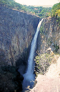
The Kalambo Falls on the Kalambo River is a 772-foot (235 m) single-drop waterfall on the border of Zambia and Tanzania at the southeast end of Lake Tanganyika. The falls are some of the tallest uninterrupted falls in Africa. Downstream of the falls is the Kalambo Gorge, which has a width of about 1 km and a depth of up to 300 m, running for about 5 km before opening out into the Lake Tanganyika rift valley.
The Calico Early Man Site is an archaeological site in an ancient Pleistocene lake located near Barstow in San Bernardino County in the central Mojave Desert of southern California. This site is on and in late middle-Pleistocene fanglomerates known variously as the Calico Hills, the Yermo Hills, or the Yermo formation. Holocene evidence includes petroglyphs and trail segments that are probably related to outcrops of local high-quality siliceous rock.
In the sequence of cultural stages first proposed for the archaeology of the Americas by Gordon Willey and Philip Phillips in 1958, the Lithic stage was the earliest period of human occupation in the Americas, as post-glacial hunters and collectors spread through the Americas. The stage derived its name from the first appearance of Lithic flaked stone tools. The term Paleo-Indian is an alternative, generally indicating much the same period.
The Late Glacial Interstadial (LGI) c.14,670 to c.12,890 BP represents the first pronounced warming since the end of the Last Glacial Maximum (LGM). Human populations, which had previously forced into refuge areas, gradually begin to repopulate the Northern Hemisphere's Eurasian landmass and eventually populate North America via Beringia for the first time.

Axlor is a prehistoric archeological site in the village of Dima in Biscay in the Autonomous Basque Community of Spain, dating from the Middle Paleolithic or Mousterian period.
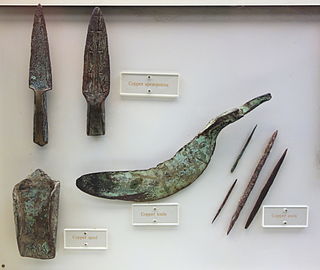
Old Copper Complex is a term used for ancient Native North American societies known to have been heavily involved in the utilization of copper for weaponry and tools. The evidence of smelting or alloying that has been found is subject to some dispute and a common assumption by archaeologists is that objects were cold-worked into shape. Artifacts from some of these sites have been dated from 4000 to 1000 BCE. Furthermore, some archaeologists find artifactual and structural evidence of casting by Hopewellian and Mississippian peoples to be demonstrated in the archaeological record.

The Eva site (40BN12) is a prehistoric Native American site in Benton County, Tennessee, in the Southeastern United States. Located along an ancient channel of the Tennessee River, the Eva site saw extensive periods of occupation during the Middle and Late Archaic period. The site's well-defined midden layers helped investigators identify three distinct Archaic cultures, the oldest of which was first identified at Eva and is still known as the "Eva culture" or the "Eva phase."

The Manis Mastodon site is a 2-acre (1 ha) archaeological site on the Olympic Peninsula near Sequim, Washington, United States. During the dig, the remains of an American mastodon was recovered which had a 13,800 year old projectile made of the bone from a different mastodon embedded in its rib. The site was placed on the National Register of Historic Places in 1978.
J&J Hunt Site (8JE740) is an inundated prehistoric archaeological site located 6 km off the coast of northwestern Florida. The site which was discovered in 1989 is located in 3.7 to 4.6 m of salt water in the Gulf of Mexico along the PaleoAucilla River. In prehistory the site had at least two different occupations: a Late Paleoindian-Early Archaic and Middle Archaic. The J&J Hunt site was a major focus of the PaleoAucilla Prehistory Project conducted by Dr. Michael K. Faught.

The archaeology of Iowa is the study of the buried remains of human culture within the U.S. state of Iowa from the earliest prehistoric through the late historic periods. When the American Indians first arrived in what is now Iowa more than 13,000 years ago, they were hunters and gatherers living in a Pleistocene glacial landscape. By the time European explorers visited Iowa, American Indians were largely settled farmers with complex economic, social, and political systems. This transformation happened gradually. During the Archaic period American Indians adapted to local environments and ecosystems, slowly becoming more sedentary as populations increased. More than 3,000 years ago, during the Late Archaic period, American Indians in Iowa began utilizing domesticated plants. The subsequent Woodland period saw an increase on the reliance on agriculture and social complexity, with increased use of mounds, ceramics, and specialized subsistence. During the Late Prehistoric period increased use of maize and social changes led to social flourishing and nucleated settlements. The arrival of European trade goods and diseases in the Protohistoric period led to dramatic population shifts and economic and social upheaval, with the arrival of new tribes and early European explorers and traders. During the Historical period European traders and American Indians in Iowa gave way to American settlers and Iowa was transformed into an agricultural state.

The eastern savannas of the United States covered large portions of the southeast side of the continent until the early 20th century. These were in a fire ecology of open grassland and forests with low ground cover of herbs and grasses.

Grotte du Vallonnet is an archaeological site located near Roquebrune-Cap-Martin, between Monaco and Menton, in France, that was first discovered in 1958. Stone tools found at the site have been dated to between 1 and 1.05 million years old, making it one of the earliest sites of human settlement known in Europe.

Franktown Cave is located 25 miles south of Denver, Colorado on the north edge of the Palmer Divide. It is the largest rock shelter documented on the Palmer Divide, which contains artifacts from many prehistoric cultures. Prehistoric hunter-gatherers occupied Franktown Cave intermittently for 8000 years beginning about 6400 B.C. The site held remarkable lithic and ceramic artifacts, but it is better known for its perishable artifacts, including animal hides, wood, fiber and corn. Material goods were produced for their comfort, task-simplification and religious celebration. There is evidence of the site being a campsite or dwelling as recent as AD 1725.
Sisyphus Shelter is an archaeological site that was uncovered in Colorado when the Colorado Department of Highways was working on I-70. The excavation of this site became a joint project between the Colorado Department of Highways and the Bureau of Land Management. Fieldwork on the site was completed in 1980. Archaeologists John Gooding and Wm. Lane Shields as well as many others completed the excavation and prepared a comprehensive site report. Over the course of the fieldwork on Sisyphus Shelter, twenty-six features of human origin were discovered as well as numerous stone artifacts and two perishable items. The artifacts appeared to be all Late Archaic in origin. Dating indicated a range of occupations from modern times to 4400 B.P. being the oldest sample. Gooding and Shields (1985) suggest that the occupations of the shelter were not consistent and affected by seasonal changes.
Hidden Cave is an archaeological cave site located in the Great Basin near Fallon, Nevada, United States. It got its name from Mark Harrington, who first excavated the cave and had a hard time finding the entrance, who said at the time, "This is one hidden cave!" It was excavated originally in the 1930s by Harrington and then excavated twice more before being returned to for the final time in 1978 by David Hurst Thomas for a more in depth excavation. The site dates back to the early Desert Archaic Culture from c. 4000 to 2000 years ago. Thousands of Archaic artifacts have been found here, and the site "provides important, if unusual clues about Desert Archaic lifeways". Hidden Cave was not lived in, but used as storage site for goods and tools for the 2000 years of its survival.

Ifri Oudadane is an archaeological site in the northeastern Rif region of Morocco. It is located on the southwestern coast of the Cape Three Forks on the Mediterranean Sea, and is one of the most important sites in the northwestern Maghreb region of Africa. Discovered during road construction, the site consists of a fairly large rock shelter above the modern coastline, the site has been excavated since 2006 by a team of Moroccan and German archaeologists. Although much is known about the transition of humans from hunter gatherer groups to food production in Europe and the Middle East, much of North Africa has not been researched. Ifri Oudadane is one of the first of such sites in North Africa. Dated to between 11000 and 5700 years BP, the site contains evidence that documents the shift of local inhabitants from hunter-gatherer groups to food producers. Such elements of change found at Ifri Oudadane include evidence of animal husbandry, domestication of legumes, and decoration of pottery. The site is known to contain the earliest dated crop in Northern Africa, a lentil.
At the end of the last Ice Age, Newfoundland and Labrador were covered in thick ice sheets. The province has had a continuous human presence for approximately 5000 years. Although Paleo-Indians are known from Nova Scotia dating back 11,000 years, no sites have been found north of the St. Lawrence. The oldest traces of human activity, in the form of quartz and quartzite knives, were discovered in 1974 in southern Labrador, but some archaeologists have speculated that a human presence may go back as much as 9000 years. Highly acidic soils have destroyed much of the bone and other organic material left behind by early humans and thus complicates archaeological research.
Humans have been present in the Canadian Maritime provinces for 10,600 years. In spite of being the first part of Canada to be settled by Europeans, research into the prehistory of the Maritimes did not become extensive until 1969. By the early 1980s, several full-time archaeologists focused on the region.
The Archaic period, also known as the preceramic period, is a period in Mesoamerican chronology that begins around 8000 BCE and ends around 2000 BCE and is generally divided into Early, Middle, and Late Archaic periods. The period is preceded by the Paleoindian period and followed by the Preclassic period. Scholars have found it difficult to determine exactly when the Paleoindian period ends and the Archaic begins, but it is generally linked with changing climate associated with the transition from the Pleistocene to the Holocene epochs, and absence of extinct Pleistocene animals. It is also generally unclear when the Archaic period ends and the Preclassic period begins, though the appearance of pottery, large-scale agriculture, and villages signal the transition.
The Annasnappet Pond Site was excavated, beginning in 1978 by the Public Archaeology Lab, when the Massachusetts Highway Department began the process of relocating Route 44 through Plympton, Plymouth, Carver and Kingston. Because the department was using federal funds, it was required to do an archaeological survey of the area, which revealed potential for sites at Annasnappet Pond in Carver, Massachusetts.