Norfolk (CDP), Connecticut

Last updated
Norfolk, Connecticut
Soldiers Monument, Norfolk CT.jpg
Soldiers' Monument
Litchfield County Connecticut Incorporated and Unincorporated areas Norfolk (CDP) Highlighted 2010.svg
Location in Litchfield County, Connecticut
Coordinates: 41°59′22″N73°11′58″W / 41.98944°N 73.19944°W / 41.98944; -73.19944
State Connecticut
County Litchfield
Town Norfolk
Area
  Total0.93 sq mi (2.41 km2)
  Land0.93 sq mi (2.41 km2)
  Water0.0 sq mi (0.0 km2)
Elevation
1,265 ft (386 m)
Population
 (2010)
  Total553
  Density595/sq mi (229.6/km2)
ZIP Code
06058
FIPS code 09-54300
GNIS feature ID209306

Norfolk is a census-designated place (CDP) in Litchfield County, Connecticut, United States. It is the central village within the town of Norfolk. As of the 2010 census, the population of the CDP was 553, [1] out of 1,709 in the entire town.

Contents

Geography

Norfolk is in northwestern Connecticut, in the Litchfield Hills. It includes the Norfolk Historic District, which covers the historic center of the village, but also extends west to include Old Colony Road, Blackberry Street, and Valley View Road, north to include Shepard Road, east to include Laurel Way and Beacon Lane, and south to include Highfield Road, Grant Street, and Battell Road. [2] It is bordered to the northwest by Haystack Mountain State Park.

U.S. Route 44 passes through the center of the community, leading west 7 miles (11 km) to Canaan village and southeast 10 miles (16 km) to Winsted. Connecticut Route 272 joins US 44 through the center of Norfolk but leads south 15 miles (24 km) to Torrington and north 4 miles (6 km) to the Massachusetts border.

According to the U.S. Census Bureau, the Norfolk CDP has a total area of 0.93 square miles (2.4 km2), all land. [1] Wood Creek, Norfolk Brook, and Spaulding Brook run along the edges of the CDP, joining in the western part to form the Blackberry River, a west-flowing tributary of the Housatonic River.

Demographics

As of the census of 2010, there were 553 people, 249 households, and 152 families residing in the CDP. The population density was 595 inhabitants per square mile (230/km2). There were 315 housing units, of which 66, or 21.0%, were vacant. 34 of the vacant units were for seasonal or recreational use. The racial makeup of the CDP was 95.3% White, 1.8% African American, 0.4% Native American, 0.4% Asian, 0.9% some other race, and 1.3% from two or more races. Hispanic or Latino of any race were 0.9% of the population. [3]

Of the 249 households in the community, 25.3% had children under the age of 18 living with them, 46.6% were headed by married couples living together, 10.4% had a female householder with no husband present, and 39.0% were non-families. 32.1% of all households were made up of individuals, and 18.1% were someone living alone who was 65 years of age or older. The average household size was 2.21, and the average family size was 2.72. [3]

19.5% of the CDP population were under the age of 18, 7.9% were from 18 to 24, 14.6% were from 25 to 44, 35.4% were from 45 to 64, and 22.6% were 65 years of age or older. The median age was 49.8 years. For every 100 females, there were 90.0 males. For every 100 females age 18 and over, there were 90.2 males. [3]

For the period 2013-17, the estimated median income for a household in the CDP was $58,125, and the median income for a family was $85,000. The per capita income for the CDP was $41,262. 0% of families and 6.6% of the total population were living below the poverty line, including 0% of people under 18 and 15.9% of those over 64. [4]

Related Research Articles

<span class="mw-page-title-main">Bethlehem, Connecticut</span> Town in Connecticut, United States

Bethlehem is a town in Litchfield County, Connecticut, United States. The population was 3,385 at the 2020 census, down from 3,607 at the 2010 census. The town is part of the Naugatuck Valley Planning Region. The town center is a historic district and a census-designated place (CDP).

<span class="mw-page-title-main">Harwinton, Connecticut</span> Town in Connecticut, United States

Harwinton is a town in Litchfield County, Connecticut, United States. The population was 5,484 at the 2020 census. The town is part of the Northwest Hills Planning Region. The high school is Lewis S. Mills.

<span class="mw-page-title-main">New Hartford, Connecticut</span> Town in Connecticut, United States

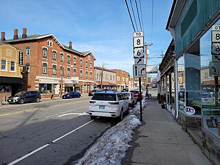
New Hartford is a town in Litchfield County, Connecticut, United States. The population was 6,658 at the 2020 census. The town is part of the Northwest Hills Planning Region. The town center is defined by the U.S. Census Bureau as the New Hartford Center census-designated place (CDP). The town is mainly a rural community consisting of farms, homes, and parks. Brodie Park and Ski Sundown are located in New Hartford.

<span class="mw-page-title-main">Norfolk, Connecticut</span> Town in Connecticut, United States

Norfolk is a town in Litchfield County, Connecticut, United States. The population was 1,588 at the 2020 census. The town is part of the Northwest Hills Planning Region. The urban center of the town is the Norfolk census-designated place, with a population of 553 at the 2010 census.

<span class="mw-page-title-main">Northwest Harwinton, Connecticut</span> Census-designated place in Connecticut, United States

Northwest Harwinton is a census-designated place (CDP) in the town of Harwinton in Litchfield County, Connecticut, United States. The population was 3,158 at the 2020 census, out of 5,484 in the entire town. The CDP contains the town center.

<span class="mw-page-title-main">Oakville, Connecticut</span> Census-designated place in Connecticut, United States

Oakville is a census-designated place (CDP) and neighborhood section of Watertown, in Litchfield County, Connecticut, United States. The population was 9,047 as of the 2010 census. It is the most populous community in Watertown, with more than twice as many people as the center village of Watertown. The ZIP code for Oakville is 06779.

<span class="mw-page-title-main">Terryville, Connecticut</span> Census-designated place in Plymouth, Connecticut, US

Terryville is a census-designated place (CDP) in Litchfield County, Connecticut, United States, and is the largest village within the town of Plymouth. In the 2010 census, Terryville had a population of 5,387, out of 12,243 in the entire town of Plymouth. The village is named for Eli Terry Jr., the son of the well-known clockmaker Eli Terry Sr. Terryville is also home to the Lock Museum of America. There is a water wheel located in downtown Terryville that is dedicated to the son of Eli Terry Sr.

<span class="mw-page-title-main">Thomaston, Connecticut</span> Town in Connecticut, United States

Thomaston is a town in Litchfield County, Connecticut, United States. The town is part of the Naugatuck Valley Planning Region. The population was 7,442 at the 2020 census. The urban center of the town is the Thomaston census-designated place, with a population of 1,928 at the 2020 census.

<span class="mw-page-title-main">Ridgefield (CDP), Connecticut</span> Census-designated place in Connecticut, United States

Ridgefield is a census-designated place (CDP) in Fairfield County, Connecticut, United States. It consists of the primary central village in the town of Ridgefield and surrounding residential areas. As of the 2020 census, the population of the CDP was 7,596, out of 25,053 in the entire town.

<span class="mw-page-title-main">New Milford (CDP), Connecticut</span> Census-designated place in Connecticut, United States

Downtown New Milford is a district/census-designated place (CDP) in Litchfield County, Connecticut, United States. It comprises the main population center within the town of New Milford. As of the 2010 census, the population of Downtown New Milford was 6,523, out of 28,142 in the entire town of New Milford.

<span class="mw-page-title-main">Bethlehem Village, Connecticut</span> Census-designated place in Connecticut, United States

Bethlehem Village is a census-designated place (CDP) within the town of Bethlehem in Litchfield County, Connecticut, United States. The CDP includes the Bethlehem Green Historic District at the town center, as well as surrounding residential and rural land. As of the 2010 census, the CDP had a population of 2,021, out of a population of 3,607 for the entire town of Bethlehem.

<span class="mw-page-title-main">New Hartford Center, Connecticut</span> Census-designated place in Connecticut, United States

New Hartford Center is a census-designated place (CDP) in Litchfield County, Connecticut, United States. It comprises the village of New Hartford, the adjacent Pine Meadow Historic District, and some surrounding forest land, all within the town of New Hartford. As of the 2010 census, the population of New Hartford Center was 1,385, out of 6,970 in the entire town of New Hartford.

<span class="mw-page-title-main">Woodbury Center, Connecticut</span> Census-designated place in Connecticut, United States

Woodbury Center is a census-designated place (CDP) in Litchfield County, Connecticut, United States. It comprises the twin villages of Woodbury and North Woodbury and surrounding residential land in the town of Woodbury. As of the 2010 census, the population of the CDP was 1,294, out of 9,975 in the entire town.

<span class="mw-page-title-main">Canaan, Connecticut</span> Town in Connecticut, United States

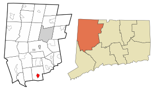
Canaan is a town in Litchfield County, Connecticut, United States. The population was 1,080 at the 2020 census, down from 1,234 at the 2010 census. The town is part of the Northwest Hills Planning Region. The town of Canaan is often referred to locally by the name of its principal settlement, Falls Village.

<span class="mw-page-title-main">Canaan (village), Connecticut</span> United States historic place

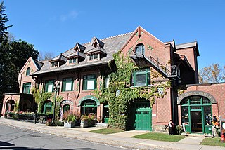
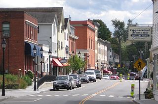
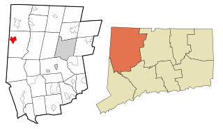
Canaan is a village and census-designated place (CDP) within the town of North Canaan in Litchfield County, Connecticut, United States. Formerly known as Canaan Depot, the village is more commonly known as Canaan Village to distinguish it from the town of Canaan located to the south of North Canaan. The Canaan Village Historic District is listed on the National Register of Historic Places. As of the 2010 census, the CDP had a population of 1,212, out of a total population of 3,315 in the town of North Canaan.

<span class="mw-page-title-main">Greenwich (CDP), Connecticut</span> Census-designated place in Connecticut, United States

Greenwich is a census-designated place (CDP) in Fairfield County, Connecticut, United States. It is one of several CDPs within the town of Greenwich and corresponds to the historic municipal center of the town and surrounding residential and commercial areas. As of the 2010 census, the population of the Greenwich CDP was 12,942, out of 61,171 in the entire town.

<span class="mw-page-title-main">Manchester (CDP), Connecticut</span> Census-designated place in Connecticut, United States

Manchester is a census-designated place (CDP) in Hartford County, Connecticut, United States, comprising the urban center of the town of Manchester. As of the 2010 census, the population of the CDP was 30,577, out of 58,241 in the entire town.

<span class="mw-page-title-main">Watertown (CDP), Connecticut</span> Census-designated place in Connecticut, United States

Watertown is a census-designated place (CDP) in Litchfield County, Connecticut, United States. It comprises the central village of the town of Watertown. As of the 2010 census, the population of the CDP was 3,574, out of 22,514 in the entire town. As of the 2020 Census, the population was 22,105.

<span class="mw-page-title-main">Sharon (CDP), Connecticut</span> Census-designated place in Connecticut, United States

Sharon is a census-designated place (CDP) in Litchfield County, Connecticut, United States. It is the primary village within the town of Sharon. As of the 2010 census, the population of the CDP was 729, out of 2,782 in the entire town.

<span class="mw-page-title-main">Thomaston (CDP), Connecticut</span> Census-designated place in Connecticut, United States

Thomaston is a census-designated place (CDP) in Litchfield County, Connecticut, United States. It comprises the downtown portion of the town of Thomaston. As of the 2010 census, the population of the CDP was 1,910, out of 7,887 in the entire town.

References

  1. 1 2 "Geographic Identifiers: 2010 Census Summary File 1 (G001), Norfolk CDP, Connecticut". American FactFinder. U.S. Census Bureau. Archived from the original on February 13, 2020. Retrieved October 25, 2019.
  2. "TIGERweb: Norfolk, Connecticut". Geography Division, U.S. Census Bureau. Retrieved October 25, 2019.
  3. 1 2 3 "Profile of General Population and Housing Characteristics: 2010 Census Summary File 1 (DP-1), Norfolk CDP, Connecticut". American FactFinder. U.S. Census Bureau. Archived from the original on February 13, 2020. Retrieved October 25, 2019.
  4. "Selected Economic Characteristics: 2013-2017 American Community Survey 5-Year Estimates (DP03), Norfolk CDP, Connecticut". American FactFinder. U.S. Census Bureau. Archived from the original on February 13, 2020. Retrieved October 25, 2019.