Southington is a town in Hartford County, Connecticut, United States. The town is part of the Capitol Planning Region. As of the 2020 United States Census, it had a population of 43,501. Southington contains the villages of Marion, Milldale, and Plantsville.

Wolcott is a town in New Haven County, Connecticut, United States. The town is part of the Naugatuck Valley Planning Region. It is primarily residential, with a population of 16,142 as of the 2020 United States Census.
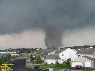
The Wisconsin tornado outbreak of 2005 was an outbreak of tornadoes that occurred primarily in southern Wisconsin on August 18, 2005. A system of storms unleashed a total of 28 tornadoes, 27 of which were confirmed in southern Wisconsin, and 1 confirmed in Minnesota. This outbreak set a new record for the most tornadoes observed in the state in a single day, breaking the previous record of 24 tornadoes set on May 8, 1988. The system generating the Stoughton tornado was also accompanied by many reports of severe winds and hail throughout the region. The Stoughton tornado was documented on an episode of The Weather Channel's Storm Stories.

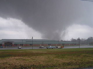
The Tornado outbreak sequence of March 9–13, 2006 was an early season and long lasting tornado outbreak sequence in the central United States that started on the morning of March 9 and continued for over four days until the evening of March 13. The outbreak produced 99 confirmed tornadoes, which killed a total of 10 people. The Storm Prediction Center (SPC) issued multiple elevated outlook throughout the sequence, including a rare high risk for March 12, which would end up being the most intense day of the outbreak, producing 62 in total. 11 F3 tornadoes were tallied, and a violent F4 tornado touched down in Monroe County, Missouri, becoming the strongest of the outbreak. Multiple tornado emergencies were issued for tornadoes throughout the outbreak as well. An intense F3 tornado that affected the towns of Renick and Maddison in Missouri killed 4 people and injured dozens others, becoming the deadliest of the sequence. Multiple of the tornadoes were long-tracked in nature, with 6 of them having paths exceeding 30 miles (48 km). One particular supercell thunderstorm during the outbreak persisted for many hours and progressed in excess of 800 miles (1,300 km) through Oklahoma, Kansas, Missouri, Illinois, Indiana, and extreme southern Michigan.
This page documents notable tornadoes and tornado outbreaks worldwide in 2005. Strong and destructive tornadoes form most frequently in the United States, Bangladesh, Argentina, Brazil and Eastern India, but they can occur almost anywhere under the right conditions. Tornadoes also develop occasionally in southern Canada during the Northern Hemisphere's summer and somewhat regularly at other times of the year across Europe, Asia, and Australia. Tornadic events are often accompanied with other forms of severe weather, including strong thunderstorms, strong winds, and hail.
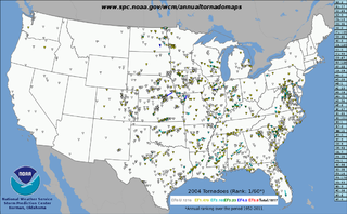
This page documents notable tornadoes and tornado outbreaks worldwide in 2004. Strong and destructive tornadoes form most frequently in the United States, Bangladesh, and Eastern India, but they can occur almost anywhere under the right conditions. Tornadoes also develop occasionally in southern Canada during the Northern Hemisphere's summer and somewhat regularly at other times of the year across Europe, Asia, and Australia. Tornadic events are often accompanied with other forms of severe weather, including strong thunderstorms, strong winds, and hail.
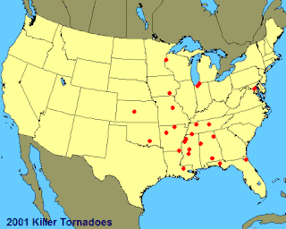
This page documents notable tornadoes and tornado outbreaks worldwide in 2001. Strong and destructive tornadoes form most frequently in the United States, Bangladesh, and Eastern India, but they can occur almost anywhere under the right conditions. Tornadoes also develop occasionally in southern Canada during the Northern Hemisphere's summer and somewhat regularly at other times of the year across Europe, Asia, and Australia. Tornadic events are often accompanied with other forms of severe weather, including strong thunderstorms, strong winds, and hail.
Waterville is a neighborhood of the city of Waterbury, Connecticut. It was formerly known as Pine Hole and Haydensville. It has been home to industrial and manufacturing facilities from the 1960s onward. The ethnic makeup of Waterville consists of Italian, Irish, French and Latin American. This section of Waterbury contains two parks and the main office of the city's Department of Transportation.
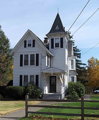
Marion is a neighborhood in the town of Southington, Connecticut, United States. It is generally the area in the vicinity of the intersection of Route 322 and Marion Avenue, just north of the Cheshire town line.
On June 18, 2001, a small, but fatal tornado outbreak occurred across the Upper Midwest as well as Florida. The outbreak spawned a long-tracked F3 tornado that killed three people, and caused approximately US$10 million in damage. The tornado struck Siren, Wisconsin, a small village whose only siren was malfunctioning when the tornado moved through. Other less damaging tornadoes were confirmed in Florida, Iowa, Minnesota and Nebraska. Following the outbreak, areas affected by the Wisconsin tornado received financial assistance from local and federal authorities.
Bunker Hill is a neighborhood of the city of Waterbury, Connecticut. Though part of the city of Waterbury, it has its own identity with its own commercial center, schools, parks and gatherings. It can be self-sustaining, containing many attributes of municipalities throughout the state. Like the other sections/neighborhoods of Waterbury, its distinctive character, shaped by the history and geography of the city, has led residents to form an unusual loyalty to their neighborhood.

This page documents the tornadoes and tornado outbreaks of 1962, primarily in the United States. Most tornadoes form in the U.S., although tornadoes events can take place internationally. Tornado statistics for older years like this often appear significantly lower than modern years due to fewer reports or confirmed tornadoes.

This page documents the tornadoes and tornado outbreaks of 1958, primarily in the United States. Most tornadoes form in the U.S., although some events may take place internationally. Tornado statistics for older years like this often appear significantly lower than modern years due to fewer reports or confirmed tornadoes.

This page documents the tornadoes and tornado outbreaks of 1954, primarily in the United States. Most tornadoes form in the U.S., although some events may take place internationally. Tornado statistics for older years like this often appear significantly lower than modern years due to fewer reports or confirmed tornadoes.
This page documents the tornadoes and tornado outbreaks of 1951, primarily in the United States. Most tornadoes form in the U.S., although some events may take place internationally. Tornado statistics for older years like this often appear significantly lower than modern years due to fewer reports or confirmed tornadoes.
This page documents the tornadoes and tornado outbreaks of 1950, primarily in the United States. Most tornadoes form in the U.S., although some events may take place internationally.

The first six days of December 1953 produced a destructive and deadly tornado outbreak sequence across the Southern United States. There were 19 confirmed tornadoes, including a violent F4 tornado that hit the northwest side of Alexandria, Louisiana and even more violent F5 tornado that hit Vicksburg, Mississippi. In all, the tornadoes killed 49 people, injured 404 others, and caused $45,709 million in damage. The death toll made this deadliest December tornado outbreak ever recorded and it would not be surpassed until 2021. This was also the last of the series of deadly and catastrophic tornado outbreaks to strike the US in 1953.
A destructive and deadly tornado outbreak tore through Eastern Alabama and Western Georgia during the afternoon of December 5, 1954. A total of 14 tornadoes were confirmed, 10 of which were significant (F2+), including one that hit Metro Atlanta. Two people were killed, 125 others were injured, and damages total $2.710 million.