Glastonbury Center, Connecticut

Last updated

Glastonbury Center, Connecticut
Welles Chapman Tavern, Glastonbury CT.jpg
Welles Chapman Tavern
USA Connecticut location map.svg
Red pog.svg
Glastonbury Center
Usa edcp location map.svg
Red pog.svg
Glastonbury Center
Coordinates: 41°42′44″N72°36′31″W / 41.71222°N 72.60861°W / 41.71222; -72.60861
CountryUnited States
State Connecticut
County Hartford
Town Glastonbury
Area
  Total4.9 sq mi (12.7 km2)
  Land4.7 sq mi (12.3 km2)
  Water0.2 sq mi (0.4 km2)
Elevation
50 ft (20 m)
Population
 (2010)
  Total7,387
  Density1,500/sq mi (580/km2)
Time zone UTC-5 (Eastern)
  Summer (DST) UTC-4 (Eastern)
ZIP code
06033
Area code 860
FIPS code 09-31270
GNIS feature ID2377822

Glastonbury Center is a census-designated place (CDP) that constitutes the densely populated center of the town of Glastonbury in Hartford County, Connecticut, United States. The population was 7,387 at the 2010 census, [1] out of a total town population of 34,427.

Contents

Geography

Glastonbury Center is located in the northwestern part of the town of Glastonbury, near the east bank of the Connecticut River, 7 miles (11 km) southeast of Hartford, the state capital. The Route 17 and Route 2 expressways merge at the northeastern edge of the CDP, bypassing the center of the village.

According to the United States Census Bureau, the Glastonbury Center CDP has a total area of 4.9 square miles (12.7 km2), of which 4.7 square miles (12.3 km2) is land and 0.15 square miles (0.4 km2), or 3.30%, is water. [1]

Demographics

As of the census of 2000, there were 7,157 people, 3,257 households, and 1,866 families residing in the CDP. The population density was 1,500.0 inhabitants per square mile (579.2/km2). There were 3,405 housing units at an average density of 713.6 per square mile (275.5/km2). The racial makeup of the CDP was 95.49% White, 0.88% African American, 0.21% Native American, 1.80% Asian, 0.94% from other races, and 0.68% from two or more races. Hispanic or Latino of any race were 2.57% of the population.

There were 3,257 households, out of which 24.2% had children under the age of 18 living with them, 47.6% were married couples living together, 7.8% had a female householder with no husband present, and 42.7% were non-families. 36.8% of all households were made up of individuals, and 17.2% had someone living alone who was 65 years of age or older. The average household size was 2.14 and the average family size was 2.84.

In the CDP, the population was spread out, with 20.2% under the age of 18, 4.0% from 18 to 24, 28.7% from 25 to 44, 25.3% from 45 to 64, and 21.8% who were 65 years of age or older. The median age was 43 years. For every 100 females, there were 81.9 males. For every 100 females age 18 and over, there were 77.2 males.

The median income for a household in the CDP was $58,947, and the median income for a family was $88,881. Males had a median income of $61,780 versus $43,646 for females. The per capita income for the CDP was $35,293. About 0.7% of families and 2.2% of the population were below the poverty line, including none of those under age 18 and 7.2% of those age 65 or over.

Related Research Articles

<span class="mw-page-title-main">Blue Hills, Connecticut</span> Place in Connecticut, United States

Blue Hills is a community in Hartford County, Connecticut, United States, encompassing the northwestern corner of the city of Hartford and the southeastern corner of the town of Bloomfield. The Bloomfield portion is listed by the U.S. Census Bureau as a census-designated place (CDP), with a population of 2,762 at the 2020 census.

<span class="mw-page-title-main">Broad Brook, Connecticut</span> Census-designated place in Connecticut, United States

Broad Brook is a neighborhood and census-designated place (CDP) in the town of East Windsor, Hartford County, Connecticut, United States. As of the 2010 census, the CDP population was 4,069.

<span class="mw-page-title-main">Kensington, Connecticut</span> Census-designated place in Connecticut, United States

Kensington is a census-designated place (CDP) and section of the town of Berlin in Hartford County, Connecticut, United States. The Berlin town offices are located in Kensington. The population was 8,459 at the 2010 census.

<span class="mw-page-title-main">North Granby, Connecticut</span> Census-designated place in Connecticut, United States

North Granby is a village and census-designated place (CDP) in Hartford County, Connecticut, United States. It is part of the town of Granby. The population was 1,944 at the 2010 census.

<span class="mw-page-title-main">Sherwood Manor, Connecticut</span> Census-designated place in Connecticut, United States

Sherwood Manor is a census-designated place (CDP) within the town of Enfield in Hartford County, Connecticut, United States. The population was 5,410 at the 2010 census.

<span class="mw-page-title-main">Terramuggus, Connecticut</span> Census-designated place in Connecticut, United States

Terramuggus is a census-designated place (CDP) in the town of Marlborough, Hartford County, Connecticut, United States. It contains the town center village and surrounding areas. The population was 1,025 at the 2010 census.

<span class="mw-page-title-main">Thompsonville, Connecticut</span> Census-designated place in Connecticut, United States

Thompsonville is a census-designated place (CDP) in the town of Enfield in Hartford County, Connecticut, United States. The population of the CDP was 8,577 at the 2010 census.

<span class="mw-page-title-main">Weatogue, Connecticut</span> Census-designated place in Connecticut, United States

Weatogue is a village and census-designated place in Simsbury, Hartford County, Connecticut, United States. The population was 2,776 at the 2010 census.

<span class="mw-page-title-main">West Simsbury, Connecticut</span> Census-designated place in Connecticut, United States

West Simsbury is a census-designated place (CDP) and section of the town of Simsbury in Hartford County, Connecticut, United States. The population of the CDP was 2,447 at the 2010 census.

<span class="mw-page-title-main">Harwinton, Connecticut</span> Town in Connecticut, United States

Harwinton is a town in Litchfield County, Connecticut, United States. The population was 5,484 at the 2020 census. The town is part of the Northwest Hills Planning Region. The high school is Lewis S. Mills.

<span class="mw-page-title-main">New Hartford, Connecticut</span> Town in Connecticut, United States

New Hartford is a town in Litchfield County, Connecticut, United States. The population was 6,658 at the 2020 census. The town is part of the Northwest Hills Planning Region. The town center is defined by the U.S. Census Bureau as the New Hartford Center census-designated place (CDP). The town is mainly a rural community consisting of farms, homes, and parks. Brodie Park and Ski Sundown are located in New Hartford.

<span class="mw-page-title-main">Northwest Harwinton, Connecticut</span> Census-designated place in Connecticut, United States

Northwest Harwinton is a census-designated place (CDP) in the town of Harwinton in Litchfield County, Connecticut, United States. The population was 3,158 at the 2020 census, out of 5,484 in the entire town. The CDP contains the town center.

<span class="mw-page-title-main">Terryville, Connecticut</span> Census-designated place in Plymouth, Connecticut, US

Terryville is a census-designated place (CDP) in Litchfield County, Connecticut, United States, and is the largest village within the town of Plymouth. In the 2010 census, Terryville had a population of 5,387, out of 12,243 in the entire town of Plymouth. The village is named for Eli Terry Jr., the son of the well-known clockmaker Eli Terry Sr. Terryville is also home to the Lock Museum of America. There is a water wheel located in downtown Terryville that is dedicated to the son of Eli Terry Sr.

<span class="mw-page-title-main">Simsbury Center, Connecticut</span> Census-designated place in Connecticut, United States

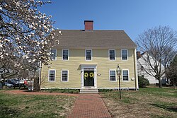
Simsbury Center is a census-designated place (CDP) that consists of the central settlement, and the neighborhoods immediately surrounding it, in the town of Simsbury, Connecticut, United States. As of the 2010 census, the CDP had a population of 5,836. The core area of the CDP is listed as the Simsbury Center Historic District on the National Register of Historic Places.

<span class="mw-page-title-main">Southwood Acres, Connecticut</span> Census-designated place in Connecticut, United States

Southwood Acres is a suburban neighborhood within the town of Enfield in northern Hartford County, Connecticut, United States. The neighborhood is listed as a census-designated place (CDP) by the U.S. Census Bureau and had a population of 7,657 at the 2010 census.

<span class="mw-page-title-main">Durham, Connecticut</span> Town in Connecticut, United States

Durham is a town in Middlesex County, Connecticut, United States. Durham is a former farming village on the Coginchaug River in central Connecticut. The town is part of the Lower Connecticut River Valley Planning Region. The population was 7,152 at the 2020 census. Every autumn, the town hosts the Durham Fair, the largest volunteer agricultural fair in New England.

<span class="mw-page-title-main">Suffield Depot, Connecticut</span> Census-designated place in Connecticut, United States

Suffield Depot is the name of a census-designated place (CDP) corresponding to the village of Suffield, the primary settlement of the town of Suffield, Connecticut, United States, in Hartford County. The population of the CDP was 1,325 as of the 2010 census.

<span class="mw-page-title-main">Canton Valley, Connecticut</span> Census-designated place in Connecticut, United States

Canton Valley is a village and census-designated place (CDP) in the town of Canton in Hartford County, Connecticut, United States. The population was 1,580 at the 2010 census. As of the 2017 census the population was 1,489.

<span class="mw-page-title-main">New Hartford Center, Connecticut</span> Census-designated place in Connecticut, United States

New Hartford Center is a census-designated place (CDP) in Litchfield County, Connecticut, United States. It comprises the village of New Hartford, the adjacent Pine Meadow Historic District, and some surrounding forest land, all within the town of New Hartford. As of the 2010 census, the population of New Hartford Center was 1,385, out of 6,970 in the entire town of New Hartford.

<span class="mw-page-title-main">Manchester (CDP), Connecticut</span> Census-designated place in Connecticut, United States

Manchester is a census-designated place (CDP) in Hartford County, Connecticut, United States, comprising the urban center of the town of Manchester. As of the 2010 census, the population of the CDP was 30,577, out of 58,241 in the entire town.

References

  1. 1 2 "Geographic Identifiers: 2010 Demographic Profile Data (G001): Glastonbury Center CDP, Connecticut". U.S. Census Bureau, American Factfinder. Archived from the original on February 12, 2020. Retrieved November 29, 2012.