Old Man of the Mountain

Last updated
Old Man of the Mountain
Great Stone Face, The Profile
Old Man of the Mountain 4-26-03 (cropped).jpg
Old Man of the Mountain on April 26, 2003, seven days before the collapse
Old Man of the Mountain
TypeRock formation (former)
Location Cannon Mountain, Franconia, New Hampshire, United States
Coordinates 44°09′38″N71°41′00″W / 44.1606203°N 71.6834169°W / 44.1606203; -71.6834169
Elevation3,130 feet (950 m)
Height40 feet (12 m)
Formed≈ 300 to 12,000 years ago
DemolishedMay 3, 2003 (collapsed)
USA New Hampshire relief location map.svg
Red pog.svg
Former location of the formation in New Hampshire

The Old Man of the Mountain, also called the Great Stone Face and the Profile, [1] [2] was a series of five granite cliff ledges on Cannon Mountain in Franconia, New Hampshire, United States, that appeared to be the jagged profile of a human face when viewed from the north. The rock formation, 1,200 feet (370 m) above Profile Lake, was 40 feet (12 m) tall and 25 feet (7.6 m) wide.

Contents

The Old Man of the Mountain is called "Stone Face" by the Abenaki and is a symbol within their culture. [3] It is also a symbol to the Mohawk people. The first written mention of the Old Man was in 1805. It became a landmark and a cultural icon for the state of New Hampshire. It collapsed on May 3, 2003. [4] After its collapse, residents considered replacing it with a replica, but the idea was ultimately rejected. It remains a visual icon on the state's license plates and in other places.

History

Old Man of the Mountain
Summer, 1972 - Historical Marker:
"OLD MAN OF THE MOUNTAIN - 'The Great Stone Face" - 48' forehead to chin; 1200' above Profile Lake; 3200' above sea level; first seen by white men in 1805." OldManOfTheMountainNH-USA-DrDennisBogdan-1972.jpg
Old Man of the Mountain
Summer, 1972 – Historical Marker:
"OLD MAN OF THE MOUNTAIN – 'The Great Stone Face" – 48' forehead to chin; 1200' above Profile Lake; 3200' above sea level; first seen by white men in 1805."

Franconia Notch is a U-shaped valley in the White Mountains that was shaped by glaciers. The Old Man formation was likely formed from freezing and thawing of water in cracks of the granite bedrock sometime after the retreat of glaciers 12,000 years ago. [5] The formation was first noted in the records of a Franconia surveying team around 1805. Francis Whitcomb and Luke Brooks, part of the surveying team, were the first two to record observing the Old Man. [5] The official state history says several groups of surveyors were working in the Franconia Notch area at the time and claimed credit for the discovery.

Indigenous legends

According to Abenaki legend, a human named Nis Kizos was born during an eclipse. He became a good leader and provider for his community. Nis Kizos was successful enough to attend Kchi Mahadan, a great gathering of other communities to trade. Tarlo, a beautiful Iroquois woman, returned with him. They fell in love. Tarlo had to return to her birth village because its people had been struck by a sickness. Nis Kizos promised he would live at the top of the mountain. By day he would look out for her, and at night he would light a fire to guide her back. With winter fast approaching, the elders sent Nis Kizos's brother Gezosa to bring him back. He was unsuccessful because Nis Kizos maintained his promise. Tarlo died in her birth village of sickness. After the winter Gezosa went back up the mountain to bring the news of Tarlo and retrieve Nis Kizos. He found no signs of the existence of Nis Kizos and was stricken with sadness. On his way back down the mountain he looked back and found Nis Kizos had become part of the mountain as a stone face to look after the land.

A modern addition to the Abenaki legend is that when Stone Face fell in 2003, he finally was re-united with Tarlo. The Great Circle was rejoined. [3]

Denise Ortakales published a children's book in 2005 called The Legend of the Old Man of the Mountain, which relates the Mohawk legend of the stone face. In the tale, Chief Pemigewassat loved a maiden named Minerwa of the Mohawk people, which brought peace between their tribes for a long time. When Minerwa went back home to visit her dying father, Chief Pemigewassat promised he would stay and wait for her to return. However, the Great Spirit claimed him during the winter, and his people buried him facing towards Minerwa to watch for her return. His face was immortalized in the stone as the stone face, forever waiting and watching. [6]

Post-colonial history

Old Man of the Mountain, early 1900s Old Man of the Mountian.GIF
Old Man of the Mountain, early 1900s

The Old Man became famous across the United States largely because of statesman Daniel Webster, a New Hampshire native, who once wrote: "Men hang out their signs indicative of their respective trades; shoemakers hang out a gigantic shoe; jewelers a monster watch, and the dentist hangs out a gold tooth; but up in the Mountains of New Hampshire, God Almighty has hung out a sign to show that there He makes men."

The writer Nathaniel Hawthorne used the Old Man as inspiration for his short story "The Great Stone Face", published in 1850, in which he described the formation as "a work of Nature in her mood of majestic playfulness".

The profile has been New Hampshire's state emblem since 1945. [7] It was put on the state's license plates and state route signs, and on the back of New Hampshire's statehood quarter, popularly promoted as the only U.S. coin with a profile on both sides. Before the collapse, it could be seen from special viewing areas along Interstate 93 in Franconia Notch State Park, approximately 80 miles (130 km) north of the state's capital, Concord.

Collapse

A composite photograph of the Old Man of the Mountain, made of photos taken before and after the collapse Old Man of the Mountain overlay 2.jpg
A composite photograph of the Old Man of the Mountain, made of photos taken before and after the collapse

Freezing and thawing opened fissures in the Old Man's "forehead". By the 1920s, the crack was wide enough to be mended with chains, and in 1957 the state legislature passed a $25,000 appropriation for a more elaborate weatherproofing, using 20 tons of fast-drying cement, plastic covering and steel rods and turnbuckles, plus a concrete gutter to divert runoff from above. A team from the state highway and park divisions maintained the patchwork each summer. [8]

Nevertheless, the formation collapsed to the ground between midnight and 2 a.m. on May 3, 2003. [4] Dismay over the collapse was so great that people visited to pay tribute, with some leaving flowers. [9] [10]

After the collapse

View recreated via one of the "steel profilers" located in Profiler Plaza, in 2019 Old Man of the Mountain steel profiler view.jpg
View recreated via one of the "steel profilers" located in Profiler Plaza, in 2019

Early after the collapse, many New Hampshire residents considered replacement with a replica. That idea was rejected by an official task force later in 2003 headed by former Governor Steve Merrill. [11]

In 2004, the state legislature considered, but did not accept, a proposal to change New Hampshire's state flag to include the profile. [12]

On the first anniversary of the collapse in May 2004, the Old Man of the Mountain Legacy Fund (OMMLF) began operating coin-operated viewfinders near the base of the cliff. When looking through them up at the cliff of Cannon Mountain one can see a "before" and "after" of how the Old Man of the Mountain used to appear. [4]

Seven years after the collapse, on June 24, 2010, the OMMLF, now the Friends of the Old Man of the Mountain, broke ground for the first phase of the state-sanctioned "Old Man of the Mountain Memorial" on a walkway along Profile Lake below Cannon Cliff. It consists of a viewing platform with "Steel Profilers", which, when aligned with the Cannon Cliff above, create what the profile looked like up on the cliff overlooking Franconia Notch. The project was overseen by Friends of the Old Man of the Mountain/Franconia Notch, [13] a committee that succeeded the Old Man of the Mountain Revitalization Task Force. The Legacy Fund is a private 501(c)(3) corporation with representatives from various state agencies and several private nonprofits. [14]

In 2013, the board called a halt to further fundraising. They announced their intention to spend what was left on minor improvements and dissolve the board. [11]

The memorial was completed in September 2020. [15]

Other proposals that were considered but rejected include:

Timeline of the Old Man

New Hampshire 1926 license plate.jpg
The formation on a 1926 New Hampshire license plate
StampOldManMountain.jpg
U. S. stamp issued in 1955. The plural version of the name is unusual.
New Hampshire quarter, reverse side, 2000.jpg
The reverse of the state quarter of New Hampshire features the Old Man of the Mountain, alongside the state motto "Live Free or Die".
NH Route 18.svg
New Hampshire route markers continue to feature the profile of the Old Man of the Mountain.

Details of the history of the Old Man of the Mountain include: [20]

See also

Related Research Articles

<span class="mw-page-title-main">Franconia, New Hampshire</span> Town in New Hampshire, United States

Franconia is a town in Grafton County, New Hampshire, United States. The population was 1,083 at the 2020 census. Set in the White Mountains, Franconia is home to the northern half of Franconia Notch State Park. Parts of the White Mountain National Forest are in the eastern and southern portions of the town. The Appalachian Trail crosses the town.

<span class="mw-page-title-main">Sugar Hill, New Hampshire</span> Town in New Hampshire, United States

Sugar Hill is a town in Grafton County, New Hampshire, United States. The population was 647 at the 2020 census, an increase over the figure of 563 tabulated in 2010. The town overlooks the White Mountain National Forest, with views of the Presidential, Franconia, Kinsman and Dalton ranges. Sugar Hill was incorporated as a town in 1962, the most recent in New Hampshire.

<span class="mw-page-title-main">White Mountains (New England)</span> Mountain range in New Hampshire and Maine, United States

The White Mountains are a mountain range covering about a quarter of the state of New Hampshire and a small portion of western Maine in the United States. They are a subrange of the northern Appalachian Mountains and the most rugged mountains in New England. Several of the higher peaks contain an Alpine tundra. The range is heavily visited due to its proximity to Boston, New York City, and Montreal.

<span class="mw-page-title-main">White Mountains Region</span>

The White Mountains Region is a tourism region designated by the New Hampshire Division of Travel and Tourism. It is located in northern New Hampshire in the United States and is named for the White Mountains, which cover most of the region. The southern boundary of the region begins at Piermont on the west, and runs east to Campton, then on to Conway and the Maine border. The northern boundary begins at Littleton and runs east to Gorham and the Maine border. The region to the north is known as the Great North Woods Region, which should not be confused with the larger and more general Great North Woods.

<span class="mw-page-title-main">Franconia Notch State Park</span> State park in New Hampshire, United States

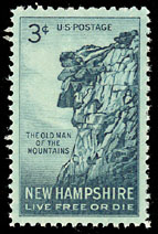
Franconia Notch State Park is a public recreation area and nature preserve that straddles eight miles (13 km) of Interstate 93 as it passes through Franconia Notch, a mountain pass between the Kinsman Range and Franconia Range in the White Mountains of northern New Hampshire, United States. The northern part of the park, including Cannon Mountain and Echo and Profile lakes, is in the town of Franconia, and the southern part, including Lonesome Lake and the Flume, is in Lincoln. Attractions in the state park include the Flume Gorge and visitor center, the Old Man of the Mountain historical site, fishing in Echo Lake and Profile Lake, and miles of hiking, biking and ski trails.

<span class="mw-page-title-main">Franconia Notch</span> Mountain pass in New Hampshire, USA

Franconia Notch is a major mountain pass through the White Mountains of New Hampshire. Dominated by Cannon Mountain to the west and Mount Lafayette to the east, it lies principally within Franconia Notch State Park and is traversed by the Franconia Notch Parkway. The parkway required a special act of Congress to sidestep design standards for the Interstate highway system because it is only one lane in each direction.

<span class="mw-page-title-main">Mount Lafayette</span> Mountain in New Hampshire, United States

Mount Lafayette is a 5,249-foot (1,600 m) mountain at the northern end of the Franconia Range in the White Mountains of New Hampshire, United States. It lies in the town of Franconia in Grafton County, and appears on the New England Fifty Finest list of the most topographically prominent peaks in New England. The mountain's upper reaches are located in the alpine zone, an area where only dwarf vegetation exists due to the harsh climate.

<span class="mw-page-title-main">Cannon Mountain (New Hampshire)</span>

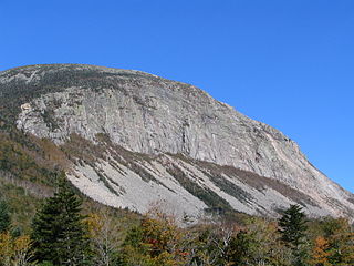
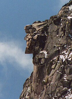
Cannon Mountain is a 4,080-foot (1,240 m) peak in the White Mountains of New Hampshire. It is known for both its technical rock and ice climbing on its cliff face and skiing at Cannon Mountain Ski Area. It was also home to the Old Man of the Mountain, until that formation collapsed on May 3, 2003.

<span class="mw-page-title-main">White Mountain art</span> 19th-century art depicting New Hampshire, US

White Mountain art is the body of work created during the 19th century by over four hundred artists who painted landscape scenes of the White Mountains of New Hampshire in order to promote the region and, consequently, sell their works of art.

<span class="mw-page-title-main">Profile Lake</span>

Profile Lake is a 13-acre (53,000 m2) water body located in Franconia Notch in the White Mountains of New Hampshire, at the foot of Cannon Mountain. The lake was given its name due to its location directly beneath the Old Man of the Mountain, a famous rock formation which collapsed in 2003. The lake is near the height of land in Franconia Notch; the lake's outlet is the Pemigewasset River, which flows south to the Merrimack River and ultimately the Gulf of Maine at Newburyport, Massachusetts.

<span class="mw-page-title-main">Echo Lake (Franconia Notch)</span> Water body in Grafton County, New Hampshire, United States

Echo Lake is a 38.2-acre (15.5 ha) water body located in Franconia Notch in the White Mountains of the U.S state of New Hampshire, at the foot of Cannon Mountain. The lake is in the Connecticut River watershed, near the height of land in Franconia Notch; water from the lake's outlet flows north via Lafayette Brook to the Gale River, then the Ammonoosuc River, and finally the Connecticut River to Long Island Sound, an arm of the Atlantic Ocean.

<span class="mw-page-title-main">Lonesome Lake (New Hampshire)</span>

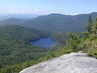
Lonesome Lake is a 12.2-acre (49,000 m2) water body located in Franconia Notch in the White Mountains of New Hampshire, south of Cannon Mountain. The lake is reachable by hiking trails from the Franconia Notch Parkway, including the Lafayette Place Campground, and takes approximately 2–3 hours. It features an Appalachian Mountain Club hut, which first opened in 1930, on its southwest shore.

<span class="mw-page-title-main">Kinsman Mountain</span>

Kinsman Mountain is a mountain located in Grafton County, New Hampshire. It is named after Nathan Kinsman, an early resident of Easton, New Hampshire, and is part of the Kinsman Range of the White Mountains. To the northeast, Kinsman is connected by The Cannon Balls ridge to Cannon Mountain.

<span class="mw-page-title-main">Pemigewasset Wilderness</span> Wilderness in the state of New Hampshire

The Pemigewasset Wilderness is a 45,000-acre (182 km2) federally designated Wilderness Area in the heart of New Hampshire's White Mountains. It is a part of the White Mountain National Forest. It is New Hampshire's largest wilderness area.

<span class="mw-page-title-main">Cannon Mountain Ski Area</span> Ski area in New Hampshire, United States

Cannon Mountain Ski Area is a state-owned ski resort located on Cannon Mountain in the White Mountains of New Hampshire, United States. Cannon is located within Franconia Notch State Park and offers 10 lifts servicing 265 acres (1.07 km2) of skiing. Cannon has 23 miles (37 km) of trails and a north-northeast exposure and has the only aerial tram in New Hampshire. Cannon has the most vertical of any ski area in New Hampshire, 2,180 feet (660 m), and is the seventh largest in New England. US Olympic skier Bode Miller grew up skiing at Cannon.

Conway granite is a typically pink biotite granite. It is amphibole-free and of coarse particle size.

<span class="mw-page-title-main">The Great Stone Face (Hawthorne)</span>

"The Great Stone Face" is a short story published by Nathaniel Hawthorne in 1850. The story reappeared in a full-length book, The Snow-Image, and Other Twice-Told Tales, published by Ticknor, Reed & Fields in 1852. It has since been republished and anthologized many times.

<span class="mw-page-title-main">Profile House</span> Building

The Profile House was a grand hotel in the White Mountains of New Hampshire, in the United States. Originally built in 1852 and opening for its first season in 1853, it was operated by several owners and partners until its final season under the ownership of Karl P. Abbott, when the hotel, at its seasonal peak, burned to the ground, leaving only the train depot standing in the fire's aftermath. Area attractions included Franconia Notch, the Great Boulder flume, Artist's Bluff, Mount Cannon, Profile Lake, Echo Lake, and Eagle Cliff. The Profile House boasted amenities such as running water, electricity and all of the comforts to which the affluent guests had become accustomed. The hotel was named for the iconic rock structure discovered by surveyors in 1805, that came to be known as Old Man of the Mountain.

<span class="mw-page-title-main">1964 NCAA Skiing Championships</span> American college skiing competition

The 1964 NCAA Skiing Championships were contested at the Cannon Mountain Ski Area in Franconia Notch, New Hampshire at the eleventh annual NCAA-sanctioned ski tournament to determine the individual and team national champions of men's collegiate alpine skiing, cross-country skiing, and ski jumping in the United States.

<span class="mw-page-title-main">Mount Pemigewasset</span> Mountain in the U.S. state of New Hampshire

Mount Pemigewasset, or Indian Head, is a mountain in Franconia Notch in the White Mountains in Grafton County, New Hampshire, United States. It lies near the town of Lincoln.

References

  1. Russell, Jenna (May 5, 2023). "New Hampshire's Old Man of the Mountain, 20 Years Gone, Still Bewitches - The rock formation collapsed in 2003, but it hasn't lost its hold on residents, who have passed on their affection to a new generation". The New York Times . Archived from the original on May 5, 2023. Retrieved May 5, 2023.
  2. "Franconia Notch". Encyclopædia Britannica . Chicago, Illinois: Encyclopædia Britannica, Inc. 2008. Retrieved January 31, 2008.
  3. 1 2 "The Wobanadenok". Indigenous New Hampshire Collaborative Collective. December 6, 2018. Retrieved November 22, 2021.
  4. 1 2 3 4 5 New Hampshire Division of Parks and Recreation: Old Man of the Mountain Historic Site Accessed: August 14, 2012.
  5. 1 2 Linowes, Jonathan. "Old Man of the Mountain Legacy Fund: Geology of the Old Man of the Mountain". www.oldmanofthemountainlegacyfund.org. Archived from the original on May 27, 2019. Retrieved March 30, 2017.
  6. "The Legend of the Old Man of the Mountain". The Free Library. Retrieved November 22, 2021.
  7. 1 2 New Hampshire Revised Statutes Annotated, Title I, Section 3:1
  8. Daniel Ford, The Country Northward (1976), p. 52.
  9. "Today is the 15th anniversary of Old Man of the Mountain's collapse". The Berlin Daily Sun . May 1, 2018. Retrieved January 10, 2019.
  10. Colquhoun, Laura (May 11, 2003). "Hundreds Gather for Goodbyes". New Hampshire Union Leader . p. A1.
  11. 1 2 Merrill, Steve. "Old Man of the Mountain Memorial". Live Free or Die Alliance. Retrieved March 10, 2017.
  12. J. Dennis Robinson (February 27, 2004). "Save the Seal, Keep the Ship". SeacoastNH.com. Retrieved July 6, 2010.
  13. Lorna Colquhoun (June 25, 2010). "Old Man's profile makes return". New Hampshire Union Leader . Retrieved July 6, 2010.
  14. "Old Man of the Mountain Legacy Fund". Old Man of the Mountain Legacy Fund. Retrieved July 6, 2010.
  15. 1 2 AP: "Old Man memorial hopes for more volunteers", September 14, 2020
  16. Garry Rayno (April 24, 2009). "Designer: Replace Old Man with walk-in glass replica". New Hampshire Union-Leader. Retrieved July 20, 2010.
  17. "Redefinition of the Old Man of the Mountain". Francis Treves, AIA. April 26, 2010. Retrieved May 3, 2010.
  18. Dave. "Replacing the Old Man of the Mountain – with information from the Architect". Towns and Trails. Retrieved May 4, 2021.
  19. Edge Mugga (January 7, 2009). "New Hampshire Proposal to Rebuild the Old Man of the Mountain: HB 192". Edge-On Blog. Retrieved July 6, 2010.
  20. "Old Man of the Mountain Legacy Fund: Historical Timeline". Archived from the original on 2015-12-11. Retrieved 2015-12-06.
  21. "Native American Heritage". New Hampshire Folk Life. State of New Hampshire. Retrieved June 24, 2023.
  22. Speck, Jerel (June 20, 2019). Clark, Susan (ed.). "The men who went to great heights to save the Old Man". Neighborhood News. Vol. 1, no. 33. Manchester, New Hampshire: Neighborhood News, Inc. p. 11.
  23. "Old Man Timeline". Old Man of the Mountain Legacy Fund. Retrieved April 20, 2017.
  24. New Hampshire Revised Statutes Annotated, Title LXII, Section 634:2
  25. CBSBoston.com Staff (March 22, 2023). "NH rep likens Old Man of the Mountain collapse to Twin Towers falling on 9/11". CBS Boston. CBS Broadcasting Inc. Retrieved March 23, 2023.
  26. Landrigan, Kevin (May 3, 2023). "Old Man of the Mountain gets a day" . New Hampshire Union Leader . Retrieved May 4, 2023.
  27. New Hampshire Revised Statutes Annotated, Title I, Section 4:13-dd

Further reading

Listen to this article (7 minutes)
Sound-icon.svg
This audio file was created from a revision of this article dated 12 May 2009 (2009-05-12), and does not reflect subsequent edits.