Old Saybrook Center, Connecticut

Last updated

Old Saybrook Center, Connecticut
Town Hall, Old Saybrook CT.jpg
Town Hall
USA Connecticut location map.svg
Red pog.svg
Old Saybrook Center
Usa edcp location map.svg
Red pog.svg
Old Saybrook Center
Coordinates: 41°17′34″N72°22′54″W / 41.29278°N 72.38167°W / 41.29278; -72.38167 [1]
Country United States of America
State Connecticut
County Middlesex
Town Old Saybrook
Area
[2]
  Total2.88 sq mi (7.5 km2)
  Land1.97 sq mi (5.1 km2)
  Water0.91 sq mi (2.4 km2)
Elevation
16 ft (5 m)
Population
 (2020) [3]
  Total2,278
Time zone UTC-5 (EST)
  Summer (DST) UTC-4 (EDT)
ZIP code
06475 (Old Saybrook)
Area code 860
FIPS code 09-57390
GNIS feature ID2377847 [1]

Old Saybrook Center is the primary village and a census-designated place (CDP) in the town of Old Saybrook, Middlesex County, Connecticut, United States. The population was 2,278 at the 2020 census, [3] out of 10,481 in the entire town of Old Saybrook. The CDP includes the traditional town center and the peninsula known as Saybrook Point. [4]

Contents

Geography

Old Saybrook Center is in the southeast part of Middlesex County, in the central and eastern part of the town of Old Saybrook. It is bordered to the east by the tidal Connecticut River and its coves, North Cove near the center of the community and South Cove along the southern edge of the community. Saybrook Point, part of the CDP, occupies the land between the two coves.

U.S. Route 1 passes through the northwest part of the community, leading west 8 miles (13 km) to Clinton and northeast 4 miles (6 km) to Old Lyme Center. Connecticut Route 154 passes through the center of Old Saybrook and leads north 5 miles (8 km) to Essex Village and southeast 3 miles (5 km) to Fenwick.

According to the United States Census Bureau, the Old Saybrook Center CDP has a total area of 2.9 square miles (7.5 km2), of which 2.0 square miles (5.2 km2) are land and 0.9 square miles (2.3 km2), or 31.47%, are water. [2]

Demographics

As of the census [5] of 2000, there were 1,962 people, 908 households, and 548 families residing in the CDP. The population density was 994.3 inhabitants per square mile (383.9/km2). There were 984 housing units at an average density of 498.7 per square mile (192.5/km2). The racial makeup of the CDP was 96.08% White, 0.61% African American, 0.05% Native American, 2.14% Asian, 0.20% Pacific Islander, 0.66% from other races, and 0.25% from two or more races. Hispanic or Latino of any race were 1.68% of the population.

There were 908 households, out of which 19.9% had children under the age of 18 living with them, 50.6% were married couples living together, 6.8% had a female householder with no husband present, and 39.6% were non-families. 34.6% of all households were made up of individuals, and 19.6% had someone living alone who was 65 years of age or older. The average household size was 2.14 and the average family size was 2.74.

In the CDP, the population was spread out, with 17.3% under the age of 18, 4.3% from 18 to 24, 22.8% from 25 to 44, 28.2% from 45 to 64, and 27.3% who were 65 years of age or older. The median age was 48 years. For every 100 females, there were 88.5 males. For every 100 females age 18 and over, there were 84.9 males.

The median income for a household in the CDP was $50,625, and the median income for a family was $63,021. Males had a median income of $46,522 versus $41,250 for females. The per capita income for the CDP was $33,217. None of the families and 4.6% of the population were living below the poverty line, including no under eighteens and 7.5% of those over 64.

Related Research Articles

<span class="mw-page-title-main">Middlesex County, Connecticut</span> County in Connecticut, United States

Middlesex County is a county in the south central part of the U.S. state of Connecticut. As of the 2020 census, the population was 164,245. The county was created in May 1785 from portions of Hartford County and New London County.

<span class="mw-page-title-main">Elfin Cove, Alaska</span> Census-designated place in Alaska, United States

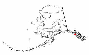
Elfin Cove is a census-designated place (CDP) near the northwestern corner of Chichagof Island in Hoonah-Angoon Census Area, Alaska, United States. The population was 20 at the 2010 census, down from 32 at the 2000 census.

<span class="mw-page-title-main">Kensington, Connecticut</span> Census-designated place in Connecticut, United States

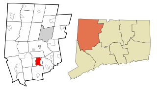
Kensington is a census-designated place (CDP) and section of the town of Berlin in Hartford County, Connecticut, United States. The Berlin town offices are located in Kensington. The population was 8,459 at the 2010 census.

<span class="mw-page-title-main">North Granby, Connecticut</span> Census-designated place in Connecticut, United States

North Granby is a village and census-designated place (CDP) in Hartford County, Connecticut, United States. It is part of the town of Granby. The population was 1,944 at the 2010 census.

<span class="mw-page-title-main">Terramuggus, Connecticut</span> Census-designated place in Connecticut, United States

Terramuggus is a census-designated place (CDP) in the town of Marlborough, Hartford County, Connecticut, United States. It contains the town center village and surrounding areas. The population was 1,025 at the 2010 census.

<span class="mw-page-title-main">Chester, Connecticut</span> Town in Connecticut, United States

Chester is a town in Middlesex County, Connecticut, United States. The town is part of the Lower Connecticut River Valley Planning Region. The population was 3,749 at the 2020 census. The town center is defined by the U.S. Census Bureau as a census-designated place (CDP). The name is a transfer from Chester, in England.

<span class="mw-page-title-main">Deep River, Connecticut</span> Town in Connecticut, United States

Deep River is a town in Middlesex County, Connecticut. The town is part of the Lower Connecticut River Valley Planning Region. The population was 4,415 at the 2020 census. The town center is designated by the U.S. Census Bureau as a census-designated place (CDP). Deep River is part of what the locals call the "Tri-town Area", made up of the towns of Deep River, Chester, and Essex.

<span class="mw-page-title-main">Essex Village, Connecticut</span> Census-designated place in Connecticut, United States

Essex Village is a village and census-designated place (CDP) in the town of Essex, Connecticut, in the United States. The population was 2,583 at the 2020 census, out of 6,733 in the entire town of Essex. The government offices of the town are located within the village.

<span class="mw-page-title-main">Fenwick, Connecticut</span> Borough in Connecticut, United States

Fenwick is a borough in Middlesex County, Connecticut, United States, in the town of Old Saybrook. The borough is part of the Lower Connecticut River Valley Planning Region. The population was 53 at the 2020 census, making it the least populous borough in Connecticut. Most of the borough is included in the Fenwick Historic District, listed on the National Register of Historic Places. In 1995, the district included 66 contributing buildings and one other contributing site.

<span class="mw-page-title-main">Higganum, Connecticut</span> Census-designated place in Connecticut, United States

Higganum is a village and census-designated place (CDP) in the town of Haddam, a part of Middlesex County, Connecticut, United States. The population was 2,089 at the 2020 census.

<span class="mw-page-title-main">Old Saybrook, Connecticut</span> Town in Connecticut, United States

Old Saybrook is a town in Middlesex County, Connecticut, United States. The town is part of the Lower Connecticut River Valley Planning Region. The population was 10,481 at the 2020 census. It contains the incorporated borough of Fenwick, and the census-designated places of Old Saybrook Center and Saybrook Manor.

Saybrook Manor is a community and census-designated place (CDP) in Old Saybrook, a town in Middlesex County, Connecticut, United States. The population was 1,127 at the 2020 census. The Saybrook Manor section is generally the area south of U.S. Route 1 between the Westbrook town line and the Oyster River.

<span class="mw-page-title-main">Westbrook, Connecticut</span> Town in Connecticut, United States

Westbrook is a town in Middlesex County, Connecticut, United States. The town is part of the Lower Connecticut River Valley Planning Region. The population was 6,769 at the 2020 census. The town center is classified by the U.S. Census Bureau as a census-designated place (CDP).

<span class="mw-page-title-main">Long Hill, Groton, Connecticut</span> Census-designated place in Connecticut, United States

Long Hill is a census-designated place (CDP) in the town of Groton in New London County, Connecticut, United States. The population was 4,205 at the 2010 census.

<span class="mw-page-title-main">Simsbury Center, Connecticut</span> Census-designated place in Connecticut, United States

Simsbury Center is a census-designated place (CDP) that consists of the central settlement, and the neighborhoods immediately surrounding it, in the town of Simsbury, Connecticut, in the United States. As of the 2010 census, the CDP had a population of 5,836. The core area of the CDP is listed as the Simsbury Center Historic District on the National Register of Historic Places.

Melrose Park is a suburban community and census-designated place (CDP) in Cayuga County, New York, United States. The population was 2,294 at the 2010 census. It is a suburb of Auburn, located south of the city in the town of Owasco.

<span class="mw-page-title-main">Bethlehem Village, Connecticut</span> Census-designated place in Connecticut, United States

Bethlehem Village is a census-designated place (CDP) within the town of Bethlehem in Litchfield County, Connecticut, United States. The CDP includes the Bethlehem Green Historic District at the town center, as well as surrounding residential and rural land. As of the 2010 census, the CDP had a population of 2,021, out of a population of 3,607 for the entire town of Bethlehem.

<span class="mw-page-title-main">Suffield Depot, Connecticut</span> Census-designated place in Connecticut, United States

Suffield Depot is the name of a census-designated place (CDP) corresponding to the village of Suffield, the primary settlement of the town of Suffield, Connecticut, in Hartford County. The population of the CDP was 1,325 as of the 2010 census.

<span class="mw-page-title-main">Glastonbury Center, Connecticut</span> Census-designated place in Connecticut, United States

Glastonbury Center is a census-designated place (CDP) that constitutes the densely populated center of the town of Glastonbury in Hartford County, Connecticut, United States. The population was 7,387 at the 2010 census, out of a total town population of 34,427.

<span class="mw-page-title-main">Clinton, Connecticut</span> Town in Connecticut, United States

Clinton is a town in Middlesex County, Connecticut, United States. The town is part of the Lower Connecticut River Valley Planning Region. The population of the town was 13,185 at the 2020 census. The town center along the shore line was listed as a census-designated place (CDP) by the U.S. Census Bureau in the 2020 census.

References

  1. 1 2 "Old Saybrook Census Designated Place". Geographic Names Information System . United States Geological Survey, United States Department of the Interior.
  2. 1 2 "2022 U.S. Gazetteer Files: Connecticut". United States Census Bureau. Retrieved December 12, 2022.
  3. 1 2 "P1. Race – Old Saybrook Center CDP, Connecticut: 2020 DEC Redistricting Data (PL 94-171)". U.S. Census Bureau. Retrieved December 12, 2022.
  4. "TIGERweb: Old Saybrook Center CDP, Connecticut". Geography Division, U.S. Census Bureau. Retrieved December 12, 2022.
  5. "U.S. Census website". United States Census Bureau . Retrieved January 31, 2008.