
Deep River is a town in Middlesex County, Connecticut. The town is part of the Lower Connecticut River Valley Planning Region. The population was 4,415 at the 2020 census. The town center is designated by the U.S. Census Bureau as a census-designated place (CDP). Deep River is part of what the locals call the "Tri-town Area", made up of the towns of Deep River, Chester, and Essex.

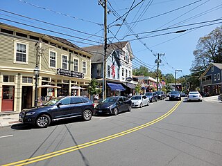
Essex Village is a village and census-designated place (CDP) in the town of Essex, Connecticut, in the United States. The population was 2,583 at the 2020 census, out of 6,733 in the entire town of Essex. The government offices of the town are located within the village.

Higganum is a village and census-designated place (CDP) in the town of Haddam, a part of Middlesex County, Connecticut, United States. The population was 2,089 at the 2020 census.
Old Saybrook Center is the primary village and a census-designated place (CDP) in the town of Old Saybrook, Middlesex County, Connecticut, United States. The population was 2,278 at the 2020 census, out of 10,481 in the entire town of Old Saybrook. The CDP includes the traditional town center and the peninsula known as Saybrook Point.
Saybrook Manor is a community and census-designated place (CDP) in Old Saybrook, a town in Middlesex County, Connecticut, United States. The population was 1,127 at the 2020 census. The Saybrook Manor section is generally the area south of U.S. Route 1 between the Westbrook town line and the Oyster River.

Lake Pocotopaug is an unincorporated village and census-designated place (CDP) in the town of East Hampton in Middlesex County, Connecticut, United States. As of the 2020 census, it had a population of 4,901, up from 3,436 in 2010.
Clinton is a census-designated place (CDP) comprising the primary village in the town of Clinton, Middlesex County, Connecticut, United States. It is in the southwest corner of the town, bordered to the west, across the Hammonasset River, by the town of Madison in New Haven County, to the north by Interstate 95, and to the south by Clinton Harbor, an inlet of Long Island Sound. As of the 2020 census, the CDP had a population of 3,441, out of 13,185 in the entire town of Clinton.
East Hampton is a census-designated place (CDP) comprising the primary village and adjacent residential and rural land in the town of East Hampton, Middlesex County, Connecticut, United States. It is in the central and eastern portions of the town, bordered to the north by the East Hampton community of Lake Pocotopaug and to the east by the town of Colchester in New London County and the town of Marlborough in Hartford County. As of the 2020 census, the East Hampton CDP had a population of 2,960, out of 12,717 in the entire town of East Hampton.
Portland is a census-designated place (CDP) comprising the primary village and adjacent residential land in the town of Portland, Middlesex County, Connecticut, United States. It is in the southwest part of the town, bordered to the west and south by the Connecticut River, which forms the border with Cromwell to the west and Middletown to the south. The Portland CDP extends north along Main Street to its junction with Gospel Lane at Fogelmarks Corners, and the eastern extent of the CDP is at Rose Hill Road and Collins Hill Road. The CDP includes the neighborhood of Gildersleeve in the north.
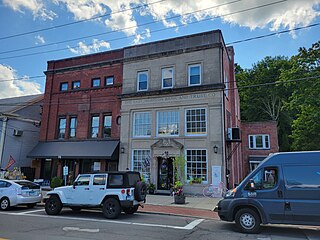
Chester Center is a census-designated place (CDP) comprising the primary village in the town of Chester, Middlesex County, Connecticut, United States. It is in the southeast corner of the town, bordered to the south by the town of Deep River and to the southwest largely by the Connecticut Route 9 freeway. As of the 2020 census, Chester Center had a population of 1,720, out of 3,749 in the entire town of Chester.
Westbrook Center is a census-designated place (CDP) comprising the primary village and adjacent residential land in the town of Westbrook, Middlesex County, Connecticut, United States. It is in the southern part of the town, along U.S. Route 1 and bordered to the south by Long Island Sound. To the east it is bordered by the town of Old Saybrook, and the west and northwest border of the CDP is the Patchogue River. As of the 2020 census, the CDP had a population of 2,220, out of 6,769 in the entire town of Westbrook.

North Haverhill is an unincorporated community and census-designated place (CDP) in, and the county seat of, Grafton County, New Hampshire. It is one of several villages in the town of Haverhill. As of the 2020 census, North Haverhill had a population of 843.

Wilton Center is a neighborhood/section and census-designated place (CDP) in the town of Wilton in Fairfield County, Connecticut, United States. As of the 2010 census it had a population of 732. The CDP partially overlaps the Wilton Center Historic District.
Fairlee is the primary village and a census-designated place (CDP) in the town of Fairlee, Orange County, Vermont, United States. As of the 2020 census, it had a population of 198 out of 988 in the entire town of Fairlee.
Wilmington is the primary village and a census-designated place (CDP) in the town of Wilmington, Windham County, Vermont, United States. As of the 2020 census, it had a population of 439, compared to 2,255 in the entire town. The center of the village is part of the Wilmington Village Historic District.
Chelsea is the primary village and a census-designated place (CDP) in the town of Chelsea, Orange County, Vermont, United States. It was first listed as a CDP prior to the 2020 census.
Connecticut Farms is a neighborhood and census-designated place (CDP) within Union Township, Union County, in the U.S. state of New Jersey. It was first listed as a CDP prior to the 2020 census.
Grafton is the central village and a census-designated place (CDP) in the town of Grafton, Windham County, Vermont, United States. As of the 2020 census, it had a population of 49, compared to 645 in the entire town.
Whitingham is the central village and a census-designated place (CDP) in the town of Whitingham, Windham County, Vermont, United States. As of the 2020 census, it had a population of 91, compared to 1,344 in the entire town. Part of the village comprises the Whitingham Village Historic District.
West Woodstock is an unincorporated village and census-designated place (CDP) in the town of Woodstock, Windsor County, Vermont, United States. As of the 2020 census, it had a population of 401.


