Union Vale, New York

Last updated

Union Vale, New York
Sprout Creek.JPG
Sprout Creek in Verbank
Seal of the Town of Union Vale, New York.jpg
Dutchess County New York incorporated areas Union Vale highlighted.svg
Location of Union Vale, New York
Coordinates: 41°41′53″N73°41′57″W / 41.69806°N 73.69917°W / 41.69806; -73.69917
Country United States
State New York
County Dutchess
Established1827
Government
  Type Town Council
   Town Supervisor Steve Frazier (R)
   Town Council
Members' List
Area
[1]
  Total37.81 sq mi (97.92 km2)
  Land37.48 sq mi (97.08 km2)
  Water0.32 sq mi (0.84 km2)
Elevation
495 ft (151 m)
Population
 (2020)
  Total4,558
Time zone UTC-5 (Eastern (EST))
  Summer (DST) UTC-4 (EDT)
FIPS code 36-027-76166
GNIS feature ID0979573
Website unionvaleny.us

Union Vale is a town in Dutchess County, New York, United States. The population was 4,558 at the 2020 census. [2]

Contents

The town is in the south-central part of the county. It is part of the Poughkeepsie–Newburgh–Middletown, NY Metropolitan Statistical Area as well as the larger New York–Newark–Bridgeport, NY-NJ-CT-PA Combined Statistical Area. The town is 15 miles (24 km) east of the city of Poughkeepsie and 70 miles (110 km) north of New York City.

History

The region was originally part of the Beekman Patent. The town was first settled circa 1716, and was formed in 1827 from the towns of Beekman and LaGrange.

Geography

According to the United States Census Bureau, the town of Union Vale has a total area of 37.8 square miles (97.9 km2), of which 37.5 square miles (97.1 km2) is land and 0.31 square miles (0.8 km2), or 0.86%, is water. [3] The highest point is atop Clove Mountain, at 1,400 feet (430 m) above sea level.

The towns adjacent to Union Vale are Beekman to the south, LaGrange to the west, Washington to the north, and Dover to the east.

New York State Route 55 runs through the southwestern part of the town.

Sky Acres Airport, a general aviation facility, is located in the northwestern part of the town. [4]

The Young Judaea Camp Sprout Lake is located in Verbank, which was established in 1976 as a camp for children grades 2–8, focused on Zionist and Jewish education. [5]

Parks and recreation

Union Vale has two town parks, Tymor Park and Frederick E. Godfrey Memorial Park.

The larger of these is Tymor Park, which encompasses nearly 500 acres (2.0 km2) and is the largest municipal park in the state of New York. [6] It has various recreational facilities such as sports fields, an outdoor pool, playground, pavilions, a senior center, rental halls, equestrian center, camping areas, a fishing pond, tennis courts, basketball courts, volleyball courts, historical sites, and over 12 miles (19 km) of hiking/biking/equestrian trails.

Frederick E. Godfrey Memorial Park (Godfrey Park) is 12 acres (49,000 m2) and includes hiking trails, a playground, basketball court, volleyball court, restrooms, and a baseball/softball field.

There is a private golf course, The Links at Union Vale, on the western side of the town. [7]

Demographics

Historical population
CensusPop.Note
1830 1,833
1840 1,498−18.3%
1850 1,5523.6%
1860 1,502−3.2%
1870 1,434−4.5%
1880 1,407−1.9%
1890 1,033−26.6%
1900 945−8.5%
1910 1,09716.1%
1920 987−10.0%
1930 1,0253.9%
1940 1,0563.0%
1950 970−8.1%
1960 1,13817.3%
1970 1,70249.6%
1980 2,65856.2%
1990 3,57734.6%
2000 4,54627.1%
2010 4,8777.3%
2020 4,558−6.5%
U.S. Decennial Census [8]

As of the census [9] of 2000, there were 4,546 people, 1,359 households, and 1,141 families residing in the town. The population density was 120.6 inhabitants per square mile (46.6/km2). There were 1,464 housing units at an average density of 38.8 per square mile (15.0/km2). The racial makeup of the town was 94.24% white, 2.35% African American, 0.11% Native American, 1.19% Asian, 0.04% Pacific Islander, 1.03% from other races, and 1.03% from two or more races. Hispanic or Latino of any race were 3.43% of the population.

There were 1,359 households, out of which 47.0% had children under the age of 18 living with them, 75.9% were married couples living together, 5.6% had a female householder with no husband present, and 16.0% were non-families. 12.9% of all households were made up of individuals, and 4.9% had someone living alone who was 65 years of age or older. The average household size was 3.10 and the average family size was 3.40.

In the town, the population was spread out, with 28.9% under the age of 18, 5.5% from 18 to 24, 30.1% from 25 to 44, 25.6% from 45 to 64, and 9.9% who were 65 years of age or older. The median age was 38 years. For every 100 females, there were 100.7 males. For every 100 females age 18 and over, there were 100.3 males.

The median income for a household in the town was $70,500, and the median income for a family was $72,697. Males had a median income of $51,382 versus $29,643 for females. The per capita income for the town was $24,535. About 0.8% of families and 2.9% of the population were below the poverty line, including 1.7% of those under age 18 and none of those age 65 or over.

Communities and locations in Union Vale

Oswego

Oswego is a former hamlet, later a ghost town, in the northwestern part of the town, north of Lagrangeville and south of Verbank, now part of the hamlet of Moores Mills, shared with the town of LaGrange. It is located directly southeast of Sky Acres airport. A historic marker set by the state government marks the spot of the former hamlet. The Oswego Meeting House and Friends' Cemetery was listed on the National Register of Historic Places in 1989. [10] [11]

This ghost town shares a name with a city in the northern part of the state, Oswego.

Related Research Articles

<span class="mw-page-title-main">Dutchess County, New York</span> County in New York, United States

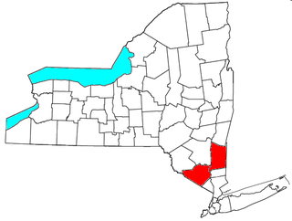
Dutchess County is a county in the U.S. state of New York. As of the 2020 census, the population was 295,911. The county seat is the city of Poughkeepsie. The county was created in 1683, one of New York's first twelve counties, and later organized in 1713. The county is part of the Hudson Valley region of the state.

<span class="mw-page-title-main">Beekman, New York</span> Town in New York, United States

Beekman is a town in Dutchess County, New York, United States. It is part of the Poughkeepsie–Newburgh–Middletown, NY Metropolitan Statistical Area as well as the larger New York–Newark–Bridgeport, NY-NJ-CT-PA Combined Statistical Area. The population was 14,172 at the 2020 census. The town was named after Henry Beekman, a 17th-century land owner.

<span class="mw-page-title-main">East Fishkill, New York</span> Town in New York, United States

East Fishkill is a town on the southern border of Dutchess County, New York, United States. The population was 29,707 at the 2020 census. Until its creation in 1849, the town was the eastern portion of the town of Fishkill.

<span class="mw-page-title-main">Hillside Lake, New York</span> Census-designated place in New York, United States

Hillside Lake is a hamlet and census-designated place (CDP) in Dutchess County, New York, United States. The population was 1,084 at the 2010 census. It is part of the Poughkeepsie–Newburgh–Middletown, NY Metropolitan Statistical Area as well as the larger New York–Newark–Bridgeport, NY-NJ-CT-PA Combined Statistical Area.

<span class="mw-page-title-main">LaGrange, New York</span> Town in New York, United States

LaGrange is a town in Dutchess County, New York, United States. The population was 15,975 at the 2020 census. The town was named after the estate of the Marquis de Lafayette.

<span class="mw-page-title-main">Milan, New York</span> Town in New York, United States

Milan is a town in Dutchess County, New York, United States. The town is in the northern part of the county and is very rural. As of the 2020 census it had a population of 2,245, slightly down from 2,370 in 2010. Milan is located approximately 90 miles (140 km) north of New York City, 60 miles (97 km) south of Albany, and 150 miles (240 km) west of Boston. It is bordered by Rhinebeck and Red Hook to the west, Pine Plains to the east, Stanford to the southeast, Clinton to the south, and Gallatin to the north by Columbia County. The only major route in the town is the historic Taconic State Parkway, though NY 199 serves as the main local thoroughfare.

<span class="mw-page-title-main">Stanford, New York</span> Town in New York, United States

Stanford is a town in the north-central part of Dutchess County, New York, United States. The population was 3,628 at the 2020 census, down from 3,823 at the 2010 census.

<span class="mw-page-title-main">Washington, New York</span> Town in Dutchess County, New York, US

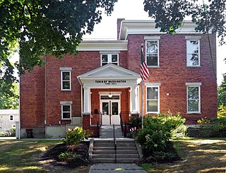
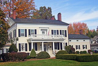
Washington is a town in Dutchess County, New York, United States. The population was 4,522 at the 2020 census. The town is named after George Washington, who passed through the town during the Revolution.

<span class="mw-page-title-main">Granby, New York</span> Town in New York, United States

Granby is a town in Oswego County, New York, United States. The population was 6,821 at the 2010 census.

<span class="mw-page-title-main">Hastings, New York</span> Town in New York, United States

Hastings is a town in Oswego County, New York, United States. Its population was 9,450 at the 2010 census. It is named after Hastings Curtiss, a prominent citizen and member of the State Assembly in 1824.

<span class="mw-page-title-main">Scriba, New York</span> Town in New York, United States

Scriba is a town in Oswego County, New York, United States. The population was 6,840 at the 2010 census. The town is named after landowner George Scriba.

<span class="mw-page-title-main">Volney, New York</span> Town in New York, United States

Volney is a town in Oswego County, New York, United States. The population was 5,926 at the 2010 census. The town was named after a French author, Constantin François de Chassebœuf, comte de Volney, who toured the area in 1808.

<span class="mw-page-title-main">Patterson, New York</span> Town in New York, United States

Patterson is a town in Putnam County, New York, United States. The town is in the northeastern part of the county. Interstate 84 passes through the southwestern section of the town. The population was 11,541 at the 2020 census. The town is named after early farmer Matthew Paterson. The reason Patterson was spelled with two "t"s was due to the looseness with which Paterson spelled his own last name.

<span class="mw-page-title-main">Pawling (town), New York</span> Town in New York, United States

Pawling is a town in Dutchess County, New York, United States. Its population was 8,012 at the 2020 census. The town is named after Catherine Pauling, the daughter of Henry Beekman, who held the second largest land patent in the county. The town is in the southeastern part of the county, and contains a village of the same name.

<span class="mw-page-title-main">Poughkeepsie (town), New York</span> Town in New York, United States

Poughkeepsie, officially the Town of Poughkeepsie, is a town in Dutchess County, New York, United States. As of the 2020 United States Census, the population was 45,471. The name is derived from the native compound Uppuqui-ipis-ing, from Uppuqui meaning "lodge-covered", plus ipis meaning "little water", plus ing meaning "place", all of which translates to "the reed-covered lodge by the little water place". This later evolved into Apokeepsing, then into Poughkeepsing, and finally Poughkeepsie.

<span class="mw-page-title-main">Hunter, New York</span> Town in New York, United States

Hunter is a town located in Greene County, New York, United States. The population was 3,035 at the time of the 2020 census. The town contains two villages, one named Hunter on the west, and the second called Tannersville, as well as a number of hamlets such as Haines Falls, Platte Clove, Lanesville and Edgewood. Additionally, there are three residential parks location within town limits: Onteora Park, Twilight Park and Elka Park. The town is on the southern border of Greene County and abuts the towns of Woodstock and Saugerties, located in Ulster County.

<span class="mw-page-title-main">Oswego (town), New York</span> Town in New York, United States

Oswego is a town in Oswego County, in the U.S. state of New York. The population was 7,984 at the 2010 census.

<span class="mw-page-title-main">Fishkill Creek</span> Tributary of the Hudson River in southern Dutchess County, New York

Fishkill Creek is a tributary of the Hudson River in Dutchess County, New York, United States. At 33.5 miles (53.9 km) it is the second longest stream in the county, after Wappinger Creek. It rises in the town of Union Vale and flows generally southwest to a small estuary on the Hudson just south of Beacon. Part of its 193-square-mile (500 km2) watershed is in Putnam County to the south. Sprout Creek, the county's third-longest creek, is its most significant tributary. Whaley and Sylvan lakes and Beacon Reservoir, its largest, deepest and highest lakes, are among the bodies of water within the watershed.

<span class="mw-page-title-main">Verbank, New York</span> Hamlet in New York, United States

Verbank is a hamlet in the town of Union Vale in Dutchess County, New York, United States. Verbank is served by a post office with the ZIP code of 12585; the ZCTA for ZIP Code 12585 had a population of 956 at the 2000 census.

<span class="mw-page-title-main">Kiryas Joel-Poughkeepsie-Newburgh metropolitan area</span> Metropolitan statistical area in New York, United States

The Kiryas Joel-Poughkeepsie-Newburgh, NY Metropolitan Statistical Area, as defined by the United States Office of Management and Budget, is an area consisting of two counties in New York's Hudson Valley, with the municipalities of Kiryas Joel, Poughkeepsie, and Newburgh as its principal cities. As of the 2020 census, the MSA had a population of 679,221. The area was centered on the urban area of Poughkeepsie-Newburgh. Prior to July 2023, it was known as the Poughkeepsie-Newburgh-Middletown, NY Metropolitan Statistical Area; whereupon it was renamed to its current name, to reflect population changes among its largest municipalities.

References

  1. "2016 U.S. Gazetteer Files". United States Census Bureau. Retrieved July 4, 2017.
  2. United States Census Bureau, 2020 Report, Union Vale town, New York
  3. "Geographic Identifiers: 2010 Demographic Profile Data (G001): Union Vale town, Dutchess County, New York". U.S. Census Bureau, American Factfinder. Archived from the original on February 13, 2020. Retrieved November 16, 2015.
  4. Sky Acres Aireport website. Accessed July 22, 2013.
  5. "Camp Sprout Lake - Jewish Sleepaway Camp in the Hudson Valley". Camp Young Judaea Sprout Lake. Retrieved July 18, 2023.
  6. "TOWN OF UNION VALE IS FIRST TO PASS A POLLINATOR PROTECTION POLICY IN DUTCHESS COUNTY, NY". The Harlem Valley News. Retrieved January 3, 2018.
  7. The Links at Union Vale website. Accessed July 22, 2013.
  8. "Census of Population and Housing". Census.gov. Retrieved June 4, 2015.
  9. "U.S. Census website". United States Census Bureau . Retrieved January 31, 2008.
  10. "National Register Information System". National Register of Historic Places . National Park Service. March 13, 2009.
  11. Oswego Meeting House And Friends' Cemetery in Moore's Mill at the Historic Places website. Accessed July 22, 2013.