Related Research Articles

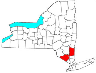
Dutchess County is a county in the U.S. state of New York. As of the 2020 census, the population was 295,911. The county seat is the city of Poughkeepsie. The county was created in 1683, one of New York's first twelve counties, and later organized in 1713. It is located in the Mid-Hudson Region of the Hudson Valley, north of New York City.

Clinton is a town in Dutchess County, New York, United States. The population was 4,037 in the 2020 census, down from 4,312 in the 2010 census.
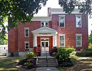
Washington is a town in Dutchess County, New York, United States. The population was 4,522 at the 2020 census. The town is named after George Washington, who passed through the town during the Revolution.
Pleasant Plains may refer to several places in the United States of America:

Pine Plains is a town in Dutchess County, New York, United States. The population was 2,218 at the 2020 census.

Pleasant Valley is a town in Dutchess County, within the Hudson Valley of New York, United States. The population was 9,799 at the 2020 census. The town is centrally located in the county, northeast of the city of Poughkeepsie. U.S. Route 44 passes through the town.

Poughkeepsie, officially the Town of Poughkeepsie, is a town in Dutchess County, New York, United States. As of the 2020 United States Census, the population was 45,471. The name is derived from the native term Uppuqui meaning "lodge-covered", plus ipis meaning "little water", plus ing meaning "place", all of which translates to "the reed-covered lodge by the little water place", or Uppuqui-ipis-ing. This later evolved into Apokeepsing, then into Poughkeepsing, and finally Poughkeepsie.

The U.S. state of New York currently comprises 26 congressional districts. Each district elects one member of the United States House of Representatives who sits on its behalf. The state was redistricted in 2022, following the 2020 U.S. census. It lost one seat in Congress.
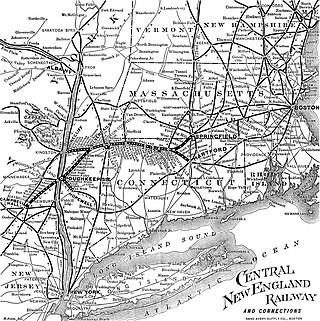
The Central New England Railway was a railroad from Hartford, Connecticut, and Springfield, Massachusetts, west across northern Connecticut and across the Hudson River on the Poughkeepsie Bridge to Maybrook, New York. It was part of the Poughkeepsie Bridge Route, an alliance between railroads for a passenger route from Washington to Boston, and was acquired by the New York, New Haven & Hartford Railroad in 1904. The New Haven ran the CNE as a separate company until finally merging it in 1927. The vast majority of the system was abandoned by the 1930s and 1940s. Surviving portions of the Central New England Railway are operated by the Central New England Railroad and the Housatonic Railroad.

Area codes 518 and 838 are telephone area codes in the North American Numbering Plan for eastern Upstate New York in the United States. 518 is one of the 86 original North American area codes created in 1947. Area code 838 was added to the 518 numbering plan area in 2017. The two area codes serve 24 counties and 1,200 ZIP Code areas in a numbering plan area (NPA) that extends from the eastern Mohawk Valley to the Vermont border, and from the Canada–US border to south of Albany. The bulk of the population is in the Capital District, the vicinity of the cities Albany, Schenectady, and Troy. Other cities in the NPA are Glens Falls, Plattsburgh, and Saratoga Springs. It includes the Upper Hudson Valley counties, Greene and Columbia counties, and some northern parts of Dutchess County.
The Poughkeepsie and Eastern Railway was the first railroad to run east from Poughkeepsie, New York, and was taken over by the New York, New Haven and Hartford Railroad and assigned to the Central New England Railway in 1907.
Buildings, sites, districts, and objects in New York listed on the National Register of Historic Places:

The Great Nine Partners Patent, also known as the "Lower Nine Partners Patent," was a land grant in Dutchess County, New York, made on May 27, 1697, by New York governor Benjamin Fletcher. The parcel included about four miles (6 km) along the Hudson River and was eight to ten miles wide, extending from the Hudson River to the Connecticut border.
Area codes 845 and 329 are telephone area codes in the North American Numbering Plan (NANP) for the U.S. state of New York. The numbering plan area comprises the mid- and lower Hudson Valley, specifically Orange, Putnam, Rockland, and Ulster counties, and parts of Columbia, Delaware, Dutchess, Greene, and Sullivan counties.

New York State Route 115 (NY 115) is a 12.45-mile (20.04 km) long state highway located entirely within Dutchess County, New York. The route runs from an intersection with U.S. Route 44 (US 44) and NY 55 in the city of Poughkeepsie along the former Salt Point Turnpike to an interchange with the Taconic State Parkway in Clinton. Throughout its length NY 115 is maintained by the city of Poughkeepsie, Dutchess County, and the New York State Department of Transportation. When NY 115 terminates at the Taconic State Parkway, the Salt Point Turnpike continues as County Route 17 (CR 17) for another four miles to NY 82 in Stanford. NY 115 was designated on April 1, 1980 as part of a maintenance swap by the New York State Department of Transportation, which took over the portion from Smith Street to the Taconic Parkway that was originally CR 75. The portion of the turnpike from the Poughkeepsie city line to Innis Avenue was re-designated New York State Route 984A.

Salt Point is a hamlet and census-designated place (CDP) located in the Town of Pleasant Valley, Dutchess County, New York, United States. As of the 2020 census it had a population of 202. It lies northeast of Poughkeepsie following New York Route 115, the Salt Point Turnpike. East of Salt Point, the Taconic State Parkway allows for access to many of the surrounding towns and communities, with easy travel to New York City. The area code is 845.

The Clinton House is an 18th-century Georgian stone building in the city of Poughkeepsie, Dutchess County, New York, United States. It is a New York State Historic Site and has been listed in the National Register of Historic Places as a historic place of local significance since 1982. The house was named for George Clinton, who served as the first Governor of New York and fourth Vice-President of the United States. He was believed to have lived there after the American Revolutionary War, but it is now known that it was never his residence.
The Kiryas Joel-Poughkeepsie-Newburgh, NY Metropolitan Statistical Area, as defined by the United States Office of Management and Budget, is an area consisting of two counties in New York's Hudson Valley, with the municipalities of Kiryas Joel, Poughkeepsie, and Newburgh as its principal cities. As of the 2020 census, the MSA had a population of 679,221. The area was centered on the urban area of Poughkeepsie-Newburgh. Prior to July 2023, it was known as the Poughkeepsie-Newburgh-Middletown, NY Metropolitan Statistical Area; whereupon it was renamed to its current name, to reflect population changes among its largest municipalities.
The St. Joseph - Immaculate Conception Catholic Church is a Roman Catholic parish church under the authority of the Roman Catholic Archdiocese of New York, located in Millbrook, Dutchess County, New York.
References
Municipalities and communities of Dutchess County, New York, United States | ||
|---|---|---|
| Cities |  | |
| Towns | ||
| Villages | ||
| CDPs |
| |
| Other hamlets | ||
| Former communities | ||
| Footnotes | ‡This populated place also has portions in an adjacent county or counties | |
| | This article about a location in Dutchess County, New York is a stub. You can help Wikipedia by expanding it. |