
Dutchess County is a county in the U.S. state of New York. As of the 2020 census, the population was 295,911. The county seat is the city of Poughkeepsie. The county was created in 1683, one of New York's first twelve counties, and later organized in 1713. It is located in the Mid-Hudson Region of the Hudson Valley, north of New York City.

Brinckerhoff is a hamlet and census-designated place (CDP) in Dutchess County, New York, United States. The population was 2,900 at the 2010 census. It is part of the Poughkeepsie–Newburgh–Middletown, NY Metropolitan Statistical Area as well as the larger New York–Newark–Bridgeport, NY-NJ-CT-PA Combined Statistical Area.

Fairview is a hamlet and census-designated place (CDP) in Dutchess County, New York, United States. The population was 5,515 at the 2010 census. It is part of the Poughkeepsie–Newburgh–Middletown, NY Metropolitan Statistical Area as well as the larger New York–Newark–Bridgeport, NY-NJ-CT-PA Combined Statistical Area.

Hopewell Junction is a hamlet and census-designated place (CDP) in Dutchess County, New York, United States. The population was 1330 at the 2020 census. It is part of the Poughkeepsie–Newburgh–Middletown, NY Metropolitan Statistical Area as well as the larger New York–Newark–Bridgeport, NY-NJ-CT-PA-Combined Statistical Area.
Red Oaks Mill is a hamlet and census-designated place (CDP) in Dutchess County, in the U.S. state of New York. It lies within the limits of the towns of Poughkeepsie and LaGrange. The population was 3,613 at the 2010 census.

Tivoli is a village in Dutchess County, New York, United States. The population is 1,012, according to the 2020 census. The village, which was incorporated in 1872 from parts of Upper Red Hook Landing and Madalin, is the northernmost settlement in the county, located in the northwestern part of the town of Red Hook. It is part of the Poughkeepsie–Newburgh–Middletown, NY Metropolitan Statistical Area as well as the larger New York–Newark–Bridgeport, NY-NJ-CT-PA Combined Statistical Area. It is entirely within the Hudson River Historic District, a National Historic Landmark. The village is accessible via New York State Route 9G at an intersection with Dutchess County Route 78.

Pine Plains is a hamlet and census-designated place (CDP) in Dutchess County, New York, United States. The population was 1,353 at the 2010 census. It is part of the Poughkeepsie–Newburgh–Middletown, NY Metropolitan Statistical Area as well as the larger New York–Newark–Bridgeport, NY-NJ-CT-PA Combined Statistical Area.

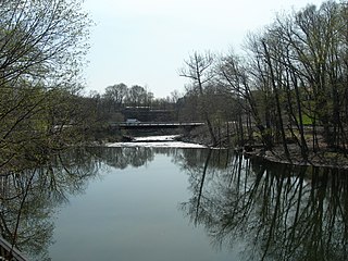
Red Hook is a village in Dutchess County, New York, United States. The population was 1,961 at the 2010 census. It is part of the Poughkeepsie–Newburgh–Middletown, NY Metropolitan Statistical Area as well as the larger New York–Newark–Bridgeport, NY-NJ-CT-PA Combined Statistical Area. The name is derived from the Dutch "Roode Hoeck" – hoeck meaning peninsula, and roode meaning red – a reference to the vibrant reds in the area's fall foliage.

Red Hook is a town in Dutchess County, New York, United States. The population was 9,953 at the time of the 2020 census, down from 11,319 in 2010. The name is supposedly derived from the red foliage on trees on a small strip of land on the Hudson River. The town contains two villages, Red Hook and Tivoli. The town is in the northwest part of Dutchess County.
Wingdale is a hamlet and census-designated place (CDP) in the town of Dover in Dutchess County, New York, United States. It was first listed as a CDP prior to the 2020 census.
New Hackensack is an unincorporated community and census-designated place (CDP) in the town of Wappinger in Dutchess County, New York, United States. It was first listed as a CDP prior to the 2020 census.

Freedom Plains is a hamlet and census-designated place (CDP) in Dutchess County, New York, United States. As of the 2010 census the population was 421.

Hyde Park is a hamlet and census-designated place (CDP) in the town of Hyde Park, Dutchess County, New York, United States. Its population was 1,908 as of the 2010 census.

Merritt Park is a census-designated place (CDP) in the town of Fishkill in Dutchess County, New York, United States. As of the 2010 census it had a population of 1,256.

Titusville is a hamlet and census-designated place in the town of LaGrange, New York, in Dutchess County, United States. As of the 2010 census, it had a population of 811.
Weston is a census-designated place (CDP) in the town of Weston, Fairfield County, Connecticut, United States. It comprises the center of town government and surrounding residential areas. The area was known as "Norfield" from 1795 to 1920, and the Norfield Historic District, which occupies the center of the CDP, around the intersection of Norfield Road and Weston Road, preserves the older name.
Chelsea Cove is a census-designated place (CDP) located in the town of Beekman in Dutchess County, New York, United States. It was first listed as a CDP prior to the 2020 census.
MacDonnell Heights is a census-designated place (CDP) in the town of Poughkeepsie in Dutchess County, New York, United States. It was first listed as a CDP prior to the 2020 census.
Shorehaven is a census-designated place (CDP) in the town of Pawling in Dutchess County, New York, United States. It was first listed as a CDP prior to the 2020 census.
Weston is the primary village and a census-designated place (CDP) in the town of Weston, Windsor County, Vermont, United States. As of the 2020 census, it had a population of 77, compared to 623 in the entire town.


