Orange is a town in New Haven County, Connecticut, United States. The population was 14,280 at the 2020 census. The town is governed by a Board of Selectmen.

The New Haven Green is a 16-acre (65,000 m2) privately owned park and recreation area located in the downtown district of the city of New Haven, Connecticut. It comprises the central square of the nine-square settlement plan of the original Puritan colonists in New Haven, and was designed and surveyed by colonist John Brockett. Today the Green is bordered by the modern paved roads of College, Chapel, Church, and Elm streets. Temple Street bisects the Green into upper (northwest) and lower (southeast) halves.

The Canterbury Center Historic District is a historic district in Canterbury, Connecticut. The district is centered on the town green, located at the junction of Route 169 and Route 14. It has been the town center since 1705, and includes a fine assortment of 18th and early 19th-century architecture. It was listed on the National Register of Historic Places (NRHP) in 1998.

The Chaplin Historic District in Chaplin, Connecticut is a historic district that was listed on the National Register of Historic Places (NRHP) in 1978. The district encompasses the historic village center of Chaplin, which extends for 0.8 miles (1.3 km) along Chaplin Street, and was most heavily developed in the early 19th century. The focal center of the district is the 1812-15 Congregational Church, which stands on a knoll overlooking the street. Most of the district's buildings are wood-frame houses, although the Witter House is a notable brick structure. Stylistically most of the houses are either Federal or Greek Revival in style. In addition to the church, other public buildings include the 1840 former town hall, the 1911 Colonial Revival Ross Memorial Library building, and Eaton's Store, built in 1850.

The South Britain Historic District encompasses the core of the unincorporated village of South Britain in Southbury, Connecticut, United States. The village arose in the 18th century as an industrial center serving the surrounding agricultural community, powered by the Pomperaug River, and rivalled the town center of Southbury in importance. It was listed on the National Register of Historic Places in 1987.
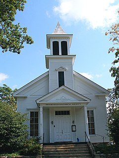
The Brookfield Center Historic District in Brookfield, Connecticut is a historic district that was listed on the National Register of Historic Places in 1991. It is located in the vicinity of the junction of Route 133 and Route 25. The district represents the original settlement of the town of Brookfield and contains 67 residential, religious, and municipal buildings over a 43-acre (17 ha) area representing a wide range of architectural styles from the 18th to 20th centuries including Bungalow/Craftsman, Greek Revival, and Queen Anne style architecture. The district includes the old town hall, the Congregational Church of Brookfield, Saint Joseph Church & Elementary School, Center Elementary School (Public), the former general store, St. Paul's Episcopal Church, and the surrounding residential neighborhood. The district is architecturally significant as an accurate representation of the historical development of the original settlement of the Town of Brookfield as the buildings are well-preserved from the time they were built with minimal alterations and intrusions, including their spatial relationships to one another.

Goshen Historic District is a historic district encompassing the town center village of Goshen, Connecticut. Centered at the junction of Connecticut Routes 4 and 63, the village developed historically as a rural crossroads of two turnpikes, and has retained its rural character. It is dominated by residential architecture from the first half of the 19th century, and includes churches, a store, and the town's former 1895 town hall. It was listed on the National Register of Historic Places in 1982.

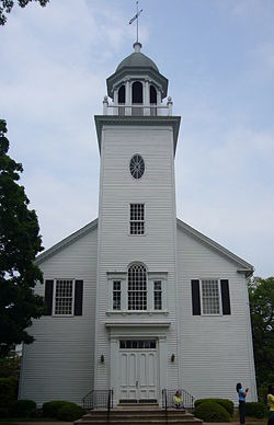
Norwichtown is a historic neighborhood in the city of Norwich, Connecticut. It is generally the area immediately north of the Yantic River between I-395 and Route 169.
The First Church Parsonage is a historic parsonage house at 160 Palisado Avenue in Windsor, Connecticut. Built in 1852 for the new minister of the First Congregational Church, it is a well-preserved example of transitional Greek Revival-Italianate architecture in brick. The house was listed on the National Register of Historic Places in 1988.

The Woodbridge Green Historic District is a historic district encompassing the historic town center of Woodbridge, Connecticut. It is located in the block bounded on the south by Center Road, on the east by Newton Road, and on the north and west by Meetinghouse Lane. The center is a good example of early 20th-century town planning, with good examples of Colonial and Classical Revival architecture. The district was added to the National Register of Historic Places in 2003.

The New Preston Hill Historic District encompasses a small rural 19th-century village center in the New Preston area of the town of Washington, in Litchfield County, Connecticut. Settled in the late 18th century, it is distinctive for its examples of stone architecture, include a rare Federal period stone church. The district, located at the junction of New Preston Road with Gunn Hill and Findlay Roads, was listed on the National Register of Historic Places in 1985.
The Southington Center Historic District is a National Register of Historic Places district covering a major portion of the center of Southington, Connecticut. The area includes a considerable number of resources, many of which are buildings, commercial, governmental, religious and residential, but the list also includes monuments, and the town green. The district was added to the National Register in 1989.
The Plymouth Center Historic District encompasses historic early village center of Plymouth, Connecticut. Stretching along Main, North and South Streets from their junction, it flourished in the 19th century with small-scale industries, but declined late in the century with the separation of Thomaston and the more significant industrial development at Terryville. The district features colonial, Federal, and Greek Revival architecture and was added to the National Register of Historic Places in 1999, with a slight enlargement the following year.
Bridgewater Center Historic District encompasses the traditional town center of Bridgewater, Connecticut. Centered at the junction of Main Street with Clapboard and Hat Shop Hill Roads, it developed in the early 19th century as a civic center, even before the town's 1856 incorporation from New Milford. The architecture of the center is largely reflective of the first half of the 19th century, including Greek Revival and Federal style buildings. It was listed on the National Register of Historic Places in 2000.

The Grafton Village Historic District encompasses the historic village center of the town of Grafton, Vermont. The village was developed in the early-to-mid 19th century, and has retained the character of that period better than many small communities in the state. The district was listed on the National Register of Historic Places in 2010.

The Chelsea Village Historic District encompasses the historic village center of Chelsea, Vermont, the shire town of Orange County. Developed in the first half of the 19th century as a regional service and transportation hub, the village exhibits a significant number of Greek Revival buildings, augmented with primarily later civic and commercial buildings. It was listed on the National Register of Historic Places in 1983.

The Randolph Center Historic District encompasses the historic early town center of Randolph, Vermont. Established in 1783, it was later eclipsed by Randolph Village, which developed around the town's main railroad depot. The village now has a distinguished array of late 18th and early 19th-century architecture, and is home to an academic campus now housing the Vermont Technical College. It was listed on the National Register of Historic Places in 1974.

The Treadwell House is a historic house at 253 Spielman Highway in the center of Burlington, Connecticut. Built about 1810 for John Treadwell, then the Governor of Connecticut, it is a distinctive local example of Federal period architecture with Greek Revival overlay features. It was listed on the National Register of Historic Places in 1982. It is now used for commercial purposes.

The Gill Center Historic District encompasses the historic 19th-century village center of Gill, Massachusetts. The district is focused on Main Road near its junction with River Road, in the central northern part of the town, and has served as the community's center since its incorporation in 1793. The district was listed on the National Register of Historic Places in 1999; it features a variety of mainly Greek Revival and later Victorian architecture, as well as some 20th-century Colonial Revival buildings.
Christ Episcopal Church is a historic Episcopal church located on the town green of Bethlehem, Connecticut. Founded as a parish early in the 19th century, it has been a central part of the life of the town ever since. The building is an outstanding example of Gothic Revival architecture, and its unique metal roof helps incorporate it visually with other historic buildings in the area around the green. Major renovations were designed by R. W. Hill, a noted Waterbury architect, early in his career. It also houses a Jardine tracker organ designed in 1855. Along with the First Congregational Church across the street and the Bellamy-Ferriday House on another side of the town green, Christ Episcopal Church helps anchor the historic center of this small rural town in Litchfield County, Connecticut.