
West Haven is a city in New Haven County, Connecticut, United States, and a coastal city of Long Island Sound. At the 2020 census, the population of the city was 54,070.

The New Haven Green is a 16-acre (65,000 m2) privately owned park and recreation area located in the downtown district of the city of New Haven, Connecticut. It comprises the central square of the nine-square settlement plan of the original Puritan colonists in New Haven, and was designed and surveyed by colonist John Brockett. Today the Green is bordered by the modern paved roads of college, Chapel, Church, and Elm streets. Temple Street bisects the Green into upper (northwest) and lower (southeast) halves.

Downtown New Haven is the neighborhood located in the heart of the city of New Haven, Connecticut. It is made up of the original nine squares laid out in 1638 to form New Haven, including the New Haven Green, and the immediate surrounding central business district, as well as a significant portion of the Yale University campus. The area includes many restaurants, cafes, theaters and stores. Downtown is bordered by Wooster Square to the east, Long Wharf to the southeast, the Hill neighborhood to the south, the Dwight neighborhood to the west, the Dixwell neighborhood to the northwest, the Prospect Hill area to the north, and East Rock to the northeast.

The history of West Haven, Connecticut: This article will be covering the colonial and revolutionary history, the economic history, Savin Rock Park, and the 20th century history of West Haven, Connecticut.
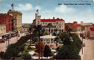
The Alamo Plaza Historic District is an historic district of downtown San Antonio in the U.S. state of Texas. It was listed on the National Register of Historic Places in 1977. It includes the Alamo, which is a separately listed Registered Historic Place and a U.S. National Historic Landmark.

The Whitney Avenue Historic District is a historic district in the East Rock neighborhood of New Haven, Connecticut. It is a 203-acre (82 ha) district which included 1,084 contributing buildings when it was listed on the National Register of Historic Places in 1989.

The Downtown North Historic District is a 19-acre (7.7 ha) historic district in Hartford, Connecticut. It is a predominantly residential area located around Main Street and High Street north of I-84 and south of the Amtrak railroad tracks. Its apartment blocks, houses, schools and churches, built up mainly in the late 19th and early 20th centuries as part of an expansion of the city's urban core. It includes the 130-foot (40 m) Keney Tower. The area was listed on the National Register of Historic Places in 2004.
The East Haven Green is the town green of the New England town of East Haven, Connecticut. It is bounded by River Street, Hemingway Avenue, Main Street, and Park Place and is the focal point of the East Haven Green Historic District, listed on the National Register of Historic Places. This area is also part of the commercial business district of the town and contains many two- and three-story brick office buildings that have been constructed within the last ten or fifteen years. Farther to the northwest are a shopping center and high-rise apartment buildings.

Wolcott Green Historic District a historic district in the New England town of Wolcott, Connecticut. The district encompasses the town green and the surrounding buildings. The green is located in the town center of Wolcott along Center Road. It has a triangular shape and is surrounded by several houses, a church and the town hall. The other streets bounding the green are Bound Line Road and Kenea Avenue.

The Pratt Street Historic District of Hartford, Connecticut, encompasses all of Pratt Street, between Main and Trumbull Streets, in the city's downtown. This block, which includes 15 buildings, is the only place in the city where its typical early 20th-century streetscape is retained. All of the buildings in the district were built between 1830 and 1928, a significant number of them designed by major local architects. The district was listed on the National Register of Historic Places in 1983.

The Chapel Street Historic District is a 23-acre (9.3 ha) historic district in the Downtown New Haven area of the city of New Haven, Connecticut. It was listed on the National Register of Historic Places in 1984. The district covers the southwestern corner of Downtown New Haven, including properties from Park Street to Temple Street between Chapel and Crown streets, and properties from High Street to Temple Street between George and Crown streets. It is bordered on the north by the New Haven Green and the Yale University campus. The western edge borders the Dwight Street Historic District. The eastern and southern edges of the district abut areas of more modern development.
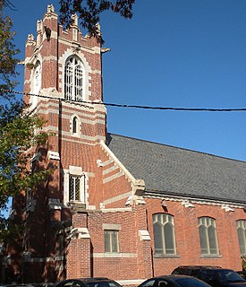
St. Luke's Episcopal Church is a historic church at 111-113 Whalley Avenue in New Haven, Connecticut. Built in 1905 for a congregation founded in 1844, it is a good example of late Gothic Revival architecture, and is further notable as the second church in the city established as an African-American congregation. It was listed on the National Register of Historic Places in 2003.

The Clinton Downtown Historic District is a historic district located in the village of Clinton in Clinton Township in the northernmost portion of Lenawee County, Michigan. It consists of most of the 100 block of U.S. Route 12, known locally as West Michigan Avenue, plus Memorial Park at 200 West Michigan. The district was added to the National Register of Historic Places on April 27, 2010.

The Downtown Waterbury Historic District is the core of the city of Waterbury, Connecticut, United States. It is a roughly rectangular area centered on West Main Street and Waterbury Green, the remnant of the original town commons, which has been called "one of the most attractive downtown parks in New England."

The Sixth and Forest Historic District is located in Des Moines, Iowa, United States. It is a Victorian era suburban commercial district on the northeastern and northwestern corners of the junction of 6th and Forest Avenues, and originally contained six buildings. The buildings on the northeast corner have subsequently been torn down. The historic district has been listed on the National Register of Historic Places since 1996. It is a part of the Towards a Greater Des Moines MPS.

The Winsted Green Historic District encompassing the historic town green of Winsted, Connecticut, and a collection of historic buildings that face it. It extends northward from the junction of United States Route 44 and Connecticut Route 8 to Holabird Avenue, and features a diversity of architecture from the early 19th to 20th centuries, reflecting the city's growth. The district was listed on the National Register of Historic Places in 1977, and slightly enlarged in 1982.

Gympie Memorial Park is a heritage-listed memorial at River Road, Gympie, Gympie Region, Queensland, Australia. It was designed by Harry Moore and Alfred Herbert Foster and built from 1919 to 1921. It was added to the Queensland Heritage Register on 18 September 2009.

The Central Avenue-Center Cemetery Historic District encompasses part of the town center of East Hartford, Connecticut. Although it was founded in the mid-17th century, it is now dominated by architecture of the late 19th and early 20th centuries. The Center Cemetery is the town's oldest surviving property, and includes the grave of William Pitkin, a colonial governor. The district, including portions of Main Street and Central Avenue, was listed on the National Register of Historic Places in 1993.

The South Green Historic District encompasses a predominantly 19th-century residential area near the South Green of Hartford, Connecticut. This area features a variety of residences in both high and common styles, from the elaborate home of armsmaker Samuel Colt to multi-unit apartment houses, many of which were built between about 1860 and 1900. The district is roughly triangular, extending from South Green along Main Street and Wethersfield Avenue to include Morris, Dean, and Alden Streets. The district was listed on the National Register of Historic Places in 1977.
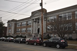
The Old West Haven High School is a historic former school building at 278 Main Street in West Haven, Connecticut. Built in 1926 during a period of rapid population growth, it served the city as a high school and then junior high school until 1983. It was designed by New Haven architect Roy Foote, and is a prominent local example of Classical Revival architecture. It was listed on the National Register of Historic Places. It now houses residences.


