
New Haven County is a county in the south central part of the U.S. state of Connecticut. As of the 2020 census, the population was 864,835, making it the third-most populous county in Connecticut. Two of the state's largest cities, New Haven (3rd) and Waterbury (5th), are part of New Haven County.
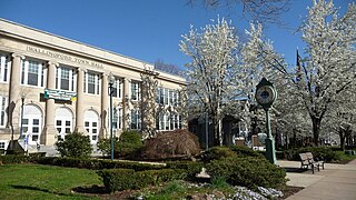
Wallingford is a town in New Haven County, Connecticut, United States, centrally located between New Haven and Hartford, and Boston and New York City. The population was 44,396 at the 2020 census. The community was named after Wallingford, in England.

White River Junction is an unincorporated village and census-designated place (CDP) in the town of Hartford in Windsor County, Vermont, United States. The population was 2,528 at the 2020 census, up from 2,286 in 2010, making it the largest community within the town of Hartford.

Meriden is a city in New Haven County, Connecticut, located halfway between the regional cities of New Haven and Hartford. In 2020, the population of the city was 60,850.

A single-point urban interchange, also called a single-point interchange (SPI) or single-point diamond interchange (SPDI), is a type of highway interchange. The design was created in order to help move large volumes of traffic through limited amounts of space safely and efficiently.

The Custis Trail is a hilly 4.5 miles (7.2 km)-long shared use path in Arlington County, Virginia. The asphalt-paved trail travels along Interstate 66 (I-66) between Rosslyn and the Washington & Old Dominion Railroad Trail at Bon Air Park.
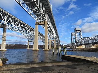
The Gold Star Memorial Bridge is a pair of steel truss bridges that carry both Interstate 95 and U.S. Route 1 across the Thames River between New London, Connecticut, US and Groton, Connecticut. The bridge is the largest structure in the state with more than 1,000,000 sq ft (93,000 m2) of deck area, and the longest bridge in the state at 6,000 feet (1,829 m). Its 11 highway lanes accommodate an average daily traffic of 117,000 vehicles. The bridge is actually a set of twin bridges, but they are generally spoken of using the singular "bridge;" the local media and residents refer to it as "The Goldstar".
Delaware Route 2 (DE 2) is a 10.81-mile-long (17.40 km) east–west state highway located in the northern part of New Castle County in the U.S. state of Delaware. It runs from DE 72 and DE 273 on the eastern edge of Newark east to DE 52 in Wilmington. Between Newark and Wilmington, the route is a four- to six-lane divided highway called Capitol Trail and Kirkwood Highway that passes through suburban areas, running through Marshallton, Prices Corner, and Elsmere. In Wilmington, DE 2 is routed along the one-way pair of Lincoln Street eastbound and Union Street westbound, passing through urban areas.

The Arrigoni Bridge, also known locally as the Portland Bridge is a steel through arch bridge carrying Route 66 and Route 17 across the Connecticut River, connecting Middletown, Connecticut to Portland, Connecticut. When it opened in 1938, the 1,200 feet (370 m) bridge was the most expensive bridge ever built in Connecticut, at a cost of $3.5 million. Its two distinctive 600 feet (180 m) steel arches have the longest span length of any bridge in the state. The bridge has an average daily traffic of 33,600.

Route 150 is a state highway in southern Connecticut running for 9.04 miles (14.55 km) from the village of Northford, in the town of North Branford, through the center of Wallingford, to the village of Yalesville in Wallingford.
The Oakdale Theatre is a multi-purpose performance venue, located in Wallingford, Connecticut. Opened in 1954, the venue consists of an auditorium and domed theatre, known as The Dome at Oakdale.
A roundabout interchange is a type of interchange between a controlled access highway, such as a motorway or freeway, and a minor road. The slip roads to and from the motorway carriageways converge at a single roundabout, which is grade-separated from the motorway lanes with bridges.

The Blackledge River is a tributary of the Salmon River which courses 16.4 miles (26.4 km) through eastern Connecticut in the United States.

The Hampden County Memorial Bridge is a reinforced-concrete arch bridge that spans the Connecticut River between Springfield, Massachusetts and West Springfield, Massachusetts, constructed in 1922. The bridge is owned by Massachusetts Highway Department and is located on Massachusetts Route 147. It spans 209 feet (64 m) and rises 29.71 feet (9.06 m) above the river.
The Meriden Linear Trail is a rail trail that follows the original route of the Meriden, Waterbury & Connecticut River Railroad through the city of Meriden, Connecticut. It follows 1.3 miles (2.1 km) of the former roadbed through the Quinnipiac River Gorge, starting at Red Bridge and ending near the Meriden/Cheshire town line. This portion of the Linear Trail system is named The Quinnipiac River Gorge Trail.

A skew arch is a method of construction that enables an arch bridge to span an obstacle at some angle other than a right angle. This results in the faces of the arch not being perpendicular to its abutments and its plan view being a parallelogram, rather than the rectangle that is the plan view of a regular, or "square" arch.
The 'Hancock Brook Trail' is a 2.8-mile (4.5 km) Blue-Blazed hiking trail Waterville Section of the City of Waterbury in New Haven County close to the borders of Thomaston and Plymouth, Litchfield County, Connecticut. It is contained overwhelmingly in a section of the Mattatuck State Forest bounded by Hancock Brook on the east, Thomaston Avenue on the west and Spruce Brook Road / Route 262 to the north.

The Thirty-third Street Bridge in Philadelphia carries Thirty-third Street over the former course of Master Street in the Brewerytown section of North Philadelphia, near Fairmount Park. The bridge was built in 1901 with an unusual skewed arch, and listed on the National Register of Historic Places in 1988. Ashlar, or dressed stone, covers the exterior of the arch, but the unusual skewed ribs are made of brick. The underpass is now inside an industrial area and normally closed even to foot traffic. The tracks of the former Pennsylvania Railroad are located just to the north and pass under a large modern bridge on Thirty-third Street.

The Stone Arch Underpass is a historic stone arch bridge spanning Glen Road in Lebanon, New Hampshire. Built about 1848, it carried the Boston and Maine Railroad's former Northern Line. It is one of a small number of 19th-century stone arch bridges in the state, and the only one known in central western New Hampshire. The bridge was listed on the National Register of Historic Places in 1985. The railroad right-of-way has been functionally abandoned, and the bridge may become part of a continuation of the Northern Rail Trail.

Cedar Hill Yard is a classification yard located in New Haven, North Haven, and Hamden, Connecticut. It was built by the New York, New Haven and Hartford Railroad in the early 1890s in and around New Haven's Cedar Hill neighborhood, which gave the yard its name. Electrical catenary for electric locomotives was added to the yard in 1914. To handle increasing traffic as a result of World War I, the yard was greatly expanded between 1917 and 1920 with additional construction along both sides of the Quinnipiac River. The construction project added two humps where railroads cars were sorted into trains by gravity. The yard was further modernized in the 1920s, becoming one of the busiest railroad yards in the United States, and the most important yard in the entire New Haven Railroad system.
