List of islands of California

Last updated

This list of islands of California is organized into sections, generally arranged from north to south. The islands within each section are listed in alphabetical order.

Contents

The Geographic Names Information System (GNIS) lists 527 named islands in the state. [1]

Humboldt County

Offshore

IslandImageCoordinatesDescription
Sugar Loaf Island South Cape Mendocino & Sugarloaf Island.jpeg 40°26′20″N124°24′50″W / 40.438767°N 124.413783°W / 40.438767; -124.413783 Sugar Loaf Island, offshore Cape Mendocino, rises 128 feet (39 m) above mean sea level. It is a special zone in the South Cape Mendocino State Marine Reserve and is closed to public access. [2] [3] Being offshore of Cape Mendocino, the westernmost point in California, Sugar Loaf Island is called the westernmost island in the state. [4]

Humboldt Bay

All three islands in Humboldt Bay are located in the narrow midsection of the bay. This portion of the bay is located within the City of Eureka, California entirely within Humboldt County.

IslandImageCoordinatesDescription
Daby Island 1852 U.S. Coast Survey Map of Humboldt Bay, California.jpg 40°48′41″N124°09′07″W / 40.8114°N 124.151837°W / 40.8114; -124.151837 The smallest of the three islands within Humboldt Bay, Daby Island has a maximum elevation of 3 feet (0.91 m) and is located slightly northeast of Woodley Island.
Tuluwat Island Indian Island Tolowot California.jpg 40°48′46″N124°10′06″W / 40.8129°N 124.1684°W / 40.8129; -124.1684 (Indian Island) The largest island, 1.3 miles (2.1 km) long, was originally the center of culture and population of the indigenous Wiyot people. Now protected, no public access is allowed, except for the Wiyot and grandfathered residents.
Woodley Island 1852 U.S. Coast Survey Map of Humboldt Bay, California.jpg 40°48′34″N124°09′38″W / 40.809516°N 124.160549°W / 40.809516; -124.160549 The second largest of the three islands within Humboldt Bay contains: the Woodley Island Marina (Eureka's largest marina), the Eureka regional office of the National Weather Service, and offices of the Humboldt Bay Harbor Recreation & Conservation District.

Northern California

IslandImageCoordinatesCountiesDescription
Bird Rock BirdRock3339.jpg 38°13′48″N122°59′40″W / 38.2299°N 122.9944°W / 38.2299; -122.9944 (Bird Rock) [5] MarinSmall Pacific island west of Tomales Point, primarily a seabird colony. It covers 2 acres (0.81 ha).
Hog Island (Tomales Bay) Hog Island, Tomales Bay, Marin County, California.jpg 38°11′50″N122°56′09″W / 38.1971°N 122.9358°W / 38.1971; -122.9358 (Hog Island (Tomales)) MarinA 2-acre (0.81 ha) island in Tomales Bay.
Año Nuevo Island Ano Nuevo Island.jpg 37°06′31″N122°20′16″W / 37.1086°N 122.3378°W / 37.1086; -122.3378 (Año Nuevo Island) [6] San MateoSmall Pacific island, about 0.2 miles (0.32 km) long, near Año Nuevo (New Year's) Point, south of the Golden Gate. It is protected by the Año Nuevo State Reserve as an important habitat for seabirds and other coastal wildlife.

San Francisco Bay Area

For the Farallon Islands, see § Farallon Islands, below. For islands in the Sacramento River Delta, see § Sacramento–San Joaquin River Delta, below. For islands in Suisun Bay, see § Suisun Bay, below.

Other islands of the San Francisco Bay Area:

IslandImageCoordinatesCountiesDescription
Alameda Island Oakland California aerial view.jpg 37°45′55″N122°14′30″W / 37.76528°N 122.24167°W / 37.76528; -122.24167 (Alameda Island) Alameda, San Francisco (small, uninhabited sliver)This 6-mile (9.7 km) long island in San Francisco Bay is the main part of the City of Alameda.
Alcatraz Island Alcatraz Island 1, SF, CA, jjron 25.03.2012.jpg 37°49′36″N122°25′24″W / 37.8266°N 122.4233°W / 37.8266; -122.4233 (Alcatraz Island) San FranciscoThis 22-acre (8.9 ha) island in San Francisco Bay once served as a lighthouse, a military fortification, a military prison, and as a federal prison until 1963. It is now part of the Golden Gate National Recreation Area.
Angel Island Angel Island (40280).jpg 37°51′46″N122°25′51″W / 37.862778°N 122.430833°W / 37.862778; -122.430833 (Angel Island) Marin, San Francisco (small, uninhabited slivers)With an area of 1.2 square miles (3.1 km2), this island in San Francisco Bay processed approximately 1 million immigrants to the U.S. during 1910 to 1940. It is currently a state park.
Bair Island Bair Island aerial.jpg 37°31′48″N122°13′20″W / 37.5299°N 122.2222°W / 37.5299; -122.2222 (Bair Island) San MateoThis 2,600-acre (1,100 ha) island in San Francisco Bay near Redwood City is part of the Don Edwards San Francisco Bay National Wildlife Refuge.
Bay Farm Island Aerial view of Bay Farm Island and San Leandro Channel.jpg 37°44′17″N122°15′07″W / 37.738°N 122.252°W / 37.738; -122.252 (Bay Farm Island) AlamedaThis former island in San Francisco Bay has been connected to the mainland. It is part of the City of Alameda.
Belvedere Island Belvedere, California in 2010.jpg 37°52′18″N122°28′07″W / 37.8716°N 122.4685°W / 37.8716; -122.4685 (Belvedere Island) MarinThis former island in Richardson Bay has been connected to the mainland. It is part of the City of Belvedere.
Bird Island Birdisland.jpg 37°49′27″N122°32′12″W / 37.8241°N 122.5366°W / 37.8241; -122.5366 (Bird Island) [7] MarinSmall Pacific island between Point Bonita and Rodeo Cove.
Brooks Island Brooks Island from SS Red Oak Victory, 2014 04 13.jpg 37°53′47″N122°21′19″W / 37.89639°N 122.35528°W / 37.89639; -122.35528 (Brooks Island) Contra CostaA 65-acre (26 ha) island in San Francisco Bay south of Richmond, protected as part of the Brooks Island Regional Shoreline.
The Brothers Brothers-islands.jpg 37°57′48″N122°25′59″W / 37.96333°N 122.43306°W / 37.96333; -122.43306 (Brother Islands) Contra CostaTwo small islands, East Brother and West Brother, located west of Point San Pablo. Each is about 300 feet (91 m) long. East Brother has a lighthouse and a bed and breakfast.
Castro Rocks Castro Rocks from the water.jpg 37°55′56″N122°25′07″W / 37.93222°N 122.41861°W / 37.93222; -122.41861 (Castro Rocks) Contra CostaBeneath the Richmond–San Rafael Bridge.
Coast Guard Island Coast Guard Island May 2009.jpg 37°46′56″N122°15′00″W / 37.78222°N 122.25000°W / 37.78222; -122.25000 (Coast Guard Island) AlamedaLocated in the Oakland Estuary, this 67-acre (27 ha) artificial island is part of the City of Alameda. It is home to various United States Coast Guard facilities.
Corinthian Island 37°52′22″N122°27′32″W / 37.87278°N 122.45889°W / 37.87278; -122.45889 (Corinthian Island) MarinThis former island was joined to the mainland in the 1980s. It is split between the city of Belvedere and the town of Tiburon.
East Marin Island Marin islands1.JPG 37°57′52″N122°28′06″W / 37.96444°N 122.46833°W / 37.96444; -122.46833 (East Marin Island) MarinNear San Rafael, California. Pictured on the right in the image.
Greco Island Pacific Shores Center 09 of 23.jpg 37°31′04″N122°10′59″W / 37.5177146°N 122.1830205°W / 37.5177146; -122.1830205 (Greco Island) San MateoThis 817 acres (331 ha) island in San Francisco Bay near Redwood City is part of the Don Edwards San Francisco Bay National Wildlife Refuge.
Gull Rock 37°52′34″N122°36′59″W / 37.8760°N 122.6164°W / 37.8760; -122.6164 (Gull Rock) MarinA Pacific island near Mount Tamalpais, about 200 feet (61 m) long.
Hog Island (Petaluma River) 38°09′33″N122°32′18″W / 38.1591°N 122.5383°W / 38.1591; -122.5383 (Hog Island (Petaluma)) SonomaIsland in the Petaluma River wetlands.
Hooks Island Hooks Island California crop.jpg 37°27′22″N122°05′49″W / 37.456°N 122.097°W / 37.456; -122.097 (Hooks Island) Santa Clara36-acre (15 ha) tidal salt marsh island [8] in the Palo Alto Baylands Nature Preserve
Kent Island Kent Island 3420.jpg 37°54′44″N122°40′43″W / 37.9121°N 122.6786°W / 37.9121; -122.6786 (Kent Island) MarinAn island in Bolinas Lagoon, near the town of Bolinas. About 0.5 miles (0.80 km) long.
Mare Island Wfm mare island aerial.jpg 38°05′44″N122°16′21″W / 38.0955°N 122.2725°W / 38.0955; -122.2725 (Mare Island) SolanoAn island in San Pablo Bay near Vallejo. About 3.5 miles (5.6 km) long, site of a major shipyard.
Mussel Rock Mussel Rock.jpg 37°40′01″N122°29′50″W / 37.6669°N 122.4972°W / 37.6669; -122.4972 (Mussel Rock) San MateoA stack in the Pacific Ocean near Daly City. About 200 feet (61 m) long.
Rat Rock Rat Rock 3655.jpg 38°00′16″N122°27′43″W / 38.00444°N 122.46194°W / 38.00444; -122.46194 (Rat Rock) MarinAn 18-foot (5.5 m) tall rock north of China Camp.
Red Rock Island Red-rock-island.jpg 37°55′45″N122°25′51″W / 37.92917°N 122.43083°W / 37.92917; -122.43083 (Red Rock Island) Contra Costa, Marin and San FranciscoThis uninhabited 5.8-acre (2.3 ha) island is located in San Francisco Bay just south of the Richmond–San Rafael Bridge, near the meeting point of three counties. It is privately owned.
San Pedro Rock San Pedro Rock Trail.jpg 37°35′43″N122°31′27″W / 37.5952°N 122.5241°W / 37.5952; -122.5241 (San Pedro Rock) San MateoA Pacific island near the city of Pacifica. About 800 feet (240 m) long.
Seal Rocks (San Francisco, California) Seal Rocks and Cliff House big.jpg 37°46′43″N122°30′58″W / 37.77861°N 122.51611°W / 37.77861; -122.51611 (Seal Rock) San FranciscoA series of large rocks in the Pacific Ocean that host a sea lion colony.
Seal Rock (San Mateo County, California) 37°23′30″N122°25′29″W / 37.3916°N 122.4247°W / 37.3916; -122.4247 (Seal Rock) San MateoA Pacific island south of Half Moon Bay, about 500 feet (150 m) long.
The Sisters The Sisters 3647.jpg 37°59′18″N122°26′28″W / 37.9883°N 122.4411°W / 37.9883; -122.4411 (The Sisters) MarinA pair of small islands in San Pablo Bay, 2,000 feet (610 m) south of Point Saint Pedro.
Treasure Island Wfm yerba buena treasure islands usgs.jpg 37°49′29″N122°22′16″W / 37.82472°N 122.37111°W / 37.82472; -122.37111 (Treasure Island) San FranciscoThis 403-acre (163 ha) artificial island in San Francisco Bay is tied to Yerba Buena Island. It was dredged out of the bay to house the Golden Gate International Exposition of 1939-40.
West Marin Island Marin islands1.JPG 37°57′57″N122°28′22″W / 37.96583°N 122.47278°W / 37.96583; -122.47278 (West Marin Island) MarinNear San Rafael, California. Pictured on the left in the image.
Newby Island 37°27′32.1″N121°56′38.54″W / 37.458917°N 121.9440389°W / 37.458917; -121.9440389 (Newby Island) Santa ClaraNear Alviso, San Jose.
Ogilvie Island NASA Worldwind, USGS imagery map, Ogilvie Island, California.png 37°27′55″N122°00′37″W / 37.46528°N 122.01028°W / 37.46528; -122.01028 (Ogilvie Island) Santa ClaraNear Alviso, San Jose.
Yerba Buena Island Yerba Buena Island 4017.jpg 37°48′36″N122°21′58″W / 37.81000°N 122.36611°W / 37.81000; -122.36611 (Yerba Buena Island) San FranciscoThis island in San Francisco Bay is home to a Coast Guard station. The San Francisco–Oakland Bay Bridge passes through it by means of a tunnel.

Farallon Islands

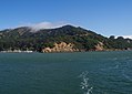
The Farallon Islands are a group of rugged small islands over 20 miles (32 km) offshore from the mainland of the City and County of San Francisco, which they are also formally within. They consist of over twenty small islets divided into north, south and middle sections, as well as a major bank, Fanny Shoal. The surrounding waters were once used as a disposal site for radioactive waste. [9]

IslandImageCoordinatesDescription
Aulone Island and Great Arch Rock Aulon arch Sugarloaf.JPG 37°42′08″N123°00′15″W / 37.7023°N 123.0042°W / 37.7023; -123.0042 (Aulon Island) North of Southeast Farallon Island, measuring 200 feet (61 m) wide and 400 feet (120 m) long.
Drunk Uncle Islets Group of small islets north of Maintop Island.
Farallón Viscaíno
Middle Farallon Island 37°43′38″N123°01′56″W / 37.7272°N 123.0322°W / 37.7272; -123.0322 (Middle Farallon) Medium-sized islet 1.8 miles (2.9 km) northwest of Southeast Farallon Island. It is 210 feet (64 m) long and has an area of 0.8 acres (0.32 ha).
North Farallon Island 37°45′44″N123°05′53″W / 37.7622°N 123.0981°W / 37.7622; -123.0981 (North Farallon) Medium-sized islet 500 feet (150 m) long and 100 feet (30 m) high, covering 2 acres (0.81 ha).
Peñasco Quebrado
Piedra Guadalupe
Island of St. James 37°46′00″N123°06′05″W / 37.7666°N 123.1014°W / 37.7666; -123.1014 (Island of Saint James) Medium-sized islet 3 acres (1.2 ha) in size, measuring 410 feet (120 m) long and 154 feet (47 m) high.
Sea Lion Rock 37°42′10″N123°00′19″W / 37.7029°N 123.0054°W / 37.7029; -123.0054 (Sea Lion Rock) Small islet northwest of Aulon Island, about 130 feet (40 m) long.
Seal Rock 37°41′38″N123°00′12″W / 37.6938°N 123.0033°W / 37.6938; -123.0033 (Seal Rock) Small islet south of Southeast Farallon Island, with a maximum height of 82 feet (25 m).
Maintop Island SE Farallon Island.jpg 37°41′57″N123°00′40″W / 37.6991°N 123.0111°W / 37.6991; -123.0111 (Maintop Island) West of Southeast Farallon Island, and has a maximum height of 223 feet (68 m).
Southeast Farallon Island View from Mirounga Bay.jpg 37°41′50″N123°00′11″W / 37.6972°N 123.0031°W / 37.6972; -123.0031 (Southeast Farallon) Is the largest of the Farallons, covering 0.19 square miles (0.49 km2). It is the only inhabited Farallon Island, and is also the site of Farallon Island Light.
Sugarloaf Island 37°42′13″N123°00′12″W / 37.7035°N 123.0032°W / 37.7035; -123.0032 (Sugarloaf Island) Directly to the northeast of Aulone and Great Arch Rock, about 80 feet (24 m) high.

Suisun Bay and Sacramento–San Joaquin River delta

Suisun Bay

Suisun Bay is an arm of the San Francisco Bay estuary which connects the Sacramento and San Joaquin rivers to the Carquinez Strait.

IslandImageCoordinatesCountyDescription
Chipps Island Nasaworldwind-usgsimagerytopobasemap-CHIPPSISLAND.png 38°03′19″N121°54′43″W / 38.0552°N 121.9119°W / 38.0552; -121.9119 (Chipps Island) Solano
Dutton Island NASA Worldwind, USGS imagery map, Dutton Island, California.png 38°04′54″N121°58′14″W / 38.0816°N 121.9705°W / 38.0816; -121.9705 (Dutton Island) Solano
Freeman Island Aerial view of Joice Island in California 1 cropped to ryer roe freeman and snag islands.JPG 38°04′46″N121°59′09″W / 38.0794°N 121.9858°W / 38.0794; -121.9858 (Freeman Island) SolanoSmall island, second from top on left hand of frame.
Grizzly Island Nasaworldwind-usgsimagerytopobasemap-grizzly-hammond-simmons-chipps-completemess.png 38°09′05″N121°58′22″W / 38.1513°N 121.9727°W / 38.1513; -121.9727 (Grizzly Island) Solano
Hammond Island 38°06′18″N121°56′15″W / 38.1049°N 121.9375°W / 38.1049; -121.9375 (Hammond Island) Solano
Joice Island Aerial view of Joice Island in California 1 cropped.jpg 38°09′00″N122°03′34″W / 38.1499°N 122.0594°W / 38.1499; -122.0594 (Joice Island) SolanoA marshy island 6 miles (9.7 km) long, north of Grizzly Bay.
Morrow Island Morrow Island (California).png 38°07′00″N122°05′11″W / 38.1166°N 122.0864°W / 38.1166; -122.0864 (Morrow Island) SolanoA small island that has an elevation of 2 meters- 7 feet.
Roe Island Aerial view of Joice Island in California 1 cropped to ryer roe freeman and snag islands.JPG 38°04′21″N122°02′05″W / 38.0724°N 122.0347°W / 38.0724; -122.0347 (Roe Island) SolanoIn Suisun Bay. On far right of picture (partially out of frame).
Ryer Island Aerial view of Joice Island in California 1 cropped to ryer roe freeman and snag islands.JPG 38°04′58″N122°00′52″W / 38.0827°N 122.0144°W / 38.0827; -122.0144 (Ryer Island) Solano475-hectare (1,170-acre) island, between Suisun Bay and Suisun Cutoff. [10] About 2 miles (3.2 km) long. Largest island in the photo.
Seal Islands 38°03′20″N122°02′50″W / 38.0555°N 122.0472°W / 38.0555; -122.0472 (Seal Islands) Contra CostaIn Suisun Bay.
Simmons Island NASA Worldwind, USGS imagery map, Simmons Island, California.png 38°05′49″N121°59′26″W / 38.0969°N 121.9905°W / 38.0969; -121.9905 (Simmons Island) Solano
Snag Island Aerial view of Joice Island in California 1 cropped to ryer roe freeman and snag islands.JPG 38°04′22″N121°58′32″W / 38.0727°N 121.9755°W / 38.0727; -121.9755 (Snag Island) SolanoSmallest island in the photo, top center.
Van Sickle Island USGS Aerial imagery of Van Sickle Island, California.png 38°04′00″N121°54′04″W / 38.0666°N 121.9011°W / 38.0666; -121.9011 (Van Sickle Island) SolanoAn island 2.5 miles (4.0 km) long at the junction of the Sacramento River, San Joaquin River, and Suisun Bay.
Wheeler Island NASA Worldwind, USGS imagery map, Wheeler Island, California.png 38°05′06″N121°56′15″W / 38.0849°N 121.9375°W / 38.0849; -121.9375 (Wheeler Island) Solano

Sacramento–San Joaquin River Delta

The Sacramento–San Joaquin River Delta is an inverted delta at the juncture of the Sacramento and San Joaquin rivers. There are about 57 named islands in the Delta.

IslandImageCoordinatesCountyDescription
Andrus Island Andrus Island (California) Highlighted.png 38°09′28″N121°35′54″W / 38.1577°N 121.5983°W / 38.1577; -121.5983 (Andrus Island) Sacramento3,000-hectare (7,400-acre) island, bounded by Sacramento River, Georgiana Slough, Mokelumne River, San Joaquin River, Jackson Slough, and Seven Mile Slough.
Bacon Island Bacon Island (California).png 37°58′36″N121°33′08″W / 37.9766°N 121.5522°W / 37.9766; -121.5522 (Bacon Island) San Joaquin2,200-hectare (5,400-acre) island, bounded by Connection Slough, Old River, Woodward Island, and Middle River
Bethel Island NASA Worldwind, USGS imagery map, Jersey Island and Bethel Island, California.png 38°01′53″N121°38′27″W / 38.0313°N 121.6408°W / 38.0313; -121.6408 (Bethel Island) Contra Costa1,450-hectare (3,600-acre) island, bounded by Taylor Slough, Piper Slough, Sand Mound Slough, and Dutch Slough
Bishop Tract
Brack Tract
Byron Tract
Bouldin Island Bouldin Island (California).png 38°06′15″N121°32′05″W / 38.1041°N 121.5347°W / 38.1041; -121.5347 (Bouldin Island) San Joaquin2,400-hectare (5,900-acre) island bounded by South Mokelumne River, Little Potato Slough, Potato Slough, and Mokelumne River.
Bradford Island NASA Worldwind, USGS imagery map, Bradford Island, California.png 38°04′38″N121°39′48″W / 38.0771°N 121.6633°W / 38.0771; -121.6633 (Bradford Island) Contra Costa
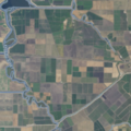
885-hectare (2,190-acre) island in the lower delta bounded by the San Joaquin River, False River and the Bradford Island canal/slough. Accessible only by Ferry via Jersey Island, just south of it.
Browns Island Antioch aerial view, August 2018 cropped.jpg 37°57′37″N121°21′21″W / 37.9602°N 121.3558°W / 37.9602; -121.3558 (Browns Island) Contra Costa275-hectare (680-acre) island, bounded by Middle Slough, New York Slough, and Suisun Bay. On the left in photo.
Canal Ranch Tract
Coney Island NASA Worldwind, USGS imagery map, Coney Island, California.png 37°50′45″N121°32′58″W / 37.8457598°N 121.5493939°W / 37.8457598; -121.5493939 (Coney Island) Contra Costa
Dead Horse Island Dead Horse Island, California.png 38°13′45″N121°30′08″W / 38.2290821°N 121.5021750°W / 38.2290821; -121.5021750 (Dead Horse Island) Sacramento
Decker Island Islands, Sacramento River Delta, California.jpg 38°05′26″N121°43′09″W / 38.0904745°N 121.7191214°W / 38.0904745; -121.7191214 (Decker Island) SolanoSmall island on the top-left in photo.
Empire Tract
Fabian Tract
Fay Island NASA Worldwind, USGS imagery map, Fay Island, California.png 37°56′55″N121°33′55″W / 37.9485348°N 121.5652291°W / 37.9485348; -121.5652291 (Fay Island) San Joaquin
Glanville Tract
Grand Island Grand Island (California).png 38°14′08″N121°34′45″W / 38.23556°N 121.57917°W / 38.23556; -121.57917 (Grand Island) Sacramento
Hastings Tract
Holland Tract
Hotchkiss Tract
Jersey Island JerseyIsland-1.jpg 38°02′11″N121°41′09″W / 38.0363°N 121.6858°W / 38.0363; -121.6858 (Jersey Island) Contra Costa1,425-hectare (3,520-acre) island, bounded by False River, Piper Slough, Taylor Slough, Dutch Slough and San Joaquin River.
Jones Tract Jones-tract.png upper: 37°55′12″N121°28′35″W / 37.9199°N 121.4763°W / 37.9199; -121.4763 (Upper Jones Tract)
lower: 37°57′16″N121°29′38″W / 37.9544°N 121.4938°W / 37.9544; -121.4938 (Lower Jones Tract) (lower)
San Joaquin
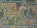
4,900-hectare (12,000-acre) island (tracts, Upper- and Lower-), bounded by Empire Cut, Whiskey Slough, Trapper Slough, and Middle River, 10 km east of Stockton
King Island King Island (California).png 38°03′56″N121°26′12″W / 38.0655°N 121.4366°W / 38.0655; -121.4366 (King Island) San Joaquin1,300-hectare (3,200-acre) island bounded by White Slough, Bishop Cut, Disappointment Slough, and Honker Cut
Kings Island Kings Island and others (California).png 37°51′29″N121°34′08″W / 37.8580°N 121.5688°W / 37.8580; -121.5688 (Kings Island) Contra Costa3.5-hectare (8.6-acre) island in Old River
Little Mandeville Island Little Mandeville Island (California).png 38°00′38″N121°33′54″W / 38.0104776°N 121.5649522°W / 38.0104776; -121.5649522 (Little Mandeville Island) San Joaquin
Little Tinsley Island
Mandeville Island Mandeville Island (California).png 38°02′05″N121°32′56″W / 38.03472°N 121.54889°W / 38.03472; -121.54889 San Joaquin
McDonald Island McDonald Island (California).png 38°00′05″N121°29′24″W / 38.0013°N 121.4900°W / 38.0013; -121.4900 (McDonald Island) San Joaquin2,400-hectare (5,900-acre) island, bounded by San Joaquin River, Middle River, Latham Slough, and Empire Cut.
Medford Island Medford Island, California.png 38°02′14″N121°30′41″W / 38.0371435°N 121.5113407°W / 38.0371435; -121.5113407 (Medford Island) San Joaquin
Merritt Island 38°21′19″N121°33′01″W / 38.3554°N 121.5503°W / 38.3554; -121.5503 (Merritt Island) YoloA 5,000 acres (2,000 ha) island formed by the Sacramento River to the southeast and Elk Slough to the west, located directly across the Sacramento from Hood.
Mildred Island Mildred-island-lol-its-like-completely-gone.png 37°59′11″N121°31′23″W / 37.9863117°N 121.5230069°W / 37.9863117; -121.5230069 (Mildred Island) San Joaquin
Netherlands Island
Neville Island
New Hope Tract
Orwood Tract
Palm Tract
Pierson District
Prospect Island Prospect Island (California).png 38°14′47″N121°39′56″W / 38.2463030°N 121.6655110°W / 38.2463030; -121.6655110 (Prospect Island) Solano
Quimby Island Quimby Island, California.png 38°01′31″N121°34′17″W / 38.0251993°N 121.5713413°W / 38.0251993; -121.5713413 (Quimby Island) Contra Costa
Rhode Island 37°59′59″N121°34′31″W / 37.9996445°N 121.5752300°W / 37.9996445; -121.5752300 (Rhode Island) Contra Costa
Rindge Tract
Rio Blanco Tract
Roberts Island Roberts Island (California).png 37°54′18″N121°23′07″W / 37.9049250°N 121.3852250°W / 37.9049250; -121.3852250 (Roberts Island) San Joaquin
Ruff and Ready Island San Joaquin River An approximately 2.3-square-mile island in Stockton, California. A United States Navy installation built there during World War II was phased out in 1995 and later transferred to the Port of Stockton.
Ryer Island Ryer Island (California).png 38°14′26″N121°38′03″W / 38.2405°N 121.6341°W / 38.2405; -121.6341 (Ryer Island) Solano4,750-hectare (11,700-acre), bounded by Miner Slough and Steamboat Slough.
Sargent Barhart Tract
Sherman Island Sherman Island, Sacramento River Delta (6744794921).jpg 38°03′34″N121°44′00″W / 38.0594°N 121.7333°W / 38.0594; -121.7333 (Sherman Island) Sacramento5,500-hectare (14,000-acre) island bounded by the Sacramento River, Three Mile Slough, and the San Joaquin River.
Shima Tract
Shin Kee Tract
Staten Island Staten Island (California).png 38°09′52″N121°30′59″W / 38.1644°N 121.5163°W / 38.1644; -121.5163 (Staten Island) San Joaquin3,700-hectare (9,100-acre) island bounded and flanked by the North Mokelumne River and South Mokelumne River.
Stewart Tract
Sutter Island NASA Worldwind, USGS imagery map, Sutter Island, California.png 38°17′29″N121°35′35″W / 38.2913°N 121.5930°W / 38.2913; -121.5930 (Sutter Island) SacramentoFormed by Sacramento River to the northeast, Steamboat Slough to the southeast, and Sutter Slough to the west. Located across the Sacramento River from Paintersville.
Sycamore Island
Terminous Tract
Twitchell Island Twitchell Island emergency exercise (15422438379).jpg 38°06′35″N121°38′55″W / 38.1096°N 121.6486°W / 38.1096; -121.6486 (Twitchell Island) Sacramento3,000-hectare (7,400-acre), bounded by Seven Mile Slough, San Joaquin River, and Three Mile Slough
Tyler Island Tyler Island (California).png 38°10′23″N121°32′51″W / 38.1729725°N 121.5474531°W / 38.1729725; -121.5474531 (Tyler Island) Sacramento
Union Island Union Island (California).png 37°50′15″N121°30′56″W / 37.8374268°N 121.5155042°W / 37.8374268; -121.5155042 (Union Island) San Joaquin
Van Sickle Island USGS Aerial imagery of Van Sickle Island, California.png 38°04′00″N121°54′04″W / 38.06667°N 121.90111°W / 38.06667; -121.90111 (Van Sickle Island) Solano
Veale Tract
Venice Island Venice Island, California.png 38°04′30″N121°32′04″W / 38.0749°N 121.5344°W / 38.0749; -121.5344 (Venice Island) San Joaquin1,250-hectare (3,100-acre) island bounded by Potato Slough, Little Connection Slough, Stockton Deepwater Channel Venice Cut, and San Joaquin River.
Victoria Island Victoria Island (California).png 37°53′24″N121°32′05″W / 37.8899°N 121.5347°W / 37.8899; -121.5347 (Victoria Island) San Joaquin2,900-hectare (7,200-acre) island bounded by North Victoria Canal, Middle River, Victoria Canal, and Old River.
Webb Tract
West Island Sherman Island, Sacramento River Delta (6744794921).jpg 38°01′24″N121°46′43″W / 38.0233°N 121.7786°W / 38.0233; -121.7786 (West Island) Sacramento
Winter Island Antioch aerial view, August 2018 cropped.jpg 38°02′32″N121°50′55″W / 38.0421°N 121.8486°W / 38.0421; -121.8486 (Winter Island) Contra CostaOn the right in photo.
Woodward Island Woodward Island (California).png 37°55′42″N121°32′46″W / 37.9283°N 121.5461°W / 37.9283; -121.5461 (Woodward Island) San Joaquin725-hectare (1,790-acre) island bounded by Bacon Island, Old River, Middle River, and Woodward Canal
Wright-Elmwood Tract

Channel Islands

The Channel Islands are a group of eight main islands and several minor islands in the Pacific Ocean off the coast of Santa Barbara, Los Angeles, and Ventura counties in Southern California. The four northern islands are protected in Channel Islands National Park, while two are used by the U.S. Navy. These Islands are part of the Greater Los Angeles Area.

IslandImageCoordinatesDescription
Anacapa Island West-anacapa.jpg 34°00′16″N119°23′59″W / 34.0045°N 119.3996°W / 34.0045; -119.3996 (Anacapa Island) [11] Located 14 miles (23 km) off the coast of Ventura, California. It contains 728 acres (295 ha) of land spread across three mountainous islets. The island has only three permanent residents. Part of the Greater Los Angeles Area.
Begg Rock 33°21′45″N119°41′52″W / 33.36250°N 119.69778°W / 33.36250; -119.69778 (Begg Rock) [12] A 15-foot (4.6 m) high rock, located 8 miles (13 km) from San Nicolas Island.
Prince Island 34°03′29″N120°20′01″W / 34.05806°N 120.33361°W / 34.05806; -120.33361 (Prince Island) Located near San Miguel Island and measures about 35 acres (14 ha).
San Clemente Island San-clemente-island.jpg 32°54′00″N118°30′03″W / 32.9000°N 118.5009°W / 32.9000; -118.5009 (San Clemente Island) [13] Southernmost Channel Island, containing 56.81 square miles (147.1 km2) of land. It is 24 miles (39 km) long, and uninhabited. An active U.S. Navy base is located on the island. In Los Angeles County.
San Juan Island San Juan Island on Tallis Map.jpg 32°28′41″N119°12′54″W / 32.478°N 119.215°W / 32.478; -119.215 (San Juan Island) [14] Historical San Juan Island, modern Cortes Bank, is a high seamount, an island submerged 6 feet and more, 96 mi SW of San Pedro, 111 mi (166 km) W of Pt Loma, and 47 mi (82 km) SW of San Clemente Island. The outermost feature in the Channel Islands, it has been visible as an island from elevations on San Clemente Island on clear days, and known for some of the world’s largest surf. Offshore from Orange County.
San Miguel Island San-miguel-cuyler-hike.jpg 34°02′23″N120°22′31″W / 34.0397°N 120.3754°W / 34.0397; -120.3754 (San Miguel Island) [15] Westernmost Channel Island, measuring 8 miles (13 km) long, 3.7 miles (6.0 km) wide, and containing 9,325 acres (3,774 ha) of land. The island is uninhabited, and is rarely visited. Part of the Greater Los Angeles Area.
San Nicolas Island 33°14′58″N119°30′01″W / 33.2495°N 119.5004°W / 33.2495; -119.5004 (San Nicolas Island) [16] Is said to be the most remote island of the Channel Islands, and is used by the U.S. Navy as a weapons testing and training facility. It has no civilian inhabitants, but is inhabited by military personnel. It covers 14,562 acres (5,893 ha). Part of the Greater Los Angeles Area.
Santa Barbara Island Santabarbara 300.jpg 33°28′32″N119°02′10″W / 33.4756°N 119.0362°W / 33.4756; -119.0362 (Santa Barbara Island) [17] Smallest Channel Island at 640 acres (260 ha) in area; it is located roughly between San Nicolas and Santa Catalina Islands. Part of the Greater Los Angeles Area.
Santa Catalina Island Lightmatter Avalon Bay.jpg 33°23′00″N118°25′03″W / 33.3834°N 118.4176°W / 33.3834; -118.4176 (Santa Catalina Island) [18] The most populous of the Channel Islands, with 3,696 residents as of 2000. It is about 22 miles (35 km) long with a maximum width of 8 miles (13 km). It covers 74.98 square miles (194.2 km2). In Los Angeles County.
Santa Cruz Island Santacruz 300.jpg 34°02′25″N119°50′37″W / 34.0403°N 119.8437°W / 34.0403; -119.8437 (Santa Cruz Island) [19] Santa Cruz Island measures 22 miles (35 km) long with an average width of 4 miles (6.4 km), covering 96.5 square miles (250 km2). It is the largest Channel Island. The island is now on public land, but was previously the largest privately owned island of the continental United States. Part of the Greater Los Angeles Area.
Santa Rosa Island Santa rosa island view.JPG 33°57′00″N120°06′04″W / 33.9500°N 120.1010°W / 33.9500; -120.1010 (Santa Rosa Island) [20] Santa Rosa Island occupies 83.1 square miles (215 km2), and is the second largest Channel Island. The island has a permanent population of 2 persons, and is about 26 miles (42 km) off the coast of Santa Barbara, California. Part of the Greater Los Angeles area.
Shag Rock 33°29′13″N119°02′10″W / 33.4870°N 119.0362°W / 33.4870; -119.0362 (Shag Rock) [21] Small islet located off the north shore of Santa Barbara Island, and is only about 1 acre (0.40 ha).
Sutil Island 33°27′50″N119°02′54″W / 33.4639°N 119.0482°W / 33.4639; -119.0482 (Sutil Island) [22] Located off the southwest shore of Santa Barbara Island, and is about 12 acres (4.9 ha). It is named for a Spanish ship exploring the West Coast in an expedition led by Sebastián Vizcaíno.

Greater Los Angeles Area

The Greater Los Angeles Area is an urban area on the Pacific coast of southern California.

IslandImageCoordinatesDescription
Island Chaffee 33°44′23″N118°08′20″W / 33.7397°N 118.1390°W / 33.7397; -118.1390 (Island Chaffee) An artificial island/oil platform named after astronaut Roger B. Chaffee who died in the Apollo 1 accident. Located in San Pedro Bay.
Deadman's Island DeadmansIsland-SanPedro-1873.jpg 33°43′25″N118°15′57″W / 33.7236°N 118.2659°W / 33.7236; -118.2659 (Terminal Island) An island with a landmark mound at the mouth of Los Angeles Harbor, flattened in 1928 for a Federal Prison and Coast Guard Base. Joined by a short causeway to Terminal Island, the newer island is sometimes referred to as Isla del Umberto or more often, Reservation Point. The former mound with a natural arch was called “Deadman’s Island” for the graves at top.
Freeman Island 33°44′29″N118°09′45″W / 33.7414°N 118.1624°W / 33.7414; -118.1624 (Freeman Island) An artificial island/oil platform named after astronaut Theodore Freeman who died in a crash. Located in San Pedro Bay.
Island Grissom 33°45′33″N118°10′53″W / 33.7592°N 118.1815°W / 33.7592; -118.1815 (Island Grissom) An artificial island/oil platform named after astronaut Gus Grissom who died in the Apollo 1 accident. Located in San Pedro Bay.
Naples Islands 33°27′05″N118°43′12″W / 33.4515°N 118.7201°W / 33.4515; -118.7201 (Naples Islands) A neighborhood in Long Beach that consists of three different islands divided by canals which empty out into Alamitos Bay.
Terminal Island Terminal-Island.jpg 33°45′25″N118°14′53″W / 33.7570°N 118.2481°W / 33.7570; -118.2481 (Terminal Island) An expansion of natural Rattlesnake Island, which stretched between San Pedro and Long Beach. Earth dredged from shallow San Pedro Bay was used as landfill. It is 3.5 miles (5.6 km) long and covers an area of 4.46 square miles (11.6 km2). The picture shows Reservation Point, formed after Deadman’s Island was leveled.
Island White 33°45′10″N118°09′33″W / 33.7528°N 118.1592°W / 33.7528; -118.1592 (Island White) An artificial island/oil platform named after astronaut Ed White who died in the Apollo 1 accident; Located in San Pedro Bay. [23] [24]

Newport Bay

The bay associated with Newport Harbor and the city of Newport Beach, California.

IslandImageCoordinatesDescription
Balboa Island NewportBeach-Balboa-1921.jpg 33°36′23″N117°53′40″W / 33.60639°N 117.89444°W / 33.60639; -117.89444 (Balboa Island) A 50-hectare (120-acre), densely populated harbor island with 1,500 expensive homes. Partially created as a result of the Santa Ana River flooding in 1824, then artificially expanded to its present size.
Bay Island Bay Island Photo D Ramey Logan.jpg 33°36′25″N117°54′18″W / 33.607°N 117.905°W / 33.607; -117.905 (Bay Island) West of Balboa Island.
Collins Island 33°36′31″N 117°54′1″W A small island located at the end of Balboa Island
Harbor Island Harbor Island NB CA 2 Photo D Ramey Logan.jpg 33°36′01″N117°54′10″W / 33.6003°N 117.9028°W / 33.6003; -117.9028 (Harbor Island)
Lido Isle Lido Isle and Newport Bay from 3500 ft., looking north.jpg 33°36′14″N117°55′02″W / 33.6039°N 117.9173°W / 33.6039; -117.9173 (Lido Isle) Northwest of Balboa Island.
Linda Isle Linda Island NB CA Photo D Ramey Logan.JPG 33°36′50″N117°54′13″W / 33.6139°N 117.9037°W / 33.6139; -117.9037 (Linda Isle)
Newport IslandLocated at the far west end of the bay

Lake islands

IslandImageCoordinatesLakeDescription
Beaver Island 40°45′24″N122°19′57″W / 40.7566°N 122.3325°W / 40.7566; -122.3325 (Beaver Island) Shasta Lake An island in the Pit River Arm of the lake, located just west of the Pit River Bridge and Bridge Bay Resort/marina.
Fannette Island Fannette.jpg 38°57′15″N120°06′02″W / 38.9541°N 120.1005°W / 38.9541; -120.1005 (Fannette Island) Lake Tahoe The only major island in Lake Tahoe, located within Emerald Bay. [25]
Main Island Lake Casitas from the air.jpg 34°23′41″N119°20′34″W / 34.3947°N 119.3429°W / 34.3947; -119.3429 (Main Island) Lake Casitas A 1.5 miles (2.4 km) long, 850-foot (260 m) high island rising 512 feet (156 m) above the lake surface.
Mullet Island Salton Sea A small volcanic island near the southern end of the Salton Sea near the mouth of the Alamo River
Negit Island Negit Island.jpg 38°01′22″N119°02′59″W / 38.0227°N 119.0496°W / 38.0227; -119.0496 (Negit Island) [26] Mono Lake A young volcanic cone, connected to the mainland during low water. It is an important stop for nesting birds, and as a result is closed to visitation during April.
Paoha Island Paoha Island from visitor center.png 38°00′02″N119°01′57″W / 38.0005°N 119.0324°W / 38.0005; -119.0324 (Paoha Island) [27] Mono Lake 2.5 miles (4.0 km) long and 2 miles (3.2 km) wide, and is the largest Mono Lake island.
Rattlesnake Island 39°00′36″N122°40′44″W / 39.0099°N 122.6789°W / 39.0099; -122.6789 (Rattlesnake Island) Clear Lake A 53-acre (21 ha) island desired by the Elem Indian Colony.
Red Island Salton Sea A volcanic island near the southern end of the sea, on the San Andreas Fault.
Ridgeville Islands 40°50′43″N122°47′15″W / 40.8453°N 122.7875°W / 40.8453; -122.7875 (Ridgeville Islands) Trinity Lake A group of forested islets in the Stewart Fork arm about 4 mi (6.4 km) northwest of Trinity Dam.
Ski Island 40°45′33″N122°15′31″W / 40.7592°N 122.2587°W / 40.7592; -122.2587 (Ski Island) Shasta Lake An island in the Pit River arm of the lake, located shortly north of Bear Mountain.
Slaughterhouse Island 40°45′54″N122°23′01″W / 40.7651°N 122.3835°W / 40.7651; -122.3835 (Slaughterhouse Island) Shasta Lake An island in the Sacramento River Arm of the lake, located about 3 mi (4.8 km) northeast of Shasta Dam.

River islands

IslandImageCoordinatesRiverDescription
Cannibal Island 40°39′30″N124°17′18″W / 40.6582°N 124.2883°W / 40.6582; -124.2883 (Cannibal Island) Eel River An island in the estuary of the Eel River, bounded by the Eel River, Mosley Slough and Sevenmile Slough.
Circle Island 37°08′48″N120°45′51″W / 37.1468°N 120.7641°W / 37.1468; -120.7641 (Circle Island) San Joaquin River An island formed by side channels of the San Joaquin River in the San Luis National Wildlife Refuge near Los Banos.
Cobbs Island 36°54′54″N119°46′09″W / 36.9151°N 119.7692°W / 36.9151; -119.7692 (Cobbs Island) San Joaquin River An island at mile 259 of the San Joaquin River north of Fresno, contiguous with nearby Island No. 1.
Cock Robin Island 40°37′40″N124°16′39″W / 40.6277°N 124.2775°W / 40.6277; -124.2775 (Cock Robin Island) Eel River An island in the estuary of the Eel River, west of Loleta, between Eel River and Ropers Slough.
Deer Island 34°07′03″N114°22′26″W / 34.1176°N 114.3740°W / 34.1176; -114.3740 (Deer Island) Colorado River An island at mile 169 of the Colorado River on the California–Arizona border, near Parker, Arizona.
Foster Island 39°51′10″N122°03′46″W / 39.8527°N 122.0629°W / 39.8527; -122.0629 (Foster Island) Sacramento River An island at mile 211 of the Sacramento River near Merrills Landing.
Golden State Island 39°40′40″N121°57′12″W / 39.6777°N 121.9533°W / 39.6777; -121.9533 (Golden State Island) Sacramento River An island at mile 190 of the Sacramento River between Sacramento River and Murphy Slough, directly across from Phelan Island.
Hall Island 33°52′17″N114°31′08″W / 33.8713°N 114.5188°W / 33.8713; -114.5188 (Hall Island) Colorado River An island at mile 145 of the Colorado River, west of the California–Arizona border.
Hanson Island 39°28′52″N122°00′26″W / 39.4812°N 122.0071°W / 39.4812; -122.0071 (Hanson Island) Sacramento River An island at mile 171 of the Sacramento River, near Codora, between Sacramento River and Beehive Bend.
Happy Isles Happy Isles.jpg 37°43′54″N119°33′31″W / 37.7317°N 119.5587°W / 37.7317; -119.5587 (Happy Isles) Merced River A group of small islands in the Merced River at the upper end of Yosemite Valley, in Yosemite National Park.
Hartley Island 39°31′11″N121°59′26″W / 39.5198°N 121.9906°W / 39.5198; -121.9906 (Hartley Island) Sacramento River An island at mile 174 of the Sacramento River near Glenn.
Horse Island 33°51′40″N114°30′55″W / 33.8610°N 114.5152°W / 33.8610; -114.5152 (Horse Island) Colorado River An island at mile 144 of the Colorado River, west of the California–Arizona border.
Ledger Island 36°56′56″N119°44′25″W / 36.9489°N 119.7403°W / 36.9489; -119.7403 (Ledger Island) San Joaquin River An island at mile 264 of the San Joaquin River north of Fresno, shortly below Friant Dam.
Lower Foster Island 39°50′45″N122°04′09″W / 39.8457°N 122.0693°W / 39.8457; -122.0693 (Lower Foster Island) Sacramento River An island at mile 210 of the Sacramento River near Merrills Landing, immediately south of Foster Island.
Mooney Island 40°06′22″N122°08′30″W / 40.1062°N 122.1418°W / 40.1062; -122.1418 (Mooney Island) Sacramento River An island at mile 236 of the Sacramento River north of Gerber.
Mosley Island 40°38′34″N124°18′00″W / 40.6427°N 124.3001°W / 40.6427; -124.3001 (Mosley Island) Eel River The westernmost and smallest named island in the Eel River estuary, bounded by Eel River, North Bay and Mosley Slough.
Packer Island 39°26′42″N122°00′29″W / 39.4450°N 122.0080°W / 39.4450; -122.0080 (Packer Island) Sacramento River An island at mile 167 of the Sacramento River near Codora, between Sacramento River and Packer Lake (oxbow lake in seasonal channel).
Phelan Island 39°41′02″N121°57′53″W / 39.6839°N 121.9646°W / 39.6839; -121.9646 (Phelan Island) Sacramento River An island at mile 189 of the Sacramento River near Rotavele, between the Sacramento River and Negro Sam Slough, directly across from Golden State Island.
Ryan Island 39°37′32″N121°59′09″W / 39.6256°N 121.9858°W / 39.6256; -121.9858 (Ryan Island) Sacramento River An island at mile 184 of the Sacramento River near Ordbend.
Scout Island 36°51′33″N119°50′36″W / 36.8593°N 119.8432°W / 36.8593; -119.8432 (Scout Island) San Joaquin River A seasonal island in the San Joaquin River in north Fresno.
Snaden Island 39°48′51″N122°03′08″W / 39.8141°N 122.0521°W / 39.8141; -122.0521 (Snaden Island) Sacramento River An island at mile 207 of the Sacramento River near Capay, between the Sacramento River and Snaden Slough.
Todd Island 40°06′52″N122°08′18″W / 40.1144°N 122.1382°W / 40.1144; -122.1382 (Todd Island) Sacramento River An island at mile 237.5 of the Sacramento River near Dairyville.
Turner Island 37°09′55″N120°40′20″W / 37.1653°N 120.6721°W / 37.1653; -120.6721 (Turner Island) San Joaquin River A large island along the San Joaquin River and Mariposa Slough near Los Banos, in Merced National Wildlife Refuge.

Miscellaneous

IslandImageCoordinatesDescription
Rincon Island RinconIsland1.jpg 34°20′51″N119°26′43″W / 34.3475°N 119.4454°W / 34.3475; -119.4454 (Rincon Island) A 1 acre (0.40 ha) artificial island off the coast of Ventura County, leased for oil and gas production.
San Mateo Rocks 33°24′17″N117°37′02″W / 33.4048°N 117.6173°W / 33.4048; -117.6173 (San Mateo Rocks) Sea lion haul-out and scuba destination near San Clemente in Orange County
Smith Island 35°09′45″N120°45′14″W / 35.1626°N 120.754°W / 35.1626; -120.754 (Smith Island) Rocky island in San Luis Bay, Avila Beach, California

See also

Related Research Articles

<span class="mw-page-title-main">Winter Island (California)</span> Restored as a tidal marsh in Suisun Bay

Winter Island is a 453-acre (183 ha) island in Suisun Bay, in the western Sacramento-San Joaquin River Delta. It is north of Pittsburg, separated from Browns Island to the west by a slough. It was private property, and contained one house. It is used as a duck hunting area, a wetland, and a dredging disposal area. In 2016 Winter Island was purchased by the California Department of Water Resources in order to restore the island as a tidal marsh. Winter Island is part of Contra Costa County, and managed by Reclamation District 2122. It is shown, labeled "Ruckels Island", on an 1850 survey map of the San Francisco Bay area made by Cadwalader Ringgold and an 1854 map of the area by Henry Lange.

<span class="mw-page-title-main">Grizzly Island</span> Island in California

Grizzly Island is a small island in Grizzly Bay in the San Francisco Bay Area of California. It is part of Solano County, partially managed by Reclamation Districts 2112, 2129 and 2136. Its coordinates are 38°09′05″N121°58′22″W. Islands that partially cover some of its current area, labelled "Warrington Island" and "Davis Island", are shown on an 1850 survey map of the San Francisco Bay area made by Cadwalader Ringgold and an 1854 map of the area by Henry Lange. It is labeled, along with Deadman Island, Joice Island, Simmons Island, Ryer Island and Roe Island, on a 1902 USGS map of the area.

<span class="mw-page-title-main">Simmons Island</span> Island in California

Simmons Island is a small island in Grizzly Bay in the San Francisco Bay Area of California. It is part of Solano County, and included within Reclamation District 2127. Its coordinates are 38°05′49″N121°59′26″W. It is shown as "Simmons Island" on an 1850 survey map of the San Francisco Bay area made by Cadwalader Ringgold, and as "Simons Island" on an 1854 map of the area by Henry Lange. It is labeled, along with Deadman Island, Joice Island, Grizzly Island, Ryer Island and Roe Island, on a 1902 USGS map of the area.

<span class="mw-page-title-main">Prospect Island (California)</span> Island in California

Prospect Island is a small island in the San Joaquin River delta, in California. It is part of Solano County, and managed by Reclamation District 1667. Its coordinates are 38.2463030°N 121.6655110°W. It appears on a 1952 USGS map; by 1978, survey maps show it cut diagonally by the Sacramento River Deep Water Ship Channel.

<span class="mw-page-title-main">Brannan Island</span> Island in California

Brannan Island is a small island in the Sacramento–San Joaquin River Delta. It is part of Sacramento County, California, and is managed by Reclamation District 2067. Its coordinates are 38°07′19″N121°38′37″W, and the United States Geological Survey measured its elevation as −13 ft (−4.0 m) in 1981. A "Brannan Island", with the same location but a slightly different shape, is labeled on an 1850 survey map of the San Francisco Bay area made by Cadwalader Ringgold as well as an 1854 map of the area by Henry Lange.

<span class="mw-page-title-main">Hammer Island</span> Island in California

Hammer Island is a small island in the Sacramento–San Joaquin River Delta, in Contra Costa County, California, originally named Santos Island, it was changed to Hammer Island after Hans Hammer purchased the island from Mr. Santos in 1939. Its coordinates are 37°48′59″N121°33′25″W,; the United States Geological Survey measured its elevation as 0 ft (0 m) in 1981, and it appears on a 1978 USGS map.

<span class="mw-page-title-main">Ida Island</span> Island in California

Ida Island is a small island in the Sacramento–San Joaquin River Delta. It is part of Sacramento County, California. Its coordinates are 38°10′14″N121°38′12″W, and the United States Geological Survey measured its elevation as 3 ft (0.91 m) in 1981. It appears on a 1978 USGS map of the area.

<span class="mw-page-title-main">Little Venice Island</span> Island in California

Little Venice Island is a small island in the Sacramento–San Joaquin River Delta. It is part of San Joaquin County, California. Its coordinates are 38°03′02″N121°30′05″W, and the United States Geological Survey measured its elevation as 0 ft (0 m) in 1981. It appears on a 1952 USGS map of the area.

<span class="mw-page-title-main">Mallard Island</span> Island in California

Mallard Island is a small island in Suisun Bay, at the confluence of the Sacramento and San Joaquin rivers. It is part of Contra Costa County, California. Its coordinates are 38°02′31″N121°55′07″W, and the United States Geological Survey measured its elevation as 3 ft (0.91 m) in 1981. It appears in a 1953 USGS map of the area.

<span class="mw-page-title-main">Tinsley Island</span> Island in California

Tinsley Island is a small island in the Sacramento–San Joaquin River Delta, in San Joaquin County, California, next to the Stockton Deepwater Shipping Channel. It was created in the 1930s, when dredging to improve the navigability of the San Joaquin River cut it off from Roberts Island. Since 1958, it has been owned by the St. Francis Yacht Club. In 1960, the club transported a lighthouse from San Francisco Bay to serve as its clubhouse, and in the same year began an annual "Stag Cruise"; as of 2023, the club still owns the island and maintains a clubhouse there.

<span class="mw-page-title-main">Vulcan Island (California)</span> Island in California

Vulcan Island is a small island in the Sacramento–San Joaquin River Delta. It is part of San Joaquin County, California. Its coordinates are 37°59′21″N121°24′22″W, and the United States Geological Survey measured its elevation as 7 ft (2.1 m) in 1981. It appears on a 1952 USGS map of the area.

<span class="mw-page-title-main">Rindge Tract</span> Island in California

The Rindge Tract is an island in the Sacramento–San Joaquin River Delta. It is part of San Joaquin County, California, and managed by Reclamation District 2037. Its coordinates are 38°01′20″N121°26′05″W, and the United States Geological Survey measured its elevation as −3 ft (−0.91 m) in 1981. It appears on a 1952 USGS map of the area.

<span class="mw-page-title-main">Rio Blanco Tract</span> Island in California

The Rio Blanco Tract is an island in the Sacramento–San Joaquin River Delta. It is part of San Joaquin County, California, and managed by Reclamation District 2114. Its coordinates are 38°04′46″N121°24′18″W, and the United States Geological Survey measured its elevation as 0 ft (0 m) in 1981. It appears on a 1952 USGS map of the area.

<span class="mw-page-title-main">Shin Kee Tract</span> Island in California

The Shin Kee Tract is an island in the Sacramento–San Joaquin River Delta. It is part of San Joaquin County, California, and not managed by any reclamation district. Its coordinates are 38°05′45″N121°25′09″W, and the United States Geological Survey measured its elevation as 0 ft (0 m) in 1981. It appears on a 1952 USGS map of the area.

<span class="mw-page-title-main">Hog Island (San Joaquin County)</span> Island in California

Hog Island is an island in the San Joaquin River, and is one of many islands which constitute the Sacramento–San Joaquin River Delta. It was used for agriculture in the early 20th century, but has now mostly become marsh or submerged land; it remains a spot for fishing, particularly channel and blue catfish.

<span class="mw-page-title-main">Palm Tract</span> Island in California

The Palm Tract is an island in the Sacramento–San Joaquin River Delta. It is part of Contra Costa County, California. It, along with Orwood Tract to the south, are managed by Reclamation District 2024. Its coordinates are 37°57′14″N121°35′22″W, and the United States Geological Survey measured its elevation as 10 ft (3.0 m) in 1981. It appears on 1913 and 1952 United States Geological Survey maps of the area.

<span class="mw-page-title-main">Holland Tract</span> Island in California

The Holland Tract is an island in the Sacramento–San Joaquin River Delta. It is part of Contra Costa County, California, and managed by Reclamation District 2025. Its coordinates are 37°59′55″N121°36′08″W, and the United States Geological Survey measured its elevation as 7 ft (2.1 m) in 1981. It appears on a 1952 United States Geological Survey map of the area.

<span class="mw-page-title-main">Randall Island</span> Island in California

Randall Island is an island in the Sacramento River, in the Sacramento–San Joaquin River Delta. It is part of Sacramento County, California, and managed by Reclamation District 755. Its coordinates are 38°20′25″N121°33′03″W, and the United States Geological Survey measured its elevation as 0 ft (0 m) in 1981. It is shown, labelled "Hensley Island", on an 1850 survey map of the San Francisco Bay area made by Cadwalader Ringgold and an 1854 map of the area by Henry Lange.

<span class="mw-page-title-main">Little Hastings Tract</span> Island in California

Little Hastings Tract is a mostly submerged island in the Sacramento–San Joaquin River Delta. It is in Solano County, California. Its coordinates are 38°15′02″N121°41′32″W, and the United States Geological Survey gave its elevation as 0 ft (0 m) in 1981. It appears, above water, on a 1978 USGS map.

<span class="mw-page-title-main">Little Holland Tract</span> Island in California

The Little Holland Tract is a partially submerged island in the Sacramento–San Joaquin River Delta, in Yolo County, California. Its coordinates are 38°19′27″N121°39′20″W, and the United States Geological Survey gave its elevation as 13 ft (4.0 m) in 1981. It appears on a 1952 USGS map as a large rectangular tract; by 1978, survey maps show it cut diagonally by the Sacramento River Deep Water Ship Channel.

References

  1. "GNIS Feature Search" . Retrieved 2009-07-29.
  2. California Department of Fish and Wildlife, California Protected Marine Areas, 14 March 2013
  3. California Department of Fish and Wildlife, Sugarloaf Island Special Closure, 2015
  4. Bob Lorentzen; Richard Nichols (1998). Hiking the California Coastal Trail: Oregon to Monterey. Bored Feet Publications. ISBN   978-0-939431-18-2.
  5. "Bird Rock". Geographic Names Information System . United States Geological Survey, United States Department of the Interior . Retrieved 2009-05-26.
  6. "Año Nuevo Island". Geographic Names Information System . United States Geological Survey, United States Department of the Interior . Retrieved 2009-05-26.
  7. "Bird Island". Geographic Names Information System . United States Geological Survey, United States Department of the Interior . Retrieved 2009-05-26.
  8. Petra Unger; Diana Edwards (December 2017). Palo Alto Baylands: Existing Conditions (Report). AECOM, 2020 L Street, Suite 400, Sacramento, CA 95811. Retrieved 15 September 2020.
  9. "Atlas of Gulf of the Farallones Region, Central California". United States Geological Survey. Archived from the original on 2014-05-16. Retrieved 2009-05-26.
  10. David L. Durham, "California's Geographic Names: A Gazetteer of Historic and Modern Names of This State," p. 693 (Quill Driver Books 1998) ISBN   1-884995-14-4.
  11. "Anacapa Island". Geographic Names Information System . United States Geological Survey, United States Department of the Interior . Retrieved 2009-05-26.
  12. "Begg Rock". Geographic Names Information System . United States Geological Survey, United States Department of the Interior.
  13. "San Clemente Island". Geographic Names Information System . United States Geological Survey, United States Department of the Interior . Retrieved 2009-05-26.
  14. Porcasi; Judith and Paul (1999). "Early Holocene Coastlines of the California Bight" (PDF). Pacific Coast Archaeological Society Quarterly. 2. 35 (Spring/Summer).
  15. "San Miguel Island". Geographic Names Information System . United States Geological Survey, United States Department of the Interior . Retrieved 2009-05-26.
  16. "San Nicolas Island". Geographic Names Information System . United States Geological Survey, United States Department of the Interior . Retrieved 2009-05-26.
  17. "Santa Barbara Island". Geographic Names Information System . United States Geological Survey, United States Department of the Interior . Retrieved 2009-05-26.
  18. "Santa Catalina Island". Geographic Names Information System . United States Geological Survey, United States Department of the Interior . Retrieved 2009-05-26.
  19. "Santa Cruz Island". Geographic Names Information System . United States Geological Survey, United States Department of the Interior . Retrieved 2009-05-26.
  20. "Santa Rosa Island". Geographic Names Information System . United States Geological Survey, United States Department of the Interior . Retrieved 2009-05-26.
  21. "Shag Rock". Geographic Names Information System . United States Geological Survey, United States Department of the Interior . Retrieved 2009-05-26.
  22. "Sutil Island". Geographic Names Information System . United States Geological Survey, United States Department of the Interior . Retrieved 2009-05-26.
  23. "Fallen Astronauts: Book Review".
  24. "City of Long Beach". Archived from the original on 2010-07-13.
  25. "Fannette Island". Geographic Names Information System . United States Geological Survey, United States Department of the Interior . Retrieved 2009-05-26.
  26. "Negit Island". Geographic Names Information System . United States Geological Survey, United States Department of the Interior . Retrieved 2009-05-26.
  27. "Paoha Island". Geographic Names Information System . United States Geological Survey, United States Department of the Interior . Retrieved 2009-05-26.

Further reading