Shasta Lake

Last updated
Shasta Lake
LakeShasta.jpg
A Sentinel-2 image of the lake
Relief map of California.png
Red pog.svg
Shasta Lake
Usa edcp relief location map.png
Red pog.svg
Shasta Lake
Location Shasta-Trinity National Forest
Shasta County, California
Coordinates 40°45′37″N122°22′19″W / 40.7602°N 122.37190°W / 40.7602; -122.37190
Type Reservoir
Primary inflows Sacramento River, Pit River, McCloud River
Primary outflows Sacramento River
Basin  countries United States
Max. length35 mi (56 km)
Surface area30,000 acres (12,000 ha)
Max. depth517 ft (158 m)
Water volume4,552,000 acre⋅ft (5.615 km3)
Shore length1365 mi (587 km)
Surface elevation1,067 ft (325 m)
Settlements Lakehead
References U.S. Geological Survey Geographic Names Information System: Lake Shasta
1 Shore length is not a well-defined measure.

Shasta Lake, also popularly known as Lake Shasta, [1] is a reservoir in Shasta County, California, United States. It began to store water in 1944 [2] due to the impounding of the Sacramento River by Shasta Dam, the ninth tallest dam in the United States. [3]

Contents

Shasta Lake is a key facility of the Central Valley Project and provides flood control for the Sacramento Valley downstream of the dam. Water outflow generates power through the Shasta Powerplant [4] and is subsequently used for irrigation and municipal purposes. [5]

The reservoir lies within the Whiskeytown–Shasta–Trinity National Recreation Area, operated by the Shasta-Trinity National Forest. The California Office of Environmental Health Hazard Assessment (OEHHA) has developed a safe eating advisory for fish caught in the lake based on levels of mercury or PCBs found in local species. [6]

Geography

With a capacity of 4,552,000 acre⋅ft (5.615 km3) at full pool, the lake has an elevation of 1,067 ft (325 m), and a surface area of 30,000 acres (12,000 ha), making it the state's largest reservoir, and its third-largest body of water after Lake Tahoe and the Salton Sea.
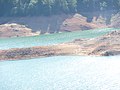
Ten miles (16 km) north of the city of Redding, with the town of Lakehead on its northern shore, Shasta Lake is popular for boating, water skiing, camping, house boating and fishing. Formed by the damming of the Sacramento River, the lake has 365 mi (587 km) of mostly steep mountainous shoreline covered with tall evergreen trees and manzanita. The maximum depth is 517 feet (158 m).

The lake has four major arms, each created by an approaching river: the Sacramento River, the McCloud River, Squaw Creek, and the Pit River. The Sacramento River's source is the Klamath Mountains. The McCloud River's source is Mount Shasta. The Pit River flows from Alturas, and the waterfall Potem Falls is located on that arm of the lake.

History

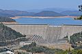
Shasta Dam was constructed between 1935 and 1945 across the Sacramento River, and Shasta Lake was formed in 1948. The Pit River, McCloud River, and several smaller tributaries had their lower courses and confluences with the Sacramento River submerged by the reservoir. Also beneath the lake is the submerged town of Kennett and many village sites of the Wintun people together with their traditional fishing, hunting, and gathering locations. Parts of the defunct tunnels and right of way of the Southern Pacific Transportation Company can be seen when the water level is low.

Shasta Lake hosted the first "Boardstock" event in 1996, which continued there annually through 1999, after which the annual event moved to Clear Lake, California, 170 miles southwest of Shasta Lake. Boardstock drew many professional wakeboard riders from around the world, with an average attendance of 15,000 people. The event lasted for 3 days each year with several wakeboard contests being performed.

Marinas

There are a number of marinas on Shasta Lake offering a variety of services, including houseboat rentals.

Climate

Shasta Lake has a hot-summer mediterranean climate (Csa) typical of the interior of Northern California with hot, dry summers and cool, wet winters, along with great diurnal temperature variation.

Climate data for Shasta Dam, California (normals 1981-2010)(extremes 1943-2020)
MonthJanFebMarAprMayJunJulAugSepOctNovDecYear
Record high °F (°C)80
(27)
80
(27)
88
(31)
97
(36)
107
(42)
111
(44)
115
(46)
115
(46)
114
(46)
104
(40)
90
(32)
76
(24)
115
(46)
Average high °F (°C)53.0
(11.7)
57.0
(13.9)
62.3
(16.8)
68.6
(20.3)
77.6
(25.3)
86.5
(30.3)
95.3
(35.2)
94.3
(34.6)
88.1
(31.2)
76.0
(24.4)
60.3
(15.7)
52.7
(11.5)
72.6
(22.6)
Daily mean °F (°C)46.3
(7.9)
49.2
(9.6)
53.0
(11.7)
58.0
(14.4)
66.3
(19.1)
74.5
(23.6)
81.8
(27.7)
80.6
(27.0)
75.2
(24.0)
65.2
(18.4)
52.9
(11.6)
46.3
(7.9)
62.4
(16.9)
Average low °F (°C)39.5
(4.2)
41.4
(5.2)
43.6
(6.4)
47.4
(8.6)
55.0
(12.8)
62.5
(16.9)
68.3
(20.2)
66.8
(19.3)
62.2
(16.8)
54.4
(12.4)
45.4
(7.4)
40.0
(4.4)
52.5
(11.4)
Record low °F (°C)19
(−7)
21
(−6)
25
(−4)
28
(−2)
35
(2)
38
(3)
50
(10)
44
(7)
43
(6)
34
(1)
30
(−1)
14
(−10)
14
(−10)
Average precipitation inches (mm)10.84
(275)
11.33
(288)
9.48
(241)
4.75
(121)
3.23
(82)
1.37
(35)
0.20
(5.1)
0.25
(6.4)
1.00
(25)
3.68
(93)
7.63
(194)
12.06
(306)
65.82
(1,672)
Average precipitation days1412129731135111493
Source: NOAA [7]

See also

Related Research Articles

<span class="mw-page-title-main">Sacramento River</span> River in Northern and Central California, United States

The Sacramento River is the principal river of Northern California in the United States and is the largest river in California. Rising in the Klamath Mountains, the river flows south for 400 miles (640 km) before reaching the Sacramento–San Joaquin River Delta and San Francisco Bay. The river drains about 26,500 square miles (69,000 km2) in 19 California counties, mostly within the fertile agricultural region bounded by the Coast Ranges and Sierra Nevada known as the Sacramento Valley, but also extending as far as the volcanic plateaus of Northeastern California. Historically, its watershed has reached as far north as south-central Oregon where the now, primarily, endorheic (closed) Goose Lake rarely experiences southerly outflow into the Pit River, the most northerly tributary of the Sacramento.

<span class="mw-page-title-main">Shasta Dam</span> Dam in California, US

Shasta Dam is a concrete arch-gravity dam across the Sacramento River in Northern California in the United States. At 602 feet (183 m) high, it is the eighth-tallest dam in the United States. Located at the north end of the Sacramento Valley, Shasta Dam creates Shasta Lake for long-term water storage, flood control, hydroelectricity and protection against the intrusion of saline water. The largest reservoir in the state, Shasta Lake can hold about 4,500,000 acre-feet (5,600 GL).

<span class="mw-page-title-main">Houseboat</span> Boat used as a home

A houseboat is a boat that has been designed or modified to be used primarily for regular dwelling. Most houseboats are not motorized as they are usually moored or kept stationary at a fixed point, and often tethered to land to provide utilities. However, many are capable of operation under their own power. Float house is a Canadian and American term for a house on a float (raft); a rough house may be called a shanty boat. In Western countries, houseboats tend to be either owned privately or rented out to holiday-goers, and on some canals in Europe, people dwell in houseboats all year round. Examples of this include, but are not limited to, Amsterdam, London, and Paris.

<span class="mw-page-title-main">Lake Oroville</span> Reservoir in Butte County, California, U.S.

Lake Oroville is a reservoir formed by the Oroville Dam impounding the Feather River, located in Butte County, northern California. The lake is situated 5 miles (8 km) northeast of the city of Oroville, within the Lake Oroville State Recreation Area, in the western foothills of the Sierra Nevada. Known as the second-largest reservoir in California, Lake Oroville is treated as a keystone facility within the California State Water Project by storing water, providing flood control, recreation, freshwater releases to assist in controlling the salinity intrusion into the Sacramento-San Joaquin Delta and protecting fish and wildlife.

<span class="mw-page-title-main">Don Pedro Reservoir</span> Reservoir in Tuolumne County, California

Don Pedro Reservoir, also known as Lake Don Pedro, is a reservoir formed by the construction of the New Don Pedro Dam across the Tuolumne River in Tuolumne County, California, United States.

<span class="mw-page-title-main">Lake Success (California)</span> Lake in California

Lake Success is a lake near Porterville, California on the Tule River at 36.06°N 118.92°W. It is formed by Success Dam and has a capacity of 82,000 acre-feet (101,000,000 m3). The 156 feet (48 m) tall earth dam is owned and operated by the U.S. Army Corps of Engineers. Its construction was completed in 1961. The project's primary purpose is flood control, but the lake also provides water for irrigation and recreation. California State Route 190 also crosses the lake's only bridge.

<span class="mw-page-title-main">Clear Creek (Sacramento River tributary)</span> River in California, United States

Clear Creek is a tributary of the upper Sacramento River in northern California.

<span class="mw-page-title-main">Trinity Dam</span> Dam in Trinity County, California

Trinity Dam is an earthfill dam on the Trinity River located about 7 miles (11 km) northeast of Weaverville, California in the United States. The dam was completed in the early 1960s as part of the federal Central Valley Project to provide irrigation water to the arid San Joaquin Valley.

<span class="mw-page-title-main">Trinity Lake</span> Reservoir in Trinity County, California

Trinity Lake, previously called Clair Engle Lake, is an reservoir on the Trinity River formed by the Trinity Dam and located in Trinity County, California, United States. The dam was built by the U.S. Bureau of Reclamation. The lake's capacity is 2,447,650 acre⋅ft (3,019.13 GL), making it one of the largest reservoirs in California. The lake's surface is at 2,370 ft (720 m) above MSL. Trinity Lake captures and stores water for the Central Valley Project, which provides the Central Valley with water for irrigation and produces hydroelectric power. This lake is known for its many small arms, glassy inlets, and good water-skiing conditions.

<span class="mw-page-title-main">Shasta–Trinity National Forest</span> National forest in California, US

The Shasta–Trinity National Forest is a federally designated forest in northern California, United States. It is the largest National Forest in California and is managed by the U.S. Forest Service. The 2,210,485 acre forest encompasses five wilderness areas, hundreds of mountain lakes and 6,278 miles (10,103 km) of streams and rivers. Major features include Shasta Lake, the largest man-made lake in California and Mount Shasta, elevation 14,179 feet (4,322 m).

<span class="mw-page-title-main">Millerton Lake</span> Reservoir in Fresno and Madera counties, California

Millerton Lake is an artificial lake near the town of Friant, about 15 mi (24 km) north of downtown Fresno, California, United States. The reservoir was created by the construction of 319 ft high Friant Dam on the San Joaquin River which, with the lake, serves as much of the county line between Fresno County to the south and Madera County to the north.

<span class="mw-page-title-main">Lake McClure</span> Reservoir in Mariposa County, California

Lake McClure is a reservoir in the Sierra Nevada foothills of western Mariposa County, California, United States.

<span class="mw-page-title-main">New Bullards Bar Reservoir</span> Reservoir in Yuba County, California

New Bullards Bar Reservoir is a large reservoir in northeastern Yuba County, California, United States, at an elevation of 2,000 feet (610 m) in the Tahoe National Forest and about 30 miles (50 km) northeast of Yuba City. The 969,600 acre-foot (1.1960×10⁹ m3) reservoir is formed by New Bullards Bar Dam on the North Yuba River, a tributary of the Yuba River. It also receives a portion of the Middle Fork's flow that is diverted to the reservoir via tunnels.

<span class="mw-page-title-main">Folsom Lake</span> Reservoir on the American River in the Sacramento metropolitan area

Folsom Lake is a reservoir on the American River in the Sierra Nevada foothills of California, United States.

<span class="mw-page-title-main">Whiskeytown–Shasta–Trinity National Recreation Area</span> National recreation area in California, United States

The Whiskeytown–Shasta–Trinity National Recreation Area is a United States National Recreation Area in northern California. The recreation area was authorized in 1965 by the United States Congress. Recreational activities available include swimming, fishing, boating, camping, and hiking.

<span class="mw-page-title-main">Whiskeytown Lake</span> Man-made reservoir in California, United States

Whiskeytown Lake is a reservoir in Shasta County in northwestern California, United States, about 8 miles (13 km) west of Redding. The lake is in the Whiskeytown Unit of the Whiskeytown-Shasta-Trinity National Recreation Area.

<span class="mw-page-title-main">Englebright Lake</span> Reservoir in California, United States

Englebright Lake is an 815 acre reservoir on the Yuba River, impounded by Englebright Dam, in the Sierra Nevada, Northern California, United States. The reservoir stores 45,000 acre feet of water with nearly 24 miles of shoreline.

<span class="mw-page-title-main">Lewiston Lake</span> Reservoir in Trinity County, California

Lewiston Lake is a reservoir impounded by Lewiston Dam on the Trinity River, in Trinity County, California.

<span class="mw-page-title-main">Whiskeytown Dam</span> Dam in California, United States

Whiskeytown Dam is an earthfill dam on Clear Creek, a tributary of the Sacramento River of northern California in the United States.

<span class="mw-page-title-main">Rollins Dam</span> Dam in Nevada County, California

Rollins Dam is a dam on the border of Nevada and Placer counties in northern California, in the United States.

References

  1. "Lake Shasta"; "Lake Shasta"; "Lake Shasta"; "Lake Shasta";
  2. "California: Shasta Dam (U.S. National Park Service)". www.nps.gov. Retrieved 2018-12-27.
  3. "USSD Dam, Hydropower and Reservoir Statistics". United States Society on Dams. Archived from the original on 2014-12-29. Retrieved 2014-11-29.
  4. "Bureau of Reclamation". www.usbr.gov. Retrieved 2018-12-27.
  5. "Bureau of Reclamation". www.usbr.gov. Retrieved 2018-12-27.
  6. Pham, Huyen Tran (2017-01-24). "Shasta Lake". OEHHA. Retrieved 2018-06-13.
  7. "Shasta Dam - NWS Sacramento NOAA Online Weather Data". NOAA. Retrieved February 6, 2021.