Pit River Bridge | |
|---|---|
 | |
| Coordinates | 40°45′44″N122°19′08″W / 40.762337°N 122.318886°W |
| Carries | |
| Crosses | Shasta Lake |
| Locale | Shasta County, California |
| Official name | Veterans of Foreign Wars Memorial Bridge |
| Characteristics | |
| Design | Warren deck truss |
| Total length | 3,588 feet (1,094 m) |
| Height | 500 feet (150 m) |
| Longest span | 630 feet (190 m) |
| No. of spans | 8 |
| Piers in water | 7 |
| History | |
| Opened | 1942 |
| Location | |
 | |
The Pit River Bridge (officially the Veterans of Foreign Wars Memorial Bridge [1] ) is a double deck, deck truss, road and rail bridge over Shasta Lake in Shasta County, California. The bridge, carrying Interstate 5 on its upper deck and Union Pacific Railroad on its lower deck, was built in 1942 as part of the construction of the Shasta Dam/Shasta Lake reservoir system. [2] The Pit River Bridge was constructed to replace the Lower Pit River Bridge, as the rising waters of the Shasta Lake reservoir would have put the older bridge underwater. [3] [4] The entire bridge spans 3,588 feet (1,094 m) long on the upper deck and 2,754 feet (839 m) on the lower deck. [2] With a height of 500 feet (150 m) above the old Pit River bed, it is structurally the highest double decked bridge in the United States; however, today the bridge sits only about 40 feet (12 m) above the water when Shasta Lake is full. [3]
At the time it was built, the highway on the bridge was signed as U.S. Route 99 and the rail line was owned by Southern Pacific. The Coast Starlight , the passenger train line operated by Amtrak that runs between Los Angeles and Seattle, also uses the bridge. [2]
The bridge is officially known as the Veterans of Foreign Wars Memorial Bridge, to honor military veterans from California who have fought in foreign wars. [1]
The Pit River Bridge was the subject of the 1954 Pulitzer Prize for Photography winner entitled "Rescue on Pit River Bridge", taken by Virginia Schau. [5]
 Pit River Bridge
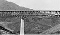 Pit River Bridge before its pylons were inundated by Shasta Lake
 Construction work on Pit River bridge
 Circa 1942
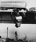 "Rescue on Pit River Bridge"


