San Francisco Peninsula

Last updated

Satellite photo of the San Francisco Bay Area. The San Francisco peninsula protrudes northward. San Francisco is at its tip. Bay Area by Sentinel-2, 2019-03-11 (small version).jpg
Satellite photo of the San Francisco Bay Area. The San Francisco peninsula protrudes northward. San Francisco is at its tip.
Enlarged detail of the tip of the San Francisco Peninsula San Francisco Peninsula by Sentinel-2, 2019-03-11.jpg
Enlarged detail of the tip of the San Francisco Peninsula

The San Francisco Peninsula is a peninsula in the San Francisco Bay Area that separates San Francisco Bay from the Pacific Ocean. On its northern tip is the City and County of San Francisco. Its southern base is Mountain View, in Santa Clara County, south of Palo Alto and north of Sunnyvale and Los Altos. Most of the Peninsula is occupied by San Mateo County, between San Francisco and Santa Clara counties, and including the cities and towns of Atherton, Belmont, Brisbane, Burlingame, Colma, Daly City, East Palo Alto, El Granada, Foster City, Hillsborough, Half Moon Bay, La Honda, Loma Mar, Los Altos, Menlo Park, Millbrae, Pacifica, Palo Alto, Pescadero, Portola Valley, Redwood City, San Bruno, San Carlos, San Mateo, South San Francisco, and Woodside.

Contents

Whereas the term peninsula in a geographical sense technically refers to the entire San Francisco Peninsula, in local jargon, "The Peninsula" does not include the city of San Francisco. [1]

History

In 1795, Governor Diego de Borica gave José Darío Argüello a Spanish land grant known as Rancho de las Pulgas. [2] This rancho was the largest grant on the peninsula consisting of 35,260 acres (142.7 km2). [2]

As a local geographic term, the area referred to as "the Peninsula" is distinct from that denoted by "the City", and refers to the portion south of San Francisco. The appellation may date to the period prior to 1856, when the City of San Francisco and the County of San Francisco were separate entities, the latter then coextensive with contemporary San Mateo County and San Francisco City-County. The City-County owns several disjunct properties along the whole of the Peninsula (mostly water pumping stations connected to the Hetch Hetchy Valley on which San Francisco has a permanent leasehold) thus, most of the larger communities in San Mateo County are de facto suburbs of San Francisco, with the neighboring communities of Pacifica, Daly City, Broadmoor, Colma, South San Francisco, Half Moon Bay, San Bruno, and Brisbane being immediate suburbs. The remaining suburban area of the Peninsula is on the east side of the Santa Cruz Mountains, along San Francisco Bay; the west and south-central portions of the Peninsula are mostly rural, unincorporated, and unorganized areas.

A substantial portion of Silicon Valley is located on the peninsula. In Silicon Valley are the headquarters of some of the largest tech companies in the world, such as Google, Yahoo, Facebook, and Apple. Since 2010, droughts and wildfires have increased in frequency and become less seasonal and more year-round, further straining the region's water security. [3] [4] [5]

Geography and transportation

Along the center line of the Peninsula is the northern half of the Santa Cruz Mountains, formed by the action of plate tectonics along the San Andreas Fault. In the middle of the Peninsula along the fault is the Crystal Springs Reservoir. Just north of the Crystal Springs reservoir is San Andreas Lake, after which the geologic fault was originally named. [6]

The east side of the peninsula is a densely populated and largely urban and suburban area that includes portions of Silicon Valley. It forms a commuter area between San Francisco to the north and San Jose to the south.

Roads

The bridges in the Peninsula include the Dumbarton Bridge, the Golden Gate Bridge, the San Francisco - Oakland Bay Bridge, and the San Mateo–Hayward Bridge.

A number of major thoroughfares run north-south: El Camino Real (SR 82) and US 101 on the east side along the bay, Interstate 280 down the center, Skyline Boulevard (SR 35) along the crest of the Santa Cruz Mountains, and SR 1 on the west along the Pacific, and SR 85 which forms the southern end of the Peninsula.

Transit

Caltrain is the primary passenger rail transit in the peninsula, serving much of the eastern urbanized areas of the peninsula between Mountain View (which also connects to VTA light rail) and San Francisco's 4th and King Street station. In addition, the peninsula has access to Bay Area Rapid Transit (BART) northward of Millbrae, connecting San Mateo County and San Francisco to the East Bay through a route over and under Daly City, Glen Park, San Francisco's Mission district, and through part of Market Street subway.

Bus service is predominantly served by SamTrans and the SFMTA's Muni buses, which primarily run in San Mateo and San Francisco counties respectively. In addition, southward of Palo Alto, the Santa Clara Valley Transportation Authority operates buses to other parts of Santa Clara County. Most of the peninsula's bus transit to the East Bay and North Bay flowing through San Francisco, as neither AC Transit nor Golden Gate Transit, the primary transit operators for the East and North Bay respectively, serve the peninsula south of San Francisco. [7] [8]

Airports

The peninsula's largest commercial airport is San Francisco International Airport, itself connected to US 101 and BART and accessible to Caltrain (via a BART connection at Milbrae station).

San Jose International Airport, is the next largest airport in the region serving and might be a more viable option for the southern peninsula. The airport is connected to US 101 and there is a single connector bus, VTA Line 60, that links to Caltrain (at Santa Clara Transit Center) and to eastern lines of BART (Milpitas). [9]

Oakland International Airport, located in the East Bay, is the smallest of the three and is also accessible directly via BART.

Environmental features

The San Francisco Peninsula contains a variety of habitats including estuarine, marine, oak woodland, redwood forest, coastal scrub and oak savanna. There are numerous species of wildlife present, especially along the San Francisco Bay estuarine shoreline, San Bruno Mountain, Fitzgerald Marine Reserve and the forests on the Montara Mountain block.

The area is home to several endangered species including the San Francisco garter snake, the Mission blue butterfly and the San Bruno elfin butterfly, all of which are endemic to San Mateo County. The endangered California clapper rail is also found on the shores of San Francisco Bay, in the cities of Belmont and San Mateo.

Although tule elk, an elk subspecies found only in California, were historically native to the San Francisco Peninsula, they were hunted to extinction by 1850. [10] Expansion of Diablo Range elk to western Santa Clara County, and San Mateo and Santa Cruz Counties has been blocked by U.S. Highway 101 in Coyote Valley south of San Jose, California. [11]

A number of noteworthy parks and nature preserves are found on the San Francisco Peninsula, including:

Notable structures

There are a number of well-known structures and complexes on the San Francisco Peninsula:

See also

Related Research Articles

<span class="mw-page-title-main">Dumbarton Bridge (California)</span> Southernmost bridge crossing the San Francisco Bay

The Dumbarton Bridge is the southernmost of the highway bridges across San Francisco Bay in California. Carrying over 70,000 vehicles and about 118 pedestrian and bicycle crossings daily, it is the shortest bridge across San Francisco Bay at 1.63 miles. Its eastern end is in Fremont, near Newark in the San Francisco Bay National Wildlife Refuge, and its western end is in Menlo Park. Bridging State Route 84 across the bay, it has three lanes each way and a separated bike/pedestrian lane along its south side. Like the San Mateo Bridge to the north, power lines parallel the bridge.

<span class="mw-page-title-main">Palo Alto, California</span> City in California, United States

Palo Alto is a charter city in the northwestern corner of Santa Clara County, California, United States, in the San Francisco Bay Area, named after a coastal redwood tree known as El Palo Alto.

<span class="mw-page-title-main">San Mateo County, California</span> County in California, United States

San Mateo County, officially the County of San Mateo, is a county located in the U.S. state of California. As of the 2020 census, the population was 764,442. Redwood City is the county seat, and the third most populated city following Daly City and San Mateo. San Mateo County is included in the San Francisco–Oakland–Berkeley, CA MSA, Silicon Valley, and is part of the San Francisco Bay Area, the nine counties bordering San Francisco Bay. It covers most of the San Francisco Peninsula. San Francisco International Airport is located in the northeastern area of the county and is approximately 7 miles (11 km) south of the city and county limits of San Francisco, even though the airport itself is assigned a San Francisco postal address. The county's built-up areas are mostly suburban, and are home to many corporate campuses.

<span class="mw-page-title-main">Menlo Park, California</span> City in California, United States

Menlo Park is a city at the eastern edge of San Mateo County within the San Francisco Bay Area of California, United States. It is bordered by San Francisco Bay on the north and east; East Palo Alto, Palo Alto, and Stanford to the south; and Atherton, North Fair Oaks, and Redwood City to the west. It had 33,780 residents at the 2020 United States census. It is home to the corporate headquarters of Meta, and is where Google, Roblox Corporation and Round Table Pizza were founded. The train station holds the record as the oldest continually operating train station in California. It is one of the most educated cities in California and the United States; nearly 70% of residents over 25 have earned a bachelor's degree or higher.

<span class="mw-page-title-main">Northern California</span> American geographic and cultural region

Northern California is a geographic and cultural region that generally comprises the northern portion of the U.S. state of California, spanning the northernmost 48 of the state's 58 counties. Its main population centers include the San Francisco Bay Area, the Greater Sacramento area, the Redding, California, area south of the Cascade Range, and the Metropolitan Fresno area. Northern California also contains redwood forests, along with most of the Sierra Nevada, including Yosemite Valley and part of Lake Tahoe, Mount Shasta, and most of the Central Valley, one of the world's most productive agricultural regions.

<span class="mw-page-title-main">Caltrain</span> Commuter rail line in San Francisco Peninsula, California

Caltrain is a California commuter rail line serving the San Francisco Peninsula and Santa Clara Valley. The southern terminus is in San Jose at Tamien station with weekday rush hour service running as far as Gilroy. The northern terminus of the line is in San Francisco at 4th and King Street. Caltrain has 28 regular stops, one limited-service weekday-only stop, one weekend-only stop (Broadway), and one football-only stop (Stanford). While average weekday ridership in 2019 exceeded 63,000, impacts of the COVID-19 pandemic have been significant: in August 2022, Caltrain had an average weekday ridership of 18,600 passengers.

<span class="mw-page-title-main">Santa Clara Valley Transportation Authority</span> Public transit operator in Santa Clara County, California

The Santa Clara Valley Transportation Authority, more commonly known simply as the Valley Transportation Authority (VTA), is a special district responsible for public transit services, congestion management, specific highway improvement projects, and countywide transportation planning for Santa Clara County, California. It serves San Jose, California, and the surrounding Silicon Valley. It is one of the governing parties for the Caltrain commuter rail line that serves the county. In 2023, the VTA's public transportation services had a combined ridership of 26,610,000, or about 87,500 per weekday as of the fourth quarter of 2023.

<span class="mw-page-title-main">California State Route 82</span> Highway in California

State Route 82 is a state highway in the U.S. state of California that runs from Interstate 880 (I-880) in San Jose to I-280 in San Francisco following the San Francisco Peninsula. It is the spinal arterial road of the peninsula and runs parallel to the nearby Caltrain line along much of the route. For much of its length, the highway is named El Camino Real and formed part of the historic El Camino Real mission trail. It passes through and near the historic downtowns of many Peninsula cities, including Burlingame, San Mateo, Redwood City, Menlo Park, Palo Alto, Mountain View, Sunnyvale, and Santa Clara, and through some of the most walkable and transit-oriented neighborhoods in the region.

<span class="mw-page-title-main">SamTrans</span> Public transit operator in San Mateo County, California

SamTrans is a public transport agency in and around San Mateo, California, in the San Francisco Bay Area. It provides bus service throughout San Mateo County and into portions of San Francisco and Palo Alto. SamTrans also operates commuter shuttles to BART stations and community shuttles. Service is largely concentrated on the east side of the Santa Cruz Mountains, and, in the central county, I-280, leaving coast-side service south of Pacifica spotty and intermittent.

<span class="mw-page-title-main">Transportation in the San Francisco Bay Area</span> Overview of transportation in the San Francisco Bay Area, California, United States

People in the San Francisco Bay Area rely on a complex multimodal transportation infrastructure consisting of roads, bridges, highways, rail, tunnels, airports, seaports, and bike and pedestrian paths. The development, maintenance, and operation of these different modes of transportation are overseen by various agencies, including the California Department of Transportation (Caltrans), the Association of Bay Area Governments, San Francisco Municipal Transportation Agency, and the Metropolitan Transportation Commission. These and other organizations collectively manage several interstate highways and state routes, eight passenger rail networks, eight trans-bay bridges, transbay ferry service, local and transbay bus service, three international airports, and an extensive network of roads, tunnels, and bike paths.

<span class="mw-page-title-main">All Nighter (bus service)</span> San Francisco Bay Area late night bus service

The All Nighter is a night bus service network in the San Francisco Bay Area, California. Portions of the service shadow the rapid transit and commuter rail services of BART and Caltrain, which are the major rail services between San Francisco, the East Bay, the Peninsula, and San Jose. Neither BART nor Caltrain operate owl service due to overnight track maintenance; the All Nighter network helps fill in this service gap. The slogan is, "Now transit stays up as late as you do!"

<span class="mw-page-title-main">Peninsula Commute</span> Passenger rail service between San Francisco and San Jose

The Peninsula Commute, also known as the Southern Pacific Peninsula or just Peninsula, was the common name for commuter rail service between San Jose, California and San Francisco, California on the San Francisco Peninsula. This service ran as a private, for-profit enterprise beginning in 1863. Due to operating losses, the Southern Pacific Railroad (SP) petitioned to discontinue the service in 1977. Subsidies were provided through the California Department of Transportation (Caltrans) in 1980 to continue service, and it was renamed Caltrain.

<span class="mw-page-title-main">Palo Alto station</span> Train station in Palo Alto, California, U.S.

Palo Alto station is an intermodal transit center in Palo Alto, California. It is served by Caltrain regional rail service, SamTrans and Santa Clara VTA local bus service, Dumbarton Express regional bus service, the Stanford University Marguerite Shuttle, and several local shuttle services. Palo Alto is the second-busiest Caltrain station after San Francisco, averaging 7,764 weekday boardings by a 2018 count. The Caltrain station has two side platforms serving the two tracks of the Peninsula Subdivision and a nearby bus transfer plaza.

Throughout the history of Bay Area Rapid Transit, there have been plans to extend service to other areas.

<span class="mw-page-title-main">Santa Clara County, California</span> County in California, United States

Santa Clara County, officially the County of Santa Clara, is the sixth-most populous county in the U.S. state of California, with a population of 1,936,259, as of the 2020 census. Santa Clara County and neighboring San Benito County together form the U.S. Census Bureau's San Jose–Sunnyvale–Santa Clara metropolitan statistical area, which is part of the larger San Jose–San Francisco–Oakland combined statistical area. Santa Clara is the most populous county in the San Francisco Bay Area and in Northern California. The county seat and largest city is San Jose; with about 1,000,000 residents, it is the 10th-most populous city in the United States, California's third-most populous city and the most populous city in the San Francisco Bay Area. The second- and third-largest cities are Sunnyvale and Santa Clara.

<span class="mw-page-title-main">Peninsula Library System</span>

The Peninsula Library System (PLS) is a consortium of public and community college libraries in San Mateo County, California, United States, which serves the part of the San Francisco Bay Area known as "The Peninsula". The system has dozens of branches in local communities and at various area community colleges, a bookmobile, and automated book kiosks called Library-a-Go-Go.

<span class="mw-page-title-main">Dumbarton Rail Corridor</span> Passenger Rail Line

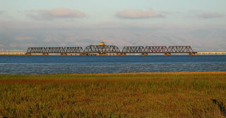
The Dumbarton Rail Corridor is a proposed transbay passenger rail line which would reuse the right-of-way that was initially constructed from 1907–1910 as the Dumbarton Cut-off. The Dumbarton Cut-off includes the first structure to span San Francisco Bay, the 1910 Dumbarton Rail Bridge, although the vintage Cut-off bridges would likely be replaced prior to activating new passenger service. Dumbarton Rail Corridor would provide service between Union City in the East Bay and Menlo Park on the Peninsula, with train service continuing to both San Francisco and San José along the existing Caltrain tracks. It has been in the planning stages since 1988, and would be the first above-ground transbay rail line since Key System electric trains stopped running on the lower deck of the Bay Bridge in 1958, and the first new transbay crossing of any kind since the completion of the Transbay Tube in 1974.

<span class="mw-page-title-main">Caltrain Express</span> Faster San Francisco-San Jose rail service

The Caltrain Express (CTX) project was implemented from 2002 to 2004 and led to the establishment of the Baby Bullet express service, which shortened the transit time between San Francisco and San Jose, and certain stations in between. New locomotives and rolling stock were purchased for dedicated express service, bypassing most stations; quad-track overtake sections were added in two locations along the Peninsula Corridor right-of-way to allow express trains to pass slower local trains that were making all stops; tracks were also upgraded with continuous-welded rail; a centralized traffic control system was added; and crossovers were added every few miles to allow single-tracking trains around disabled trains. Congresswoman Jackie Speier, then serving as a California State Senator, is credited with securing the funding for CTX and one of the new locomotives acquired for the project is named for her as a result. During commute hours, the Baby Bullet is up to 20% faster than driving south from San Francisco to San Jose.

References

  1. "SF planning commission discusses closing parts of the Great Highway". ABC7News. 2017. Retrieved November 26, 2018.
  2. 1 2 "Early days in Menlo Park". ci.menlo-park.ca.us. 2002. Archived from the original on May 4, 2011. Retrieved May 4, 2010.
  3. "Drought.gov". National Integrated Drought Information System . Archived from the original on June 8, 2023. Retrieved June 10, 2023.
  4. Boxall, Bettina; St. John, Paige (November 10, 2018). "California's most destructive wildfire should not have come as a surprise". Los Angeles Times . Retrieved May 8, 2022.
  5. "Advancing Drought Science and Preparedness across the Nation". National Integrated Drought Information System. Archived from the original on November 11, 2018. Retrieved May 8, 2022.
  6. Carol S. Prentice, "Andrew Cowper Lawson", in Classic Cordilleran Concepts: A View from California, Special paper 338, Boulder, Colorado: Geological Society of America, 1999, ISBN   9780813723389, p. 70.
  7. "Find Your Route & Stop - Riding the Bus | Golden Gate". www.goldengate.org. Retrieved December 8, 2022.
  8. AC Transit. "Schedule and Fares for Daly City" (PDF). Retrieved December 8, 2022.
  9. "Santa Clara Valley Transportation Authority:Milpitas BART - Winchester Stn via SJC Airport" . Retrieved March 17, 2024.
  10. Richard B. Lanman, William C. Leikam, Monica V. Arellano, Alan Leventhal, Valentin Lopez, Ryan A. Phillips, Julie A. Phillips, Kristin Denryter (2022). "A review of considerations for restoration of tule elk to the San Francisco Peninsula and northern Monterey Bay counties of California". California Fish and Wildlife Journal. 108 (3): 62–93. doi:10.51492/cfwj.108.14 . Retrieved February 16, 2024.{{cite journal}}: CS1 maint: multiple names: authors list (link)
  11. Thomas Connor, Thomas J. Batter, Cristen O. Langer, Jeff Cann, Cynthia McColl, Richard B. Lanman (2023). "Habitat suitability assessment for tule elk in the San Francisco Bay and Monterey Bay areas". California Fish and Wildlife Journal. 109: e19. Retrieved February 16, 2024.{{cite journal}}: CS1 maint: multiple names: authors list (link)
  12. Archived November 15, 2011, at the Wayback Machine

37°35′00″N122°24′04″W / 37.58333°N 122.40111°W / 37.58333; -122.40111