Sierra Point (Brisbane)

Last updated
Aerial view of Sierra Point in 2018, facing approximately northeast. Sierra Point aerial view, February 2018.JPG
Aerial view of Sierra Point in 2018, facing approximately northeast.

Sierra Point is a small artificial peninsula that extends eastward into the San Francisco Bay from the eastern shore of the San Francisco Peninsula, located in Brisbane, San Mateo County, California (although the south part of the business park extends into South San Francisco). It lies entirely east of U.S. Route 101 . There are several class A office buildings at Sierra Point including the Dakin Building and the former Hitachi building. The Brisbane Marina is on the eastern shore of Sierra Point. The San Francisco Bay Trail runs along the waterfront of the peninsula and continues south into the Oyster Point area of South San Francisco.

Contents

History and characteristics

Sierra Point encompasses an area of 132 acres (53 ha), reclaimed from San Francisco Bay by landfill behind dikes. [1] 102 acres (41 ha) are for the office park and 30 acres (12 ha) are for the Brisbane Marina. [2] It is one of two large commercial districts in Brisbane; the older Crocker Industrial Park north of the residential area of Brisbane was developed during the 1960s. [3] :5

The Sunset Scavenger Company let a contract to the Easley and Brassy Company, who constructed an earthen dike from 1965 to 1967 around the existing site perimeter, on the existing mud flat east of San Bruno Mountain. The area, then named the Sierra Point Solid Waste Disposal Site, was used as an unlined Class III landfill between 1965 and 1972, covered daily with soil taken from Candlestick Point. [4] [5] :3–4 In total, 80 acres (32 ha) were used for the disposal of an estimated 1,900,000 to 2,600,000 cubic yards (1,500,000 to 2,000,000 m3) of solid waste. [4]

The entire site was purchased by Sierra Point Development Company (SPDC) from Sunset Scavenger in 1975. [5] :4 SPDC donated approximately 20 acres (8.1 ha) for a municipal marina to the City of Brisbane in 1980, [4] in partial exchange for development rights to the site. After it was complete, the city would assume control of the marina and collect property taxes on the improved site. [6] Development of the Sierra Point area was approved in 1979 and started in 1982. [3] The San Francisco Regional Water Quality Control Board adopted Order 82-27 in June 1982 to provide landfill closure requirements; that was subsequently rescinded and superseded by Order 96-058 in 1996. [4] [5] :4 SPDC subsequently sold the site to Sierra Point Associates Two (SPA2) in November 1983. [4]

By 1996, 70 acres (28 ha) of the landfill site had been capped with a minimum of 3 feet (0.91 m) of clean soil and 1 foot (0.30 m) of compacted clay. [4] In 2001, the elevation of Sierra Point was 15 feet (4.6 m) above sea level, with settlement expected to reduce the elevation to 12 feet (3.7 m) over the next 100 years. [1]

Development

Selected locations in Sierra Point:
1
7000 Marina Blvd (Dakin Building)
2
5000 Marina Blvd
3
3000–3500 Marina Blvd (under construction)
4
1000 Marina Blvd (former Hitachi Building)
5
2000 Sierra Point Pkwy
6
8000 Marina Blvd
7
9000 Marina Blvd (undeveloped)
8
5000 Sierra Point Pkwy (hotel)
9
2000 Shoreline Ct (hotel)
10
Future biotech campus
11
Future Sierra Point Plaza
12
4000 Shoreline Ct
13
5000 Shoreline Ct
14
6000 Shoreline Ct
15
7000 Shoreline Ct

As of 2008, Sierra Point has not been completely built out. Existing buildings include two office buildings north of the Marina loop (7000 Marina  1  and 5000 Marina  2 ), the oldest building at Sierra Point, an office building covered in dark glass just east of 101 and west of Marina (1000 Marina Blvd  4 ), two office buildings in the loop enclosed by Marina and Sierra Point (2000 Sierra Point Pkwy  5  and 8000 Marina Blvd  6 ), and two hotels in the southwest corner (near the western intersection of Marina and Sierra Point,  8  and  9 ). The parcel north of the oldest building is known as Parcel 3  3  [to become 3000–3500 Marina Blvd (under construction as of October 2022)], the area northeast of the eastern intersection of Marina and Sierra Point is zoned for another hotel  7 , the parcel south of Sierra Point Pkwy has been approved for the Sierra Point Biotech Project  10 , and the area east of the terminus of Sierra Point Pkwy is zoned for retail use and the planned Sierra Point Plaza  11 . [7]

There are buildings at 4000, 5000, 6000, and 7000 Shoreline Court ( 12  15 ) in the southern portion of Sierra Point which lies within the City of South San Francisco.

Brisbane Marina

The Brisbane Marina was completed in 1983 along the eastern shore of Sierra Point and has slips for up to 580 boats. [8] The Marina was built by a private developer at the city's expense in exchange for a long-term lease for the entire Sierra Point site; in addition, the developer would subsidize the loan payments for the money the city had borrowed to build the Marina. [6]

The Sierra Point Yacht Club was established in 1984 to support boaters and boating activities at Brisbane Marina; initial meetings were held at local restaurants, and the first Club building was a maintenance building rented from the City of Brisbane starting from 1988. The Club moved into its present site at 500 Sierra Point Parkway, near the southeast corner of Sierra Point, in 2000. [6]

7000 Marina  1  and 5000 Marina  2 

This area, north of Marina Boulevard, was originally designated Parcel 4 and is 8.00 acres (3.24 ha). [4] The Dakin Building was the first building to be developed at this site, at 7000 Marina.

3000–3500 Marina  3 

The northwest corner of Sierra Point is also known as Parcel 3, which occupies approximately 8.867 acres (3.588 ha). [4] The City of Brisbane approved the development of the Opus Office Center on Parcel 3 in 2009, which would include two office buildings and a five-story parking structure. In 2012, the City of Brisbane adopted development agreement DA-1-11; the project was largely unchanged except the development rights were extended to June 2022 and the buildings were required to be certified LEED Gold. [9] :5–6 An addendum was adopted in 2017 to further extend the development rights to 2027 in exchange for reverting control of Parcel R to the City of Brisbane. [10]

Proposed buildings at Opus Office [9] :11–13
BldgLevelsTotal areaFootprint
1 (3500)8195,500 sq ft
18,160 m2
 ?
2 (3000)10250,000 sq ft
23,000 m2
 ?
Garage5377,515 sq ft
35,072.3 m2
 ?

In 2018, the site was transferred to Phase 3 Real Estate Partners, who have proposed a biotech campus tentatively named Genesis Marina with approximately the same area in three buildings. [11] The Planning Commission approved Design Permit DP-1-18 to modify the site plans in accordance with the Phase 3 design in November 2018. [10]

Proposed buildings at Genesis Marina [12]
BldgLevelsTotal areaFootprint
15+2 [lower-alpha 1] 138,115 sq ft
12,831.3 m2
 ?
25+2 [lower-alpha 1] 139,316 sq ft
12,942.9 m2
 ?
36+2 [lower-alpha 1] 133,046 sq ft
12,360.4 m2
 ?
Parking2257,677 sq ft
23,939.0 m2 [lower-alpha 2]
 ?
Notes
  1. 1 2 3 Constructed above a 2-story parking podium
  2. Excludes 35,922 square feet (3,337.3 m2) of mechanical & storage space and 12,075 square feet (1,121.8 m2) fitness center.

1000 Marina  4 

The 1000 Marina site consists of a parcel that is 4.516 acres (1.828 ha). [4] The dark glass building at this site was built for Unisys. The 100,000 sq ft (9,300 m2) building was sold to Spieker Properties for $10 million in 1997. [13]

2000 Sierra Point  5  & 8000 Marina  6 

This site, enclosed by the loop formed by Marina Boulevard and Sierra Point Parkway, consists of two parcels: Parcel 8 (western half), 10.199 acres (4.127 ha) and Parcel 9 (eastern half), 5.662 acres (2.291 ha). [4] Parcel 8 was the first to be developed with Hitachi America's west coast headquarters.

Hotels  7  8  9 

Two hotels occupy Parcel 1, which is 6.849 acres (2.772 ha) in the southwest corner of Sierra Point. The undeveloped parcel in the northeast corner of Sierra Point is designated for a luxury/convention hotel and occupies 6.126 acres (2.479 ha). [4]

Biotech Project  10 

The Sierra Point Biotech Project  10  consists of five buildings and one parking garage south of Sierra Point Parkway and east of Shoreline Court. [14] The Biotech Project encompasses three separate parcels on the Sierra Point site, consisting of (from west to east) Parcel 7, 7.975 acres (3.227 ha); Parcel 6, 9.088 acres (3.678 ha); and Parcel 5, 5.793 acres (2.344 ha). [4]

Proposed buildings at Biotech Project [lower-alpha 1] [15]
BldgLevelsTotal areaFootprint
A390,005 sq ft
8,361.7 m2
29,947 sq ft
2,782.2 m2
B4120,225 sq ft
11,169.3 m2
30,436 sq ft
2,827.6 m2
C4+1 [lower-alpha 2] 120,225 sq ft
11,169.3 m2
30,436 sq ft
2,827.6 m2
D390,078 sq ft
8,368.5 m2
30,026 sq ft
2,789.5 m2
E4119,652 sq ft
11,116.0 m2
29,772 sq ft
2,765.9 m2
Garage5+1 [lower-alpha 3] 337,587 sq ft
31,362.9 m2
58,671 sq ft
5,450.7 m2
Notes
  1. Listed in order from west to east
  2. +1 level for 136 sub-surface parking spaces
  3. 1 floor below grade, 4 floors above grade, and space on rooftop for 1,249 parking spaces

It is anticipated there would be space for 1,800 employees at the Biotech Project campus. [15] :33 The project would also provide 2,500 square feet (230 m2) of retail space on the first floor of the parking garage. [15] :38

Sierra Point Plaza  11 

Parcel R is a 3.4-acre (1.4 ha) lot at the eastern terminus of Sierra Point Parkway, with an address of 400 Sierra Point Pkwy. It is owned by the City of Brisbane, but was leased in 1984 to a private developer to build up to 50,000 square feet (4,600 m2) of commercial space. After the lease was signed, 12,500 square feet (1,160 m2) were re-allocated to the Biotech Project site, reducing the developable area to 37,500 square feet (3,480 m2). As of 2016, the site has not been developed beyond partial paving for a surface parking lot and a public park. [9] :6–11

Under the 2016 Development Agreement DA-1-16, the lease for Parcel R was terminated and control of the site was returned to Brisbane; further development of Parcel R was frozen until the city decides what to do with the site. [9] :14

4000–7000 Shoreline  12  13  14  15 

Parcel 10 lies south of the hotels in Parcel 1, entirely in the City of South San Francisco, and occupies 26.78 acres (10.84 ha). [4]

Transportation

Aerial view of Sierra Point, looking west-northwest towards San Bruno Mountain in 2016. Bayshore Freeway runs north-south through the middle of the photograph. Bay Area from above (31222388996) (cropped).jpg
Aerial view of Sierra Point, looking west-northwest towards San Bruno Mountain in 2016. Bayshore Freeway runs north-south through the middle of the photograph.

Exits along the San Francisco Peninsula's principal highway, U.S. Highway 101 (the Bayshore Freeway), lead to Sierra Point Parkway. Sierra Point Parkway runs approximately east-west for its length east of 101, and crosses under the freeway and runs north-south along the west side of 101 and east of Brisbane Lagoon. The southbound exit from 101 leads to the northernmost end of Sierra Point Parkway, where it intersects with Lagoon Road. The northbound exit from 101 is near where Sierra Point Parkway crosses under the freeway. Sierra Point is connected to the rest of Brisbane via the northern end of Sierra Point Parkway.

Marina Boulevard is the other primary road in Sierra Point; it forms a loop north of Sierra Point Parkway. South of the Parkway from its western intersection, it becomes Shoreline Court.

Although the Caltrain Bayshore Cutoff line runs along the west side of Sierra Point, there are no stops. The nearest stops are Bayshore to the north and South San Francisco to the south; the former Butler Road stop at Oyster Point just to the south of Sierra Point was removed in 1983.

Businesses

Former

Related Research Articles

<span class="mw-page-title-main">Brisbane, California</span> City in the state of California, United States

Brisbane is a small city located in California in the northern part of San Mateo County on the lower slopes of San Bruno Mountain. It is located on the southern border of San Francisco, on the northeastern edge of South San Francisco, next to San Francisco Bay and near San Francisco International Airport. The population was 4,851 as of the 2020 census.

<span class="mw-page-title-main">South San Francisco, California</span> City in San Mateo County in the State of California, United States

South San Francisco is a city in San Mateo County, California, United States, located on the San Francisco Peninsula in the San Francisco Bay Area. The city is colloquially known as "South City". The population was 66,105 at the 2020 census.

<span class="mw-page-title-main">Treasure Island, San Francisco</span> Landform and neighborhood of San Francisco in California, United States

Treasure Island is an artificial island in the San Francisco Bay and a neighborhood in the City and County of San Francisco. Built in 1936–37 for the 1939 Golden Gate International Exposition, the island's World's Fair site is a California Historical Landmark. Buildings there have been listed on the National Register of Historic Places, and the historical Naval Station Treasure Island, an auxiliary air facility, are designated in the Geographic Names Information System.

<span class="mw-page-title-main">Coyote Point Recreation Area</span> Park in San Mateo County, California, US

Coyote Point Recreation Area is a 670-acre (270 ha) park operated by San Mateo County, California in the United States. Located on San Francisco Bay, it is south of San Francisco International Airport on the border of Burlingame and San Mateo. Facilities within the park include a large playground, the CuriOdyssey junior museum, a sandy bathing beach, a marina and yacht club, hiking trails, and picnic areas. In addition, the San Mateo County Sheriff's office has a shooting range on-site for training of law enforcement. It is adjacent to the Peninsula Humane Society and the municipal Poplar Creek Golf Course.

<span class="mw-page-title-main">Mission Bay, San Francisco</span> Neighborhood in San Francisco, California, United States

Mission Bay is a 303-acre (123 ha) neighborhood on the east side of San Francisco, California. It is bordered by China Basin to the north, Dogpatch to the south, and San Francisco Bay to the east. Originally an industrial district, it underwent development fueled by the construction of the UCSF Mission Bay campus, and is currently in the final stages of development and construction. It is the site of the Chase Center.

<span class="mw-page-title-main">San Bruno Mountain</span> Mountain in California, United States

San Bruno Mountain is a horst fault block mountain located in northern San Mateo County, California; with some northern slopes crossing over into southern San Francisco, it is also surrounded by San Francisco Bay and the cities of Brisbane, Colma, Daly City, and South San Francisco.

<span class="mw-page-title-main">Golden Gate National Recreation Area</span> U.S. National Recreation Area surrounding San Francisco Bay Area

The Golden Gate National Recreation Area (GGNRA) is a U.S. National Recreation Area protecting 82,116 acres (33,231 ha) of ecologically and historically significant landscapes surrounding the San Francisco Bay Area. Much of the park is land formerly used by the United States Army. GGNRA is managed by the National Park Service and is the most visited unit of the National Park system in the United States, with more than 15 million visitors a year. It is also one of the largest urban parks in the world, with a size two-and-a-half times that of the consolidated city and county of San Francisco.

<span class="mw-page-title-main">Dakin Building</span> Office building in California, U.S.

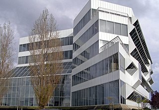
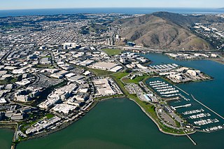
The Dakin Building is an architectural award-winning class A office building on the San Francisco Bay in Brisbane, California. Serving as a corporate headquarters building for several companies of national prominence, it was built from the profits of the Garfield character whose licensed products of the R. Dakin Company division of Applause Toys soared in sales in the late 1980s. Located on Sierra Point, it became a landmark in the San Francisco Bay Area for its distinctive design and was nicknamed the Luke Skywalker building for its dramatic posture overlooking the bay, in contrast to a neighboring office building with a dark, ominous appearance that was nicknamed the Darth Vader building.

<span class="mw-page-title-main">McLaughlin Eastshore State Park</span> State park and wildlife refuge

McLaughlin Eastshore State Park is a state park and wildlife refuge along the San Francisco Bay shoreline of the East Bay between the cities of Richmond, Albany, Berkeley, Emeryville, and Oakland. It encompasses remnant natural wetlands, restored wetlands, as well as landfill west of the Eastshore Freeway. Its shoreline is 8.5 miles (13.7 km) long, and its total area is 1,854 acres (750 ha), which includes both tidelands and uplands. Originally named just Eastshore State Park, it was renamed in October 2012 to honor the late Save the Bay founder Sylvia McLaughlin, who, along with the late Dwight Steele of Citizens for Eastshore Park, drove the establishment of the park. Prior to 2013, it was jointly managed by the California State Parks and East Bay Regional Park District (EBRPD). The state agency and EBRPD executed a 30-year agreement for EBRPD to manage the park.

Schoonmaker Point is a low-lying landform jutting into San Francisco Bay at Sausalito, California. This area was created by dredge spoils from Richardson Bay during local Marin Shipyards shipbuilding activity during World War II. Schoonmaker Point is situated approximately 1.7 miles (2.7 km) south of the Sausalito/Marin City interchange of U.S. Highway 101 immediately north of Bridgeway Boulevard. The Schoonmaker Point Marina is located here, along with a 2.3-acre (9,300 m2) sand beach.. From Schoonmaker Point there are views of Mount Tamalpais and the San Francisco downtown skyline.

<span class="mw-page-title-main">Foster City Marina</span>

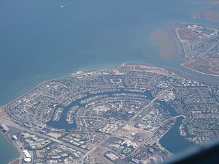
The Foster City Marina is a planned facility for waterfront land use and boat berthing in Foster City, California. The site area is 60 acres (24 ha) and the marina site is the only land use designated as "waterfront commercial" by the city's General Plan. The original formal planning for the Foster City Marina began in the mid 1980s when the city council authorized Earth Metrics Inc to prepare an Environmental Impact Report for the marina use. The marina is designed to provide berthing for 750 vessels, and this site has been the focus of considerable political debate as to the timing of development.

<span class="mw-page-title-main">Westlake Shopping Center</span> Shopping mall in CA, United States

Westlake Shopping Center is one of the first shopping malls built in America; ground was broken in 1948 for the mall in Daly City, California, United States. It is anchored by Burlington Coat Factory, Home Depot, Ross, Safeway, Target, and Walgreens.

Pacific Commons is a master-planned, mixed-use development consisting of 840 acres in Fremont, California currently in development by Catellus Development Corporation. It sits on part of the site of what was once the Fremont Dragstrip/Baylands Raceway Park and the Sky Sailing Airport, a glider field. Given Fremont's location at the Northern tip of Silicon Valley, Catellus originally planned the development to house primarily high-tech research and development operations with a moderate amount of retail and restaurant space, a convention center, and a hotel. Until the dot-com bubble, Cisco Systems had planned to relocate its headquarters to Pacific Commons and consolidate substantially all of its San Francisco Bay Area operations to a large campus in Pacific Commons, which would have consisted of several high-rise office buildings. With the downturn in the technology industry, however, Cisco put its plans on hold. While it is unclear whether Cisco will ultimately relocate its headquarters to Fremont, in 2011 Cisco purchased 149 acres of vacant land in Fremont, most of it from Catellus, fueling speculation that, at some point, it will move forward with its headquarters move to Pacific Commons.

<span class="mw-page-title-main">Oyster Point Marina/Park</span>

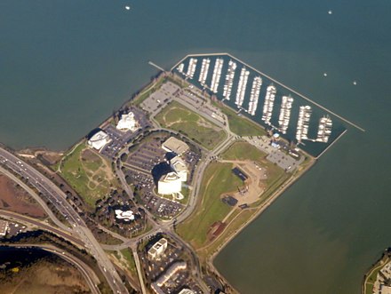
Oyster Point Marina/Park is a 408-berth public marina and 33-acre (13 ha) park located in the city of South San Francisco, California on the western shoreline of San Francisco Bay.

<span class="mw-page-title-main">Dotson Family Marsh</span>

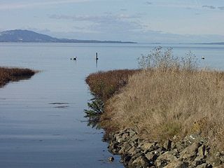
The Dotson Family Marsh, formerly Breuner Marsh, is a 238-acre regional park on San Pablo Bay in the East San Francisco Bay Area city of Richmond, California, In 2009 the East Bay Regional Parks District acquired the Breuner Marsh site, adding it to Point Pinole Regional Shoreline. A habitat restoration plan for 60 acres of wetlands and 90 acres of California coastal prairie was subsequently approved.

<span class="mw-page-title-main">Roberts Landing, California</span> Former settlement in California, United States

Roberts Landing was a settlement in Alameda County, California, now incorporated into the town of San Leandro. It is located at the mouth of San Lorenzo Creek on San Francisco Bay just west of the community of San Lorenzo. In the 19th century, it had warehouses and a wharf, and was used by farmers to ship their produce to the city of San Francisco. From 1906 to 1964, it was the site of an explosives manufacturing plant operated by the Trojan Powder Company. Following the plant's closure, the site was decontaminated. After protracted discussions, part was made into a housing development while a larger part was made an open space that is now also called the San Leandro Shoreline Marshlands.

<span class="mw-page-title-main">Brisbane Baylands development</span> Place

The Brisbane Baylands is a 660-acre (270 ha) parcel of land in Brisbane, just south of the San Francisco border. There have been several proposals to develop the site, which was previously used as a railyard and a municipal landfill; historical uses have led to contaminated soil, polluted stormwater runoff, and potential buried toxic waste. None of the present proposals have been approved by Brisbane's city council.

<span class="mw-page-title-main">Bayview Park, San Francisco</span>

Bayview Park is a 46.63-acre (18.87 ha) park in the Bayview-Hunters Point neighborhood of southeast San Francisco. The park's land is mainly occupied by a large hill named either Bayview Hill or Candlestick Hill, west of the former site of Candlestick Park and east of the Bayshore Freeway; it is prominently visible from both. The hill was initially proposed as parkland by Daniel Burnham in his 1905 Burnham Plan for San Francisco as Visitacion Park, but the park was not created until 1915. Prior to that, the title to the land was held by the Bay View Land Company, which intended to erect luxury houses on the site. After plans for housing fell through, it was proposed to create a pest house on the site in 1902 until the Crocker Land Company donated adjacent land to the city to block plans for the pest house. KYA (1260 AM) opened a studio and 5000-watt radio transmitter on the hill in 1937, and further development of the area occurred in 1958, when part of the hill was quarried to create fill and land for Candlestick Park. Currently, the park receives relatively few visitors to what is considered one of the best-preserved remnants of pre-Columbian open spaces in San Francisco.

<span class="mw-page-title-main">MIRA (building)</span> Residential condominiums in San Francisco, California

MIRA is a 39-story, 422-foot (129 m) residential skyscraper under construction at 280 Spear Street in San Francisco, California.

<span class="mw-page-title-main">Bayshore Cutoff</span> United States historic place

The Bayshore Cutoff is the rail line between San Francisco and San Bruno along the eastern shore of the San Francisco Peninsula. It was completed by Southern Pacific (SP) in 1907 at a cost of $7 million, and included five tunnels, four of which are still used by Caltrain, the successor to Southern Pacific's Peninsula Commute service. Fill from the five tunnels was used to build the Visitacion or Bayshore Yard, the main SP classification yard near the city of Brisbane. The Del Monte was similarly rerouted over the line at some point in its operational history.

References

  1. 1 2 OPUS West Corporation (March 12, 2001). Combined Site and Architectural Design Guidelines: Sierra Point, Brisbane, California (PDF) (Report). City of Brisbane. Retrieved 11 November 2019.
  2. The Brisbane Open Space & Ecology Committee (August 27, 2001). Brisbane Open Space Plan for the City of Brisbane (PDF) (Report). City of Brisbane. Retrieved 11 November 2019.
  3. 1 2 Revealing the Hidden Gem: Local Economic Development in Brisbane, An Action Plan (PDF) (Report). City of Brisbane. July 11, 2013. Retrieved 11 November 2019.
  4. 1 2 3 4 5 6 7 8 9 10 11 12 13 Order No. 96-058: Updated waste discharge requirements for Sierra Point Development Company, the City of Brisbane, Sierra Point Associates One, Sierra Point Associates Two, Hitachi America Ltd., Tuntex Properties Inc., and Argentum International, Inc (PDF) (Report). California Regional Water Quality Control Board, San Francisco Bay Region. 1996. Retrieved 12 November 2019.
  5. 1 2 3 LSA Associates (November 2008). Opus Office Center initial study/mitigated negative declaration (PDF) (Report) (Public Review Draft ed.). City of Brisbane. Retrieved 12 November 2019.
  6. 1 2 3 McDaniel, Jerry (December 2000). "History of the Club House". Sierra Point Yacht Club. Retrieved 12 November 2019.
  7. "3: Conceptual Master Plan" (PDF). Combined Site and Architectural Design Guidelines (Report) (draft ed.). City of Brisbane. August 28, 2008. Retrieved 11 November 2019.
  8. "About Brisbane Marina". City of Brisbane. Retrieved 12 November 2019.
  9. 1 2 3 4 LSA Associates (December 2016). Addendum to the Opus Office Center initial study/mitigated negative declaration (PDF) (Report). City of Brisbane. Retrieved 12 November 2019.
  10. 1 2 Ayres, Julia (November 29, 2018). Planning Commission Agenda Report, 3000-3500 Marina Boulevard; Design Permit Modification DP-1-18, Variance V-1-18, Use Permit UP-1-18 and Environmental Review ER-1-18 (PDF) (Report). City of Brisbane, Planning Commission. Retrieved 12 November 2019.
  11. Torres, Blanca (February 26, 2018). "As South San Francisco sizzles, developer pickes up huge biotech site in neighboring city" . San Francisco Business Times. Retrieved 12 November 2019.
  12. Wallace, Theresa; Wiswell, Matthew (November 2, 2018). California Environmental Quality Act (CEQA) Addendum for the 3000-3500 Marina Boulevard Project, Brisbane, California (PDF) (Report). City of Brisbane. Retrieved 12 November 2019.
  13. Feuerstein, Adam (July 6, 1997). "MetLife sells off Bay Area Property" . San Francisco Business Times. Retrieved 12 November 2019.
  14. "Sierra Point Project drawings" (PDF). DES Architects Engineers. January 15, 2008. Retrieved 11 November 2019.
  15. 1 2 3 Sierra Point Biotech Project Environmental Impact Report (PDF) (Report). LSA. November 2006. Retrieved 11 November 2019.
  16. , Ideaya Biosciences - Contact Us Page